


Research and Application of Three-Dimensional Visibility Based on Digital Map
-
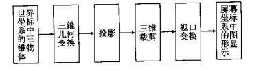
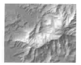
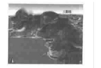
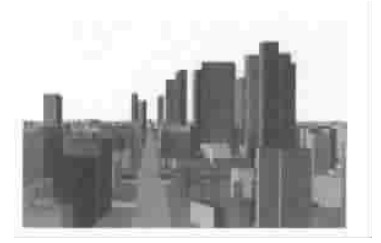
摘要: 三维可视化理论与技术的引入使得传统静态的、平面的地图向动态的、三维的方向发展, 地图的三维可视化正成为GIS与数字制图领域的一个新的研究课题.数字地图及其建库技术的研究为其三维可视化研究提供了有力的技术支持和充足的数据来源.主要研究基于等高线与离散高程点的地形模型(DEM) 的建立、兼顾地形(即基于DEM) 的街区与街道、居民地模型的建立, 以及植被、道路、水系等各主要要素的三维模型的建立及其显示, 对三维点状地图符号库的建立、模型的动态显示及航空影像的叠加显示等进行了研究.最后对三维可视化技术在基于数字地图的地貌晕渲、模拟飞行、虚拟城市等方面的应用作了探讨.Abstract: The application of 3D visibility theory and technology in the cartography science promotes the evolution of the traditional, static and planar maps toward the dynamical and 3D maps, and this has become a new research field of geographic information system (GIS) and digital cartography. The study on the digital map and database provides the edgecutting technology and abundant data resources for the research on 3D maps. This paper discusses the construction of digital elevation model (DEM) which is based on contour and scattered elevation points, the modeling based on DEM and display of other elements of topography map, such as block, street, residential area, vegetation, road network and water system, etc. and gives an account of the establishment of 3D topographical symbol library, dynamical display of the model and the overlay representation with orthographic image. Finally, it explores the application of the 3D visibility technology in shaded relief maps, simulant flights, and virtual cities, etc.
-
Key words:
- digital map /
- 3D visibility /
- digital elevation model /
- shaded relief map /
- simulant flight /
- virtual city
-
[1] 江文萍, 杜清运. 《中国深圳》光盘地图中三维模拟飞行的研制[J]. 地图, 2000, (4): 13-15. https://www.cnki.com.cn/Article/CJFDTOTAL-DITU200004007.htmJIANG W P, DUQ Y. Research& development of 3D simulant flight in Shenzhen of China CD-ROM map[J]. Cartography, 2000, (4): 13-15. https://www.cnki.com.cn/Article/CJFDTOTAL-DITU200004007.htm [2] 邬伦, 刘瑜, 马修军, 等. 地理信息系统[M]. 第一版. 北京: 科学出版社, 2001.WU L, LIU Y, MA X J, et al. Geographic information system[M]. lst Edtion. Beijing: Science Press, 2001. [3] Moore R R, Johnson S E. Three-dimensional reconstruction and modeling of complexly folded surfaces using mathematics [J]. Computers and Geosciences, 2001, 27 (4): 401-418. doi: 10.1016/S0098-3004(00)00079-0 [4] Marschallinger R. Three-dimensional reconstruction and visualization of geological materials with IDL— examples and source code[J]. Computers and Geosciences, 2001, 27 (4): 419-426. doi: 10.1016/S0098-3004(00)00126-6 [5] 江文萍, 杜清运. 数字地图三维可视化的若干研究与应用[A]. 第三届两岸测绘发展研讨会论文集[C]. 香港: [s. n. ], 2000.80-89.JIANG W P, DU Q Y. Researches and applications of 3D visibility of digital map[A]. Proceedings of the 3rd Across-theStrait geomatics conference[C]. Hongkong: [s. n. ], 2000. [6] 周成虎, 李军. 地球空间元数据研究[J]. 地球科学———中国地质大学学报, 2000, 25 (6): 579-585. https://www.cnki.com.cn/Article/CJFDTOTAL-DQKX200006006.htmZHOU C H, LI J. Research into geo-spatial metadata[J]. Earth Science—Journal of China University of Geosciences, 2000, 25 (6): 579-585. https://www.cnki.com.cn/Article/CJFDTOTAL-DQKX200006006.htm [7] 戴福初, 李军, 张晓晖. 城市建设用地与地质环境协调性评价的GIS方法及其应用[J]. 地球科学———中国地质大学学报, 2000, 25 (2): 209-214. https://www.cnki.com.cn/Article/CJFDTOTAL-DQKX200002019.htmDAI F C, LI J, ZHANG X H. GIS method and its applications to evaluation of coordination between urban land use and geoenvironmental potential[J]. Earth Science—Journal of China University of Geosciences, 2000, 25 (2): 209-214. https://www.cnki.com.cn/Article/CJFDTOTAL-DQKX200002019.htm -

 下载:
下载:
 点击查看大图
图(14)
计量
- 文章访问数: 5126
- HTML全文浏览量: 678
- PDF下载量: 23
- 被引次数: 0
