


Digital Mapping Technology of Geological and Structural Maps of Xizang, Qiangtang Area Based on MAPGIS
-
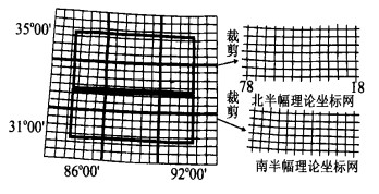
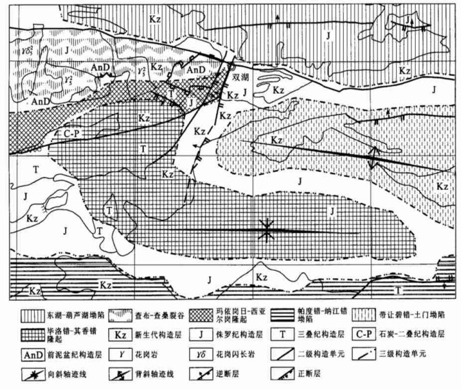
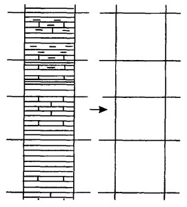
摘要: 新一轮国土资源大调查将全面引入地理信息系统和计算机技术, GIS软件为地质图件数字制图提供了现代化的技术手段, MAPGIS是国产首选GIS软件平台, 具有较强的机助制图功能, 自引入区调工作以来, 已取得了长足的发展.西藏羌塘地区构造复杂, 地质内容丰富, 以该地区1∶50万地质图和1∶100万构造图为例, 阐述了MAPGIS的数字制图技术.重点对数据准备、流程设计、矢量化、坐标网、误差校正、图幅拼接、拓扑造区、线参数编辑、色彩搭配、拷贝技术等进行详细阐述.Abstract: Geographic information system (GIS) and computer techniques will be introduced in the next national land and resources surveying. GIS software will provide modernization techniques with digital mapping of geological maps. MAPGIS, recommended as the first chosen platform of GIS made in China, has a lot of powerful functions of computer-aided mapping. Its application has resulted in considerable progress since it was introduced in regional geological surveying. This paper describs the digital mapping technique with MAPGIS by an example of Qiangtang, Xizang (Tibet), which has complex geological structures and plentiful geological contents, using 1∶500 000 geological map and 1∶1 000 000 structural map of the area. It has given a special account of the data preparing, process design, raster to vector, coordinate grid, error rectification, map junction, topological area creation, line parameter editing, color collocation and copying technology.
-
Key words:
- geographic information system /
- MAPGIS /
- geological map /
- digital mapping
-
表 1 1∶50万地质图图层划分及线参数编辑
Table 1. Dividing o fmap-layer and compiling of line parameter of 1∶500 000 geologica lmap

表 1 1∶50万地质图图层划分及线参数编辑
Table 1. Dividing o fmap-layer and compiling of line parameter of 1∶500 000 geologica lmap
表 2 1∶100万构造图图层划分及线参数编辑
Table 2. Dividing o fmap-layer and compiling of line parameter of 1∶1 000 000 structural map

表 2 1∶100万构造图图层划分及线参数编辑
Table 2. Dividing o fmap-layer and compiling of line parameter of 1∶1 000 000 structural map
表 3 校正前后误差对比
Table 3. Comparison of errors before and after correction

表 3 校正前后误差对比
Table 3. Comparison of errors before and after correction
表 4 1∶50万地质图配色和选色
Table 4. Matching and choosing colors of 1∶500 000 geological map

表 4 1∶50万地质图配色和选色
Table 4. Matching and choosing colors of 1∶500 000 geological map
-
[1] 袁艳斌, 吴冲龙, 李伟忠. 面向野外地质填图的空间实体对象表达[J]. 地球科学——中国地质大学学报, 2001, 26(2): 192-196. https://www.cnki.com.cn/Article/CJFDTOTAL-DQKX200102019.htmYUAN Y B, WU C L, LI W Z. Object styles of spatial entity for field geological mapping based on object-oriented method[J]. Earth Science—Journal of China University of Geosciences, 2001, 26(2): 192-196. https://www.cnki.com.cn/Article/CJFDTOTAL-DQKX200102019.htm [1] 袁艳斌, 吴冲龙, 李伟忠. 面向野外地质填图的空间实体对象表达[J]. 地球科学——中国地质大学学报, 2001, 26(2): 192-196. https://www.cnki.com.cn/Article/CJFDTOTAL-DQKX200102019.htmYUAN Y B, WU C L, LI W Z. Object styles of spatial entity for field geological mapping based on object-oriented method[J]. Earth Science—Journal of China University of Geosciences, 2001, 26(2): 192-196. https://www.cnki.com.cn/Article/CJFDTOTAL-DQKX200102019.htm [2] 张夏林, 汪新庆, 吴冲龙. 计算机辅助地质填图属性数据采集子系统的动态数据模型[J]. 地球科学——中国地质大学学报, 2001, 26(2): 201-204. https://www.cnki.com.cn/Article/CJFDTOTAL-DQKX200102021.htmZHANG X L, WANG X Q, WU C L. Dynamic data model applied in regional geological mapping computer-aided mapping system[J]. Earth Science—Journal of China University of Geosciences, 2001, 26(2): 201-204. https://www.cnki.com.cn/Article/CJFDTOTAL-DQKX200102021.htm [2] 张夏林, 汪新庆, 吴冲龙. 计算机辅助地质填图属性数据采集子系统的动态数据模型[J]. 地球科学——中国地质大学学报, 2001, 26(2): 201-204. https://www.cnki.com.cn/Article/CJFDTOTAL-DQKX200102021.htmZHANG X L, WANG X Q, WU C L. Dynamic data model applied in regional geological mapping computer-aided mapping system[J]. Earth Science—Journal of China University of Geosciences, 2001, 26(2): 201-204. https://www.cnki.com.cn/Article/CJFDTOTAL-DQKX200102021.htm [3] 姜义, 张崇山, 赵洪伟. 1∶5万区域地质调查数字地质图系统设计方案[J]. 中国区域地质, 1998, 17(2): 218-224. https://d.wanfangdata.com.cn/periodical/QK199801119575JIANG Y, ZHANG C S, ZHAO H W. A design scheme of digital system for the production of the 1∶50 000 geological map of regional surveys[J]. Regional Geology of China, 1998, 17(2): 218-224. https://d.wanfangdata.com.cn/periodical/QK199801119575 [3] 姜义, 张崇山, 赵洪伟. 1∶5万区域地质调查数字地质图系统设计方案[J]. 中国区域地质, 1998, 17(2): 218-224. https://d.wanfangdata.com.cn/periodical/QK199801119575JIANG Y, ZHANG C S, ZHAO H W. A design scheme of digital system for the production of the 1∶50 000 geological map of regional surveys[J]. Regional Geology of China, 1998, 17(2): 218-224. https://d.wanfangdata.com.cn/periodical/QK199801119575 [4] 陈克强, 姜义, 李超岭, 等. 计算机辅助编制1∶5万地质图工艺流程研究[J]. 中国区域地质, 1997, 16(1): 66-68. https://www.cnki.com.cn/Article/CJFDTOTAL-ZQYD701.011.htmCHEN K Q, JIAN G Y, LI C L, et al. Technical process research of computer-aided compilation 1∶50 000 geological map of regional surveys[J]. Regional Geology of China. 1997, 16(1): 66-68. https://www.cnki.com.cn/Article/CJFDTOTAL-ZQYD701.011.htm [4] 陈克强, 姜义, 李超岭, 等. 计算机辅助编制1∶5万地质图工艺流程研究[J]. 中国区域地质, 1997, 16(1): 66-68. https://www.cnki.com.cn/Article/CJFDTOTAL-ZQYD701.011.htmCHEN K Q, JIAN G Y, LI C L, et al. Technical process research of computer-aided compilation 1∶50 000 geological map of regional surveys[J]. Regional Geology of China. 1997, 16(1): 66-68. https://www.cnki.com.cn/Article/CJFDTOTAL-ZQYD701.011.htm [5] 郑贵洲, 王琪. 地质图件机助制图相关的几个问题[J]. 地质科技情报, 1997, 16(2): 92-96.ZHENG G Z, WANG Q. Several issues relating to computeraided charting of geologic map[J]. Geological Science and Technology Information, 1997, 16(2): 92-96. [5] 郑贵洲, 王琪. 地质图件机助制图相关的几个问题[J]. 地质科技情报, 1997, 16(2): 92-96.ZHENG G Z, WANG Q. Several issues relating to computeraided charting of geologic map[J]. Geological Science and Technology Information, 1997, 16(2): 92-96. [6] 郑贵洲, 吴信才. MAPGIS图层在地图数据处理和管理中的作用[J]. 测绘学院学报, 2000, 17(3): 216-219. https://www.cnki.com.cn/Article/CJFDTOTAL-JFJC200003018.htmZHENG G Z, WU X C. The action of map-layer on editor and management of map data based on MAPGIS[J]. Journal of Institute of Surveying and Mapping, 2000, 17(3): 216-219. https://www.cnki.com.cn/Article/CJFDTOTAL-JFJC200003018.htm [6] 郑贵洲, 吴信才. MAPGIS图层在地图数据处理和管理中的作用[J]. 测绘学院学报, 2000, 17(3): 216-219. https://www.cnki.com.cn/Article/CJFDTOTAL-JFJC200003018.htmZHENG G Z, WU X C. The action of map-layer on editor and management of map data based on MAPGIS[J]. Journal of Institute of Surveying and Mapping, 2000, 17(3): 216-219. https://www.cnki.com.cn/Article/CJFDTOTAL-JFJC200003018.htm [7] 樊文有, 曾文. GIS制图中标准图框的机助生成[J]. 地球科学——中国地质大学学报, 1998, 23(4): 379-382. doi: 10.3321/j.issn:1000-2383.1998.04.015 FAN W Y, ZENG W. Normal frame computer-aided creation of geographic information system[J]. Earth Science—Journal of China University of Geosciences, 1998, 23(4): 379-382. doi: 10.3321/j.issn:1000-2383.1998.04.015 [7] 樊文有, 曾文. GIS制图中标准图框的机助生成[J]. 地球科学——中国地质大学学报, 1998, 23(4): 379-382. doi: 10.3321/j.issn:1000-2383.1998.04.015 FAN W Y, ZENG W. Normal frame computer-aided creation of geographic information system[J]. Earth Science—Journal of China University of Geosciences, 1998, 23(4): 379-382. doi: 10.3321/j.issn:1000-2383.1998.04.015 -

 下载:
下载:

 点击查看大图

计量
- 文章访问数: 4188
- HTML全文浏览量: 728
- PDF下载量: 20
- 被引次数: 0
