


Research on PRB Digital Mapping Techniques
-
摘要: 从近2 0年地质填图中计算机野外数据采集技术研究的现状和存在的问题入手, 在确定地质填图空间数据表达的基础上, 遵循传统地质填图的规律, 在不约束地质学家地质思维的前提下, 既能满足计算机处理的需要, 又能保证地质工作者取全、取准各项地质观测数据, 在描述各类地质信息空间关系的基础上, 创建了数字地质填图过程标准化和规范化的PRB数字填图技术, 并对构成PRB数字填图技术、PRB数据模型、PRB基本过程、PRB基本过程组合的规则、PRB过程的公共机制、PRB过程基本程式、PRB数据操作、PRB字典、三级PRB体系、PRB数据流“栈”、PRB数据质量定量评价体系的PRB数字填图技术与方法体系进行了讨论.基于该项技术开发的数字填图系统和集GPS一体化的野外数据采集设备已在野外填图中推广应用, 实践效果很好.本文是在实践的基础上, 通过对已有研究资料的进一步分析、总结而完成的.Abstract: To deal with the problems and present situation of field data capture by computer in geological mapping in 20 years, this paper has created PRB digital mapping techniques to standardize the digital mapping process and discussed PRB mapping technique-method system, including PRB digital mapping techniques, the model of PRB data and the related process, combinational regulations of PRB process, common mechanism and basic procedure of PRB process, data processing and dictionary of PRB, three-class PRB system, data flow stack and quantitative evaluation of PRB data. PRB digital techniques, based on establishing the expression of spatial data in mapping, complying with regulations of traditional mapping, and describing the spatial relationships among different kinds of geological information, will not only meet needs of computer operation, but also ensure geologists to collect geological observational data comprehensively and accurately. Meanwhile, they also satisfy the thoughts of geologists.
-
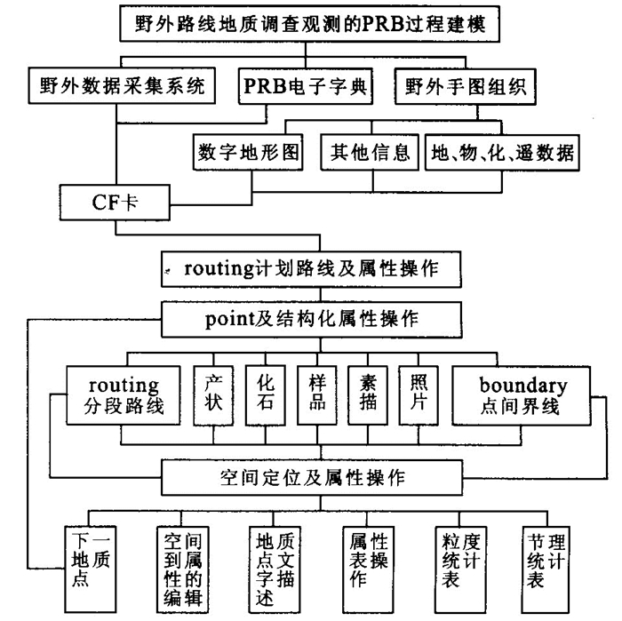
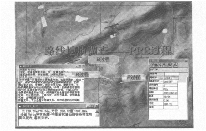
图 1 野外路线地质调查观测的PRB过程建模
Fig. 1. PRB process modeling for field route survey and observation
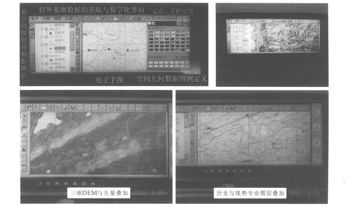
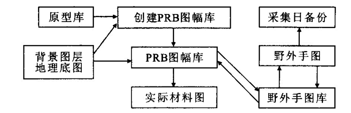
图 4 多源数据的野外手图在野外数据采集器的整合表现
Fig. 4. Concordance of field picked map from multi-source data in field data capture devices
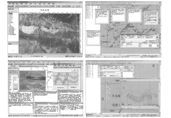
图 5 PRB数据——野外记录、素描、照片数据的交互操作
Fig. 5. Interprocess of PRB data including field records, sketches and photoes
-
[1] Gregory J W. Geological mapping and collection of geological structure data with a GPS receiver and a personal digital assistance (PDA) computer[A]. Digital mapping techniquesʾ99-workshop proceedings[C], 1999. 127- 131. [2] Robert J K, Curtis C A, Daniel O N, et al. Review of digital mapping techniques: the Illinois experience[A]. Digital mapping techniquesʾ97[C]. [s. l. ]: [s. n. ], 1997. [3] Brodaric B. Field data capture and manipulation using GSC Fieldlog v3. 0[A]. In: Soller D R, ed. Digital mapping techniquesʾ97-proceedings of a workshop on digital mapping techniques[C]. [s. l. ]: [s. n. ], 1997. 77-81. [4] Rogers N, Brodaric B. Spatially linked relational database management of petrology and geochemistry using Fieldlog v3. 0: a worked example from the Bathurst mining camp, New Brunswick[R]. Current Research 1996-E, 1996. 255-260. [5] Williams V S, Selner G I, Taylor R B. GSMCAD, a new computer program that combines the functions of the GSMAP and GSMEDIT programs and is compatible with Microsoft Windows and Arc/Info[R]. US Geological Survey Open-File Report 96-007, 1996. 18. [6] Blewett R S, Hazell M S. Digital on-site capture using an Apple Newton palmtop computer[R]. Canberra: Geological Society of Australia Abstracts No. 41, 13th Australian Geological Convention, 1996. [7] Murray H, Richard B. Accurate and efficient capturing of field data for integration into GIS-a digital field NotePad system[A]. In: Forum proceedings of the third national forum on GIS in the geosciences, 19-20 March[C]. AGSO Record, 1997, 36: 90-97. [8] Ryburn R J, Bond L D, Hazell M S. Guide to OZROXAGSOʾs field geology database[M]. [s. l. ]: Australian Geological Survey Organization Record, 1995. 79. [9] Blewett R S, Hazell M. Userʾs guide to MapPad and AGSO Fieldpad for the Apple Newton palmtop computer [M]. [s. l. ]: Australian Geological Survey Organization Record, 1997. 10. [10] Blewett R S. The AGSO field geological notebooks-a userʾs guide[M]. [s. l. ]: Australian Geological Survey Organization Record, 1993. 46. -

 下载:
下载:
 点击查看大图
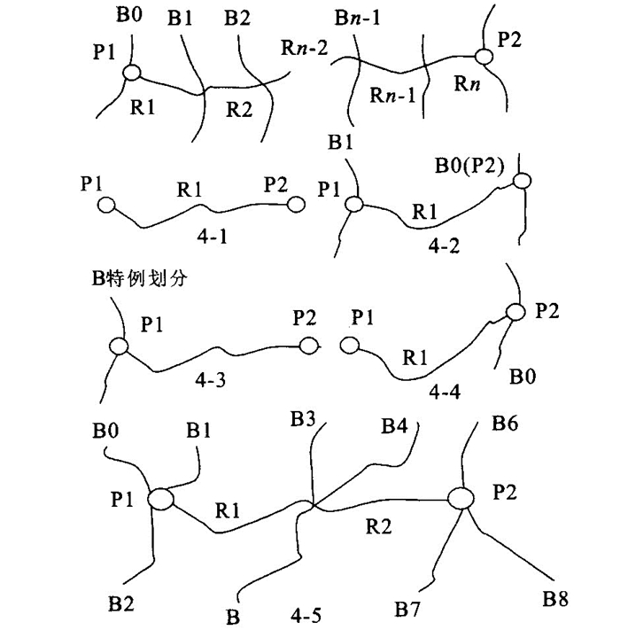
图(6)
计量
- 文章访问数: 4324
- HTML全文浏览量: 948
- PDF下载量: 30
- 被引次数: 0
