


Primary Study on Tectonic Landforms in Northern Part of Middle Himalayan Orogen
-
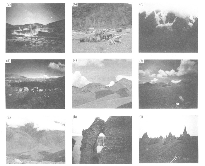
摘要: 研究区位于喜马拉雅造山带中段北坡, 构造地貌丰富、典型.本文在野外调查的基础上, 将区内构造地貌分为断裂构造地貌、花岗岩构造地貌、夷平面构造地貌、冰川构造地貌、水系及阶地构造地貌和土林构造地貌等类型, 并对这些构造地貌特征进行初步分析描述, 为喜马拉雅造山带的构造隆升研究提供了地表构造地貌上的有力信息.Abstract: The study area lying in the north slope of the middle part of Himalayan orogen involves abundant representative tectonic landforms. Based on the field survey, this paper works out several tectonic landforms: faulting landforms, granite landforms, planation surface landforms, glacier landforms, water system, terrace landforms and earth wood landforms. Then it describes and analyzes the characteristics of those tectonic landforms. All these have provided forceful information for the research of Himalaya's tectonic uplifting and its surface landforms.
-
Key words:
- tectonic landform /
- river terrace /
- Himalayan orogen /
- Dingjie area
-
[1] 韩慕康. 构造地貌学[J]. 地球科学进展, 1992, 7 (5): 61-62. https://www.cnki.com.cn/Article/CJFDTOTAL-DXJZ202006005.htmHAN M K. Tectonic geomorphology[J]. Advance in Earth Sciences, 1992, 7 (5): 61-62. https://www.cnki.com.cn/Article/CJFDTOTAL-DXJZ202006005.htm [2] 杜国云, 王竹华, 李晓燕. 构造地貌分析体系及相关的构造地貌标志[J]. 烟台师范学院学报(自然科学版), 2002, 18 (2): 105-112. doi: 10.3969/j.issn.1673-8020.2002.02.008DU G Y, WANG Z H, LI X Y. Analysis system and mark for tectonic geomorphology[J]. Yantai Normal UniversityJ ournal (Natural Science), 2002, 18 (2): 105-112. doi: 10.3969/j.issn.1673-8020.2002.02.008 [3] 吴珍汉, 吴中海, 江万, 等. 中国大陆及邻区新生代构造—地貌演化过程与机理[M]. 北京: 地质出版社, 2001.WU Z H, WU Z H, JIANG W, et al. The Cenozoic evolution and mechanism of tectonic-landforms of China continent and its adjacent areas[M]. Beijing: Geological Publishing House, 2001. [4] Ufimtsev G F. The third face of tectonics—Tectonican alysis of relief[J]. Earth Science Frontiers, 1995, 2 (1-2): 9-18. [5] 李志中. 阿尔金山及其毗邻地区构造地貌的形成和演化[J]. 地理研究, 1994, 13 (3): 35-43. doi: 10.3321/j.issn:1000-0585.1994.03.004LI Z Z. Formation and evolution of the tectonic landforms in the Altun mountain and its neighbouring region[J]. Geographical Research, 1994, 13 (3): 35-43. doi: 10.3321/j.issn:1000-0585.1994.03.004 [6] 赵小麟, 邓起东, 陈社发. 岷山隆起的构造地貌学研究[J]. 地震地质, 1994, 16 (4): 429-439. https://www.cnki.com.cn/Article/CJFDTOTAL-DZDZ404.017.htmZHAO X L, DENG Q D, CHEN S F. Tectonic geomorphology of the Minshan uplift in western Sichuan, southwestern China[J]. Seismology and Geology, 1994, 16 (4): 429-439. https://www.cnki.com.cn/Article/CJFDTOTAL-DZDZ404.017.htm [7] 闫纯有. 邯郸地区地貌与构造[J]. 河北建筑科技学院学报, 2000, 17 (4): 63-65. doi: 10.3969/j.issn.1673-9469.2000.04.018YAN C Y. Landform and structure of Handan area[J]. Journal of Hebei Institute of Architectural Science and Technology, 2000, 17 (4): 63-65. doi: 10.3969/j.issn.1673-9469.2000.04.018 [8] 吴忱. 华北山地水系变迁与新构造运动[J]. 华北地震科学, 2001, 19 (4): 1-6. doi: 10.3969/j.issn.1003-1375.2001.04.001WU C. Changes of river system and new tectonic movement in north China mountainous area[J]. North China Earthquake Sciences, 2001, 19 (4): 1-6. doi: 10.3969/j.issn.1003-1375.2001.04.001 [9] Hodges K V, Parrish R R, Housh T B, et al. Simultaneous Miocene extension and shortening in the Himalayan orogen[J]. Science, 1992, 258: 1466-1469. doi: 10.1126/science.258.5087.1466 [10] Edwards M A, Harrison T M. When did the root collapse Late Miocene north-south extension in the high Himalaya revealed by Th-Pb monazite dating of the Khula Kangri granite[J]. Geology, 1997, 25 (6): 543-546. doi: 10.1130/0091-7613(1997)025<0543:WDTRCL>2.3.CO;2 [11] 中国科学院青藏高原综合科学考察队. 西藏地貌[M]. 北京: 科学出版社, 1983.Team of Chinese Academy of Science of the Scientific Expedition to the Qinghai-Xizang Plateau. Geomorphology of Xizang[M]. Beijing: Science Press, 1983. [12] 钱方, 何培元, 郝治. 花岗岩石林(阿斯哈图)———一种新的地貌景观[J]. 地质力学学报, 2000, 6 (1): 90-94. https://www.cnki.com.cn/Article/CJFDTOTAL-DZLX200001012.htmQIAN F, HE P Y, HAO Z. Granite hoodoos (Arsihaty) —A new geomorphic landscape[J]. Journal of Geomechanics, 2000, 6 (1): 90-94. https://www.cnki.com.cn/Article/CJFDTOTAL-DZLX200001012.htm [13] 王树基. 亚洲中部山地梯级地貌初步研究[J]. 干旱区地理, 1995, 18 (3): 1-7. doi: 10.3321/j.issn:1000-6060.1995.03.001WANG S J. Preliminary study on terraced geomorphy of mountain in the middle of Asia[J]. Arid Land Geography, 1995, 18 (3): 1-7. doi: 10.3321/j.issn:1000-6060.1995.03.001 [14] 中国科学院西藏科学考察队. 朋曲河流域的阶地[A]. 珠穆朗玛峰地区科学考察报告(1966—1968): 现代冰川与地貌[C]. 北京: 科学出版社, 1975.180-190.Team of Chinese Academy of Science of the Scientific Expedition to the Qinghai-Xizang Plateau. Terraces in the area of Pengqu river[A]. The Scientific Expedition Report (1966—1968)on Qomolangma (Everest) area: Modern glacier and geomorphology[C]. Beijing: Science Press, 1975.180-190. -

 下载:
下载:
 点击查看大图
图(1)
计量
- 文章访问数: 4043
- HTML全文浏览量: 565
- PDF下载量: 21
- 被引次数: 0
