


Identification of Mining Pollution Using Hyperion Data at Dexing Copper Mine in Jiangxi Province, China
-
摘要: 利用高光谱图谱结合特征开展矿山污染直接识别研究.首先详细分析了德兴铜矿矿山污染(废矿、废水以及植被) 地物的光谱特征, 总结出可利用于直接识别和提取这些污染物的特征光谱, 从而利用矿区航天Hyperion高光谱数据并以矿物识别谱系技术为主有效地识别出矿区的污染类型及其分布.对于以黄铁矿等含铁矿物为主的围岩或贫矿矿石的氧化污染利用70 0nm、10 0 0nm以及2 2 0 0nm附近的特征吸收分别识别出含Fe3 + 矿物及其Fe2 + 和Fe3 + 混合矿物, 并进一步根据光谱特征识别出赤铁矿和针铁矿; 根据矿区水体在6 0 0nm附近吸收特征的差异相对区分出酸性水、碱性水和中性水; 根据植被在6 85nm附近的最大吸收深度相对地划分植被污染程度.最后建议建立矿山污染地物光谱数据库.该研究为利用高光谱的技术优势快速且有效地直接识别与提取出污染源的种类、类型并分析其潜在的污染趋势提供了新的思路, 为矿山污染监测、治理规划和复垦提供了新技术和知识支撑.Abstract: The process of contamination identification at Dexing copper mine based on the spectral feature of pollutions such as mine offal, waste water and vegetation and so on are investigated using spectral identification tree technique for Hyperion data. The spectra of various surface materials at mine are analyzed at first. And then the different contaminations, the Fe-bearing minerals including Fe3+ and mixture of Fe2+ and Fe3+ based on the spectral absorption feature of 700 nm, 1 000 nm and 2 200 nm, the pollution water and their relative pH based on the spectral feature of 600 nm, the vegetation contamination caused by mine offal and pollution water based on the maximum absorption of spectral depth between 580 nm-750 nm, are identified and extracted using Hyperion data. The spectral database of mining pollution is proposed. A good idea of identifying mining pollution quickly and directly is put forward using hyperspectral imaging technique. The project can be very practical in terms of technical support for inspecting and surveying, managing and planning, remedial action of mine environment.
-
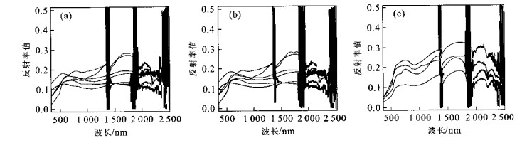
图 2 废弃物光谱特征
a.新鲜岩石, 表面颜色灰色; b.弱风化, 表面颜色黄色; c.强氧化, 表面颜色棕红色
Fig. 2. Spectra of mining offal
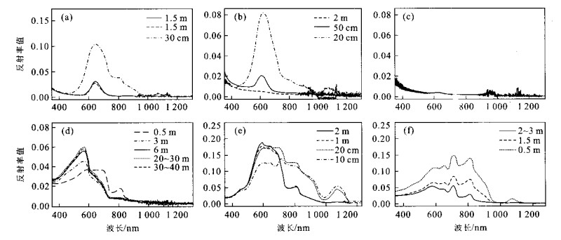
图 3 水体光谱特征
图中数字表示测试处离岸距离; a—c.酸性水体光谱特征; d.碱性水体光谱特征; e.大坞河河水; f.乐安河河水
Fig. 3. Spectra of water from mine
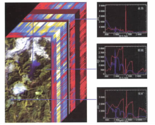
图 5 矿区部分高光谱Hyperion影像图(左) 及其辐射校正前后光谱对比(右)
影像波谱中, 蓝色表示校正前; 红色表示校正后
Fig. 5. Hyperion data cube (left) and spectral comparisons between row and recorrected data (right)
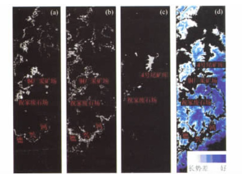
图 6 矿山污染信息(a-c: 灰白色) 提取
a.三价铁化合物; b.含Fe2+与Fe3+混合矿物; c.水域; d.植被污染
Fig. 6. Contamination information (gray in image of a-c) identification and extraction of mine
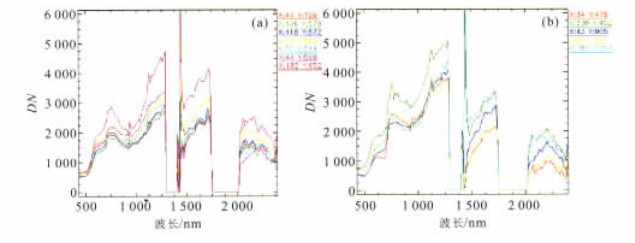
图 7 所识别铁矿物的图像波谱
a.三价铁化合物; b.Fe2+与Fe3+的混合矿物; X, Y为影像像元坐标
Fig. 7. Spectra of identified Fe-bearing mineral from image cube

图 8 MNF B1与MNF B6散点图(a)、水体酸碱度信息(b) 与水体影像光谱(c) (c图不同颜色所表示的影像光谱与b图地物对应)
Fig. 8. Relative pH information segmenting of water: scatterplot between MNF B1 and MNF B6 (a), relative pH for various water (b. red shows relative low pH; blue shows relative middle pH and green shows relative high pH) and spectra corresponding to different pH water (c)
-
Acron, 2003. http://www.aigllc.com/acron/intro.asp. Clark, N. R., 1999. Spectroscopy of rocks and minerals, and principles of spectroscopy. http://speclab.cr.usgs.gov(lastrevisedonJune25, 1999). Gan, F. P., Wang, R. S., Ma, A. N., 2003a. Spectral identificationtree (SIT) for mineral extraction using AVIRIS data. Proceedings of SPIE, 4897: 203-210. doi: 10.1117/12.466877 Gan, F. P., Wang, R. S., Ma, A. N., 2003b. Spectral identification tree (SIT) for mineral extraction based on spectral characteristic of mineral. Earth Science Frontiers, 10 (2): 445-454 (in Chinese with English abstract). Green, A. A., Berman, M., Switzer, P., et al., 1988. A transformation for ordering multispectral data in terms of image quality with implications for noise removal. IEEE Trans. Geosci. Remote Sens., 26 (1): 65-74. doi: 10.1109/36.3001 Hoque, E., Huntzler, J. S., 1992. Spectral blue-shift of red edge monitors damage class of beech trees. Remote Sensing of Environment, 39: 81-84. doi: 10.1016/0034-4257(92)90142-7 Jago, A. R., Cutler, M. E. J., Curran, P. J., 1999. Estimating canopy chlorophyll concentration from field and airborne spectra. Remote Sensing of Environment, 68: 217-224. doi: 10.1016/S0034-4257(98)00113-8 Krue, F. A., 1996. Mineral mapping for environmental hazards assessment using AVIRIS data, Leadville, Colorada, USA. Presented at the eleventh thematic conference and workshops on applied geologic remote sensing, Las Vegas, Nevada, 27-29February, 1996, Ⅱ-526-Ⅱ-533. Liao, L., JarEckc, P., Glcichauf, D., et al., 2000. Performance characterization of the Hyperion imaging spectrometer instrument. Proceedings of SPIE, 4135: 264-275. doi: 10.1117/12.494253 Lu, L., Wang, R. C., Xue, J. C., et al., 2002. Secondary surficial color of pyrite: An indicator of oxidation degree. Acta Mineralogica Sinica, 22 (3): 211-216 (in Chinese with English abstract). Mars, J. C., Crowley, J. K., 2003. Mapping mine wastes and analyzing areas affected by selenium-rich water runoff southeast Idaho using AVIRIS imagery and digital elevation data. Remote Sensing of Environment, 84: 422-436. doi: 10.1016/S0034-4257(02)00132-3 MINEO, 2002. Minitoring and assessing the environment impact of mining in Europe using advance earth observation techniques. http://www.brgm.fr/mineo. Ribeiro, M. N. C., Carvalho, J. O. A., Guimarães, E. M., et al., 2000. Integral spectral analysis (ISA) applied to AVIRIS data for manganese mineralized laterites in SãoJoão da Alianaa/GO, Brazil. Ninth JPL airborne visible/infrared imaging spectrometer (AVIRIS) workshop. JPL Publication, 10-18. Swayze, G. A., Smith, K. S., Clark, R. N., et al., 2000. Using imaging spectroscopy to map acidic mine waste. Environmental Science and Technology, 34: 47-54. doi: 10.1021/es990046w Wu, F., 2000. Wastewater treatment situations and its future at Dexing copper mine. Copper Mining Engineering, 1: 27-29 (in Chinese with English abstract). Zhao, D. Z., Liu, Y. J., 2001. The spectral feature of pollution water in China. Ocean Press, Beijing (in Chinese). Zhu, X., Huang, C. K., Rui, Z. Y., et al., 1981. The geology of Dexing porphyry copper ore field. Geological Publishing House, Beijing (inChinese). 甘甫平, 王润生, 马蔼乃, 2003. 基于特征谱带的高光谱遥感矿物谱系识别. 地学前缘, 10 (2): 445-454. doi: 10.3321/j.issn:1005-2321.2003.02.024 卢龙, 王汝成, 薛纪成, 等, 2002. 黄铁矿表面次生色: 氧化程度的标志. 矿物学报, 22 (3): 211-216. doi: 10.3321/j.issn:1000-4734.2002.03.005 吴飞, 2000. 德兴铜矿矿山废水治理现状及其前景. 铜业工程, 1: 27-29. https://www.cnki.com.cn/Article/CJFDTOTAL-TYGC200001007.htm 赵冬至, 刘玉机, 2001. 中国污染水体光谱特征. 北京: 海洋出版社. 朱训, 黄崇轲, 芮宗瑶, 等, 1981. 德兴斑岩铜矿. 北京: 地质出版社. -

 下载:
下载:
 点击查看大图

计量
- 文章访问数: 4581
- HTML全文浏览量: 702
- PDF下载量: 22
- 被引次数: 0
