


Theory and Method Problems of Informatization of Geological Surveying and Mineral Resource Exploration
-
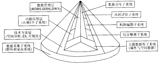
摘要: 实现地矿勘查工作信息化的有效途径与方法是根据地矿勘查工作自身的特点, 建立以主题式地矿点源数据库(包括空间数据库和属性数据库)为基础的共用数据平台; 利用信息系统技术对地矿勘查工作主流程进行充分改造, 实现全程计算机辅助化; 进行“多S”的技术集成、网络集成、数据集成和应用集成, 同时实现勘查数据的三维可视化.为此, 需要加强地质信息科学和地矿勘查工作信息化的理论框架、技术体系和方法论研究, 重视与地矿勘查工作相适应的集成化信息技术开发.Abstract: The effective approaches of improving the level of information technology application in geological surveying and mineral resource exploration are: (1) A common data platform should be established based on subject geological and mineral point-source resource databases (including spatial databases and attribute databases) according to the character of the work itself; (2) The main flow of geological surveying and mineral resource exploration can be rebuilt by making use of information system technology to put the computer-aided whole working flow into practice; (3) The "multi-S" system integration such as technical integration, network integration, data integration and application integration should be carried out, and meanwhile 3D visualization of exploration data can be realized. Therefore, it is important that the research into the theory framework, methodology and technological systems in consolidating data from geological surveying and mineral resource exploration should be taken seriously and enhanced.
-
Harbaugh, J. W., Bonham Carter, G., 1980. Computer simulation in geology. Wiley Interscience, New York. Hou, J. R., Huang, J. X., 1990. Theory and methods of geological statistics. Geological Publishing House, Beijing (in Chinese). James, M., 1977. Computer database organization. Second Edition. Prentice HallPTR, NJ, USA. Li, D. R., 1995. Discussion on combination of globe positioning system (GPS), digital photograph system (DPS), remote sensing (RS), geographical information system (GIS) and expert system (ES). In: Du, D. S., ed., Integration and application of GPS, RS, GIS. Wuhan Technical University of Surveying and Mapping Press, Wuhan, 200—209 (in Chinese). Li, D. R., 1997. Discussion on definition of integration of GPS, RS and GIS. Journal of Remote Sensing, 1(1): 64—68 (in Chinese with English abstract) Li, J., 2001. Research on visualization of GIS decision support: [Dissertation]. Wuhan University, Wuhan (in Chinese with English abstract). Liu, G., Han, Z. J., Luo, Y. J., et al., 2001. Research into application frame work of para metric design method of computer-aided map generation in resources exploration information system. Earth Science—Journal of China University of Geosciences, 26(2): 197—200 (in Chinese with English abstract) Liu, G., Wang, X. Q., Li, W. Z., et al., 2002. The structure analysis and development strategy of resources exploration map computer-aided design system. Geologyand Prospecting, 38 (4): 60-63 (in Chinese with English abstract). Liu, G., Wu, C. L., Wang, X. Q., 2003. Research progress of field working system of computer-aided regional geological survey. Advance in Earth Sciences. 18(1): 77-84 (in Chinese with English abstract). Reddy, R. K. T., Bonham-Carter, G. F., Wright, D. F., 1990. GIS for mapping and assessing mineral resource potential; an application to base-metal resource evaluation in Manitoba. In: GIS for the 1990s, National Conference. Canadian Institute of Surveying and Mapping. Canada. 384-400. Williams, F. N., 1996. Three-dimensional subsurface characterization using geoscientific information systems in the Springfield-Harrison 1∶250000 map quadrangles, Missouri and Arkansas. Golden, CO, United States. 200. Wu, C. L., Zhang, H. N., Zhou, J. Y., 1993. The system viewpoint and methodology of basin modeling. Earth Science—Journal of China University of Geosciences, 18(6): 741—747 (in Chinese with English abstract) Wu, C. L., Wang, X. Q., Liu, G., et al., 1996. Geological and mineral resources point-source information system: Design principle and applications. China University of Geosciences Press, Wuhan (in Chinese). Wu, C. L., 1998a. Development and applications of geological and mineral resources point-source information system (GMPIS). Earth Science—Journal of China University of Geosciences, 23 (2): 193-198 (in Chinese with English abstract). Wu, C. L., 1998b. Computing technology in the field of geology and mineral resources. Earth Science Frontiers, 5 (2): 343-355 (in Chinese with English abstract). Wu, C. L., Wang, X. P., Mao, X. P., et al., 2001. Petroleum pool-formation 3D-dynamics modeling and its soft development. Petroleum Geology and Experiment, 23 (3): 301-311 (in Chinese with English abstract). Wu, C. L., Liu, G., 2002. Discussion on methodology of "digital land and resources of China" project. Earth Science—Journal of China University of Geosciences, 27 (5): 605-609 (in Chinese with English abstract). Xu, G. H., Sun, S., Chen, Y. T., et al., 1999. Meeting the challenge of "digital Earth". Journal of Remote Sensing, 3 (2): 85-89 (in Chinese with English abstract). Zhang, H. T., 2001. Serving national aim and incarnating innovation of science and technology. Geologyin China, 28 (1): 4-8 (in Chinese with English abstract). Zhao, P. D., Li, Z. J., Hu, W. L., 1983. Statistical prediction of deposits. Geological Publishing House, Beijing, 10-12 (in Chinese). Zhao, P. D., Meng, X. G., 1992. Quantification problems of geology. Earth Science—Journal of China University of Geosciences, 17 (Suppl.): 51-56 (in Chinese with English abstract). 侯景儒, 黄竟先, 1990. 地质统计学的理论与方法. 北京: 地质出版社. 李德仁, 1995. 论全球定位系统(GPS)、数字摄影测量系统(DPS)、遥感(RS)、地理信息系统(GIS)和专家系统(ES)的结合. 见: 杜道生编, GPS、RS、GIS的集成与应用. 武汉: 武汉测绘科技大学出版社, 200-209. 李德仁, 1997. 论GPS、RS与GIS集成的定义. 遥感学报, 1 (1): 64-68. https://www.cnki.com.cn/Article/CJFDTOTAL-YGXB199701008.htm 李俊, 2001. GIS决策支持可视化的研究[博士学位论文]. 武汉: 武汉大学. 刘刚, 韩志军, 罗映娟, 等, 2001. 资源勘查信息系统中参数化图形设计方法的应用框架研究. 地球科学——中国地质大学学报, 26 (2): 197-200. https://www.cnki.com.cn/Article/CJFDTOTAL-DQKX200102020.htm 刘刚, 汪新庆, 李伟忠, 等, 2002. 资源勘查图件计算机辅助编绘系统的结构分析与开发策略研究. 地质与勘探, 38 (4): 60-63. doi: 10.3969/j.issn.0495-5331.2002.04.013 刘刚, 吴冲龙, 汪新庆, 2003. 计算机辅助区域地质调查野外工作系统研究进展. 地球科学进展, 18 (1): 77-84. doi: 10.3321/j.issn:1001-8166.2003.01.011 吴冲龙, 张洪年, 周江羽, 1993. 盆地模拟的系统观与方法论. 地球科学——中国地质大学学报, 18 (6): 741-747. https://www.cnki.com.cn/Article/CJFDTOTAL-DQKX199306009.htm 赵鹏大, 李紫金, 胡旺亮, 1983. 矿床统计预测. 北京: 地质出版社, 10-12. 吴冲龙, 1998a. 地质矿产点源信息系统的开发与应用. 地球科学——中国地质大学学报, 23 (2): 193-198. https://www.cnki.com.cn/Article/CJFDTOTAL-DQKX802.018.htm 吴冲龙, 1998b. 计算机技术与地矿工作信息化. 地学前缘, 5 (2): 343-355. https://www.cnki.com.cn/Article/CJFDTOTAL-DXQY802.030.htm 吴冲龙, 王燮培, 毛小平, 等, 2001. 三维油气成藏动力学建模与软件开发. 石油实验地质, 23 (3): 301-311. doi: 10.3969/j.issn.1001-6112.2001.03.010 吴冲龙, 刘刚, 2002. 中国"数字国土"工程的方法论研究. 地球科学——中国地质大学学报, 27 (5): 605-609. https://www.cnki.com.cn/Article/CJFDTOTAL-DQKX200205020.htm 徐冠华, 孙枢, 陈运泰, 等, 1999. 迎接数字地球的挑战. 遥感学报, 3 (2): 85-89. https://www.cnki.com.cn/Article/CJFDTOTAL-YGXB902.000.htm 张洪涛, 2001. 服务国家目标, 体现科技创新. 中国地质, 28 (1): 4-8. doi: 10.3969/j.issn.1006-9372.2001.01.002 赵鹏大, 李紫金, 胡旺亮, 1983. 矿床统计预测. 北京: 地质出版社, 10-12. 赵鹏大, 孟宪国, 1992. 地质学的定量化问题. 地球科学——中国地质大学学报, 17 (增刊): 51-56. https://www.cnki.com.cn/Article/CJFDTOTAL-DQKX1992S1008.htm -

 下载:
下载:
 点击查看大图
图(1)
计量
- 文章访问数: 3740
- HTML全文浏览量: 696
- PDF下载量: 10
- 被引次数: 0
