


Application of Digital Aerophotogrammetry in Active Tectonics
-
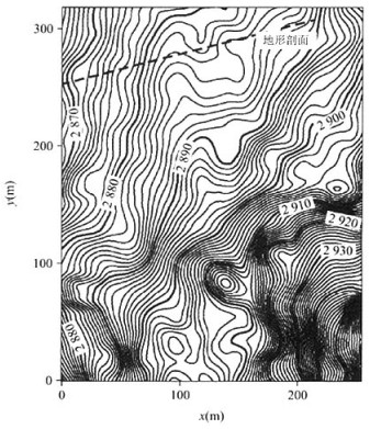
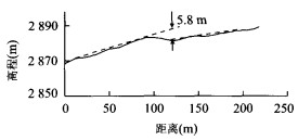
摘要: 为了高效率、高精度地获取活动构造研究中的定量参数, 引入数字航空摄影测量学方法十分必要.在川西地势陡峻的鲜水河断裂带上进行了试验性研究, 探讨了测量精度和效率, 总结了工作流程与操作方法.利用空间信息增强的正射纠正影像、大比例尺地形图和地形剖面图, 获得康定南团结乡附近鲜水河断裂带康定段断层迹线的空间分布, 量测得到该断裂在T1洪积扇形成以来左旋水平位移量为43 m, 垂直位移量为5.8 m.结果表明, 利用数字航空摄影测量学方法进行活动构造地貌研究中水平累积位移量、垂直累积位移量、断层长度等定量参数的测量以及构造几何学精细解析与构造地貌成图完全能满足精度要求, 大大提高了野外工作效率, 是活动构造定量研究的一种有效的技术方法.Abstract: In order to efficiently obtain high-quality quantitative parameters in active tectonics research, it is necessary to introduce digital aerophotogrammetry as a surveying and mapping tool. Testing research was performed along the Xianshuihe fault zone, which is located in the mountain area of western Sichuan Province. Using spatially enhanced, orthorectified images, large scale topography and ground surface profiles, we obtained a series of data of the active Xianshuihe fault zone near Tuanjie in the south of Kangding county. Left lateral horizontal deformation of the fault is about 43 m and vertical deformation is about 5.8 m since the T1 proluvial fan was formed. Digital aerophotogrammetry provides high precision when measuring quantitative parameters in the study of active tectonics such as accumulative horizontal and vertical deformations and fault length, detailed geometric structure resolution and geomorphological mapping, thus greatly improving field work efficiency.
-
Key words:
- digital aerophotogrammetry /
- active tectonics /
- geomorphology /
- surveying and mapping
-
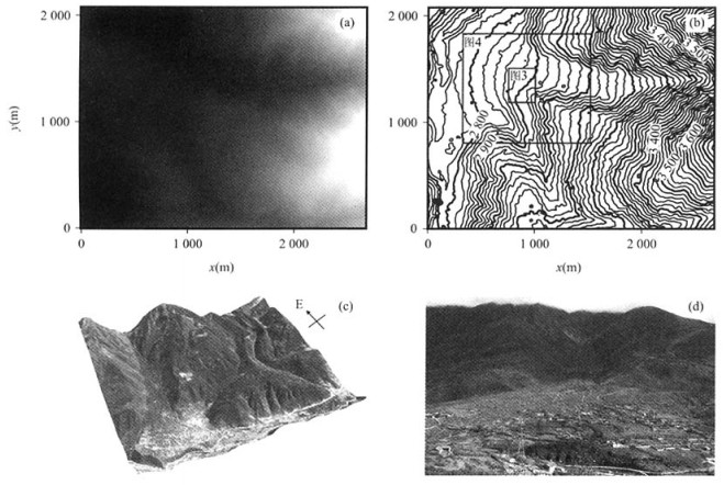
图 2 DEM灰度图(a)、等高线图(b)、正射纠正影像三维立体图(c)和北部洪积扇的实地景观图(d)
Fig. 2. Gray scale DEM(a), contour map(b), orthorectified stereo image(c) and field sight scene of the proluvial fan in the northern part(d)
-
Chen, X. N., Cheng, Y. H., 1998. Analysis of the photograph scanner for digital photogrammetry. Scientific and Technical Communication of Surveying and Mapping, 21(3): 34-37, 33(in Chinese). Deng, Q. D., Chen, L. C., Ran, Y. K., 2004. Quantitative studies and applications of active tectonics. Earth Science Frontiers, 11(4): 383-392(in Chinese with English abstract). Ganas, A., Pavlides, S., Karastathis, V., 2005. DEM-based morphometry of range-front escarpments in Attica, central Greece, and its relation to fault slip rates. Geomorphology, 65(3-4): 301-319. doi: 10.1016/j.geomorph.2004.09.006 Gong, P., 2000. Digital surface model and topographic change monitoring. Quaternary Sciences, 20(3): 247-251(in Chinese with English abstract). doi: 10.3321/j.issn:1001-7410.2000.03.005 Huang, J., 2002. Checking on the quality of DEM. Bulletin of Surveying and Mapping, (2): 55-56(in Chinese with English abstract). Lasserre, C., Morel, P. H., Gaudemer, Y., et al., 1999. Postglacial left slip rate and past occurrence of M≥8 earthquakes on the western Haiyuan fault, Gansu, China. J. Geophys. Res. , 104: 17633-17651. doi: 10.1029/1998JB900082 Riquelme, R., Martinod, J., Hérail, G., et al., 2003. A geomorphological approach to determining the Neogene to recent tectonic deformation in the Coastal Cordillera of northern Chile(Atacama). Tectonophysics, 361(3-4): 255-275. doi: 10.1016/S0040-1951(02)00649-2 Wang, D., 1995. About the mapping precision of aerial photogrammetry. Geotechnical Investigation & Surveying, (6): 42-46, 41(in Chinese with English abstract). Xu, X. W., Wen, X. Z., Zheng, R. Z., et al., 2003. Pattern of latest tectonic motion and its dynamics for active blocks in Sichuan-Yunnan region, China. Science in China(Series D), 46(Suppl. 1): 210-226. doi: 10.1360/03dz0017 Xu, X. W., Yu, G. H., Ma, W. T., et al., 2002. Evidence and methods for determining the safety distance from the potential earthquake surface rupture on active fault. Seismology and Geology, 22(4): 470-483(in Chinese with English abstract). Zhang, J. Q., Pan, L., Wang, S. G., 2003. Photogrammetry. Wuhan University Press, Wuhan(in Chinese). Zhang, S. H., Lü, L. S., Wang, S. J., 2000. Discussion on full digital photogrammetry and 4D product. Remote Sensing In formation, (4): 68-73(in Chinese with English abstract). 陈晓宁, 成燕辉, 1998. 用于数字摄影测量的影像扫描仪剖析. 测绘科技通讯, 21(3): 34-37, 33. https://www.cnki.com.cn/Article/CJFDTOTAL-CHKJ199803010.htm 邓起东, 陈立春, 冉勇康, 2004. 活动构造定量研究与应用. 地学前缘, 11(4): 383-392. doi: 10.3321/j.issn:1005-2321.2004.04.005 宫鹏, 2000. 数字表面模型与地形变化测量. 第四纪研究, 20(3): 247-251. doi: 10.3321/j.issn:1001-7410.2000.03.005 黄健, 2002. 数字高程模型的质量检查. 测绘通报, (2): 55-56. doi: 10.3969/j.issn.0494-0911.2002.02.021 王丹, 1995. 关于航空摄影测量制图的精度问题. 工程勘察, (6): 42-46, 41. https://www.cnki.com.cn/Article/CJFDTOTAL-GCKC506.011.htm 徐锡伟, 闻学泽, 郑荣章, 等, 2003. 川滇地区活动块体最新构造变动样式及其动力来源. 中国科学(D辑), 33(Suppl. 1): 151-162. https://www.cnki.com.cn/Article/CJFDTOTAL-JDXK2003S1016.htm 徐锡伟, 于贵华, 马文涛, 等, 2002. 活断层地震地表破裂"避让带"宽度确定的依据与方法. 地震地质, 22(4): 470-483. doi: 10.3969/j.issn.0253-4967.2002.04.001 张剑清, 潘励, 王树根, 2003. 摄影测量学. 武汉: 武汉大学出版社. 张书煌, 吕良寿, 王苏京, 2000. 全数字摄影测量与4D技术探讨. 遥感信息, (4): 68-73. doi: 10.3969/j.issn.1000-3177.2000.04.024 -

 下载:
下载:

 点击查看大图

图(5)
计量
- 文章访问数: 4234
- HTML全文浏览量: 672
- PDF下载量: 20
- 被引次数: 0
