


3D Complex Geobgical Entity Modeling Method Based on Line-Frame Model
-
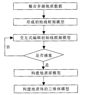
摘要: 提出了一种基于线框架模型的复杂地质体三维建模方法, 在准确表达复杂地质体各要素空间几何形态与相互关系的基础上, 实现地层交错情况下断层面、地层面模型及复杂地质体模型的准确快速构建.建模实践表明: 基于线框架模型的复杂地质体三维建模方法是准确高效的, 能适应常见复杂地质条件下三维复杂地质体模型的构建.Abstract: This paper presents a 3D complex geological entity modeling method based on line-frame model, designed to accurately express the spatial geometrical shape of every element of a complex geological entity and their mutual relationship. This method enables the fast construction of a fault model, stratum model, or complex geological entity model in the case of fault interleaving. Proved in modeling practice, this method is an accurate and effective method for constructing a 3D complex geological entity and it can adapt to constructing 3D geological entity model in the case of familiar complex geological conditions.
-
Key words:
- line-frame model /
- complex geological entity /
- 3D geological modeling
-
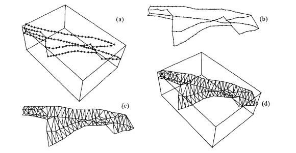
图 4 面模型构建示意
a.断层面的线框架模型; b.参数化后的二维线框架模型; c.二维三角网; d.三维断层面三角网
Fig. 4. Sketch map of constructing face model
-
Alan, M. L., Norman, L. J., 2003. Building solid models from boreholes and user-defined cross-sections. Computers & Geosciences, 29 (3): 547-555. Chen, Y., 2003. Digital photogrammetry of remote sensing image. Tongji University Press, Shanghai (in Chinese). Gong, F. M., 2002.3D geological modeling. Beijing University of Aeronautics and Astronautics[Dissertation], Beijing (in Chinese). Lu, J., 2002. Systematic identification of polyhedral rock blocks with arbitrary joints and faults. Computers & Geotechnics, 28 (1): 49 -72. Michael, S. F., 1997. Parametrization and smooth approximation of surface triangulations. Computer Aided Geometric Design, 14 (3): 231-250. doi: 10.1016/S0167-8396(96)00031-3 Nicolos, E., 1998. A newtool to seal a 3D earth model: A cut with constraints. Gocad meeting, [s. n.]. Sirakov, N. M., Muge, F. H., 2001. A systemfor reconstructing and visualising 3D objects. Computers & Geosciences, 27 (1): 59 -69. Wu, Q., Xu, H., 2005. An effective method for 3D geological modeling with multi-source data integration. Computers & Geosciences, 31 (1): 35 -43. Zehnder, A. T., All mendinger, R. W., 2000. Velocity field for the trishear model. Journal of Structural Geology, 22 (8): 1009 -1014. doi: 10.1016/S0191-8141(00)00037-7 Zhu, L. F., 2005. Research on key technologies of 3D geological modeling basing on GIS[Dissertation]. China University of Geosciences, Wuhan (in Chinese). 陈鹰, 2003. 遥感影像的数字摄影测量. 上海: 同济大学出版社. 宫法明, 2002. 三维地质建模[学位论文]. 北京: 北京航空航天大学. 朱良峰, 2005. 基于GIS的三维地质建模及可视化系统关键技术研究[学位论文]. 武汉: 中国地质大学. -

 下载:
下载:

 点击查看大图
图(5)
计量
- 文章访问数: 4347
- HTML全文浏览量: 591
- PDF下载量: 19
- 被引次数: 0
