


Land Use Planning CAD System Based on GIS
-
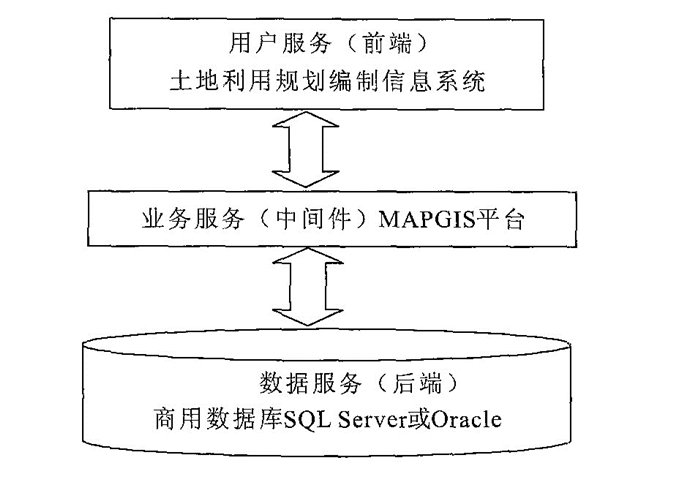
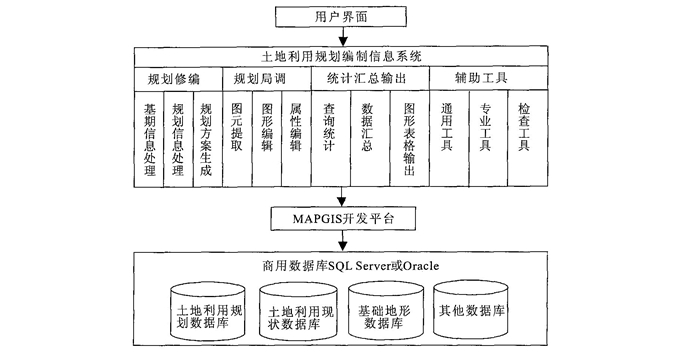
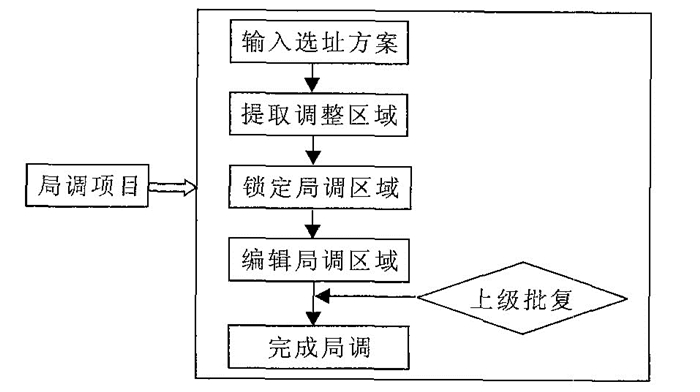
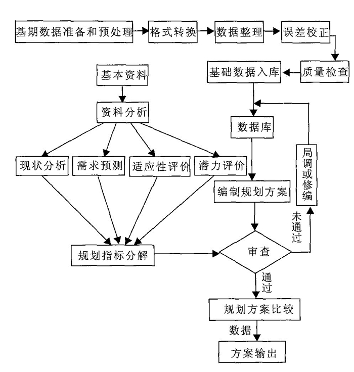
摘要: 土地利用规划方案调整工作过程复杂手、工制作工作量大, 因此传统解决方式只能制作很少的备选方案对相关因素进行定性分析来供领导决策, 以至周期长、风险大; 通过GIS技术将信息化管理引入土地规划编制业务领域, 利用计算机的海量存储能力解决大量规划编制成果的处理问题, 计算机的高速数字化处理能力解决规划方案调整过程中多方案生成与对比的问题, 利用先进的网络技术实现规划指标的动态管理及规划审批的自动规范化管理, 利用GIS技术实现多种专题分析工具, 方便规划因素的定量分析, 达到辅助规划编制的目的.实践表明, 过去需要一个月才能完成的任务现在只需要几天时间并且质量明显好于手工作业方式, 大大提高了工作效率.Abstract: Adjusting land use planning is an important task in land management. Doing so manually provides few options for decision-making, potentially leading to poor decisions. Through using GIS technology, information management is applied in the land use planning field, providing a solution for dealing with land use planning data by making use of modern high computer storage capacity. This paper also presents a way to make and compare multi-schemas in adjusting land use planning by making use of computer data processing.We have achieved a way to dynamically manage land use planning quota by making use of a spatial database and analytical tools for quantitative analysis, improving planning quality and lessening time spent on such projects.
-
Key words:
- planning CAD /
- planning fruit /
- quota /
- adjusting scheme /
- multi-layer analytical tool
-
Land Bureau of Nation, 1997. The collectivity rules of lan dutilizing and planningin county (preview). Land Bureau of Nation, Beijing (in Chinese). Ministry of Land and Resources Planning, 2002. The construct guiding of land utilizing and planning management information systemin county and city (preview). Ministry of Land and Resources, Beijing (in Chinese). Wuhan Zondy Cyber-Tech Co., Ltd., 2001. MAPGIS practical tutorial. Wuhan Zondy Cyber-Tech Co., Ltd., Wuhan (in Chinese). Wuhan Zondy Cyber-Tech Co., Ltd., 2003. Yinzhou collectivity design of land and resources management information system. Wuhan Zondy Cyber-Tech Co., Ltd., Wuhan (in Chinese). Zhang, C., Li, H., Xu, S. W., 2003. Some research on the construction of land utilizing and planning management information system. The Advance of Science and Technology and Countemeasure, 20 (Suppl. ): 103 (in Chinese with English abstract). 国家土地管理局, 1997. 县级土地利用总体规划编制规程(试行). 北京: 国家土地管理局. 国土资源部, 2002. 国土资源信息系统建设规范. 北京: 国土资源部信息中心. 武汉中地数码科技有限公司, 2001. MAPGIS地理信息系统实用教程. 武汉: 武汉中地数码科技有限公司. 武汉中地数码科技有限公司, 2003. 鄞州国土资源管理信息系统总体设计书. 武汉: 武汉中地数码科技有限公司. 张成, 李华, 徐世武, 2003. 土地利用规划管理信息系统建设中的若干问题探讨. 科技进步与对策, 20 (增刊): 103. https://www.cnki.com.cn/Article/CJFDTOTAL-KJJB2003S1099.htm -

 下载:
下载:
 点击查看大图
图(4)
计量
- 文章访问数: 3839
- HTML全文浏览量: 661
- PDF下载量: 22
- 被引次数: 0
