


Extraction of Oil and Gas Haloes Based on ETM+ Data: A Case Study from Yakela, Xinjiang
-
摘要: 在基于单一方法进行油气勘探的过程中, 前人对波段比值的方法给了很高的评价, 但效果均不显著.为了找到一种高效的综合定量分析方法, 根据ETM+ (Enhanced Thematic Mapper Plus) 数据各个波段特征选取ETM753提取构造信息; 在构造控油理论基础上, 对各种比值(如5/1、7/5、7/3、(7-5) / (7+5)等) 分析; 使用标准偏差、相关系数、协方差和特征值对7种波段组合进行了叠加分析, 如[5, NDVI (the Normalized Difference Vegetation Index), 3]、[5, 4, NDVI]、[7, 5, (5/1) ]、[7, 5, (7/1) ]、[7, 5, (7/3) ]、[7, 5, (7/5) ]、[7, 5, (7-5) / (7+5) ]; 最后, 结合构造信息、地质资料等进行综合解译, 发现[7, 5, 7/3]为最佳的波段叠加组合.该方法用于新疆地区雅克拉地区油气晕信息提取效果较好, 同样也可以适用于其他地区.Abstract: Though band ratio is highly evaluated as a single method in oil-gas exploration, the effect is far from satisfactory. To find a highly effective quantitative analysis method, in this paper, the bands 7, 5, 3 are chosen to extract structure information according to specific band characteristics of ETM+ (Enhanced Thematic Mapper Plus) data. Based on structure oil-controlling theory, a series of band ratios (such as 5/1, 7/5, 7/3, (7-5) / (7+5)) is compared. Then, the overlapping analysis of 7 band compositions (5, NDVI (the Normalized Difference Vegetation Index), 3, 5, 4, NDVI, 7, 5, 5/1, 7, 5, 7/1, 7, 5, 7/3, 7, 5, 7/5, 7, 5, (7-5) / (7+5)) are done through standard deviation, correlation coefficient, covariance, eigenvalue. Through the integrated interpretation and combined with geological structure information and geological data, 7, 5, 7 /3 is found to be the best band combination. With this combination method, the extracting of oil and gas halo information in Yakela region of Xinjiang produces satisfactory result, which proves its potential usage in other regions.
-
Key words:
- oil and gas haloes /
- band ratio /
- ETM+data.
-
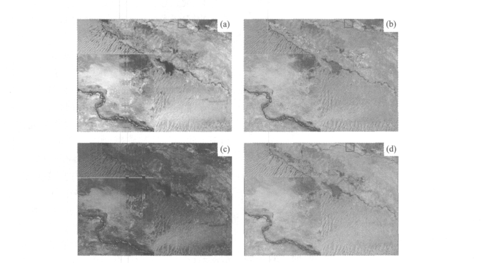
图 2 四种波段叠加图
a.[7, 5, 3]叠加图; b.[7, 5, 7/3]叠加图; c.[5, NDVI, 3]叠加图; d.[7, 5, (7-5) / (7+5) ]叠加图
Fig. 2. Four results of band combination
表 1 3种波段叠加方法中各波段相关系数
Table 1. Correlation of three band compositions

表 2 3种波段叠加方法中各波段特征值及比例
Table 2. Eigenvalue and proportion of three band compositions

表 3 经过比值运算后的复合波段信息
Table 3. Information of complex band ratio

-
Chen, Y. D., 2001. Significance of remote sensingfor directly detecting, selection of TM information and classifying analysisin oil-gas of Chishui, Guizhou Province. Guizhou Geology, 67 (2): 123-127 (in Chinese with English abstract). http://en.cnki.com.cn/Article_en/CJFDTOTAL-GZDZ200102011.htm Chen, Y. D., Yang, H. M., 2001. Analysis of the relationship between pertoleumgeology and oil/gas remote sensing information in Chishui, Guizhou Province. Geology Geochemistry, 29 (1): 68-74 (in Chinese with English abstract). Qian, L. X., 2004. Remote sensing digital i mage processing and geographic characters extraction. Science Press, Beijing, 24-169 (in Chinese). Sherrie, A. P., Mohamed, G. A., 2006. Orbital remote sensingfor geological mapping in southern Tunisia: Implication foroil and gas exploration. Journal of African Earth Sciences, 44 (2): 203-219. doi: 10.1016/j.jafrearsci.2005.10.011 Tan, Q., 2004. Remote sensing prediction technique in oil and gas exploration. Natural Gas Industry, 1 (3): 44-50 (in Chinese with English abstract). http://en.cnki.com.cn/Article_en/CJFDTOTAL-TRQG200403013.htm Wang, G. H., Zhang, Y. Y., Ran, X. Q., 2000. Recent progresses and tendency of remote sensing in hydrocarbon exploration. Earth Science Frontiers, 3 (7): 282-289 (in Chinese with English abstract). http://en.cnki.com.cn/Article_en/CJFDTOTAL-DXQY200003035.htm Weng, Y. L., Tian, Q. J., 2003. Analysis and evaluation of method on remote sensing data fusion. Remote Sensing Information, 1 (3): 49-54 (in Chinese with English abstract). Wu, X. C., Wu, L., 2006. Service-oriented distributed spatialinformation supporting system. Earth Science—Journal of China University of Geosceinces, 31 (5): 585-589 (in Chinese with English abstract). http://en.cnki.com.cn/Article_en/CJFDTOTAL-DQKX200605001.htm Xu, Z. X., Hou, W. G., Su, J. Y., et al., 1999. Systematic research of geophysical and geochemical reservoir anomaliesin Yakela region, Tari m basin, China. China University of Geosciences Press, Wuhan, 63-102 (in Chinese). Yao, J. M., Xia, X. H., Zhang, Y. Y., 2000. Evaluation technique of integrating geochemical prospecting with remote sensingin petroleum exploration. Remote Sensing for Land & Resources, 45 (3): 26-31 (in Chinese with English abstract). http://en.cnki.com.cn/Article_en/CJFDTOTAL-GTYG200003003.htm Yu, W. Y., Qi, X. P., Zou, L. Q., 2000. Evaluation of multi-sensor remote sensing data applied oil and gas explora-tion in the loess highlands, Ordos Plateau, China. Remote Sensing for Land & Resources, 46 (4): 34-39 (inChinese with English abstract). Zhang, B. Z., Zhang, J. X., Zhang, L., 2000. Comparison of multisource images fusion in landuse dynamic detection. Science of Surveying and Mapping, 25 (3): 46-50 (in Chinese with English abstract). http://en.cnki.com.cn/Article_en/CJFDTOTAL-CHKD200003012.htm Zhang, Y. H., Zhao, G. X., Zhao, W. W., 2002. Methods of cultivated land dynamic monitoring by remote sensing technology in counties. Bulletin of Surveying and Mapping, (3): 25-27 (in Chinese with English abstract). 陈佑德, 2001. 赤水油气遥感直接探测意义与TM选择及分类分析. 贵州地质, 67 (2): 123-127. doi: 10.3969/j.issn.1000-5943.2001.02.012 陈佑德, 杨慧民, 2001. 赤水石油地质条件与油气遥感信息关系分析. 地质地球化学, 29 (1): 68-74. doi: 10.3969/j.issn.1672-9250.2001.01.013 钱乐祥, 2004. 遥感数字影像处理与地理特征提取. 北京: 科学出版社, 24-169. 谭青, 2004. 油气勘探中的遥感预测技术. 天然气工业, 1 (3): 44-50. doi: 10.3321/j.issn:1000-0976.2004.03.013 王桂宏, 张友炎, 冉新全, 2000. 油气勘探中遥感方法新进展与趋向. 地学前缘, 3 (7): 282-289. https://www.cnki.com.cn/Article/CJFDTOTAL-DXQY200003035.htm 翁永玲, 田庆久, 2003. 遥感数据融合方法分析与评价综述. 遥感信息, 1 (3): 49-54. doi: 10.3969/j.issn.1000-3177.2003.03.015 吴信才, 吴亮, 2006. 面向服务的分布式空间信息支撑平台. 地球科学——中国地质大学学报, 31 (5): 585-589. https://www.cnki.com.cn/Article/CJFDTOTAL-DQKX200605001.htm 徐忠祥, 侯卫国, 苏江玉, 等, 1999. 塔里木盆地雅克拉地区油气地球物理地球化学异常系统研究. 武汉: 中国地质大学出版社, 63-102. 姚俊梅, 夏响华, 张友焱, 2000. 油气勘探中的化探遥感综合评价技术. 国土资源遥感, 45 (3): 26-31. https://www.cnki.com.cn/Article/CJFDTOTAL-GTYG200003003.htm 于五一, 齐小平, 邹立群, 2000. 多源遥感数据在鄂尔多斯盆地黄土塬油气勘探应用中的评价. 国土资源遥感, 46 (4): 34-39. doi: 10.3969/j.issn.1001-070X.2000.04.007 张炳智, 张继贤, 张丽, 2000. 土地利用动态遥感监测中多源遥感影像融合方法比较研究. 测绘科学, 25 (3): 46-50. https://www.cnki.com.cn/Article/CJFDTOTAL-CHKD200003012.htm 张银辉, 赵庚星, 赵文武, 2002. 县级耕地遥感动态监测方法研究. 测绘通报, (3): 25-27. doi: 10.3969/j.issn.0494-0911.2002.03.010 -

 下载:
下载:
 点击查看大图

计量
- 文章访问数: 3885
- HTML全文浏览量: 984
- PDF下载量: 53
- 被引次数: 0
