


Extraction of Remote Sensing Alteration Information in Tuotuohe, Qinghai Province
-
摘要:
青海沱沱河位于西南“三江”成矿带的西北端, 具有优越的成矿地质背景和巨大成矿潜力, 已发现一批大中型以上规模的铅、锌、银、铜找矿靶区.沱沱河地区属于高寒区, 野外地质工作难于开展, 因此在该地区开展遥感找矿的研究是一种经济、便捷、有效的勘查手段.在ENVI软件的支持下, 根据与蚀变矿物组合相关的波谱特征, 利用掩膜+主成分分析+色度调整(MPH) 的方法从TM多光谱影像中提取与金属矿化有关的铁染与羟基蚀变遥感信息异常, 并结合地质资料, 区划成矿远景区和圈定找矿靶区, 取得了很好的应用效果.
Abstract:Tuotuohe is located at the north-west section of "Sanjiang" metallogenic belt, Qinghai Province.This area boasts favorable mineralization background and great ore mineral potential.Prospecting targets for large-and/or middle-sized lead, zinc, sliver, and copper deposits have been delineated.Tuotuohe area belongs to cold grassy highland where some of the traditional geological field survey and mapping are difficult to conduct.Remote sensing technology is expected to provide low cost and efficient means to facilitate mineral exploration.Based on the spectrum information of mineral associations involved in mineralization-associated alteration zones and with the support of ENVI software, the authors used an integrated masking-principal component analysis-histogram classification (MPH) method to process the TM multi-spectral image to extract patterns related to iron stained alteration and hydroxyl alteration of mineralization form.Geological data are integrated with the results of remote sensing image processing to divide prospective districts and delineate prospecting targets.
-
Key words:
- MPH /
- main component analysis /
- iron stained alteration /
- hydroxyl alteration /
- Tuotuohe
-
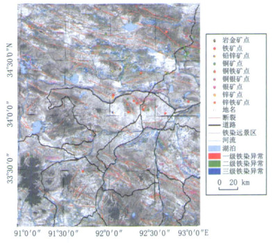
图 2 沱沱河地区铁染蚀变异常分布
Fig. 2. Distribution of iron stained alteration anomaly in Tuotuohe area
-
Abrams, M. J., Ashley, R. P., Brown, L. C., et al., 1977. Mapping of hydrothermal alteration in the Cuprite mining district, Nevada, using aircraft scanner images for the spectral region 0.46 to 2.36μm. Geology, (5): 713-718. https://pubs.geoscienceworld.org/gsa/geology/article-abstract/5/12/713/195297/Mapping-of-hydrothermal-alteration-in-the-Cuprite Cheng, Q. M., 1997. Fractal/multifractal modeling and spatial analysis. In: Pawlowsky-Glahn, V., ed., Keynote Lecture in Proceedings of the International Mathematical Geology Association Conference, Barcelona, Spain, 22-27, 57-72. Cheng, Q. M., 1999. Multifractality and spatial statistics. Computers & Geosciences, 25(9): 949-961. doi: 10.1016/S0098-3004(99)00060-6 Cheng, Q. M., Jing, L. H., Panahi, A., 2006. Principal component analysis with optimum order sample correlation coefficient for image enhancement. International Journal of Remote Sensing, 27(15-16): 3387-3401. doi: 10.1080/01431160600606882 Crosta, A., Moore, J. M., 1989. Enhancement of Landsat thematic mapper imagery for residual soil mapping in SW Minais Gerais State, Brazil: A prospecting case history in Greenstone belt terrain. In: Proceedings of the 7th ERIM Thematic Conference. Remote Sensing for Exploration Geology, 1173-1187. Crowley, J. K., Hubbard, B. E., Mars, J. C., et al., 2003. Hydrothermal alteration on the cascade stratovolcanoes: A remote sensing survey. Geological Society of America Abstracts with Programs, 35(6): 552. He, G. J., Hu, D. Y., Chen, Z. J., et al., 1995. Extracting gold mineralized information directly from TM image. Remote Sensing Technology and Application, 10(3): 51-54(in Chinese with English abstract). Hunt, G. R., Salisbury, J. W., Lenhoff, C. J., 1971. Visible and near-infrared spectra of minerals and rocks: Ⅲ, oxides and hydroxides. Modern Geology, 2(3): 195-205. https://www.semanticscholar.org/paper/Visible-and-near-infrared-spectra-of-minerals-and-Hunt-Salisbury/dcdde7d39320ea0c9d87a954f405388818c3b763 Institute of Information of the Former Department of Geology, ed., 1980. Remote sensing special-Mineral and rock' s visible & mid-infrared spectra and their application. Geological Publishing House, Beijing(in Chinese). Jing, F., Chen, J. P., 2005. The review of the alteration information extraction with remote sensing. Remote Sensing In formation, (2): 62-65, 57(in Chinese with English abstract). Liu, C., Wang, D. L., Li, X. M., 2003. Extracting clay alteration information of medium vegetation covered areas based on linear model of spectral mixture analysis. Remote Sensing Technology and Application, 18(2): 95-98(in Chinese with English abstract). http://en.cnki.com.cn/Article_en/CJFDTOTAL-YGJS200302008.htm Liu, Q. S., Yan, S. X., Ma, C. F., et al., 1999. Remote sensing extraction of piedmont potassic alteration zone in Hadamengou gold deposit district, Inner Mongolia Autonomous region. Remote Sensing Technology and Application, 14(3): 7-11(in Chinese with English abstract). Liu, S. H., Ma, J. W., Lin, Q, Z., 2000. Depicting the hydrothermal alterations of high mountains in multi-spectral data via Gram-Schmidt projection method. Geology and Prospecting, 36(5): 62-65(in Chinese with English abstract). Loughlin, W. P., 1991. Principal component analysis for alteration mapping. Photogrammetric Engineering and Remote Sensing, (57): 1163-1169. Ma, J. W., 1997. Methodology study of quickly identifying mineral bearing alterations from TM data. Journal of Remote Sensing, 1(3): 208-213(in Chinese with English abstract). Pan, T., Luo, C. R., Yi, Y. C., et al., 2006. The prospecting potential and metallogenic rules of metallic ore resources in Qinghai Province. Geological Publishing House, Beijing, 35-37(in Chinese). Rowan, L. C., Goetz, A. F. H., Ashley, R. P., 1977. Discrimination of hydrothermally altered and unaltered rocks in visible and near infrared multispectral images. Geophysics, 42(3): 522-535. doi: 10.1190/1.1440723 Rutz-Armenta, J. R., Prol-Ledesma, R. M., 1998. Techniques for enhancing the spectral response of hydrothermal alteration minerals in thematic mapper images of Central Mexico. International Journal of Remote Sensing, 19 (10): 1981-2000. doi: 10.1080/014311698215108 Song, M. H., Pan, J., Xing, L. X., 2006. The remote-sensing study of metallogenic prognosis in the Qimantage region, eastern Kunlun. Journal of Jilin University (Earth Science Edition), 36(Suppl. ): 210-213(in Chinese with English abstract). Tangestani, M. H., Moore, F., 2001. Comparison of three principal component analysis techniques to porphyry copper alteration mapping: A case study, Meiduk area, Kerman, Iran. Canadian Journal of Remote Sensing, 27 (2): 176-182. doi: 10.1080/07038992.2001.10854931 Yi, P. Q., Wang, Y. K., Gu, Y., 2007. Preliminary research on metallogenic rules of polymetallic in Tuotuohe region, Qinghai Province. Qinghai Guotu Jinglüe, (1): 35 -38(in Chinese with English abstract). Zhang, Y. F., Wu, J. S., 1999. Extraction of mineralization and alteration information from remote sensing images. Geological Exploration for Non-Ferrous Metals, 8(6): 604-606(in Chinese with English abstract). Zhao, Y. H., Zhang, F. X., Chen, N. F., 1991. The application of principal component integration of band ratios to extracting hydrothermal alteration information. Remote Sensing for Land & Resources, (3): 12-17(in Chinese with English abstract). https://oversea.cnki.net/kcms/detail/detail.aspx?dbcode=CJFD&dbname=CJFD1991&filename=GTYG199103002 地质部情报研究所, 1980. 遥感专辑—矿物岩石可见光-中红外光谱及其应用. 北京: 地质出版社. 何国金, 胡德永, 陈志军, 等, 1995. 从TM图像中直接提取金矿化信息. 遥感技术与应用, 10(3): 51-54. https://www.cnki.com.cn/Article/CJFDTOTAL-YGJS503.007.htm 荆凤, 陈建平, 2005. 矿化蚀变信息的遥感提取方法综述. 遥感信息, (2): 62-65, 57. doi: 10.3969/j.issn.1000-3177.2005.02.016 刘成, 王丹丽, 李笑梅, 2003. 用混合像元线性模型提取中等植被覆盖区的粘土蚀变信息. 遥感技术与应用, 18(2): 95-98. doi: 10.3969/j.issn.1004-0323.2003.02.008 刘庆生, 燕守勋, 马超飞, 等, 1999. 内蒙哈达门沟金矿区山前钾化带遥感信息提取. 遥感技术与应用, 14(3): 7-11. doi: 10.3969/j.issn.1004-0323.1999.03.002 刘素红, 马建文, 蔺启忠, 2000. 通过Gram-Schmidt投影方法在高山区提取TM数据中含矿蚀变带信息. 地质与勘探, 36(5): 62-65. doi: 10.3969/j.issn.0495-5331.2000.05.017 马建文, 1997. 利用TM数据快速提取含矿蚀变带方法研究. 遥感学报, 1(3): 208-213. https://www.cnki.com.cn/Article/CJFDTOTAL-YGXB199703007.htm 潘彤, 罗才让, 伊有昌, 等, 2006. 青海省金属矿产成矿规律及成矿预测. 北京: 地质出版社, 35-37. 宋明辉, 潘军, 邢立新, 2006. 东昆仑祁漫塔格地区找矿预测遥感研究. 吉林大学学报(地球科学版), 36(增刊): 210-213. https://www.cnki.com.cn/Article/CJFDTOTAL-CCDZ2006S1047.htm 易平乾, 汪元奎, 顾瑛, 2007. 沱沱河地区多金属成矿规律初步探讨. 青海国土经略, (1): 35-38. doi: 10.3969/j.issn.1671-8704.2007.01.011 张远飞, 吴健生, 1999. 基于遥感图像提取矿化蚀变信息. 有色金属矿产与勘查, 8(6): 604-606. https://www.cnki.com.cn/Article/CJFDTOTAL-YSJS199906063.htm 赵元洪, 张福祥, 陈南峰, 1991. 波段比值的主成分复合在热液蚀变信息提取中的应用. 国土资源遥感, (3): 12-17. https://www.cnki.com.cn/Article/CJFDTOTAL-GTYG199103002.htm -

 下载:
下载:
 点击查看大图
计量
- 文章访问数: 3873
- HTML全文浏览量: 565
- PDF下载量: 55
- 被引次数: 0
