


Integrated Mode and Key Technique of Quantificational Expressing for Mineral Resource Prospecting
-
摘要:
矿产资源勘查的目的是系统地了解矿产资源的赋存情况, 以进一步支持资源评价和生产.在这一过程中, 数据的分析与处理可以全面借助信息技术来提高其效率与质量.通过分析矿产资源勘查信息处理过程和当前发展现状, 认为可以通过数据管理、三维可视化和虚拟现实这3个环节对矿产资源勘查信息处理的全程进行系统集成, 并就其中的关键问题进行比较详细的分析, 提出了一种新的三维数据组织方式和一种基于上述3个环节的系统表达地质实体的新方法, 并应用于多项勘查工作中, 取得了良好的效果.
Abstract:Mineral resource prospecting aims at providing sufficient information on mine state for further resource evaluation and production.In this process, the information technique can be utilized to increase the efficiency and quality of data analysis and processing.In this paper, the authors consider that data management and three dimensional model and virtual reality are three pivotal taches of information processing, by which we can systematically integrate the information technique for mineral resource prospecting.And the authors put forward a new 3D data structure and a new systematic method for expressing geological solid, which have already been successfully applied to multi-resource perambulation work.
-
Key words:
- mineral resource prospecting /
- geological solid /
- 3D data structure
-
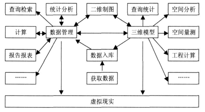
图 1 矿产资源勘查信息处理流程中的3个技术处理中心
Fig. 1. Three information processing centers for mineral resource prospecting
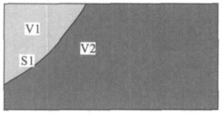
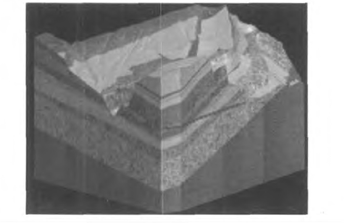
图 5 用S1面剪切原始体得到V1和V2两个体
Fig. 5. V1 and V2 obtainted by surface S1 cutting original object
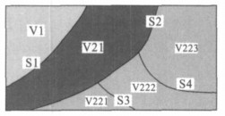
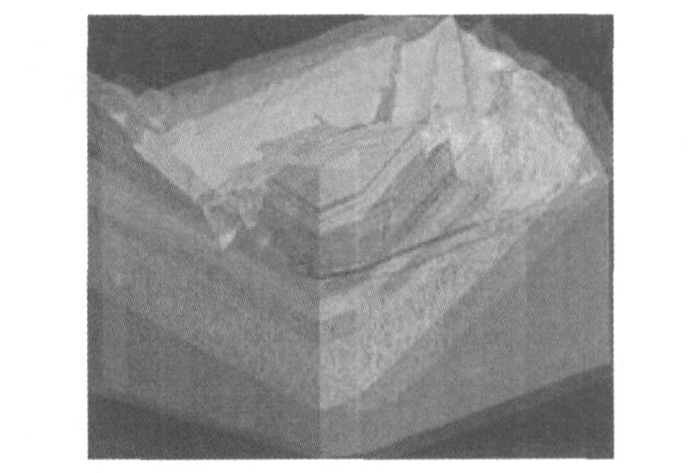
图 6 用S2, S3等面切割体V2的剖面示意图
Fig. 6. The section sketch map of cutting the object V2 by using surfaces S2, S3 and so on
-
Bastante, F. G., Taboada, J., Alejano, L. R., et al., 2005. Evaluation of the resources of a slate deposit using indicator Kriging. Engineering Geology, 81 (4): 407-418. doi: 10.1016/j.enggeo.2005.08.003 Buchele, S. F., Crawford, R. H., 2004. Three-dimensional half space constructive solid geometry tree construction from implicit boundary representations. Computer-Aided Design, 36 (1115): 1063-1073. https://www.deepdyve.com/lp/association-for-computing-machinery/three-dimensional-halfspace-constructive-solid-geometry-tree-Rqn0kVowME Cervera, E., Trevelyan, J., 2005. Evolutionary structural optimisation based on boundary representation of NURBS. Part Ⅱ: 3D algorithms. Computers & Structures, 83 (23-24): 1917-1929. Du, D. S., 1995. Integration and application of GPS and RSand GIS. Wuhan Technical University of Surveying andMapping Press, Wuhan, 200-209 (in Chinese). Elber, G., Shapiro, V., 2004. Editorial to special issue on solid modeling theory and applications. Computer-Aided Design, 36 (1115): 1011-1012. https://www.researchgate.net/publication/220583810_Editorial_to_special_issue_on_solid_modeling_theory_and_applications Fang, X. F., 2007.3D simulation designing system for urban planning based on virtual reality. Computer Simulation, 24 (3): 230-234, 285 (in Chinese with English abstract). Fleisig, R. V., Spence, A. D., 2005. Techniques for accelerating B-Rep based parallel machining simulation. Computer-Aided Design, 37 (12): 1229-1240. doi: 10.1016/j.cad.2004.11.008 Hou, Q., Chen, X. W., 2007. Simulation about liquid based on OpenGL. Application Research of Computers, 24 (2): 186-188 (in Chinese with English abstract). Li, D. R., 1997. On definition, theory and key technics of the integration of GPS, RS and GIS. Journal of Remote Sensing, 1 (1): 64-68 (in Chinese with English abstract). https://en.cnki.com.cn/Article_en/CJFDTOTAL-YGXB199701008.htm Lions, J. L., Pironneau, O., 1999. Domain decomposition methods for CAD. Comptes Rendus de I'Académie des Sciences-Series Ⅰ-Mathematics, 328 (1): 73-80. Liu, J. Q., 2007. Research and application in 3D information system of water conservancy and electricity engineering geology (Dissertation). China University of Geosciences, Wuhan (in Chinese with English abstract). Liu, J. Q., Huang, C. Q., Wu, C. L., 2007. Management strategy and realized methods for geological information of Yangtze River embankment engineering. Journal of Yangtze River Scientific Research Institute, 24 (4): 38-41 (in Chinese with English abstract). Liu, J. Q., Zhou, X. Z., Wu, C. L., et al., 2008. The problem of technology integrated to process geological information for water conservancy and electricity engineering. The Yangtze River, 39 (12): 58-60, 105 (in Chinese). Mun, W. L., Surendra, R., 2003. Pose-invariant face recognition using a 3D deformable model. Pattern Recognition, 36 (8): 1835-1846. doi: 10.1016/S0031-3203(03)00008-6 Reed, M. K., Allen, P. K., 1999. 3-D modeling from range imagery: An incremental method with a planning component. Image and Vision Computing, 17 (2): 99-111. doi: 10.1016/S0262-8856(98)00114-0 Sen, D., Srikanth, T. K., 2008. Efficient computation of volume fractions for multi-material cell complexes in a grid by slicing. Computers & Geosciences, 34 (7): 754-782. https://www.sciencedirect.com/science/article/pii/S0098300408000034 Shih, F. Y., Gaddipati, V., 2005. Geometric modeling and representation based on sweep mathematical morphology. Information Sciences, 171, 1-3: 213-231. https://www.sciencedirect.com/science/article/pii/S0020025504001331 Tian, Y., Peters, C. D., Kumar, S. V., et al., 2008. High-performance land surface modeling with a Linux cluster. Computers & Geosciences, 34 (11): 1492-1504. Wang, Y., 2007. Periodic surface modeling for computer aided nano design. Computer-Aided Design, 39 (3): 179-189. doi: 10.1016/j.cad.2006.09.005 Wu, C. L., 1998. Development and applications of geological and mineral resources point-source information system. Earth Science-Journal of China University of Geosciences, 23 (2): 193-198 (in Chinese with English abstract). 杜道生, 1995. GPS、RS、GIS的集成与应用. 武汉: 武汉测绘科技大学出版社, 200-209. 方小峰, 2007. 基于虚拟现实的城市规划三维仿真设计系统. 计算机仿真, 24 (3): 230-234, 285. https://www.cnki.com.cn/Article/CJFDTOTAL-JSJZ200703061.htm 侯庆, 陈孝威, 2007. 基于OpenGL的流体交互式仿真. 计算机应用研究, 24 (2): 186-188. doi: 10.3969/j.issn.1001-3695.2007.02.062 李德仁, 1997. 论RS, GPS与GIS集成的定义、理论与关键技术. 遥感学报, 1 (1): 64-68. https://www.cnki.com.cn/Article/CJFDTOTAL-YGXB199701008.htm 刘军旗, 2007. 水利水电工程地质三维信息系统研究与应用(博士学位论文). 武汉: 中国地质大学. 刘军旗, 黄长青, 吴冲龙, 2007. 长江堤防工程地质信息管理策略及实现方法. 长江科学院院报, 24 (4): 38-41. https://www.cnki.com.cn/Article/CJFDTOTAL-CJKB200704011.htm 刘军旗, 周兴龙, 吴冲龙, 等, 2008. 水电工程地质信息处理技术集成问题探讨. 人民长江, 39 (12): 58-60, 105. https://www.cnki.com.cn/Article/CJFDTOTAL-RIVE200812025.htm 吴冲龙, 1998. 地质矿产点源信息系统的开发与应用. 地球科学—中国地质大学学报, 23 (2): 193-198. https://www.cnki.com.cn/Article/CJFDTOTAL-DQKX802.018.htm -

 下载:
下载:
 点击查看大图
计量
- 文章访问数: 3967
- HTML全文浏览量: 761
- PDF下载量: 71
- 被引次数: 0
