


Quantitative Terrain Analysis of the Great Canyon Region of Yalungzangbo River, Tibet and Discussion of Its Origin
-
摘要: 以数字高程分析、实地地貌调查及沉积物年代学为手段, 开展了西藏雅鲁藏布江大拐弯地区地貌特征及其成因研究, 采用SRTM-DEM数据对地貌进行了量化分析.区域地貌总体特征为高海拔、高起伏、平山顶(北区).在ArcGIS平台中运用条带法获得该区的最大高程-平均高程-最小高程剖面, 剖面特征显示最大高程控制平均高程; 利用最大和最小高程剖面定量计算各地质单元的水系下切深度.实地调查及年代学研究发现该地区河谷沉积物以晚更新世以来的冰碛物和冰湖相沉积物为主.结果表明, 在雅鲁藏布江大拐弯地区地貌演化过程中, 高山冰雪作用是地貌“削高”、“去顶”的重要外动力因素, 也是有助于“修平”山顶并形成齐一峰顶面的参与因素; 流水“切割”和“搬运”作用是形成地表高起伏的重要原因; 外流水系大大削弱了地貌“填低”作用, 也是导致河谷山谷沉积物年轻化的原因.Abstract: In this paper, we take new SRTM-DEM data for digital elevation analysis, field surveying and chronology of sediments as means to study topographic features and its origin in the great canyon region of Yalung Zangbo River in Tibet.The new SRTM-DEM data are used for quantitative analysis for terrain.The overall geomorphic features are the high-altitude, high-relief and flat peaks (North).ArcGIS software, an analysis platform, is used to obtain statistics for Maximum-Mean-Minimum elevation profiles from a strip area in its SRTM-DEM.These profiles show that the change of Mean elevation is controlled by the change of Maximum elevation.Incision depth of different geological units can be calculated by Max and Min elevation profiles.Sediments in valleys include moraines and icy lake sediments formatted after late Pleistocene which is confirmed by our field investigation and chronological data of sediments.To sum up, glacier, drainage network incision and outflow drainage system control the geomorphology in the great canyon region of Yalungzangbo River during the cause of terrain formation.The Glacier on the high mountain is an important external factor that controls 'unroofing'.Drainage network incision and erosion play an important role of relief terrain.Due to the fact that basin filling is limited by outflow drainage system, not only deposits in moraines but also icy lake sediments in valleys are younger.
-
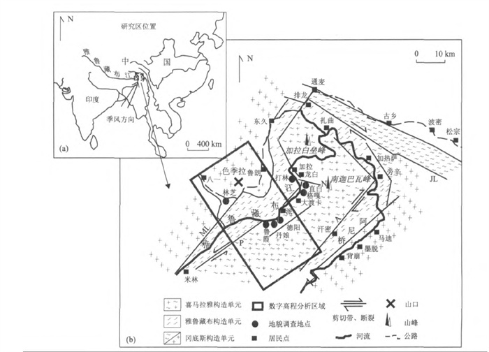
图 1 研究区位置(a)、数字高程剖面工作区域及地质单元(b)
图a中的小箭头表示季风方向; 图b中字母含义: N.南坳大断裂; P.派断裂; ML.东久-米林断裂; A.阿尼桥断裂
Fig. 1. Position of study region (a), DEM selected region and geological sketch map (b)
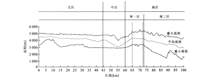
表 1 各地海拔、年平均温度和年降水量情况
Table 1. Elevation, annual mean temperature and annual precipitation in different geomorphic units

-
Burbank, D. W., Anderson, R. S., 2002. Tectonic geomor-phology. Blackwell Science, Massachusetts, 1-274. Cao, K., Wang, G. C., Wang, A., 2007. The analysis of the tectonics and the behavior of the longitudinal section of Kunlun River in East Kunlun. Earth Science—Journalof China University of Geosciences, 32 (5): 713-721 (in Chinese with English abstract). Guan, Z. H., Chen, C. Y., Ou, Y. X., et al., 1984. Rivers andlakes in Tibet. Sciences Press, Beijing (in Chinese). Ji, J. Q., Zhong, D. L., Ding, L., et al., 1999. Genesis and scientific significance of the Yarlung-Zangbo canyon. Earth Science Frontiers, 6 (4): 231-235 (in Chinese with English abstract). Lei, Y. L., 2006. Geochronologic studies on tectono-geomor-phic evolution of the eastern Hi malayan syntaxis sinceLate Miocene ti me: (Dissertation). Institute of Geologyand Geophysics, Chinese Academy of Science, Beijing, China (in Chinese with English abstract). Li, J. J., Zheng, B. X., Yang, X. J., et al., 1986. The glaciers in Tibet. Sciences Press, Beijing, 1-328 (in Chinese). Li, Y., Densmore, A. L., Zhou, Y. J., et al., 2006. Profiles of digital elevation models (DEM) crossing the eastern margin of the Tibetan plateau and their constraints on dissection depths and incision rates of late Cenozoicrivers.Quaternary Sciences 2, 26 (2): 236-243. Liu, D. M., Li, D. W., Xie, D. F., et al., 2003. Primary study on tectonic landforms in northern part of Middle Hima-layan orogen. Earth Science—Journal of China Uni-versity of Geosciences, 28 (6): 639-644 (in Chinesewith English abstract). Liu, J., Ding, L., Zeng, L. S., et al., 2006. Large-scale terrain analysis of selected regions of the Tibetan plateau: Discussion on the origin of plateau planation surface. Earth Science Frontiers, 13 (5): 285-299 (in Chinese withEnglish abstract). Liu, Y. P., Mongomery, D. R., Hallet, B., et al., 2006. Quaternary glacier blocking events at the entrance of Yarlung Zangbo great canyon, Southeast Tibet. Quaternary Sciences, 26 (1): 52-62 (in Chinese with Englishabstract). Lin, Z. Y., Wu, X. D., 1984. Vertical zone of climate and climatic type in the MT, Namjagbarwa region. Mountain Research, 2 (3): 165-173 (in Chinese with English ab-stract). Lin, Z. Y., Wu, X. D., 1985. A preliminary analysis of the climate in the Mt Namjagbarwa region. Mountain Research, 3 (4): 250-257 (in Chinese with English ab-stract). Molnar, P., England, P., 1990. Late Cenozoic uplift of mountain ranges and global climate change: Chicken or egg? Nature, 346 (29-34): 29-34 Mongomery, D. R., Hallet, B., Liu, Y. P., et al., 2004. Evidence for Holocene megafloods down the Tsangpo River gorge, southeastern Tibet. Quaternary Research, 62: 201-207. doi: 10.1016/j.yqres.2004.06.008 Pan, B. T., Gao, H. S., Li, B. Y., et al., 2004. Step-like land-forms and uplift of the Qinghai-Xizang plateau. Quaternary Sciences, 24 (1): 50-57 (in Chinese with Englishabstract). Peng, B. Z., Yang, Y. C., 1996. Geography and resources in Namche Barwa region. Sciences Press, Beijing (in Chi-nese). Tang, G. A., Liu, X. J., Yan, G. N., 2005. Digital elevationmodel and its theory and method at earth science analy-sis. Sciences Press, Beijing (in Chinese). Wang, A., Wang, G. C., Xie, D. F., et al., 2007. Fission track geochronology of Xiaonanchuan pluton and the morphotectonic evolution of eastern Kunlun since Late Miocene. Earth Science—Journal of China University of Geosciences, 32 (1): 51-58 (in Chinese with Englishabstract). Wang, E. Q., Chen, L. Z., Chen, Z. L., 2002. Tectonic and climatic element-controlled evolution of the Yalung-Zangbu River in southern Tibet. Quaternary Sciences, 22 (4): 365-373 (in Chinese with English abstract). Wang, E. Q., Zhou, Y., Chen, Z. L., et al., 2001. Geologic and geomorphic origins of the east Himalayan gap. Chinese Journal of Geology, 36 (1): 122-128 (in Chinesewith English abstract). Wang, Z. C., 1984. A Preliminary research on ancient glacial relics in the Mt. Namjagbarwa region. Mountain Research, 2 (3): 216-220 (in Chinese with English ab-stract). Wu, Z. H., Hu, D. G., Liu, Q. S., et al., 2002a. The formation and evolution of tectonic landform of Damxung area in central Tibetan plateau. Acta Geoscientia Sinica, 23 (5): 423-428 (in Chinese with English abstract). Wu, Z. H., Jiang, W., Wu, Z. H., et al., 2002b. Dating of typical basin and range tectonics in central Tibetan plateau. Acta Geoscientia Sinica, 23 (4): 289-294 (in Chi-nese with English abstract). http://www2.jpl.nasa.gov/srtm/index.html. Yang, Y. C., 1982. The topographic features and the origin of the great bend valley at the Yarlung-Zangbo River in Tibet. Geographic Research, 1 (1): 40-48 (in Chinesewith English abstract). Yang, Y. C., 1984. The geomorphologic characters and the origin in the Mt Namjagbarwa region. Mountain Research, 2 (3): 134-141 (in Chinese with English ab-stract). Yang, Y. C., 1985. The second report on the geomorphology in the Mt Namjagbarwa region. Mountain Research, 3 (4): 227-233 (in Chinese with English abstract). Yang, Y. C., 1999. Newe xploring results of the greatest canyonin the world. Mountain Research, 17 (3): 200-206 (in Chinese with English abstract). Zeng, Q. L., Yang, Z. F., Yuan, G. X., et al., 2007. Songzong Lake: An ice-dammed lake of last glacial maximum in Purlung Tsangpo River, Southeast Tibet. Quaternary Sciences, 27 (1): 85-92 (in Chinese with English ab-stract). Zhang, J. J., Ji, J. Q., Zhong, D. L., et al., 2003. Discussion about the tectonic frame of Namche Barwa region at eastern Himalayan syntaxis and its forming process. Science in China (Series D), 33 (4): 373-383 (in Chi-nese). Zhang, P. Q., Gao, M. X., Liu, X. H., 2008a. Fluvial morphological features of the entrance region of Yalung-Zangbo River great gorge and its response to tectonic movement, south-eastern Tibet. Geographyand Geo-in-formation Science, 24 (3): 45-48 (in Chinese withEnglish abstract). Zhang, P. Q., Liu, X. H., Kong, P., 2008b. Evidences of glacial movement since Last Glacial Period at the ectrance of Yarlung zangbo great canyon and its structural-envi-ronmental implication, north-eastern Tibet. ChineseJournal of Geology, 43 (3): 588-602 (in Chinese withEnglish abstract). Zhang, P. Q., Liu, X. H., 2008. Debris flow distribution and preventions at the great turning in the gorge of Yaluzangbo River, southeastern Tibet. The Chinese Journal of Geological Hazard and Control, 1 (19): 12-17 (in Chinese with English abstract). Zhang, W. J., 1985. Some features of the surge glacier in the Mt Namjagbarwa. Mountain Research, 3 (4): 234-238 (in Chinese with English abstract). Zheng, L. L., Liao, G. Y., Geng, Q. R., et al., 2004. New results and major progress in regional geological survey of the Medog County sheet. Geological Bulletin of China, 23 (5-6): 458-462 (in Chinese with English ab-stract). Zhou, S. Z., Xu, L. B., Patrick, M. C., et al., 2007. Cosmogenic nuclide10Be dating of Guxiang and Baiyu ice age. Chinese Science Bulletins, 52 (8): 945-950 (inChinese). doi: 10.1360/csb2007-52-8-945 曹凯, 王国灿, 王岸, 2007. 东昆仑山昆仑河纵剖面形貌分析及构造涵义. 地球科学——中国地质大学学报, 32 (5): 713-721. https://www.cnki.com.cn/Article/CJFDTOTAL-DQKX200705016.htm 关志华, 陈传友, 区裕雄, 等, 1984. 西藏河流与湖泊. 北京: 科学出版社. 季建清, 钟大赉, 丁林, 等, 1999. 雅鲁藏布大峡谷地质成因. 地学前缘, 6 (4): 231-235. doi: 10.3321/j.issn:1005-2321.1999.04.005 雷永良, 2006. 东喜马拉雅构造结地区晚中新世以来的构造-地貌年代学研究(博士论文). 中国科学院地质与地球物理研究所, 1-79. 李吉均, 郑本兴, 杨锡金, 等, 1986. 西藏冰川. 北京: 科学出版社. 李勇, Densmore, A. L., 周荣军, 等, 2006. 青藏高原东缘数字高程剖面及其对晚新生代河流下切深度和下切速率的约束. 第四纪研究, 26 (2): 236-243. doi: 10.3321/j.issn:1001-7410.2006.02.011 林振耀, 吴祥定, 1984. 南迦巴瓦峰地区垂直气候带及气候类型. 山地研究, 2 (3): 165-173. https://www.cnki.com.cn/Article/CJFDTOTAL-SDYA198403004.htm 林振耀, 吴祥定, 1985. 南迦巴瓦峰地区气候基本特征. 山地研究, 3 (4): 250-257. https://www.cnki.com.cn/Article/CJFDTOTAL-SDYA198504008.htm 刘德民, 李德威, 谢德凡, 等, 2003. 喜马拉雅造山带中段北坡构造地貌初步研究. 地球科学——中国地质大学学报, 28 (6): 639-644. https://www.cnki.com.cn/Article/CJFDTOTAL-DQKX200306009.htm 刘静, 丁林, 曾令森, 等, 2006. 青藏高原典型地区的地貌量化分析——兼对高原"夷平面"的讨论. 地学前缘, 13 (5): 285-299. doi: 10.3321/j.issn:1005-2321.2006.05.002 刘宇平, Mongomery, D. R., Hallet, B., 等, 2006. 西藏东南雅鲁藏布大峡谷入口处第四纪多次冰川阻江事件. 第四纪研究, 26 (1): 52-62. doi: 10.3321/j.issn:1001-7410.2006.01.007 潘保田, 高红山, 李炳元, 等, 2004. 青藏高原层状地貌与高原隆升. 第四纪研究, 24 (1): 50-57. doi: 10.3321/j.issn:1001-7410.2004.01.006 彭补拙, 杨逸畴, 1996. 南迦巴瓦发地区自然地理与自然资源. 北京: 科学出版社 汤国安, 刘学军, 阎国年, 2005. 数字高程模型及地学分析的原理与方法. 北京: 科学出版社. 王岸, 王国灿, 谢德凡, 等, 2007. 东昆仑山小南川岩体裂变径迹年代与中新世晚期以来的构造地貌演化. 地球科学——中国地质大学学报, 32 (1): 51-58. https://www.cnki.com.cn/Article/CJFDTOTAL-DQKX200701006.htm 王二七, 陈良忠, 陈智樑, 2002. 在构造和气候因素制约下的雅鲁藏布江的演化. 第四纪研究, 22 (4): 365-373. doi: 10.3321/j.issn:1001-7410.2002.04.009 王二七, 周勇, 陈智樑, 等, 2001. 东喜马拉雅缺口的地质与地貌成因. 地质科学, 36 (1): 122-128. doi: 10.3321/j.issn:0563-5020.2001.01.015 王志超, 1984. 南迦巴瓦峰地区古冰川遗迹概述. 山地研究, 2 (3): 216-220. https://www.cnki.com.cn/Article/CJFDTOTAL-SDYA198403011.htm 吴珍汉, 胡道功, 刘崎胜, 等, 2002a. 西藏当雄地区构造地貌及形成演化过程. 地球学报, 23 (5): 423-428. https://www.cnki.com.cn/Article/CJFDTOTAL-DQXB200205006.htm 吴珍汉, 江万, 吴中海, 等, 2002b. 青藏高原腹地典型盆-山构造形成时代. 地球学报, 23 (4): 289-294. https://www.cnki.com.cn/Article/CJFDTOTAL-DQXB200204000.htm 杨逸畴, 1982. 雅鲁藏布江大拐弯峡谷的地貌特征和成因. 地理研究, 1 (1): 40-48. https://www.cnki.com.cn/Article/CJFDTOTAL-DLYJ198201006.htm 杨逸畴, 1984. 南迦巴瓦峰地区地貌的基本特征和成因. 山地研究, 2 (3): 134-141. https://www.cnki.com.cn/Article/CJFDTOTAL-SDYA198403001.htm 杨逸畴, 1985. 再论南迦巴瓦峰地区的地貌. 山地研究, 3 (4): 227-233. https://www.cnki.com.cn/Article/CJFDTOTAL-SDYA198504005.htm 杨逸畴, 1999. 徒步穿越考察世界第一大峡谷最新成果. 山地学报, 17 (3): 200-206. doi: 10.3969/j.issn.1008-2786.1999.03.002 曾庆利, 杨志法, 袁广祥, 等, 2007. 松宗古湖——藏东南帕隆藏布江末次盛冰期发育的一个冰川堰塞湖. 第四纪研究, 27 (1): 85-92. doi: 10.3321/j.issn:1001-7410.2007.01.010 张进江, 季建清, 钟大赉, 等, 2003. 东喜玛拉雅南迦巴瓦构造结的构造格局及形成过程探讨. 中国科学(D辑), 33 (4): 373-383. 张沛全, 高明星, 刘小汉, 2008a. 西藏雅鲁藏布江大拐弯入口流水地貌特征及其对构造运动的响应. 地理与地理信息科学, 24 (3): 45-48. https://www.cnki.com.cn/Article/CJFDTOTAL-DLGT200803011.htm 张沛全, 刘小汉, 孔屏, 2008b. 雅鲁藏布江大拐弯地区末次冰期以来的冰川活动证据及其构造-环境意义. 地质科学, 43 (3): 588-602. https://www.cnki.com.cn/Article/CJFDTOTAL-DZKX200803014.htm 张沛全, 刘小汉, 2008. 雅鲁藏布江大拐弯入口段泥石流特征及应对措施. 中国地质灾害与防治学报, 1 (19): 12-17. https://www.cnki.com.cn/Article/CJFDTOTAL-ZGDH200801004.htm 张文敬, 1985. 南迦巴瓦峰跃动冰川的某些特征. 山地研究, 3 (4): 234-238. https://www.cnki.com.cn/Article/CJFDTOTAL-SDYA198504006.htm 郑来林, 廖光宇, 耿全如, 等, 2004. 墨脱县幅地质调查新成果及主要进展. 地质通报, 23 (5-6): 458-462. https://www.cnki.com.cn/Article/CJFDTOTAL-ZQYD2004Z1009.htm 周尚哲, 许刘兵, Patrick, M. C., 等, 2007. 古乡冰期和白玉冰期的宇宙成因核素10Be定年. 科学通报, 52 (8): 945-950. doi: 10.3321/j.issn:0023-074X.2007.08.016 -

 下载:
下载:
 点击查看大图
图(3) / 表(1)
计量
- 文章访问数: 4611
- HTML全文浏览量: 667
- PDF下载量: 183
- 被引次数: 0
