


The Analysis of the Tectonics and the Behavior of the Longitudinal Section of Kunlun River in East Kunlun
-
摘要: 青藏高原东昆仑北部地区新构造活动强烈, 存在一系列活动断层, 控制了该地区的地貌格局和水系的发育.其中大部分活动断层是已经确定下来的, 还有一些活动断层还处在定性推测阶段.引进河流长度-坡度参数(以下简称“SL参数”) 和Hack剖面2个能够有效反映区域新构造活动的地质参数, 对昆仑河纵剖面坡度变化进行详细刻画和研究, 并对昆仑河河流阶地进行空间对比分析.研究结果表明, 昆仑河河流的Hack剖面与SL参数存在形貌上的对应关系, SL参数的突变主要是受断裂构造活动控制; 证实了昆仑河-野牛沟断裂和东昆中断裂第四纪以来存在构造活动性; 第四纪以来强烈的构造差异隆升作用控制了东昆仑地区的地貌水系发育格局, 并将产生更深远的影响.Abstract: There are strong, fresh tectonic processes and a series of active faults in the northern part of East Kunlun in Tibetan plateau, controlling the geomorphology and the water system of this area. Most of the active faults have been confirmed, while some are only presumed qualitatively at present. This paper introduces two kinds of geological factors, the Stream Length-gradient index (SL index) and Hack profile, which can effectively reflect regional tectonics, and particularly describes and studies the gradient change of the longitudinal profile of the Kunlun river and the contrast of river terraces in space in Kunlun area. It shows that there exists a corresponding relationship between Hack profile and SL index of the Kunlun river in shape and the mutation of the SL index is mainly controlled by the action of fault. We have also proved the activity of the Kunlunhe-Yeniugou fault and the central fault of east Kunlun from Quaternary, and believe that strong differentia uplift controls the geomorphologic evolution and river development of east Kunlun and will exert far-reaching influence on them.
-
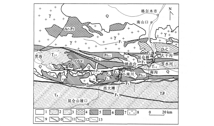
图 1 研究区地质简图
1.第四纪地层; 2.三叠纪中下统洪水川组、闹仓坚沟组和希里可特组; 3.三叠纪巴颜喀拉山岩群; 4.泥盆纪和石炭纪碎屑岩群、火山岩群; 5.奥陶纪纳赤台岩群; 6.中元古界万保沟岩群; 7.太古代、早元古界变质岩; 8.加里东晚期-燕山早期侵入岩; 9.第四纪以前的断裂; 10.活动断裂; 11.韧性剪切带; 12.公路及地点; 13.河流(注: 昆仑桥至大干沟段出露少量第三纪基岩)
Fig. 1. The relief framework of geology in research area
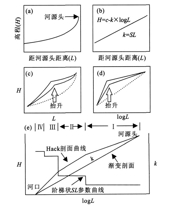
图 2 理想的Hack剖面
a.渐变河流的纵剖面; b.渐变河流的半对数图, 即所谓的Hack剖面图, 是一条斜率为k (SL参数) 的直线; c.经过抬升后的河流纵剖面图, 在下游突然变陡处有一个明显的裂点; d.河流抬升后的Hack剖面图; e.Hack剖面曲线可以划分为4个渐变的河段(Ⅰ、Ⅱ、Ⅲ和Ⅳ), 每个部分都是线性相关的, 它们的SL参数就构成了阶梯状的SL参数曲线(据Chen et al.修改, 2003)
Fig. 2. Conceptual diagram of Hack profiles
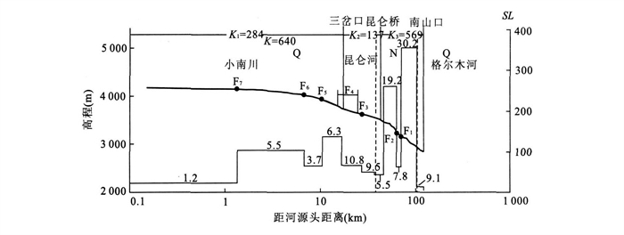
图 3 昆仑河SL参数阶梯状曲线和Hack剖面
粗体实线表示河流的Hack剖面曲线, 垂直虚线表示河流流经的主要的岩性分界, 图中的K值表示河流的侵蚀能力.阶梯上的数字表示每一河段的长度值(km).需要说明的是, 这里所指的河源头实际上为起测点
Fig. 3. The step curve of SL index of Kunlun River and Hack profiles
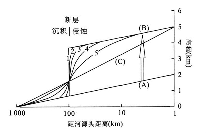
图 4 断层引起的渐变河流的变化和调整(据Brookfield, 1998, 修改)
a.渐变河流剖面; b.由于突然的断层位错移至; c.侵蚀-沉积拐点保持常数.实际上, 它会从下游迁移到上游, 在断层附近侵蚀要早于沉积, 连续的剖面1-5反映了河流朝着可能发生的新的平衡剖面演变的趋势
Fig. 4. Change in graded river profile by fault movement and the resulting adjustments
-
Brookfield, M. E., 1998. The evolution of the great river systems of southern Asia during the Cenozoic India-Asia collision: Rivers draining southwards. Geomorphology, 2: 285-312. Chen, Y. C., Sung, Q. C., Cheng, K. Y., 2003. Along-strike variations of morphotectonic features in the western Foothills of Tai wan: Tectonic implications based on stream-gradient and hypsometric analysis. Geomorphology, 56: 109-137. doi: 10.1016/S0169-555X(03)00059-X Cheng, S. P., Deng, Q. D., Li, C. Y., et al., 2004. Dynamical mechanism, physical erosion processes and influence factors of fluvial incision: A review and prospect. Quaternary Science, 24 (4): 421-429 (in Chinese with English abstract). Cui, Z. J., Gao, Q. Z., Liu, G. N., et al., 1996. Planation surfaces, palaeokarst and uplift of Xizang (Tibet) plateau. Science in China (Ser. D), 39 (4): 391-400. Cui, Z. J., Wu, Y. Q., Liu, G. N., 1997. Discovery and character of the Kunlun-Yellow river movement. Chinese Science Bulletin, 42 (18): 1986-1989 (in Chinese). doi: 10.1360/csb1997-42-18-1986 Cui, Z. J., Wu, Y. Q., Liu, G. N., et al., 1998. On Kunlun-Yellow river tectonic movement. Sciencein China (Ser. D), 41 (6): 53-59. Cui, Z. J., Wu, Y. Q., Liu, G. N., et al., 2001. Quaternary geomorphologic evolution of the Kunlun pass area and uplift of the Qinghai-Xizang (Tibet) plateau. Geomorphology, 36: 203-216. doi: 10.1016/S0169-555X(00)00057-X Gao, Y. L., Wu, X. N., Zuo, G. C., 1988. The characters and tectonic significance of ophiolite fist discovered in the East Kunlun area. Northwest Geoscience, 21: 664-669 (in Chinese with English abstract). Hack, J. T., 1973. Stream-profile analysis and stream-gradient index. U. S. Geol. Surv. J. Res., 1: 421-429. Li, C. A., Yin, H. F., Yu, Q. W., et al., 1998. Evolution of drainage system and its development trend in connection with tectonic uplift of eastern Kunlun Mt. Earth Science—Journal of China University of Geosciences, 23 (5): 456-460 (in Chinese with English abstract). Liang, C. H., 2002. Geology and Geomorphology. China Agricultural Press, Beijing, 176-205 (in Chinese). Merritts, D. J., Vincent, K. R., 1989. Geomorphic response of coastal streams to low, intermediate, and high rates of uplift, Mendocino Triple Junction region, northern California. Geol. Soc. Amer. Bull., 110: 1373-1388. Merritts, D. J., Vincent, K. R., Wohl, E. E., 1994. Long river profiles tectonism and eustasy: A guide to interpreting fluvial Terraces. J. Geophys. Res., 99 (B7): 14031-14050. doi: 10.1029/94JB00857 Wang, A., Wang, G. C., Xiang, S. Y., 2003. Charactcristics of river terraces in north slope of eastern Kunlun mountains and their relationship with plateau uplift. Earth Science—Journal of China University of Geosciences, 28 (6): 675-679 (in Chinese with English abstract). Wang, G. C., Hou, G. J., Zhang, K. X., et al., 2002. Mountain building and its dynamic transition since middle Pleistocene in east of eastern Kunlun, northeast Tibet Plateau. Earth Science—Journal of China University of Geosciences, 27 (1): 4-12 (in Chinese with English abstract). Wang, G. C., Wu, Y. L., Xiang, S. Y., et al., 2003. Mountainbuilding process and geomorphic migration of easternKunlun mountains during Quaternary. Earth Science—Journal of China University of Geosciences, 28 (6): 583-592 (in Chinese with English abstract). Wei, Q. W., Tan, L. H., Wang, S. J., 2006. Formation and evolution of river terrace and environment responses. Progress in Geography, 25 (3): 55-61 (in Chinese with English abstract). Wei, W. B., Jin, S., Ye, G. F., et al., 2006. Features of the faults in Center and North Tibetan plateau: Based on results of INDEPTH (Ⅲ) -MT. Earth Science—Journalof China University of Geosciences, 31 (2): 257-265 (in Chinese with English abstract). Wu, Y. Q., Cui, Z. J., Ge, D. K., et al., 1999. When the Qinghai-Xizang (Tibet) Plateau uplift to present altitude-take the Kunlun pass area for example. Geomorphology, 19 (6): 481-484 (in Chinese with English abstract). Xiang, S. Y., Wang, G. C., Deng, Z. L., 2003. The sedimental response to important tectonic events of Cenozoic plateau uplift, cast segment of eastern Kunlun mountains. Earth Science—Journal of China University of Geosciences, 28 (6): 616-620 (in Chinese with English abstract). Zhang, W. Q., Wang, C. F., Liu, C. D., et al., 2002. A discussion on geological background of the east Kunlun area by geochemical exploration data. Geoscience, 16 (30): 257-262 (in Chinese with English abstract). Zhang, Z. Y., Yu, Q. W., Zhang, K. X., et al., 2003. Geomorphological evolution of Quaternary river from upper Yellow River and geomorphologic evolution investigation for 1∶250000 scale geological mappingin Qinghai-Tibet Plateau. Earth Science—Journal of China University of Geosciences, 28 (6): 621-626 (in Chinese with English abstract). 程绍平, 邓起东, 李传友, 等, 2004. 流水下切的动力学机制、物理侵蚀过程和影响因素评述和展望. 第四纪研究, 24 (4): 421-429. doi: 10.3321/j.issn:1001-7410.2004.04.008 崔之久, 高全洲, 刘耕年, 等, 1996. 夷平面、古岩溶与青藏高原隆升. 中国科学(D辑), 26 (4): 378-386. https://www.cnki.com.cn/Article/CJFDTOTAL-JDXK199604014.htm 崔之久, 伍永秋, 刘耕年, 1997. "昆仑-黄河运动"的发现及其性质. 科学通报, 42 (18): 1986-1989. doi: 10.3321/j.issn:0023-074X.1997.18.019 崔之久, 伍永秋, 刘耕年, 等, 1998. 关于"昆仑-黄河运动中国科学(D辑), 28 (10): 53-59. 高延林, 吴向农, 左国朝, 1988. 东昆仑山清水泉蛇绿岩特征及其大地构造意义. 西北地质科学, 21: 664-669. https://www.cnki.com.cn/Article/CJFDTOTAL-XBFK198801001.htm 李长安, 殷鸿福, 于庆文, 等, 1998. 昆仑山东段的构造隆升、水系响应与环境变化. 地球科学———中国地质大学学报, 23 (5): 456-460. https://www.cnki.com.cn/Article/CJFDTOTAL-DQKX805.003.htm 梁成华, 2002. 地质与地貌学. 北京: 中国农业出版社, 176-205. https://www.cnki.com.cn/Article/CJFDTOTAL-KJFT202018031.htm 王岸, 王国灿, 向树元, 2003. 东昆仑山东段北坡河流阶地发育及其与构造隆升的关系. 地球科学———中国地质大学学报, 28 (6): 675-679. https://www.cnki.com.cn/Article/CJFDTOTAL-DQKX200306014.htm 王国灿, 侯光久, 张克信, 等, 2002. 东昆仑东段中更新世以来的成山运动及其动力转换. 地球科学———中国地质大学学报, 27 (1): 4-12. https://www.cnki.com.cn/Article/CJFDTOTAL-DQKX200201001.htm 王国灿, 吴燕玲, 向树元, 等, 2003. 东昆仑东段第四纪成山作用过程与地貌变迁. 地球科学———中国地质大学学报, 28 (6): 583-592. https://www.cnki.com.cn/Article/CJFDTOTAL-DQKX200306001.htm 魏全伟, 谭利华, 王随继, 2006. 河流阶地的形成、演变及环境效应. 地理科学进展, 25 (3): 55-61. doi: 10.3969/j.issn.1007-6301.2006.03.007 魏文博, 金胜, 叶高峰, 等, 2006. 西藏高原中、北部断裂构造特征: INDEPTH (Ⅲ) -MT观测提供的依据. 地球科学———中国地质大学学报, 31 (2): 257-265. https://www.cnki.com.cn/Article/CJFDTOTAL-DQKX200602016.htm 伍永秋, 崔之久, 葛道凯, 等, 1999. 青藏高原何时隆升到现代的高度—以昆仑山垭口地区为例. 地理科学, 19 (6): 481-484. doi: 10.3969/j.issn.1000-0690.1999.06.001 向树元, 王国灿, 邓中林, 2003. 东昆仑东段新生代高原隆升重大事件的沉积响应. 地球科学———中国地质大学学报, 28 (6): 616-620. https://www.cnki.com.cn/Article/CJFDTOTAL-DQKX200306005.htm [d+] 张文秦, 汪彩芳, 刘成东, 等, 2002. 依据化探成果对东昆仑地质背景的讨论. 现代地质, 16 (3): 257-262. doi: 10.3969/j.issn.1000-8527.2002.03.007 张智勇, 于庆文, 张克信, 等, 2003. 黄河上游第四纪河流地貌演化兼论青藏高原1∶25万新生代地质填图地貌演化调查. 地球科学———中国地质大学学报, 28 (6): 621-626. https://www.cnki.com.cn/Article/CJFDTOTAL-DQKX200306006.htm -

 下载:
下载:
 点击查看大图
计量
- 文章访问数: 3642
- HTML全文浏览量: 674
- PDF下载量: 205
- 被引次数: 0
