


Quantitative Extraction of Deformation Parameters of Active Tectonics Based on CORONA Stereo Pairs
-
摘要: 为了高效提取活动构造研究的定量参数, 利用美国解密的2 m分辨率CORONA KH-4B卫星立体像对, 实现了在JX4C数字摄影测量系统的立体测图, 并通过影像匹配的方法建立数字高程模型(DEM)和数字正射影像(DOM).通过以上方法, 以南天山库车冲断褶皱带为例, 利用覆盖该区的影像, 识别由活动断层和活动褶皱造成的第四纪沉积物的变形, 提取地表变形参数, 结合地震资料和野外测量, 分析地表变形特征的深部构造机理.结果表明, 经过处理的CORONA KH-4B像对可以在数字摄影测量系统下矢量测图, 相对定向精度在0.01 mm左右, 绝对定向精度在10 m左右.测量精度能够满足活动构造定量分析所需.该方法在地势复杂、人迹罕至区域研究中更具优势.Abstract: In order to efficiently extract quantitative parameters in active tectonics research, JX4C digital photogrammetric system has been used to found stereo model based on CORONA KH-4B stereo pairs with 2 m resolution, which were declassified in 1995 by USA for scientific purpose. Meanwhile, large scale digital elevation model (DEM) and digital orthophoto mapping (DOM) have been formed. These processing techniques are applied in a case study of the Kuqa fold-and-thrust belt in southern Tianshan, China, to quantitatively analyze the Kumugeliemu active fault and the Qiulitage active fault-related folds, considering the seismic reflection profiles therein and data from field measurements. Results show that the CORONA stereo pairs can be used in JX4C digital photogrammetric system, and root mean square error (RMS) of relative orientation is about 0.01 mm, while absolute orientation is about 10 m. Some parameters for deformation of river terrace and fault and fold scarps are identified and measured, which are helpful to reveal the characters of active tectonics. The processing techniques are feasible and effective particularly in remote settings with complex topology and the measurement precision can meet the requirement for analysis of active tectonics.
-
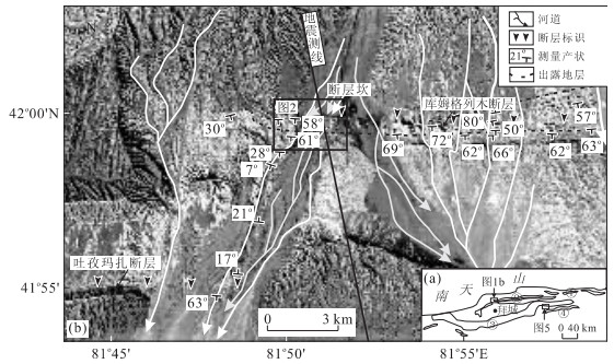
图 1 (a) 南天山库车坳陷构造简图,标识该区发育的4排冲断褶皱带;(b)CORONA影像显示库姆格列木背斜西段河流冲-洪积扇和断层陡坎
Fig. 1. (a) Tectonics sketch of Kuqa area showing 4 fold-thrust belts; (b) CORONA imagary showing the alluvial fan and fault scarp in west of Kumugeliemu anticline
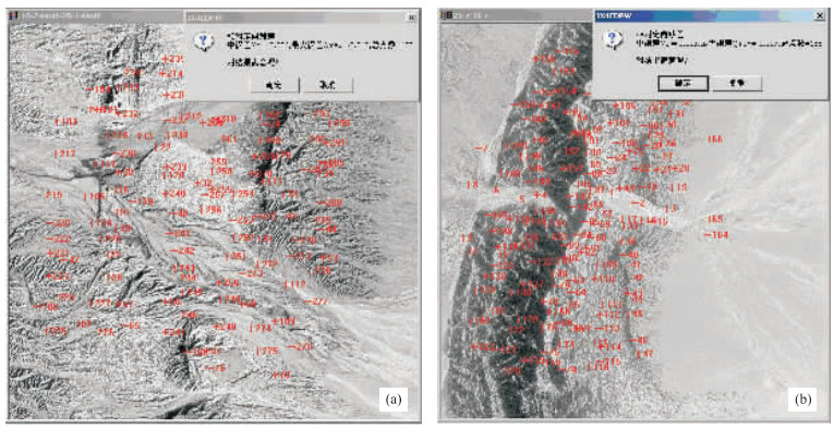
图 2 相对定向匹配点的分布及精度
a.18~24像对显示库姆格列木活动断层;b.25~31像对显示库车塔吾背斜南翼褶皱崖
Fig. 2. Accuracy and distribution of match points in relative orientation
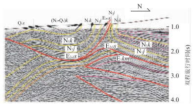
图 4 库姆格列木断裂带西段地震剖面
蝌蚪线表示地表地层倾角,虚线表示背斜北翼生长地层,箭头指示断层逆冲方向
Fig. 4. Seismic reflection profile across the western segment of the Kumugeliemu fault belt
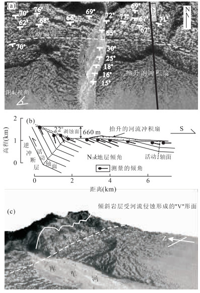
图 5 (a) CORONA影像显示库车塔吾背斜南翼库车河处岩层出露特征;(b)从DEM提取的地形剖面,显示地表褶皱和深部构造的关系;(c)DOM与DEM叠加生成的3维可视化,显示抬升的河流冲积扇及出露的岩层三角面
Fig. 5. (a) CORONA imagery showing the character of beds in the south of Kuchetaw anticline; (b) topographic profile extracted in DEM showing the relation between surface fold and subsurface structure; (c) DOM draped over DEM showing uplifted alluvial fan and triangular facets
表 1 相对定向和绝对定向精度
Table 1. Accuracy (RMS) of relative orientation and absolute orientation
像对DS1105-1007 位置 相对定向 绝对定向 匹配点数 中误差(mm) 最大误差(mm) 控制点数 中误差(m) M x M y M xy M z DF019-DA025 地势低缓区 122 0.006 0.013 3 0.606 1.004 1.173 0.030 DF025-A031 地势高陡区 155 0.003 0.007 4 10.162 8.245 13.086 3.444 注:Mx、My、Mz、Mxy表示JX4C数字摄影测量系统根据样本在绝对定向中计算的不同方向的中误差值.  下载: 导出CSV
-
Altmaier, A., Kany, C., 2002. Digital surface model generation from CORONA satellite images. ISPRS Journal of Photogrammetry & Remote Sensing, 56(4): 221-235. doi: 10.1016/S0924-2716(02)00046-1 Bai, M.X., 1998. Data of valley terraces in Xinjiang. Inland Earthquake, 12(1): 13-19 (in Chinese with English abstract). Chen, J., Scharer, K.M., Burbank, D.W., et al., 2005. Kinematic models of fluvial terraces over active fault-related folds: constraints on the growth mechanism and kinematics. Seismology and Geology, 17(4): 513-529 (in Chinese with English abstract). http://www.en.cnki.com.cn/Article_en/CJFDTOTAL-DZDZ200504000.htm Chen, L.C., Chen, G.H., Chen, L.Z., et al., 2006. ETM image characteristics and interpretation of active tectonics of the area around the Kalpingtag thrust system. Seismology and Geology, 28(2): 289-298 (in Chinese with English abstract). http://en.cnki.com.cn/Article_en/CJFDTotal-DZDZ200602011.htm Chen, N.H., Wang, X., Yang, S.F., 2007. Quantitative extraction of shallow stratum information based on CORONA imagery. Journal of Zhejiang University (Engineering Science), 41(4): 662-667 (in Chinese with English abstract). http://en.cnki.com.cn/Article_en/CJFDTOTAL-ZDZC200704026.htm Deng, Q.D., Chen, L.C., Ran, Y.K., 2004. Quantitative studies and applications of active tectonics. Earth Science Frontiers, 11(4): 383-392 (in Chinese with English abstract). http://en.cnki.com.cn/Article_en/CJFDTOTAL-DXQY200404006.htm Deng, Q.D., Feng, X.Y., Zhang, P.Z., et al., 2000. Active tectonics in Tianshan. Seismological Press, Beijing (in Chinese). Deng, Q.D., Zhang, P.Z., Ran, Y.K., et al., 2003. Basic characteristics of active tectonics of China. Science in China (Series D), 46(4): 356-372. doi: 10.1360/03yd9032 Fan, X.T., Lu, H.F., Guo, H.D., et al., 2000. Neotectonic analysis of the Kuqa foreland thrust belt by using remote sensing data. Geological Review, 46(5): 499-506 (in Chinese with English abstract). http://en.cnki.com.cn/Article_en/CJFDTOTAL-DZLP200005009.htm Hooper, D.M., Bursik, M.I., Webb, F.H., 2003. Application of high-resolution, interferometric DEMs to geomorphic studies of fault scarps, Fish Lake Valley, Nevada-California, USA. Remote Sensing of Environment, 84: 255-267. doi: 10.1016/S0034-4257(02)00110-4 Hubert-Ferrafi, A., Suppe, J., Gonzalez-Mieres, R., et al., 2007. Mechanisms of active folding of the landscape (southern Tian Shan, China). Journal of Geophysical Research, 112(B3), B03S09-1-B03S09-39. doi: 10.1029/2006JB004362 Jordan, G., Meijninger, B.M.L., Hinsbergen, D.J.J., et al., 2005. Extraction of morphotectonic features from DEMs: development and applications for study areas in Hungary and NW Greece. International Journal of Applied Earth Observation and Geoinformation, 7(3): 163-182. doi: 10.1016/j.jag.2005.03.003 Lu, H.F., Jia, D., Chen, C.M., et al., 1999. Nature and timing of the Kuqa Cenozoic structures. Earth Science Frontiers, 6(4): 215-221 (in Chinese with English abstract). Lu, H.F., Wang, S.L., Suppe, J., et al., 2002. Quaternary folding in the south piedmont of central segment of Tianshan mountains. Chinese Science Bulletin, 47(21): 1675-1679 (in Chinese). doi: 10.1360/csb2002-47-21-1675 Schwartz, D.P., 1988. Geologic characterization of seismic sources: moving into the 1990s. Geotechnical Special Publication, 20: 1-42. Sohn, H.G., Kim, G.H., Yom, J.H., 2004. Mathematical modelling of historical reconnaissance CORONA KH-4B IMAGERY. The Photogrammetric Record, 19(105): 51-66. doi: 10.1046/j.0031-868X.2003.00257.x Suppe, J., 1983. Geometry and kinematics of fault-bend folding. American Journal of Science, 283(7): 684-721. doi: 10.2475/ajs.283.7.684 Suppe, J., Sabat, F., Munoz, J.A., et al., 1997. Bed-by-bed fold growth by kind-bend migration: sant Lorence de Morunys, eastern Paeness. Journal of Structural Geology, 19(3-4): 443-461. doi: 10.1016/S0191-8141(96)00103-4 Tao, C.V., Hu, Y., 2001. A comprehensive study of the rational function model for photogrammetric processing. Photogrammetric Engineering & Remote Sensing, 67(12): 1347-1357. Walker, R.T., 2006. A remote sensing study of active folding and faulting in southern Kerman Province, S.E. Iran. Journal of Structural Geology, 28(4): 654-668. doi: 10.1016/j.jsg.2005.12.014 Wallace, R.E., 1987. Grouping and migration of surface faulting and variations in slip rates on faults in the great basin province. Bull. Seism. Soc. Am. , 77(3): 868-876. http://www.researchgate.net/publication/279660755_Grouping_and_migration_of_surface_faulting_and_variations_in_slip_rates_on_faults_in_the_Great_Basin_Province Wang, X., Ferrafi, A.H., Suppe, J., 2001. Shortening rate since Late Pleistocene in Aksu area, southern flank of Tianshan, China. Chinese Journal of Geology, 36(2): 195-202 (in Chinese with English abstract). http://en.cnki.com.cn/Article_en/ http://search.cnki.net/down/default.aspx?filename=DZKX200102007&dbcode=CJFD&year=2001&dflag=pdfdown Wang, X., Jia, C.Z., Yang, S.F., et al., 2002. The time of deformation on the Kuqa fold-and-thrust belt in the southern Tianshan—based on the Kuqa River area. Acta Geologica Sinica, 76(1): 55-63 (in Chinese with English abstract). http://epub.cnki.net/grid2008/docdown/docdownload.aspx?filename=DZXE200201010&dbcode=CJFD&year=2002&dflag=pdfdown Wu, C.Y., Shen, J., Chen, J.B., et al., 2006. Preliminary study of late Quaternary crustal shortening rate along Kuqa depression in South Tianshan, Xinjiang. Seismology and Geology, 28(2): 279-288 (in Chinese with English abstract). Zheng, W.J., Guo, H., Yuan, D.Y., et al., 2002. Application of remote sensing image information in the research of active faults. Earthquake Research in Plateau, 14(2): 15-21 (in Chinese with English abstract). http://www.cnki.com.cn/Article/CJFDTotal-GYDZ200202002.htm 柏美祥, 1998. 新疆河谷阶地的年代. 内陆地震, 12(1): 13-19. https://www.cnki.com.cn/Article/CJFDTOTAL-LLDZ199801001.htm 陈杰, Scharer, K.M., Burbank, D.W., 等, 2005. 利用河流阶地限定活动褶皱的类型和生长机制: 运动学模型. 地震地质, 17(4): 513-529. doi: 10.3969/j.issn.0253-4967.2005.04.001 陈立春, 陈桂华, 陈立泽, 等, 2006. 柯坪塔格推覆系活动构造的ETM影像特征与解译. 地震地质, 28(2): 289-298. doi: 10.3969/j.issn.0253-4967.2006.02.012 陈宁华, 汪新, 杨树锋, 2007. 基于CORONA影像的浅层地层信息定量提取. 浙江大学学报(工学版), 41(4): 662-667. doi: 10.3785/j.issn.1008-973X.2007.04.027 邓起东, 陈立春, 冉勇康, 2004. 活动构造定量研究与应用. 地学前缘, 11(4): 383-392. doi: 10.3321/j.issn:1005-2321.2004.04.005 邓起东, 冯先岳, 张培震, 等, 2000. 天山活动构造, 北京: 地震出版社. 邓起东, 张培震, 冉勇康, 等, 2002. 中国活动构造基本特征. 中国科学(D辑), 32(12): 1020-1030. https://www.cnki.com.cn/Article/CJFDTOTAL-JDXK200212006.htm 范湘涛, 卢华复, 郭华东, 等, 2000. 库车冲断带新构造遥感分析. 地质论评, 46(5): 499-506. doi: 10.3321/j.issn:0371-5736.2000.05.008 卢华复, 贾东, 陈楚铭, 等, 1999. 库车新生代构造性质和变形时间. 地学前缘, 6(4): 215-221. doi: 10.3321/j.issn:1005-2321.1999.04.003 卢华复, 王胜利, Suppe, J., 等, 2002. 天山中段南麓的第四纪褶皱作用. 科学通报, 47(21): 1675-1679. doi: 10.3321/j.issn:0023-074X.2002.21.015 汪新, Ferrafi, A.H., Suppe, J., 2001. 晚更新世以来南天山阿克苏地区地壳缩短率. 地质科学, 36(2): 195-202. doi: 10.3321/j.issn:0563-5020.2001.02.007 汪新, 贾承造, 杨树锋, 等, 2002. 南天山库车冲断褶皱带构造变形时间——以库车河地区为例. 地质学报, 76(1): 55-63. https://www.cnki.com.cn/Article/CJFDTOTAL-DZXE200201010.htm 吴传勇, 沈军, 陈建波, 等, 2006. 新疆南天山库车坳陷晚第四纪以来地壳缩短速率的初步研究. 地震地质, 28(2): 279-288. doi: 10.3969/j.issn.0253-4967.2006.02.011 郑文俊, 郭华, 袁道阳, 等, 2002. 遥感影像信息在活动断裂研究中的应用. 高原地震, 14(2): 15-21. doi: 10.3969/j.issn.1005-586X.2002.02.003 -

 点击查看大图
计量
- 文章访问数: 3751
- HTML全文浏览量: 593
- PDF下载量: 91
- 被引次数: 0
