


Element-Oriented Land-Use Classification of Mining Area by High Spatial Resolution Remote Sensing Image
-
摘要: 为了合理开发矿产资源和有效监测矿区生态环境,采用面向基元的分类方法,对广西横县某矿区的高分辨率航空遥感影像进行了土地利用分类.通过优化分形网络演化多尺度分割方法,高效提取了矿区两个尺度上的影像基元层;基于基元信息,详细分析了各地表地物光谱特征、空间特征以及类相关特征,建立了研究区土地利用的分类知识库;采用决策支持的模糊逻辑推理法进行分类,使分类的精度从53%提高到了90%.表明面向基元的方法能较好地利于高空间分辨率矿区影像的各种特征进行高精度的土地利用分类.Abstract: For the purpose of rational exploitation of mineral resources and effective monitor of ecological environment in mining areas, we did experiments about land-use classification of the high spatial resolution airborne image from a mining area in Heng County of Guangxi province using element-oriented method. By optimizing the evolution of multi-scale fractal network segment process, two levels of image elements were extracted efficiently. Based on the multi-scale image elements, the land-use classification knowledge base of the study area was established through analyzing spectral, spatial and class-relation features in this area. The classification precision improved from 53% to 90% by decision supporting fuzzy logic reasoning of the knowledge base. The experiments show that the element-oriented method can obtain high precision land-use classification for taking full advantage of various features of the mining area from the high spatial resolution image.
-
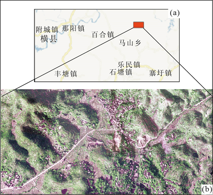
图 1 研究区位置(a)和研究区高空间分辨率航空影像(b)
Fig. 1. Location of the study area (a) and high spatial resolution aerial image of the study area (b)
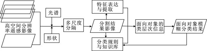
图 2 面向基元的遥感影像分类流程
Fig. 2. The flow chart of remote sensing image classification by element oriented method

图 3 (a) 面向基元方法的分类结果和(b)LVQ神经网络监督分类结果
Fig. 3. (a) The classification result by element-oriented method and (b) The supervised classification result by LVQ neural network method
表 1 研究区分类知识库规则
Table 1. The classification rule of knowledge base from the study area
地类 推理规则 水体 32<L1<84 and 28<L2<62(3次高斯模糊函数) and L2/L1>1.2 农田 107<L1<132 and 120<L2<151 and 83<L3<110(3次高斯模糊函数) 道路 L3>152 and长宽比>2 居民地 GLDV对比度L2>980 矿区 L2>220 and紧邻矿区的居民地 林地 非水体and非农田and非道路and非居民地and非矿区  下载: 导出CSV
表 2 面向基元分类误差矩阵及精度评价
Table 2. Error matrix and accuracy assessment on basic element-oriented
结果\参考 水体 道路 林地 矿区 农田 居民地 像元数 用户精度 水体 381 0 0 0 0 59 440 0.865 9 道路 0 406 0 0 0 24 420 0.966 7 林地 28 0 6 139 68 102 83 6 420 0.956 2 矿区 0 0 17 248 0 9 274 0.905 1 农田 0 8 90 0 1 417 0 1 515 0.935 3 居民地 0 7 39 14 37 1 254 1 351 0.928 2 像元数 409 421 6 285 330 1 556 1 429 10 430 生产精度 0.931 5 0.964 4 0.976 8 0.751 5 0.910 7 0.877 5 总精度 0.943 9 Kappa系数 0.904 2
下载: 导出CSV
表 3 监督分类(LVQ)误差矩阵及精度评价
Table 3. Error matrix and accuracy assessment on supervised classification
结果\参考 水体 道路 林地 矿区 农田 居民地 像元数 水体 0 0 0 0 0 0 0 道路 0 541 0 449 0 1 080 2 070 林地 565 0 4 680 1 37 3 402 8 685 矿区 0 280 245 719 0 461 1 705 农田 0 20 759 333 4 537 1 782 7 431 居民地 0 0 0 0 0 0 0 像元数 565 841 5 684 1 502 4 574 6 725 19 891 生产精度 0.000 0.643 0.823 0.479 0.992 0.000 总精度 0.53 Kappa系数 0.45
下载: 导出CSV
-
Baatz, M., Schape, A., 2000. Multiresolution segmentation: an optimization approach for high quality multi-scale image segmentation. http://www.ecognition.cc/download/baatz_schaepe.pdf Benz, U.C., Hofmann, P., Willhauck, G., et al., 2004. Multi-resolution, object-oriented fuzzy analysis of remote sensing data for GIS-ready information. ISPRS Journal of Photogrammetry & Remote Sensing, 58(3-4): 239-258. doi: 10.1016/j.isprsjprs.2003.10.002 Blaschke, T., Strobl, J., 2001. What's wrong with pixels? some recent developments interfacing remote sensing and GIS. GeoBIT/GIS, 14(6): 12-17. doi: 10.1016/j.isprsjprs.2009.06.004 Chen, Q.H., Liu, X.G., Gao, W., et al., 2009. A fast and efficient high spatial resolution multi-scale image segmentation strategy. The 2nd international conference on earth observation for global changes (EOGC2009), Chengdu, 25-29. Du, F.L., Tian, Q.J., Xia, X.Q., at al., 2004. Object-oriented image classification analysis and evaluation. Remote Sensing Technology and Application, 19(1): 20-23 (in Chinese with English abstract). http://en.cnki.com.cn/Article_en/CJFDTOTAL-YGJS200401005.htm Gan, F.P., Liu, S.W., Zhou, Q., 2004. Identification of mining pollution using hyperion data at Dexing copper mine in Jiangxi Province, China. Earth Science—Journal of China University of Geosciences, 29(1): 119-126 (in Chinese with English abstract). http://en.cnki.com.cn/Article_en/CJFDTOTAL-DQKX200401020.htm Hay, G.J., Blaschke, T., Marceau, D.J., et al., 2003. A comparison of three image-object methods for the multiscale analysis of landscape structure. ISPRS Journal of Photogrammetry & Remote Sensing, 1253: 1-19. doi: 10.1016/S09L4-2716(02)00162-4 Llorens, J.F., Fernandez-Turiel, J.L., Banninger, C., et al., 2000. A remote sensing based approach for the restoration of an open-cast coal mine site in Spain. In: Casanova, ed., Remote sensing in the 21st Century: economic and environmental applications. Barcelon, Spain, 491-496. Lu, G.X., Zhou, D.W., Wang, J.L., et al., 2002. Geological information extracting from remote sensing image in complex area: based on wavelet analysis for automatic image segmentation. Earth Science—Journal of China University of Geosciences, 27(1): 50-54 (in Chinese with English abstract). http://www.cqvip.com/main/zcps.aspx?c=1&id=5786777 Ming, D.P., Luo, J.C., Zhou, C.H., et al., 2005. Information extraction from high resolution remote sensing image and parcel unit extraction based on features. Journal of Data Acquisition & Processing, 20(1): 34-39 (in Chinese with English abstract). http://ieeexplore.ieee.org/xpls/icp.jsp?arnumber=1526374 Sun, Z., Bai, Z.Q., Fan, G.M., et al., 2004. Application of decision tree method in remote sensing geological mapping. Earth Science—Journal of China University of Geosciences, 29(6): 753-758 (in Chinese with English abstract). http://en.cnki.com.cn/Article_en/CJFDTOTAL-DQKX200406014.htm 杜凤兰, 田庆久, 夏学齐, 等, 2004. 面向对象的地物分类法分析与评价. 遥感技术与应用, 19(1): 20-23. https://www.cnki.com.cn/Article/CJFDTOTAL-YGJS200401005.htm 甘甫平, 刘圣伟, 周强, 2004. 德兴铜矿矿山污染高光谱遥感直接识别研究. 地球科学——中国地质大学学报, 29(1): 119-126. https://www.cnki.com.cn/Article/CJFDTOTAL-DQKX200401020.htm 陆关祥, 周鼎武, 王居里, 等, 2002. 复杂结构构造区遥感图像的地质信息提取方法——基于小波变换的多层次图像分割. 地球科学——中国地质大学学报, 27(1): 50-54. https://www.cnki.com.cn/Article/CJFDTOTAL-DQKX200201010.htm 明冬萍, 骆剑承, 周成虎, 等, 2005. 高分辨率遥感影像信息提取及块状基元特征提取. 数据采集与处理, 20(1): 34-39. https://www.cnki.com.cn/Article/CJFDTOTAL-SJCJ200501006.htm 孙赜, 白志强, 樊光明, 等, 2004. 决策树方法在遥感地质填图中的应用. 地球科学——中国地质大学学报, 29(6): 753-758. https://www.cnki.com.cn/Article/CJFDTOTAL-DQKX200406014.htm -

 点击查看大图
计量
- 文章访问数: 3564
- HTML全文浏览量: 756
- PDF下载量: 45
- 被引次数: 0
