


IRS-P5 Satellite Image Ortho Corrections Using RPC Model
-
摘要: 为了提高有理函数(rational polynomial coefficient,RPC)模型校正模型的定位精度,以IRS-P5为例,通过控制点及补偿模型的添加,比较分析了影像正射校正的精度变化.发现使用1个控制点比不使用控制点,其校正精度从55.80 m提高到5.80 m;当控制点数达到6个时,其定位精度接近于5.0 m,之后影像定位精度便不会再随控制点数的增加而提高;使用1个控制点和补偿模型,可将定位精度提高到4.0 m左右.实验表明:可通过添加少量控制点提高RPC模型的正射校正精度,在缺少控制点的情况下,使用补偿模型亦能使RPC模型达到相当的影像校正精度.Abstract: Optimizing the RPC (Rational Polynomial Coefficient) model can improve the positioning accuracy of the RPC correction model. Tacking an IRS-P5 image for example, in the cases of using 0-9 control points or using compensation model, we analyze the accuracy change of the image ortho correction. The results show that the accuracy can be improved from 55.80 m to 5.80 m when we increase the control points from 0 to 1; while the accuracy is close to 5.0 m when the number of control points is more than 5; In addition, the accuracy reach 4.0 m when we use 1 control point and compensation model. It indicates that the accuracy of ortho correction of RPC modal can substantially increase by adding control points, also can reach high correction accuracy using compensation model in the cases of missing control point.
-
Key words:
- ortho correction /
- RPC model /
- IRS-P5 /
- satellite image
-
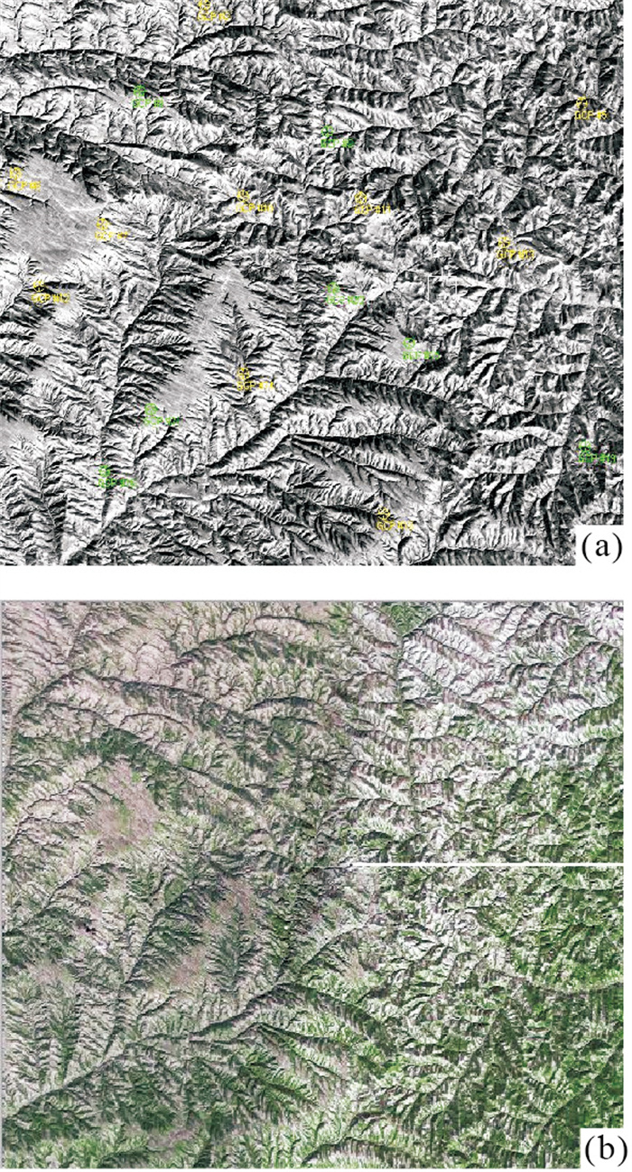
图 1 (a) IRS-P5原始影像和(b)SPOT-5参考影像
Fig. 1. (a) original IRS-P5 image and (b) reference SPOT-5 image
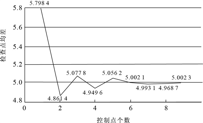
图 3 检查点(利用控制点实验)均差精度曲线
Fig. 3. Equal error accuracy curve of check points (using control points)
表 1 RPC模型参数形式
Table 1. Format of RPC model paramter
形式 分母 阶数 RPC参数数目 最小控制点数 1 1 14 7 2 PX≠PY 2 38 19 3 3 78 39 4 1 11 6 5 PX=PY≠1 2 29 15 6 3 59 30 7 1 8 4 8 PX=PY=1 2 20 10 9 3 40 20  下载: 导出CSV
表 2 无控制点的正射校正地面精度(m)
Table 2. Ground accuracy of ortho correction without control point
X方向 Y方向 Z方向 最大残差 -53.60 -27.52 60.25 最小残差 -39.56 -29.90 49.59 中误差 46.00 31.60 55.80
下载: 导出CSV
表 3 仿射变换模型的正射校正地面精度(m)
Table 3. Ground accuracy of ortho correction with affine transformation model
X方向 Y方向 Z方向 最大残差 -7.60 4.07 8.62 最小残差 -0.92 -0.35 0.98 中误差 3.53 2.06 4.09
下载: 导出CSV
-
Gao, W., 2006. Image fusion based on trous wavelet transfrom. Earth Science—Journal of China University of Geosciences, 31(Suppl. ): 132-135 (in Chinese with English abstract). http://en.cnki.com.cn/Article_en/CJFDTOTAL-DQKX200203024.htm Hu, Y., Tao, C.V., 2001. Updating solutions of the rational function model using additonal control points for enhanced photogrammetric processing. Proceedings of ISPRS joint workshop "high resolution mapping from space". Hanover, Germany. Li, D.R., Zhang, G., Jian, W.S., et al., 2006. SPOT-5 HRS satellite imagery block adjustment without GCPS or with single GCP. Geomatics and Information Science of Wuhan University, 31(5): 377-381 (in Chinese with English abstract). http://www.cnki.com.cn/Article/CJFDTotal-WHCH200605001.htm Liu, X.G., Hua, W.H., 2002. Analysis of GeoTag fields in GeoTiff. Earth Science—Journal of China University of Geosciences, 27(3): 246-249 (in Chinese with English abstract). Qin, X.W., Tian, S.F., Hong, Y.T., et al., 2005. Thealgorithm for parameters of RPC model without initial value. Remote Sensing for Land & Resouces, 4: 7-10 (in Chinese with English abstract). http://en.cnki.com.cn/Article_en/CJFDTOTAL-GTYG200504001.htm Tao, C.V., Hu, Y., 2000. Investigation on the rational fuction model. Proceedings of ASPRS Annual Convention, Washington, D.C., 359-366. Yang, X., 2000. Accuracy of rational function approximation in photogrammetry. Proceeding of ASPRS Annual Convention, Washington, D.C., 22-26. Yu, J.J., Huang, J., 2007. Remote sensing research and accuracy analysis based on IRS-P5. Jiangsu Province Society of Geodesy Photogrammety and Cartography, Nanjing, 237 (in Chinese). Zhang, Y.S., Liu, J., 2004. The positioning algorithm based on RPC model and its optimizing of stereo images from high resolution remote sensing satellites. Engineer of Surveying and Mapping, 13(1): 1-4 (in Chinese with English abstract). http://www.researchgate.net/publication/281400280_The_positioning_algorithm_based_on_RPC_model_and_its_optimizing_of_stereo_images_from_high_resolution_remote_sensing_satellites Zhao, L.P., Liu, F.D., Li, J., et al., 2007. Preliminary research on position accuracy of IRS-P5. Remote Sensing Information, 2: 28-32 (in Chinese with English abstract). http://www.zhangqiaokeyan.com/academic-journal-cn_remote-sensing-information_thesis/0201254406146.html 高伟, 2006. IKONOS影像融合技术及其在土地监测中的应用. 地球科学——中国地质大学学报, 31(增刊): 132-135. https://www.cnki.com.cn/Article/CJFDTOTAL-CHKD200702046.htm 李德仁, 张过, 江万寿, 等, 2006. 缺少控制点的SPOT-5 HRS影像RPC模型区域网平差. 武汉大学学报(信息科学版), 31(5): 377-381. https://www.cnki.com.cn/Article/CJFDTOTAL-WHCH200605001.htm 刘修国, 花卫华, 2002. GeoTiff中GeoTag域解析. 地球科学——中国地质大学学报, 27(3): 246-249. https://www.cnki.com.cn/Article/CJFDTOTAL-DQKX200203001.htm 秦绪文, 田淑芳, 洪友堂, 等, 2005. 无需初值的RPC模型参数求解算法研究. 国土资源遥感, 4: 7-10. https://www.cnki.com.cn/Article/CJFDTOTAL-GTYG200504001.htm 虞继进, 黄健, 2007. 基于IRS-P5遥感影像的实验与精度分析. 华东地区第十次测绘学术交流大会论文集, 南京, 237. 张永生, 刘军, 2004. 高分辨率遥感卫星立体影像RPC模型定位的算法及其优化. 测绘工程, 13(1): 1-4. https://www.cnki.com.cn/Article/CJFDTOTAL-CHGC200401000.htm 赵利平, 刘凤德, 李健, 等, 2007. 印度测图卫星IRS-P5定位精度初步研究. 遥感信息, 2: 28-32. https://www.cnki.com.cn/Article/CJFDTOTAL-YGXX200702007.htm -

 点击查看大图
计量
- 文章访问数: 3851
- HTML全文浏览量: 610
- PDF下载量: 52
- 被引次数: 0
