


Review on Applications of LiDAR Mapping Technology to Geosciences
-
摘要: 对激光雷达测量技术在全球冰川监测、局部断裂带提取、滑坡监测和稳定性评价以及海岸线提取和海岸侵蚀等方面的应用做了较为全面的综述.作为一种新型的对地观测手段,激光雷达(含星载、机载、车载和地面)的应用已经从传统的测绘扩大到包括文物保护在内的诸多其他应用领域.所综述的激光雷达技术在地学研究中的4个应用方面,是传统地学研究中与全球变化和人居环境最为密切的方向.分析表明,激光雷达技术在这些研究方向中的应用大有作为.
-
关键词:
- 激光雷达(LiDAR) /
- 冰川 /
- 断裂 /
- 滑坡 /
- 海岸侵蚀和海岸线
Abstract: This paper reviews the applications of laser mapping technology in the fields of global glacier analysis and monitoring, local and large scale faults extraction, landslide mapping and susceptibility assessment, shoreline detection and coastal erosion monitoring. As a new type of air-or-space borne remote sensing sensor, the application of laser mapping technology (including spaceborne, airborne, vehicle-based and terrestrial) has been extended from conventional surveying and precision surveying to such various fields as cultural heritage protection. The four application fields reviewed in the paper are four major research topics that are mostly related to human-environmental interaction. The review conclusion shows that the laser mapping technology should be or is becoming an indispensable tool for above mentioned issues.-
Key words:
- light detection and ranging (LiDAR) /
- glaciers /
- fault /
- landslides /
- coastal erosion and shoreline
-
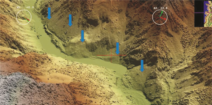
图 2 都-汶公路映秀镇附近数字表面模型(DSM)
数据由Leica ALS50II机载激光雷达在2008年5月31日获取,点密度为0.8点/km2.图中为原始点云数据高程配色的结果,可以判读出多个滑坡(图中箭头所示)
Fig. 2. Digital surface model (DSM) along Du-Wen highway in the vicinity of Yingxiu Town
表 1 几种类型激光雷达系统的简单比较
Table 1. Brief comparison among different types of LiDAR system
类型 平台 相对飞行高度 点云密度 精度 主要用途 主要型号 机载激光雷达 飞机(固定翼或直升机) 30~6 000 m 和多种因素有关.最大可以达到100点/m2以上 和多种因素有关.高程精度可以达到10 cm以下,平面精度可以达到10 cm左右 获取高精度数字表面模型和数字高程模型,可以应用于测绘、水利、林业、电力、城市规划等等多个领域 Leica ALS系列,Optech ALTM系列,TopoSys Harrier系列和Falcon系列,RIEGL LitterMapper系列等 车载激光雷达 汽车 每m2几百个点以上 平面和水平精度略高于机载激光雷达系统 主要是对地物的侧面进行激光扫描 英国StreetMapper系统,Optech lynx系统等 地面激光雷达 地面固定站点 每平方米可以达上千个点 平面和水平精度可以达到毫米,甚至亚毫米级 用于物体精细三维建模.广泛应用于工业测量、文物考古、建筑物建模等领域 主要由Leica、Optech、RIEGL等公司供应 星载激光雷达 卫星 400~600 km 光斑直径60~70 m,点间距170 m 垂直精度15 cm 全球植被、极地冰川、大气等研究领域 主要是美国NASA发射ICESat卫星上的GLAS激光雷达  下载: 导出CSV
-
Arrowsmith, J.R., Zielke, O., 2009. Tectonic geomorphology of the San Andreas fault zone from resolution topography: an example from the Cholame segment. Geomorphology, 113: 10-81. doi: 10.1016/j.geomorph.2009.01.002 Axelsson, P., 1999. Processing of laser scanner data—algorithms and applications. ISPRS Journal of Photogrammetry and Remote Sensing, 54: 138-147. doi: 10.1016/S0924-2716(99)00008-8 Baltsavias, E.P., 1999. A comparison between photogrammetry and laser scanning. ISPRS Journal of Photogrammetry & Remote Sensing, 54: 83-94. doi: 10.1016/S0924-2716(99)00014-3 Begg, J.G., Mouslopoulou, V., 2010. Analysis of Late Holocene faulting within an active rift using LiDAR, Taupo rift, New Zealand. Journal of Volcanology and Geothermal Research, 190: 152-167. doi: 10.1016/j.jvolgeores.2009.06.001 Bindschadler, R., Choi, H., 2005. Detecting and measuring new snow accumulation on ice sheets by satellite remote sensing. Remote Sensing of Environment, 98: 388-402. doi: 10.1016/j.rse.2005.07.04 Boak, E.H., Turner, I.L., 2005. Shoreline definition and detection: a review. Journal of Coastal Research, 21(4): 688-703. doi: 10.2112/03-0071.1 Booth, A.M., Roering, J.J., Perron, J.T., 2009. Automated landslide mapping using spectral analysis and high-resolution topographic data: Puget Sound lowlands, Washington, and Portland Hills, Oregon. Geomorphology, 109: 132-147. doi: 10.1016/j.geomorph.2009.02.027 Chang, K.J., Taboada, A., Chan, Y.C., 2005. Geological and morphological study of the Jiufengershan landslide triggered by the Chi-Chi Taiwan earthquake. Geomorphology, 71: 293-309. doi: 10.1016/j.geomorph.2005.02.004 Chust, G., Galparsoro, I., Borja, A., et al., 2008. Coastal and estuarine habitat mapping, using LiDAR height and intensity and multi-spectral imagery. Estuarine, Coastal and Shelf Science, 78(4): 633-643. doi: 10.1016/j.ecss.2008.02.003 Chust, G., Grande, M., Galparsoro, I., et al., 2010. Capabilities of the bathymetric Hawk Eye LiDAR for coastal habitat mapping: a case study within a Basque estuary. Estuarine, Coastal and Shelf Science, 89(3): 200-213. doi: 10.1016/j.ecss.2010.07.002 Dietrich, W.E., Bellugi, D., de Asua, R.R., 2001. Validation of the shallow landslide model, SHALSTAB, for forest management. In : Wigmosta, M.S., Burges, S.J., eds., Land use and watersheds: human influence on hydrology and geomorphology in urban and forest areas. American Geophysical Union Water Science and Application, 2: 195-227. Fricker, H.A., Padman, L., 2006. Ice shelf grounding zone structure from ICESat laser altimetry. Geophysical Research Letters, 33. doi: 10.1029/2006GL026907 Glenn, N.F., Streutker, D.R., Chadwick D.J., et al., 2006. Analysis of LiDAR-derived topographic information for characterizing and differentiating landslide morphology and activity. Geomorphology, 73: 131-148. doi: 10.1016/j.geomorph.2005.07.006 Harding, D.J., Berghoff, G.S., 2000. Fault scarp detection beneath dense vegetation cover: airborne LiDAR mapping of the Seattle fault zone, Bainbridge Island, Washington State. In: Proceedings of the American Society of Photogrammetry and Remote Sensing Annual Conference, Washington, D.C. . Harpold, R., Urban, T., Webb, C., Schutz, B., 2007. Assessment of ICESat repeat track estimation techniques for polar elevation change detection. American Geophysical Union, Fall Meeting 2007. http://adsabs.harvard.edu/abs/2007AGUFM.C23A0943H Haugerud, R.A., Harding, D.J., Johnson, S.Y., et al., 2003. High-resolution LiDAR topography of the Puget Lowland, Washington. GSA TODAY. http://www.researchgate.net/publication/250948935_High-Resolution_Lidar_Topography_of_the_Puget_Lowland_Washington_-A_Bonanza_for_Earth_Science Hudnut, K.W., Borsa, A., Glennie, C., et al., 2002. High-resolution topography along surface rupture of the 16 October 1999 Hector Mine, California, Earthquake (Mw 7.1) from airborne laser swath mapping. Bulletin of the Seismological Society of America, 92(4): 1570-1576. doi: 10.1785/0120000934 Inada, R., Takagi, M., 2010. Method of landslide measurement by ground based LiDAR. International Archives of the Photogrammetry, Remote Sensing and Spatial Information Science, XXXVIII(Part 8). http://www.researchgate.net/publication/264855391_METHOD_OF_LANDSLIDE_MEASUREMENT_BY_GROUND_BASED_LIDAR Liu, H., Sherman, D., Gu, S., 2007. Automated extraction of shorelines from airborne light detection and ranging data and accuracy assessment based on Monte Carlo simulation. Journal of Coastal Research, 23(6): 1359-1369. doi: 10.2112/05-0580.1 Ma, H.C., Yao, C.J., Zhang, S.D., 2008. Some technical issues of airborne LiDAR system applied to Wenchuan Earthquake relief works. Journal of Remote Sensing, (6): 925-932 (in Chinese with English abstract). http://en.cnki.com.cn/Article_en/CJFDTOTAL-YGXB200806014.htm Muskett, R.R., Lingle, S.C., 2008. Acceleration of surface lowering on the tidewater glaciers of Icy Bay, Alaska, U.S.A. from InSAR DEMs and ICESat altimetry. Earth and Planetary Science Letters, 265: 345-359. doi: 10.1016/j.epsl.2007.10.012 Nguyen, A.T., Herring, T.A., 2005. Analysis of ICESat Data using Kalman filter and Kriging to study surface height changes and surface characteristics in East Antarctica. Geophysical Research Letters, 32. doi: 10.1029/2005GL024272 Robertson, W.V., Whitman, D., Zhang, K.Q., et al., 2004. Mapping shoreline position using airborne laser altimetry. Journal of Coastal Research, 26(4): 884-892. doi: 10.2112/1551-5036(2004)20[884:MSPUAL]2.0.CO;2 Robertson, W.V., Zhang, K.Q., Whitman, D., 2007. Hurricane-induced beach change derived from airborne laser measurements near Panama City, Florida. Marine Geology, 237(3-4): 191-205. doi: 10.1016/j.margeo.2006.11.003 Roering, J.J., Stimely, L.L., Mackey, B.H., et al., 2009. Using DInSAR, airborne LiDAR, and archival air photos to quantify landsliding and sediment transport. Geophysical Research Letters, 36. doi: 10.1029/2009GL040374 Ruggiero, P., 2000. Beach monitoring in the Columbia River littoral cell, 1997-2000. Washington State Department of Ecology, Coastal Monitoring & Analysis Program, Publication No. 00-06-26, 112. Schulz, W.H., 2007. Landslide susceptibility revealed by LiDAR imagery and historical records, Seattle, Washington. Engineering Geology, 89: 67-87. doi: 10.1016/j.enggeo.206.09.019 Shen, J.S., Zhai, J.S., Guo, H.T., 2009. Study on coastline extraction technology. Hydrographic Surveying and Charting, 29(6): 72-77 (in Chinese with English abstract). http://en.cnki.com.cn/Article_en/CJFDTOTAL-HYCH200906022.htm Shrestha, R.L., Carter, W.E., Sartori, M., et al., 2005. Airborne laser swath mapping: Quantifying changes in sandy beaches over time scales of weeks to years. ISPRS Journal of Photogrammetry and Remote Sensing, 59(4): 222-232. doi: 10.1016/j.isprsjprs.2005.02.009 Slobbe, D.C., Lindenbergh, R.C., 2008. Estimation of volume change rates of Greenland's ice sheet from ICESat data using overlapping footprints. Remote Sensing of Environment, 112: 4204-4213. doi: 10.1016/j.rse.2008.07.004 Smith, B.E., Bentley, C.R., Raymond, C.F., 2005. Recent elevation changes on the ice streams and ridges of the Ross Embayment from ICESat crossovers. Geophysical Research Letters, 32. doi: 10.1029/2005GL024365 Stockdon, H.F., Sallenger, A.H., List, J.H., et al., 2002. Estimation of shoreline position and change using airborne topographic LiDAR data. Journal of Coastal Research, 18(3): 502-513. http://theowl.fsu.edu/jcr/article/download/81307/78447 Strurzenegger, M., Stead, D., Froese, C., et al., 2007. Ground based and airborne LiDAR for structural mapping of a large landslide: the Frank Slide. Proceedings of the 1st Canada-US rock mechanics Symposium, 27-31. http://www.researchgate.net/publication/285670157_Ground-based_and_airborne_LiDAR_for_structural_mapping_of_the_Frank_Slide Szekely, B., Zamolyi, A., Draganits, E., et al., 2009. Geomorphic expression of neotectonic activity in a low relief area in an airborne laser scanning DTM: a case study of the Little Hungarian Plain (Pannonian basin). Tectonophysics, 474: 353-366. doi: 10.1016/j.tecto.2008.11.024 Wechsler, N., Rockwell, T.K., YehudaBen-Zion, 2009. Application of high resolution DEM data to detect rock damage from geomorphic signals along the central San Jancinto fault. Geomorphology, 113: 82-96. doi: 10.1016/j.geomorph.2009.06.007 Wehr, A., Lohr, U., 1999. Airborne laser scanning—an introduction and overview. ISPRS Journal of Photogrammetry and Remote Sensing, 54: 68-82. doi: 10.1016/S0924-2716(99)00011-8 Wesche, C., Riedel, S., Steinhage, D., 2009. Precise surface topography of the grounded ice ridges at the Ekstromisen, Antarctica, based on several geophysical data sets. ISPRS Journal of Photogrammetry and Remote Sensing, 64(4): 381-386. doi: 10.1016/j.isprsjprs.2009.01.005 Woolard, J.W., Colby, J.D., 2002. Spatial characterization, resolution, and volumetric change of coastal dunes using airborne LiDAR: Cape Hatteras, North Carolina. Geomorphology, 48(1-3): 269-287. doi: 10.1016/S0169-555X(02)00185-X Xie, H., Ackley, S.F., 2010. Sea-ice thickness distribution of the Bellingshausen Sea from surface measurements and ICESat altimetry. Deep-Sea Research, doi: 10.1016/j.dsr2.2010.10.038 Yamamoto, K., Fukudo, Y., Doi, K., et al., 2008. Interpretation of the GRACE-derived mass trend in Enderby Land, Antarctica. Polar Science, 2: 267-276. doi: 10.1016/j.polar.2008.10.001 Yamanokuchi, T., Doi, K., 2010. Combined use of InSAR and GLAS data to produce an accurate DEM of the Antarctic ice sheet: example from the Breivikae Asuka station area. Polar Science, 4: 1-17. doi: 10.1016/j.polar.2009.12.002 Zhang, Y.H., 1996. Erosion hazards and their control in coastal regions of China. Journal of Catastrophology, 11(3): 15-21 (in Chinese with English abstract). http://en.cnki.com.cn/Article_en/CJFDTOTAL-ZHXU603.003.htm 马洪超, 姚春静, 张生德, 2008. 机载激光雷达在汶川地震应急响应中的若干关键问题探讨. 遥感学报, (6): 925-932. https://www.cnki.com.cn/Article/CJFDTOTAL-YGXB200806014.htm 申家双, 翟京生, 郭海涛, 2009. 海岸线提取技术研究. 海洋测绘, 29(6): 72-77. https://www.cnki.com.cn/Article/CJFDTOTAL-HYCH200906022.htm 张裕华, 1996. 中国海岸侵蚀危害及其防治. 灾害学, 11(3): 15-21. https://www.cnki.com.cn/Article/CJFDTOTAL-ZHXU603.003.htm -

 点击查看大图
图(2) / 表(1)
计量
- 文章访问数: 772
- HTML全文浏览量: 648
- PDF下载量: 23
- 被引次数: 0
