


The Stratigraphic System of the Zengmu Basin, Southern South China Sea
-
摘要: 曾母盆地是南沙海区研究和勘探程度较高的盆地, 其地层系统一直是建立整个南沙海区地层系统的重要依据.然而由于盆地沉积厚度大和横向相变快等原因, 对曾母盆地的分层方案和地层时代的认识存在很大分歧.为了给曾母盆地甚至南沙海区的油气勘探中地层划分对比和地震剖面的解释提供基础依据, 在搜集整理和分析国外有钻井控制的地震剖面和分层方案的基础上, 提出了一个实用的、便于与南海北部盆地对比的曾母盆地地层划分对比方案.将中海油对南海北部诸盆地制定的一套地层界面编号系统和地矿部广州海洋地质局对曾母盆地地层的命名结合起来, 并根据国外在曾母盆地获得的钻探和联井地震测线资料对界面的时代作了一定调整, 将曾母盆地基底以上的地层划分为4组1群(曾母组、立地组、海宁组、南康组、北康群), 之间由5个重要不整合面(Tg、T60、T40、T32、T30) 相分隔.还将该方案与国内外其他方案进行了对比和讨论, 以供阅读有关资料时参考.为了方便将这套地层系统应用于地震剖面的解释和分析, 用实例显示了同一地层中由于地层相变而造成的地震相的巨大变化, 以及各重要不整合面的特征及其在地震剖面上的表现.Abstract: The Zengmu basin is a well-studied hydrocarbon-bearing basin in the Nansha area of the southern South China Sea.The stratigraphic system of the Zengmu basin has been an important element for building regional stratigraphic system.However, the large thickness and quick changes of the strata facies have made it difficult and controversial to divide and date the basin.In order to provide basis for stratigraphic division and correlation in hydrocarbon exploration, we analyze existing data from wells and seismic profiles as well as proposed stratigtraphic columns, and propose a stratigraphic system that is comparable with that used in the exploration of the northern South China Sea.This system combines the numbering system of the CNOOC and the nomenclature of the GMGS, and date the stratigraphic boundaries with existing wells and cross-well seismic profiles.The strata above the basement are divided into four formations and one group (the Zengmu, Lidi, Haining, and Nankang Formations, and the Beikang Group), which are bottomed by five unconformities (Tg, T60, T40, T32, and T30).In order to facilitate the application of this stratigraphic system, the comparison of this scheme with other schemes is also presented, and facies changes within a formation and characteristic unconformities between formations are demonstrated by seismic profiles.
-
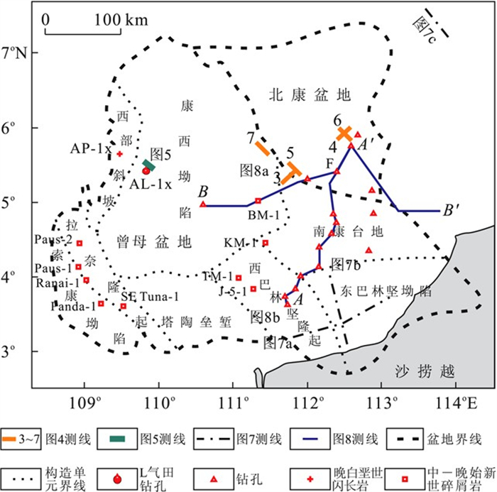
图 1 曾母盆地构造分区及本文涉及的钻孔和剖面分布(构造分区据白志琳等, 2003)
Fig. 1. Structure divisions and locations of wells and profiles in the Zengmu basin, southern South China Sea
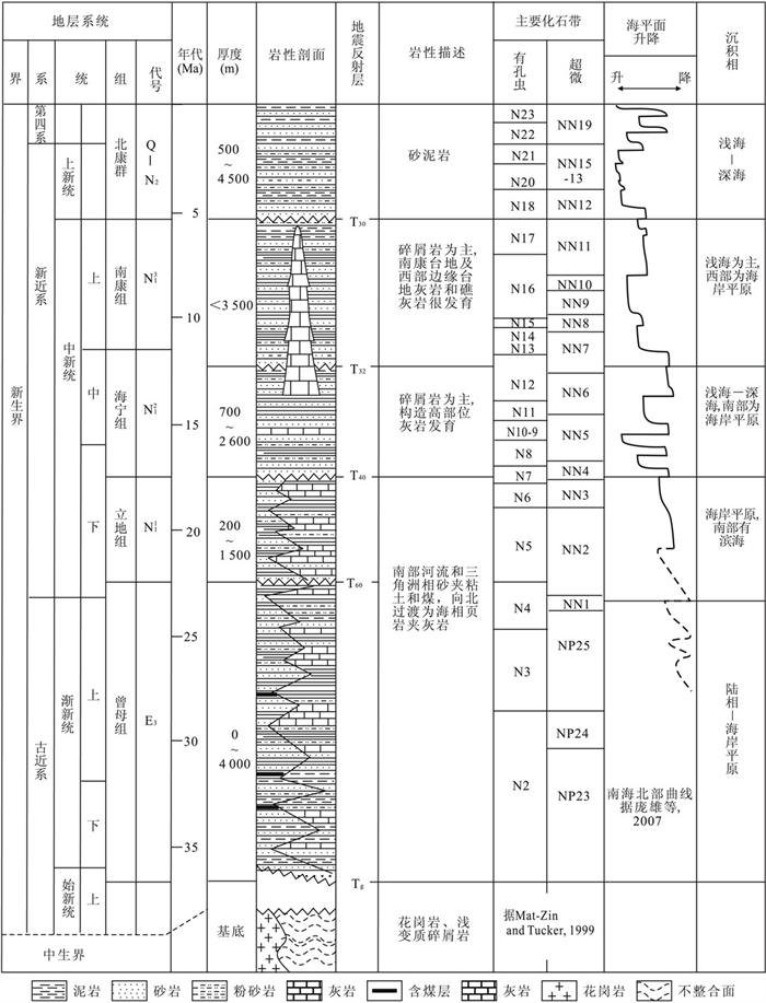
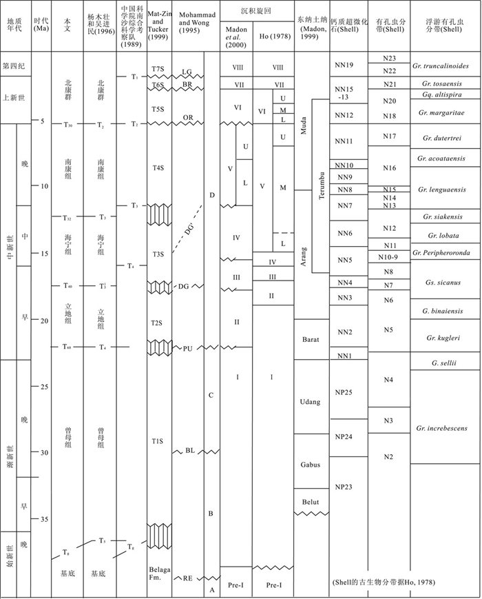
图 2 曾母盆地综合地层柱状图
Fig. 2. Composite stratigraphic column for the Zengmu basin, southern South China Sea
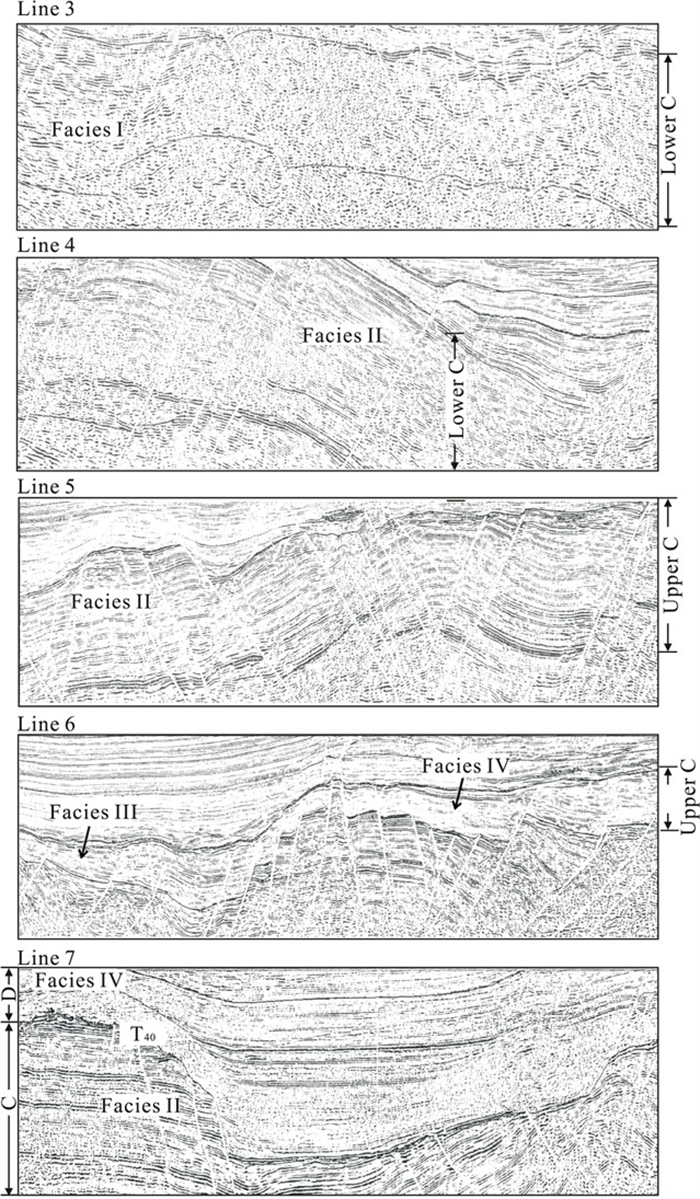
图 4 曾母盆地地震剖面, 示与岩相变化相对应的地震相变化(Mohammad and Wong, 1995)
FaciesⅠ、FaciesⅡ、FaciesⅢ、FaciesⅣ分别为河湖相、海岸及内浅海相、浅海相、半深海相(详见表 2); 层序C (图 3) 相当于T60与T40之间的下中新统立地组; 本文采用界面编号
Fig. 4. Seismic sections showing the facies changes in the Zengmu basin
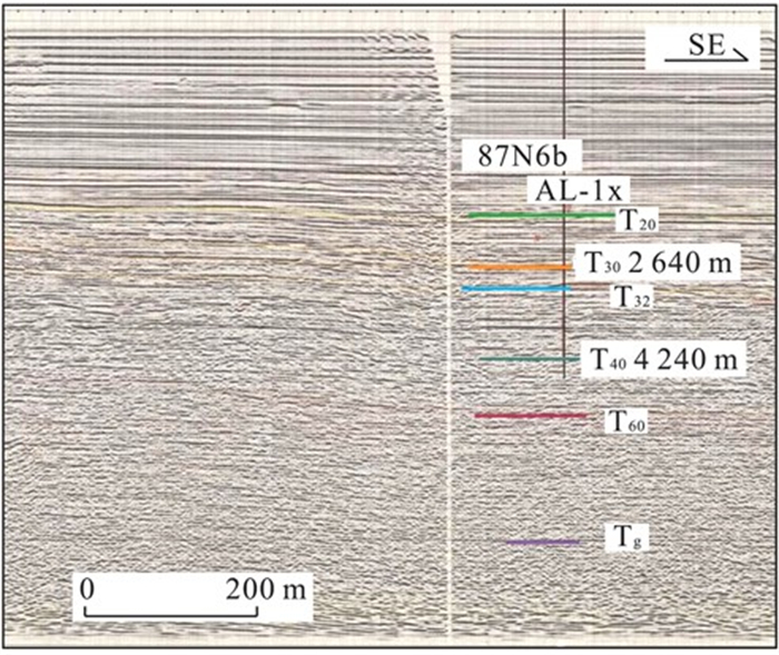
图 5 曾母盆地87N6剖面东段AL-1x井附近的地震反射特征及地层划分(剖面据中国科学院南沙综合科学考察队, 1989; 位置见图 1)
Fig. 5. Sections of line 87N6 near the well AL-1x in the Zengmu basin, showing the stratigraphic correlations
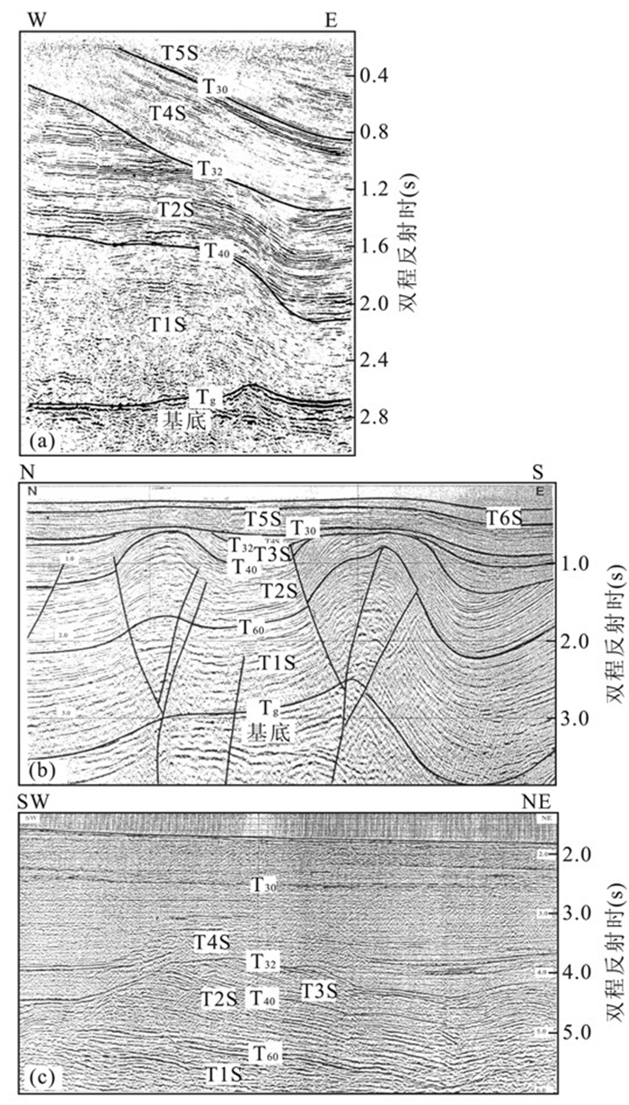
图 6 曾母盆地陆上(a)、浅海(b) 及深水区(c) 地震剖面(据Mat-Zin and Tucker, 1999)
本文采用的是界面编号; 注意图 6c剖面上T32以下古潜山的地层被削蚀约2 km
Fig. 6. Seismic sections in land (a), offshore (b), and in deep water area (c)
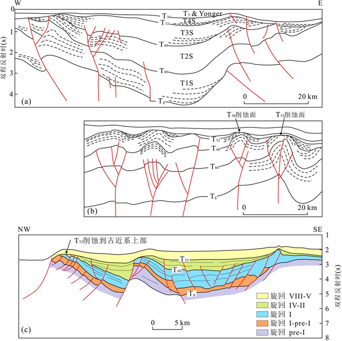
图 7 曾母盆地东部地震解释剖面
图 7a、7b据Mat-Zin and Tucker, 1999;图 7c据Ismall et al., 1995重绘; 均加注本文采用的界面编号, 其中T81指上始新统下界面; 剖面位置见图 1
Fig. 7. Geological sections in eastern Zengmu basin
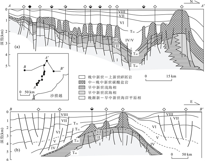
图 8 曾母盆地综合地质剖面(据Madon, 2000; 加注本文采用的界面编号; 剖面位置见图 1)
Fig. 8. Geological sections in the Zengmu basin
表 1 曾母盆地基底钻井分布
Table 1. Wells penetrated the basement of the Zengmu basin
钻井名 经度(°E) 纬度(°N) 样深(m) 岩性 时代(Ma) 文献 AY-1x 109.469 5.619 2 811 火山集块岩 54.6±2.7 杨木壮和吴进民, 1996 AP-1x 109.617 5.517 4 199 闪长岩 79.3±4.7 杨木壮和吴进民, 1996; Hutchison, 1989 Paus-2 108.933 4.454 1 426 千枚岩、板岩 K-E2 (?) 杨木壮和吴进民, 1996; Hutchison, 1989 Paus-1 108.896 4.139 2 564 黑云母千枚岩 K-E2 杨木壮和吴进民, 1996; Hutchison, 1989 Ranai-1 109.097 3.932 2 335 千枚状页岩、凝灰质粉砂岩 E2 杨木壮和吴进民, 1996; Hutchison, 1989 Panda-1 109.276 3.594 2 456 片岩 Mz?E2? 杨木壮和吴进民, 1996; Hutchison, 1989 SE Tuna-1 109.509 3.666 2 590 千枚岩 E2 杨木壮和吴进民, 1996 BM-1 111.336 5.028 3 062 碎屑岩 E3 杨木壮和吴进民, 1996 KM-1 111.395 4.359 3 304 碎屑岩 E3 杨木壮和吴进民, 1996 TM-1 111.146 3.996 2 864 碎屑岩 E2 杨木壮和吴进民, 1996 J-5-1 111.278 3.823 2 054 千枚岩 E2 杨木壮和吴进民, 1996  下载: 导出CSV
表 2 曾母盆地地震相特征(据Mohammad and Wong, 1995)
Table 2. 2 Seismic facies and their features in the Zengmu basin
名称 代号 岩性 地震相特征 河湖相 Facies I 碎屑岩 亚平行至楔状, 断续至亚连续, 不规则至波状反射 海岸及内浅海相 Facies II 砂岩、页岩互层 平行、亚平行至楔形, 连续, 高振幅强反射 浅海相 Facies III 页岩, 夹灰岩 平行反射过渡到下伏透明至杂乱反射以及丘状反射 半深海相 Facies IV 页岩为主, 含浊积岩 透明至杂乱反射, 夹丘状反射
下载: 导出CSV
-
[1] Bai, Z. L., Gao, H. F., Wang, H. J., et al., 2003. The study of subsiding history of local structures in the west of Zengmu basin, South China Sea. Geological Research of South China Sea, 15: 92-98(in Chinese with English abstract). http://en.cnki.com.cn/Article_en/CJFDTotal-NHDZ200300002.htm [2] Chen, H. W., Liang, S. R., 2004. Progress of gas-oil prospec-ting at Zengmu basin, Nansha, South China Sea. In: Guangzhou Marine Geological Survey, ed., Geological studies in the South China Sea. Geological Publishing House, Beijing, 92-98 (in Chinese). [3] Du Bois, E. P., 1985. Review of principal hydrocarbon-bearing basins of the South China Sea area. Geol. Soc. Malaysia Bull., 18: 167-209. doi: 10.7186/bgsm18198508 [4] Ho, K. F., 1978. Stratigraphic framework for oil explorationin Sarawak. Geol. Soc. Malaysia Bull., 10: 1-13. doi: 10.7186/bgsm10197801 [5] Houtz, R. E., Haye, D. E., 1984. Seismic refraction data fromSunda shelf. AAPG Bulletin, 68(12): 1870-1878. doi: 10.1306/AD4619F3-16F7-11D7-8645000102C1865D. [6] Hutchison, C. S., 1989. Geological evolution of South-eastAsia. Clarendon Press, Oxford, 368. [7] Ismall, m. I., Eusoff, A. R., Mohammad, A. M., et al., 1995. The geology of Sarawak deepwater and surrounding areas. Geol. Soc. Malaysia Bull., 37: 165-178. doi: 10.7186/bgsm37199512 [8] Leong, K. M., 2000. The petroleum geology and resources ofMalaysia. Petronas(Petroliam Nasional Berhad), KualaLumpur, 665. [9] Madon, M. B. H., 1999. Basin types, tectono-stratigraphic provinces, and structural styles. In: Leong, K. M., ed., The petroleum geology and resources of Malaysia. Petronas(Petroliam Nasional Berhad), Kuala Lumpur, 77-111. [10] Madon, M. B. H., 2000. Geological setting of Sarawak. In: Leong, K. M., ed., The petroleum geology and resources of Malaysia. Petronas(Petroliam Nasional Berhad), Kuala Lumpur, 275-290. [11] Madon, M. B. H., Karim, R. B. A., Fatt, R. W. H., 2000. Tertiary stratigraphy and correlation schemes. In: Leong, K. M., ed., The petroleum geology and resourcesof Malaysia. Petronas(Petroliam Nasional Berhad), Kuala Lumpur, 115-137. [12] Mat-Zin, I. C., Tucker, M. E., 1999. An alternative stratigraphic scheme for the Sarawak basin. J. Asian Earth Sci., 17(1-2): 215-232. doi: 10.1016/S0743-9547(98)00042-7. [13] Mohammad, A. M., Wong, R. H. F., 1995. Seismic sequence stratigraphy of the Tertiary sediments, offshore Sarawak deepwater area, Malaysia. Geol. Soc. Malaysia Bull., 37: 345-361. doi: 10.7186/bgsm37199526 [14] Nansha Expedition of the Chinese Academy of Sciences, 1989. Reports on the composite investigation in Nansha Islands and adjacent sea areas(I). Science Press, Beijing, 294(in Chinese). [15] Pang, X., Chen, C. M., Peng, D. J., et al., 2007. The Pearl River deep-water fan system & petroleum in South China Sea. Science Press, Beijing, 361(in Chinese). [16] Williams, G. L., Bujak, J. P., 1985. Mesozoic and Cenozoic dinoflagellates. In: Bolli, H. M., Saunders, J. B., PerchNielsen, K., eds., Plankton stratigraphy. CambridgeUniv. Press, Cambridge. [17] Yang, M. Z., Wu, J. M., 1996. The stratigraphy of the Zengmu basin. Marine Geology and Quaternary Geology, 17: 18-27(in Chinese). [18] 白志琳, 高红芳, 王后金, 等, 2003. 曾母盆地西部典型构造沉降史研究. 南海地质研究, 15: 92-98. https://www.cnki.com.cn/Article/CJFDTOTAL-NHDZ200300002.htm [19] 陈宏文, 梁世容, 2004. 南沙海域曾母盆地的油气勘探开发现状. 见: 国土资源部广州海洋地质调查局, 编. 南海地质研究. 北京: 地质出版社, 92-98. [20] 庞雄, 陈长民, 彭大钧, 等, 2007. 南海珠江深水扇系统及油气. 北京: 科学出版社, 361. [21] 杨木壮, 吴进民, 1996. 曾母盆地地层发育特征. 海洋地质与第四纪地质, 1(17): 18-27. [22] 中国科学院南沙综合科学考察队, 1989. 南沙群岛及其邻近海区综合调查研究报告(一), 上卷. 北京: 科学出版社, 294. -

 点击查看大图
计量
- 文章访问数: 3616
- HTML全文浏览量: 1133
- PDF下载量: 82
- 被引次数: 0
