


Seismic Response and Development of Carbonate Platform in Liyue Basin, Nansha Sea Area
-
摘要: 礼乐盆地位于南海南部的南沙地块, 自中生代以来, 经历了挤压、张裂、沉降和碰撞挤压等多期次构造过程, 发育众多的碳酸盐台地, 是一个很有勘探潜力的叠合盆地.根据位于礼乐盆地东北边缘的地震测线NH973-2, 结合部分已发表的钻井地震资料, 开展盆地的层序地层研究, 揭示了礼乐盆地的地层层序, 分析了礼乐台地的地震特征.礼乐滩碳酸盐台地具有典型的丘状外形和杂乱的内部反射特征.根据地震计算对礼乐地区的构造沉降分析, 划分了新生代盆地演化阶段, 指出构造作用控制了礼乐碳酸盐台地发育.Abstract: Liyue basin is located in the Nansha block of the South China Sea, which has been subject to compression, rifting, drifting and collision with Borneo block since Mesozoic.It is a complicated superimposed basin with great potential for exploration, with its well developed carbonate platforms being unique targets both for research and exploration.Based on new seismic profile NH973-2, in combination with published well and seismic data, the stratigraphic sequences across the section are analyzed in order to reveal the sedimentary sequences and seismic characters in the Liyue basin.The carbonate platforms are characterized by round external form, chaotic internal reflector.Based on tectonic subsidence calculation, we determine three stages of tectonic evolution in Liyue basin during Cenozoic and come to the conclusion that tectonic actions have had control over the development of Liyue carbonate platform.
-
Key words:
- Liyue basin /
- carbonate platform /
- stratigraphic sequences /
- stratigraphy /
- earthquakes /
- marine geophysics
-
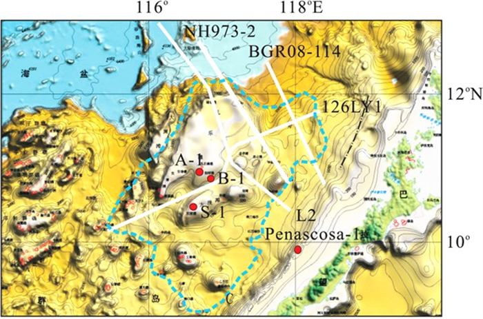
图 1 南沙海区礼乐盆地构造区划与文中涉及地震测线位置
虚线代表盆地边界; 白线代表文中讨论的地震剖面位置
Fig. 1. Tectonic division for Liyue basin in Nansha area and seismic line mentioned about in discussion
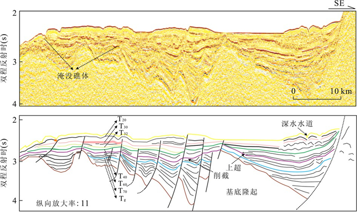
图 4 NH973-2南段地震剖面地层划分
Fig. 4. Stratigraphic sequences division for south seismic section of line NH973-2

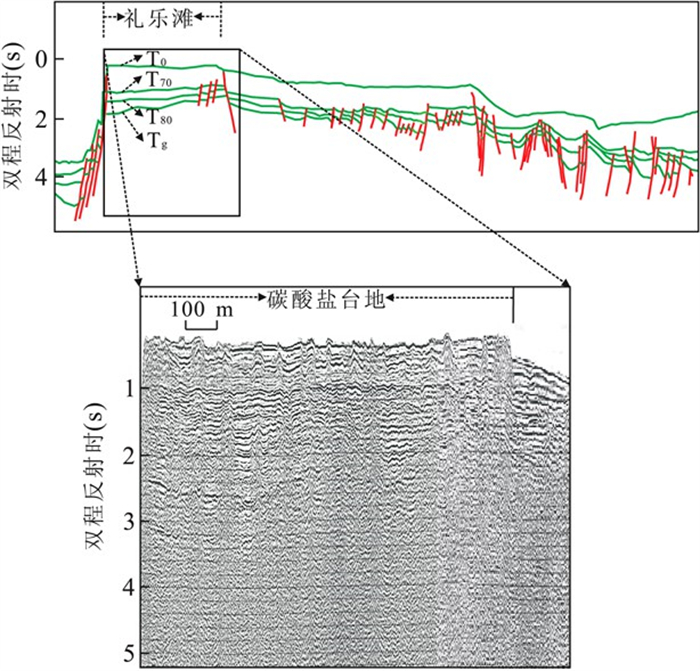
图 5 礼乐滩地震剖面及地质模型
a.反射地震剖面; b.中新世以来地层模型
Fig. 5. Seismic section and stratigraphic model for Liyue bank

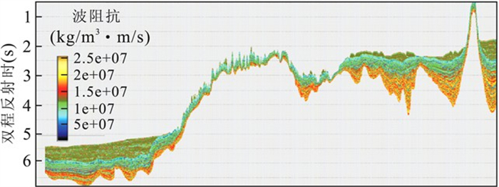
图 7 礼乐滩及盆地南部波阻抗反演结果
a.NH973-2测线礼乐滩碳酸盐台地的反演结果; b.盆地南部反演结果(图例同7a)
Fig. 7. Impedance inversion result for Liyue bank and South basin

图 8 根据NH973-2计算的区域构造沉降与全球海平面变化曲线(据Haq et al., 1987)
Fig. 8. Curves of tectonic subsidence according to line NH973-2 calculation and global sea level variation
-
[1] Briais, A., Patriat, P., Tapponnier, P., 1993. Updated interpretation of magnetic anomalies and seafloor spreading stages inthe South China Sea: implications for the Tertiary tectonicsof Southeast Asia. Journal of Geophysical Research, 98(B4): 6299-6328. doi: 10.1029/92JB02280. [2] Franke, D., Barckhausen, U., Baristeas, N., et al., 2011. Thecontinent-ocean transition at the southeastern margin of theSouth China Sea. Marine and Petroleum Geology, 28(6): 1187-1204. doi: 10.1016/j.marpetgeo.2011.01.004. [3] Gao, H. F., Zeng, X. H., Liu, Z. H., et al., 2005. Subsidencemodeling and tectonic evolution characteristics analysis ofLiyue basin in Nansha area. Tectonics and Metallogeny, 29(3): 385-390(in Chinese with English abstract). [4] Haq, B. U., Hardenbol, J., Vail, P. R., 1987. Chronology of fluctuating sea levels since the Triassic. Science, 235(4793): 1156-1167. doi: 10.1126/science.235.4793.1156. [5] Hinz, K., Schlüter, H. U., 1985. Geology of the dangerousgrounds, South China Sea, and the continental marginoff Southwest Palawan: results of SONNE Cruises SO-23and SO-27. Energy, 10(3-4): 297-315. doi: 10.1016/0360-5442(85)90048-9. [6] Holloway, N. H., 1982. North Palawan block Philippines—its relation to Asian mainland and role in evolution ofSouth China Sea. AAPG Bulletin, 66(9): 1355-1383. [7] Hutchison, C. S., 2004. Marginal basin evolution: the southern South China Sea. Marine and Petroleum Geology, 21(9): 1129-1148. doi: 10.1016/j.marpetgeo.2004.07.002. [8] Kudrass, H. R., Wiedicke, M., Cepeck, P., et al., 1986. Mesozoic and Cainozoic rocks dredged from the South China Sea (Reed bank area)and Sulu Sea and their significance for plate tectonic reconstructions. Marine and Petroleum Geology, 3(1): 19-30. doi: 10.1016/02648172(86)90053-X. [9] Müller, R. D., Lim, V. S. L., Isern, A. R., 2000. Late Tertiary tectonic subsidence on the Northeast Australian passive margin: response to dynamic topography. Marine Geology, 162(2-4): 337-352. doi: 10.1016/S00253227(99)00089-4. [10] Schlüter, H. U., Hinz, K., Block, M., 1996. Tectono-stratigraphic terranes and detachment faulting of the South China Sea and Sulu Sea. Marine Geology, 130(1-2): 39-78. doi: 10.1016/0025-3227(95)00137-9. [11] Sun, L. T., Sun, Z., Zhou, D., et al., 2008. Sedimentary stratigraphic and tectonic characteristics analysis of Liyuebasin in Nansha area. Tectonics and Metallogeny, 32(2): 151-158(in Chinese with English abstract). http://en.cnki.com.cn/Article_en/CJFDTOTAL-DGYK200802004.htm [12] Sun, L. T., Sun, Z., Zhan, W. H., et al., 2010. Oil and gasresource potential of Liyue basin in Nansha area. Journal of Earth Science, 35(1): 137-145(in Chinese withEnglish abstract). [13] Taylor, B., Hayes, D. E., 1980. The tectonic evolution of theSouth China Sea. In: Hayes, D. E., ed., The tectonic andgeologic evolution of Southeast Asian seas and islands. Geophys. Monograph, AGU, Washington, D. C., 23: 89-104. [14] Wilson, M. E. J., 2002. Cenozoic carbonates in SoutheastAsia: implications for equatorial carbonate development. Sedimentary Geology, 147(3-4): 295-428. doi: 10.1016/S0037-0738(01)00228-7. [15] Wu, S. G., Han, Q. H., Dong, D., et al., 2009. Petroleumsystem in deepwater basins of the northern South China Sea. Journal of Earth Science, 20(1): 124-135. doi: 10.1007/s12583-009-0014-3 [16] Xia, K. Y., 1996. Geologic geographic and oil/gas resource of inand out of Nansha islands. Science Press, Beijing, 252. [17] Yan, P., Liu, H. L., 2004. Tectonic-stratigraphic division andblind fold structures in Nansha waters, South China Sea. Journal of Asian Earth Sciences, 24(3): 337-348. doi: 10.1016/j.jseaes.2003.12.005 [18] Yao, Y. J., Jiang, Y. K., Zeng, X. H., 2002. Cenozoic tectonic characteristics of Nansha area. China Offshore Oil and Gas, 6(2): 113-117(in Chinese with English abstract). [19] Yu, K., Zhao, J., 2009. Coral reefs. In: Wang, P. X., Li, Q. Y., eds., The South China Sea: paleoceanography andsedimentology. Springer, Heidelberg, 229-255. [20] 高红芳, 曾祥辉, 刘振湖, 等, 2005. 南海礼乐盆地沉降史模拟及构造演化特征分析. 大地构造与成矿学, 29(3): 385-390. doi: 10.3969/j.issn.1001-1552.2005.03.014 [21] 孙龙涛, 孙珍, 周蒂, 等, 2008. 南沙海区礼乐盆地沉积地层与构造特征分析. 大地构造与成矿学, 32(2): 151-158. doi: 10.3969/j.issn.1001-1552.2008.02.003 [22] 孙龙涛, 孙珍, 詹文欢, 等, 2010. 南沙海域礼乐盆地油气资源潜力. 地球科学——中国地质大学学报, 35(1): 137-145. https://www.cnki.com.cn/Article/CJFDTOTAL-DQKX201001017.htm [23] 夏勘原, 1996. 南沙群岛及其邻近海区地质地球物理与油气资源. 北京: 科学出版社. [24] 姚永坚, 姜玉坤, 曾祥辉, 2002. 南沙海域新生代构造特征. 中国海上油气(地质), 16(2): 113-117. https://www.cnki.com.cn/Article/CJFDTOTAL-ZHSD200202009.htm -

 下载:
下载:


 点击查看大图
计量
- 文章访问数: 3655
- HTML全文浏览量: 732
- PDF下载量: 75
- 被引次数: 0
