


Crust Structure and Tectonostratigraphy of Liyue Block, Northeast of Nansha Area
-
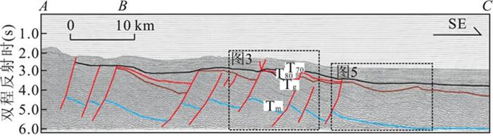
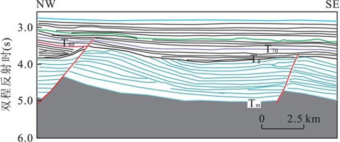
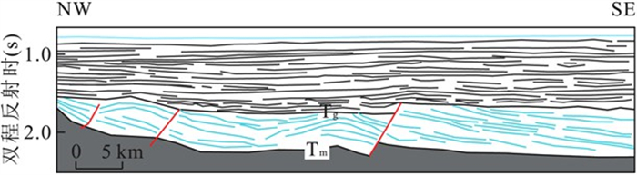
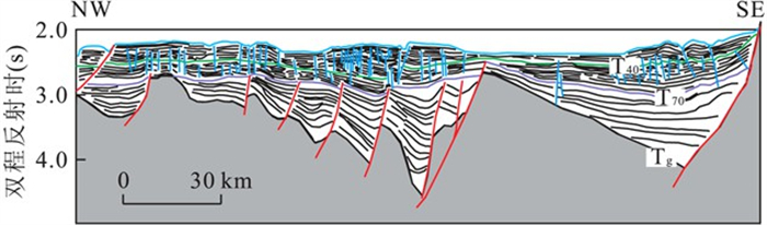
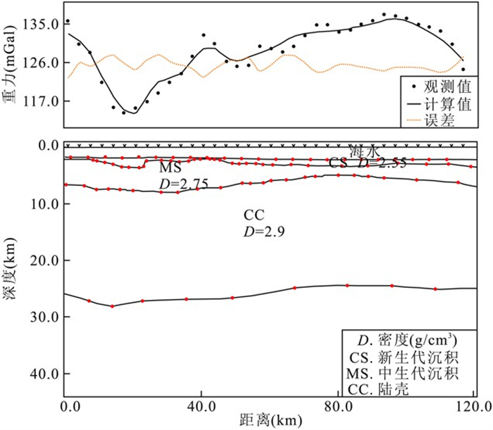
摘要: 礼乐地块位于南沙海域东北部, 主要由2部分组成: 礼乐滩和礼乐盆地.根据重力和地震数据研究礼乐地块的主要构造特征和地壳结构.基于多道地震数据, 主要研究了基底之上的地层和断裂构造, 并通过重力数据反演分析了地块深部地壳结构.礼乐滩区域主要为碳酸盐岩地层, 此区域地层较平, 断裂不发育.而礼乐盆地区域早期断裂较为发育, 并且主要发育2种构造: 翘倾断块和宽缓背斜; 中生代地层厚度自SW向NE减薄, 但张裂期地层自SW向NE增厚, 这表明在张裂阶段断层活动强度自SW向NE增强, 离张裂中心越近, 断裂活动强度越大.礼乐地块以正布格重力异常为主(60~140mGal), 莫霍面深度约16~27km, 拉张因子为1.3~2.0, 属于减薄型大陆地壳.Abstract: The Liyue block is composed of two parts, namely, Reed Bank and Liyue basin, which is separated by Zhongnan fault in west, Palawan trough in southeast and fault scarp in the north of Nansha area.Based on gravity and seismic data set, a systematic investigation on major tectonic and crust structure units in the Liyue block is made.Multichannel seismic data can better our understanding of the stratum and fault structure located in the sediment basement.In the Reed Bank, composed of reefs, the faults are undeveloped and the stratum is flat.In the basin area, the early faults are developed with two kinds of structures: tilted fault block and low relief anticline.The thickness of the Mesozoic strata in basin area decreases from SW to NE.But the thickness of rifting strata increases from SW to NE, which indicates the fault activity strength in the rift period increases from southwest to northeast.Gravity inversion is performed to understand the geometry of the MOHO surface and the crustal thicknesses beneath.The region is characterized by a large positive Bouguer gravity anomaly (60 to 140 mGal), and the MOHO depth generally varies from 16 to 27 km.In general, crustal structures can be distinguished from the thinned continental crust.The Liyue block is characterized by stretching factors ranging from 1.3 to 2.0, which indicates that the local region is lowly stretched.
-
Key words:
- Liyue block /
- gravity inversion /
- tectonics /
- crust structure /
- marine geology
-
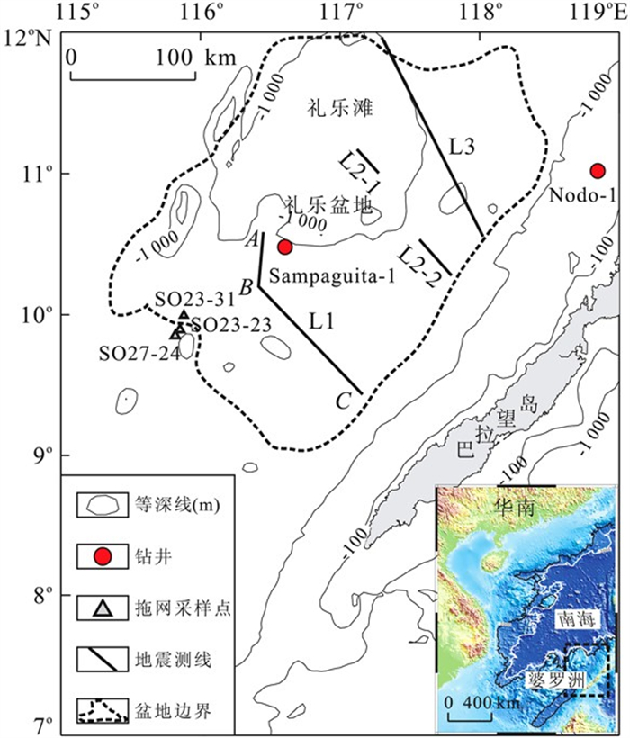
图 1 礼乐地块区域位置及地貌
Fig. 1. Map of the survey area and the location (solid box) of Liyue block
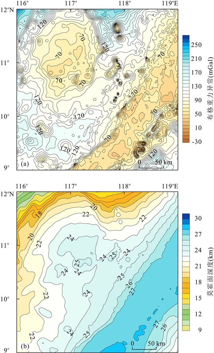
图 9 研究区布格重力异常(a) 和莫霍面深度(b) (莫霍面深度是相对海底的深度)
Fig. 9. Computed Bouguer gravity anomaly (a) and MOHO depth (b)
-
[1] Blakley, J., 1995. Potential theory in gravity and magnetics applications. Cambridge University Press, New York. [2] Briais, A., Patriat, P., Tapponnier, P., 1993. Updated interpretation of magnetic-anomalies and sea-floor spreading in the South China Sea: implications for the Tertiary tectonics of Southeast-Asia. Journal of Geophysical Research, 98(B4): 6299-6328. doi: 10.1029/92JB02280. [3] Clift, P., Lee, G. H., Duc, N. A., et al., 2008. Seismic reflection evidence for a dangerous grounds miniplate: no extrusion origin for the South China Sea. Tectonics, 27(3): 1-16. doi: 10.1029/2007TC002216. [4] Fournier, F., Borgomano, J., Montaggioni, L. F., 2005. Development patterns and controlling factors of Tertiary carbonatebuildups: insights from high-resolution 3D seismic and welldata in the Malampayagas field (Offshore Palawan, Philippines). Sedimentary Geology, 175(1-4): 189-215. doi: 10.1016/j.sedgeo.2005.01.009. [5] Hall, R., 2002. Cenozoic geological and plate tectonic evolution of SE Asia and the SW Pacific: computer-based reconstructions, model and animations. Journal of Asian Earth Sciences, 20(4): 353-431. doi: 10.1016/S1367-9120(01)00069-4. [6] Hao, H. J., Lin, H. M., Yang, M. X., et al., 2001. The Mesozoic in Chaoshan depression: a new domain of prtroleum exploration. China Offshore Oil and Gas (Geology), 15(3): 157-163 (in Chinese with English abstract). http://www.zhangqiaokeyan.com/academic-journal-cn_china-offshore-oil-gas-geological_thesis/0201219531911.html [7] Haq, B. U., Hardenbol, J., Vail, P. R., 1987. Chronology of fluctuating sea-levels since the Triassic. Science, 235(4793): 1156-1167. doi: 10.1126/science.235.4793.1156. [8] Hinz, K., Schluter, H. U., 1985. Geology of the dangerousgrounds, South China Sea, and the continental marginoff Southwest Palawan: results of SONNE cruises SO-23 and SO-27. Energy, 10(3-4): 297-315. doi: 10.1016/0360-5442(85)90048-9. [9] Holloway, N. H., 1982. North Palawan block, Philippines: its relation to Asian mainland and role in evolution of South China Sea. AAPG Bulletin, 66(9): 1355-1383. doi: 10.1306/03B5A7A5-16D1-11D78645000102C1865D. [10] Hutchison, C. S., 2004. Marginal basin evolution: the southern South China Sea. Marine and Petroleum Geology, 21(9): 1129-1148. doi: 10.1016/j.marpetgeo.2004.07.002. [11] Jin, Q. H., Li, T. G., 2000. Regional geologic tectonics of the Nansha Sea area. Marine Geology and Quaternary Geology, 20(1): 1-8 (in Chinese with English abstract). http://en.cnki.com.cn/Article_en/CJFDTOTAL-HYDZ200001000.htm [12] Kudrass, H. R., Wiedicke, M., Cepeck, P., et al., 1986. Mesozoic and Cenozoic rocks dredged from the South China Sea (Reed Bank area) and Sulu Sea and their significance for plate-tectonic reconstructions. Marine and Petroleum Geology, 3(1): 19-30. doi: 10.1016/02648172(86)90053-X. [13] Li, C. F., Zhou, Z. Y., Hao, H. J., et al., 2008. Late Mesozoic tectonic structure and evolution along the present-day northeastern South China Sea continental margin. Journal of Asian Earth Sciences, 31(4-6): 546-561. doi: 10.1016/j.jseaes.2007.09.004. [14] Nissen, S. S., Hayes, D. E., Yao, B. C., et al., 1995. Gravity, heat flow, and seismic constraints on the processes of crustal extension: northern margin of the South China Sea. Journal of Geophysical Research, 100(B11): 22447-22483. doi: 10.1029/95JB01868. [15] Parker, R. L., 1973. The rapid calculation of potential anomalies. Geophysical Journal International, 31(4): 447-455. doi: 10.1111/j.1365-246x.1973.tb06513.x. [16] Sales, A. O., Jacobsen, E. C., Morado, A. A., et al., 1997. The petroleum potential of deep-water Northwest Palawan block GSEC 66. Journal of Asian Earth Science, 15(2-3): 217-240. doi: 10.1016/S0743-9547(97)00009-3. [17] Schluter, H. U., Hinz, K, Block, M., 1996. Tectono-stratigraphic terranes and detachment faulting of the South China Sea and Sulu Sea. Marine Geology, 130(1-2): 39-78. doi: 10.1016/0025-3227(95)00137-9. [18] Sun, L. T., Sun, Z., Zhan, W. H., et al., 2010. Petroleum potential prediction of the Lile basin in Nansha. Earth Science—Journal of China University of Geosciences, 35(1): 137-145 (in Chinese with English abstract). doi: 10.3799/dqkx.2010.014 [19] Sun, L. T., Sun, Z., Zhou, D., et al., 2008. Stratigraphic and structural characteristics of Lile basin in Nansha area. Geotectonica et Metallogenia, 32(2): 151-158 (in Chinese with English abstract). http://en.cnki.com.cn/Article_en/ http://search.cnki.net/down/default.aspx?filename=DGYK200802004&dbcode=CJFD&year=2008&dflag=pdfdown [20] Taylor, B., Hayes, D. E., 1980. The tectonic evolution of the South China Sea basin. In: Hayes, D E., ed., The tectonic and geologic evolution of Southeast Asian Seas and islands. Geophysical Monograph, AGU, Washington, D. C., 23: 89-104. [21] Taylor, B., Hayes, D. E., 1983. Origin and history of the South China basin. In: Hayes, D. E., ed., The tectonic and geologic evolution of Southeast Asian seas and islands Part 2. Geophysical Monograph, AGU, Washington, D. C., 27: 23-56. [22] Wang, T. K., Chen, M. K., Lee, C. S., et al., 2006. Seismic imaging of the transitional crust across the northeastern margin of the South China Sea. Tectonophysics, 412(34): 237-254. doi: 10.1016/j.tecto.2005.10.039. [23] Wiliams, H. H., 1997. Play concepts-Northwest Palawan, Philippines. Journal of Asian Earth Sciences, 15(23): 251-73. doi: 10.1016/S0743-9547(97)00011-1. [24] Xia, K. Y., Huang, C. L., 2000. The discovery of meso-tethys sedimentay basins in the South China Sea and their oil and gas perspective. Earth Science Frontiers, 7(3): 227-238 (in Chinese with English abstract). http://www.researchgate.net/publication/285504858_The_discovery_of_Meso-Tethys_sedimentary_basins_in_the_South_China_Sea_and_their_oil_and_gas_perspective [25] Yan, P., Liu, H. L., 2004. Tectonic-stratigraphic division and blind fold structures in Nansha Waters, South China Sea. Journal of Asian Earth Sciences, 24(3): 337-348. doi: 10.1016/j.jseaes.2003.12.005. [26] Yan, P., Zhou, D., Liu, Z. S., 2001. A crustal structure profile across the northern continental margin of the South China Sea. Tectonophysics, 338(1): 1-21. doi: 10.1016/S0040-1951(01)00062-2. [27] Yang, S. C., Tong, Z. G., Hao, J. R., et al., 2009. Tectonothermal modeling of Lile basin, southern South China Sea. Geotectonica et Metallogenia, 33(3): 359-364 (in Chinese with English abstract). http://epub.cnki.net/grid2008/docdown/docdownload.aspx?filename=DGYK200903006&dbcode=CJFD&year=2009&dflag=pdfdown [28] Yao, B. C., Wan, L., Liu, Z. H., 2004. Tectonic dynamics of Cenozoic sedimentary basins and hydrocarbon resources in the South China Sea. Earth Science—Journal of China University of Geosciences, 29(5): 543-549 (in Chinese with English abstract). http://www.researchgate.net/publication/279756612_Tectonic_dynamics_of_Cenozoic_sedimentary_basins_and_hydrocarbon_resources_in_the_South_China_Sea [29] Yao, B. C., Wan, L., Zeng, W. J., 2006.3-D lithosphere structures and evolution of the South China Sea. Geological Publishing House, Beijing (in Chinese). [30] Yao, Y. J., Jiang, Y. K., Zeng, X. H., 2002. Cenozoic tectonic movements in Nansha area, South China Sea. China Offshore Oil and Gas (Geology), 16(2): 113-118 (in Chinese with English abstract). http://en.cnki.com.cn/Article_en/CJFDTOTAL-ZHSD200202009.htm [31] Zhang, L., Li, W. C., Zeng, X. H., 2003. Stratigraphic sequence and hydrocarbon potential in Lile basin. Petroleum Geology and Experiment, 25(5): 69-573 (in Chinese with English abstract). http://www.zhangqiaokeyan.com/academic-journal-cn_petroleum-geology-experiment_thesis/0201218268416.html [32] Zhou, D., Ru, K., Chen, H. Z., 1995. Kinematics of Cenozoic extension on the South China Sea continental margin and its implications for the tectonic evolution of the region. Tectonophysics, 251(1-4): 161-177. doi: 10.1016/0040-1951(95)00018-6. [33] 郝沪军, 林鹤鸣, 杨梦雄, 等, 2001. 潮汕坳陷中生界——油气勘探的新领域. 中国海上油气(地质), 15(3): 157-163. https://www.cnki.com.cn/Article/CJFDTOTAL-ZHSD200103000.htm [34] 金庆焕, 李唐根, 2000. 南沙海域区域地质构造. 海洋地质与第四纪地质, 20(1): 1-8. https://www.cnki.com.cn/Article/CJFDTOTAL-HYDZ200001000.htm [35] 孙龙涛, 孙珍, 詹文欢, 等, 2010. 南沙海域礼乐盆地油气资源潜力. 地球科学——中国地质大学学报, 35(1): 137-145. https://www.cnki.com.cn/Article/CJFDTOTAL-DQKX201001017.htm [36] 孙龙涛, 孙珍, 周蒂, 等, 2008. 南沙海区礼乐盆地沉积地层与构造特征分析. 大地构造与成矿学, 32(2): 151-158. doi: 10.3969/j.issn.1001-1552.2008.02.003 [37] 夏戡原, 黄慈流, 2000. 南海中生代特提斯期沉积盆地的发现与找寻中生代含油气盆地的前景. 地学前缘, 7(3): 227-238. doi: 10.3321/j.issn:1005-2321.2000.03.021 [38] 杨树春, 仝志刚, 郝建荣, 等, 2009. 南海南部礼乐盆地构造热演化研究. 大地构造与成矿学, 33(3): 359-364. doi: 10.3969/j.issn.1001-1552.2009.03.005 [39] 姚伯初, 万玲, 刘振湖, 2004. 南海海域新生代沉积盆地构造演化的动力学特征及其油气资源. 地球科学——中国地质大学学报, 29(5): 543-549. https://www.cnki.com.cn/Article/CJFDTOTAL-DQKX200405006.htm [40] 姚伯初, 万玲, 曾维军, 2006. 南中国海岩石圈三维结构与演化. 北京: 地质出版社. [41] 姚永坚, 姜玉坤, 曾祥辉, 2002. 南沙海域新生代构造运动特征. 中国海上油气(地质), 16(2): 113-118. https://www.cnki.com.cn/Article/CJFDTOTAL-ZHSD200202009.htm [42] 张莉, 李文成, 曾祥辉, 2003. 礼乐盆地地层发育特征及其与油气的关系. 石油实验地质, 25(5): 469-573. https://www.cnki.com.cn/Article/CJFDTOTAL-SYSD200305008.htm -

 下载:
下载:


 点击查看大图
图(10)
计量
- 文章访问数: 3865
- HTML全文浏览量: 659
- PDF下载量: 68
- 被引次数: 0
