


Crustal Structure and Features in the Conjugate Margins of South China Sea
-
摘要: 为了分析南海共轭大陆边缘的地壳结构, 在收集南海地区多次海底地震仪探测、海陆地震联测以及重、磁探测等成果资料的基础上, 首先构建了南海北部陆缘3条由东向西横贯海陆的深部地壳结构剖面图, 并以中地壳低速层和下地壳高速体的分布特征为基础, 推测滨海断裂带可能为华南正常陆壳与南海减薄陆壳的分界断裂; 以地壳减薄程度和下地壳高速层的尖灭为标志, 圈定了洋陆壳转换带, 发现南海北部陆缘从东到西地壳拉张减薄的程度和模式具有较大差异性.然后以南沙地块水深、磁力和重力异常数据为基础, 揭示了礼乐滩洋陆壳转换带表现为水深、磁力和重力异常变化的陡峭梯度带, 莫霍面深度从礼乐滩的~24km急剧抬升至洋盆区的~11km; 礼乐滩以西的洋陆壳转换带从东到西逐渐变得平缓; 南沙海槽两侧的水深和重力异常具有对称性, 为“U”形结构; 并将水深、莫霍面和重力急剧变化的梯度带拟定为南沙地块洋陆壳转换带的分界标志.最后构建了穿越南海共轭陆缘的地壳结构剖面, 并将其划分为减薄陆壳、洋陆壳转换带、洋壳及拉张裂谷等类型.Abstract: In order to analyze crustal structures and features in the conjugate margins of South China Sea (SCS), we collected large numbers of studied results from the ocean bottom seismometers experiments, onshore-offshore seismic experiments, gravity and magnetism anomalies.This paper firstly constructs three land-sea super cross-sections from east to west in the northern margin of SCS.The results show the onshore-offshore transitional zone is a border separating the unstretched and the stretched continental crust.The low velocity layer (LVL) in the middle crust was widely imaged in the unstretched continental crust.However, the high velocity layer (HVL) in the lower crust was detected in the stretched continental crust.By analyzing the mechanisms of the LVL in the middle crust and HVL in the base of crust, we believe the crustal structures had distinctly different attributes in the continental South China and in the northern SCS, which indicates that the littoral fault zone (LFZ) could be the boundary fault between them.Then, we reveal the crustal features in the Liyue Bank based on water depth, gravity and magnetism anomalies.The Moho depth thins from about 24 km in the Liyne bank to 11 km in the oceanic basin.The ocean-continent transitional zone generally widens from east to west in the southern margin.Finally, we devide the crustal structure in the conjugated margin of SCS into four types, including the unstretched continental crust, the stretched continental crust, the ocean-continent transitional zone, and the ancient ocean crust.
-

图 1 南海共轭陆缘深地震探测测线分布
黑实线为海底地震仪探测测线(OBS、OBH); 灰实线为海陆地震联测测线(OOS); 黑色点线为双船扩展剖面(ESP)
Fig. 1. Distribution of deep seismic sections in the conjugated margin of SCS
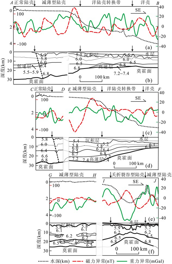

图 3 南海南、北陆缘水深、磁力和重力异常剖面
图中黑色箭头所示为推测的洋陆壳转折点; 图中黑线和黑色坐标值代表水深, 红线和红色坐标值代表磁异常, 绿线和绿色坐标值为自由空间重力异常; 在右下脚插图中从东到西依次为L1-L13
Fig. 3. Sections of water depth, gravity and magnetism anomalies in the conjugated margin of SCS
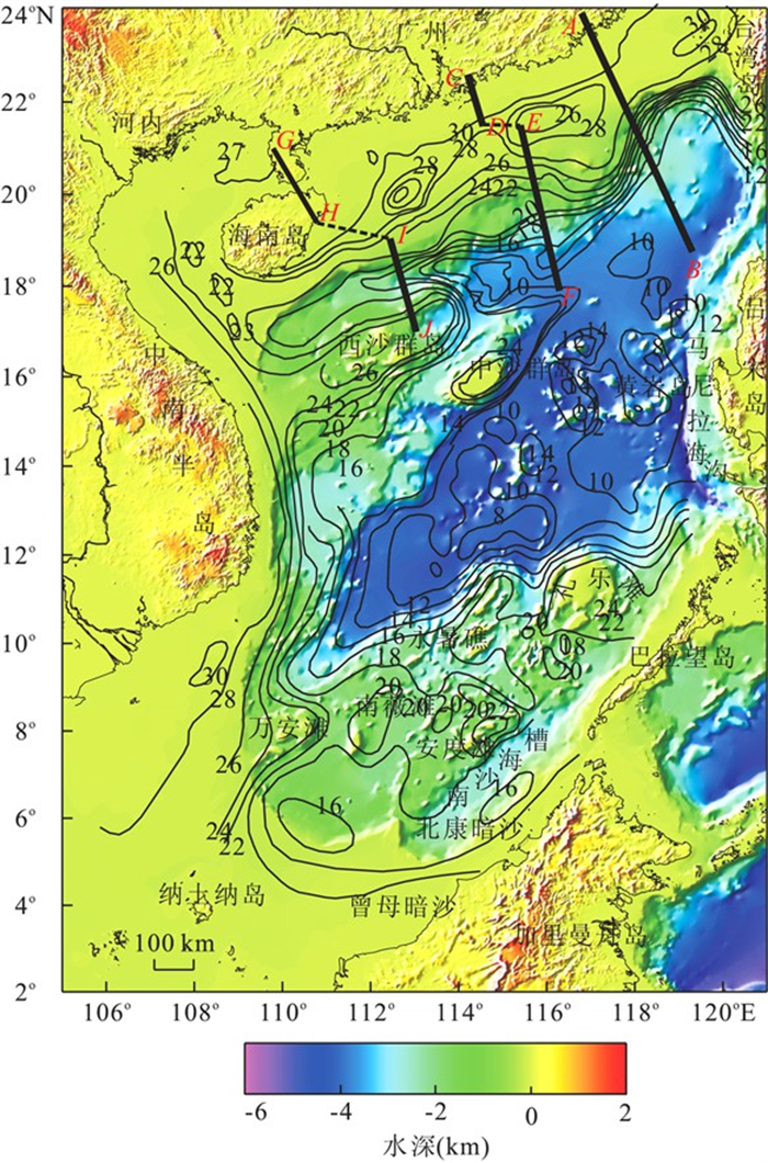
图 4 南海水深地形与莫霍面深度分布(莫霍面深度据苏达权等, 2004修改)
彩色为水深图; 等值线为莫霍面深度图(m)
Fig. 4. Distribution of water depth and moho in the SCS

图 5 南海自由空间重力异常与莫霍面深度分布(莫霍面深度据苏达权等, 2004修改)
彩色为重力异常图, 等值线为莫霍面深度(m)
Fig. 5. Distribution of gravity anomalies and Moho in the SCS
-
[1] Areshev, E. G., Tran, L. D., Ngo, T. S., et al., 1992. Reservoirs in fractured basement on the continental shelf of southern Vietnam. J. Petrol. Geol. , 15(4): 451-464. doi: 10.1111/j.1747-5457.1992.tb01045.x [2] Hazebroek, H. P., Tan, D. N. K., 1993. Tertiary tectonicevolution of the NW Sabah continental margin. In: The, G. H., ed., Proceedings of the symposium on tectonicframework and energy resources of the western marginof Pacific basin. Bull. Geol. Soc. Malaysia, 33: 195-210. doi: 10.7186/bgsm33199315 [3] Houtz, R. E., Hayes, D. E., 1984. Seismic reflection data from Sunda shelf. AAPG Bulletin, 68: 1870-1878. [4] Hutchison, C. S., 1996. The'Rajang accretionary prism' and' Lupar Line' problem of Borneo. In: Hall, R., Blundell, D., eds., Tectonic evolution of Southeast Asia. The Geological Society of London, Special Publications, 106: 247-262. doi: 10.1144/GSL.SP.1996.106.01.16 [5] Jia, S. X., Li, Z. X., Xu, Z. F., et al., 2006. Crustal structure features of the Leiqiong depression in Hainan Province. Chinese Journal of Geophysics, 49(5): 1385-1394 (in Chinese with English abstract). doi: 10.1002/cjg2.950/full [6] Jin, Q. H., 1989. Geology and hydrocarbon resources in the South China Sea. Geology Press, Beijing. [7] Liao, Q. L., Wang, Z. M., Wang, P. L., et al., 1988. Explosion seismic study of the crustal structure in FuzhouQuanzhou-Shantou region. Acta Geophysica Sinica, 31(3): 270-280 (in Chinese with English abstract). http://www.researchgate.net/publication/285838730 [8] Liu, H. L., Yang, S. K., Zhou, D., et al., 1998. Basic characteristics of extension structure in northern Nansha islands, China, and its dynamical implications. Geological Journal of China Universities, 4(1): 64-72 (in Chinese with English abstract). http://www.researchgate.net/publication/313659722_Basic_characteristics_of_extension_structure_in_northern_Nansha_islands_China_and_its_dynamical_implications [9] Nissen, S. S., Hayes, D. E., Buhl, P., et al., 1995. Deep penetrating seismic sounding across the northern margin of the South China Sea. Journal of Geophysical Research, 100(B11): 22407-22433. doi: 10.1029/95JB01866 [10] Qiu, X. L., Shi, X. B., Yan, P., et al., 2003. Recent progress of deep seismic experiments and studies of crustal structure in northern South China Sea. Progress in Natural Science, 13(7): 481-488. doi: 10.1080/10020070312331343890. [11] Qiu, X. L., Ye, S. Y., Wu, S. M., et al., 2001. Crustal structure across the Xisha trough, northwestern South China Sea. Tectonophysics, 341(1-4): 179-193. doi: 10.1016/S0040-1951(01)00222-0. [12] Ruan, A. G., Niu, X. W., Wu, Z. L., et al., 2009. The 2D velocity and density structure of the Mesozoic sediments in the Chaoshan depression. Geological Journal of China Universities, 15(4): 522-528 (in Chinese withEnglish abstract). http://www.researchgate.net/publication/308314983_The_2D_velocity_and_density_structure_of_the_Mesozoic_sediments_in_the_Chaoshan_depression [13] Su, D. Q., Liu, Z. H., Chen, X., et al., 1991. Features and interpretation of gravity in the Liyne bank and its surrounding areas. In: Nansha islands cruises of South China Sea institute of oceanology, ed., geology, geophysics and coral in the Nansha islands and its surrounding areas. Ocean Press, Beijing. [14] Su, D. Q., Liu, Y. Q., Chen, X., et al., 2004. Moho depth in South China Sea. In: Zhang, Z. J., Gao, R., Lv, Q. T., et al., eds., Deep structure and dynamics in the continent of China. Beijing, Science Press, 357-365. [15] Sun, Z., Sun, L. T., Zhou, D., et al., 2009. Discussion on the South China Sea evolution and lithospheric breakup through 3D analogue modeling. Earth Science—Journal of China University of Geoscineces, 34(3): 435-447 (in Chinese with English abstract). doi: 10.3799/dqkx.2009.049 [16] Taylor, B., Hayes, D. E., 1983. Origin and history of the South China Sea basin. In: Hayes, D. E., ed., The tectonic and geologic evolution of south eastern Asian Seas and Islands, II. Geophysical Monograph, AGU, Washington, D. C., 27, 23-56. [17] Tong, D. J., Ren, J. Y., Lei, C., et al., 2009. Lithosphere stretching model of deep water in Qiongdongnan basin, northern continental margin of South China Sea, and controlling of the post-rift subsidence. Earth Science—Journal of China University of Geoscineces, 34(6): 963-974 (in Chinese with English abstract). doi: 10.3799/dqkx.2009.110 [18] Wang, T. K., Chen, M. K., Lee, C. S., et al., 2006. Seismic imaging of the transitional crust across the northeastern margin of the South China Sea. Tectonophysics, 412(34): 237-254. doi: 10.1016/j.tecto.2005.10.039. [19] Wu, Z. L., Ruan, A. G., Li, J. B., et al., 2008. New progress of deep crust sounding in the mid-northern South China Sea using ocean bottom seismometers. South China Journal of Seismology, 28(1): 21-28 (in Chinese with English abstract). http://en.cnki.com.cn/Article_en/CJFDTOTAL-HNDI200801006.htm [20] Xia, K. Y., Huang, C. L., 1997. Tectonic framework and sedimentary basin analysis of the South China Sea and its surrounding areas. In: Gong, Z. S., Li, S. T., eds., Continental margin basin analysis and hydrocarbon accumulation of the northern South China Sea. Science Press, Beijing. [21] Xia, K. Y., Huang, C. L., 2000. The discovery of Meso-Tethys sedimentary basins in the South China Sea and their oil and gas perspective. Earth Science Frontiers, 7(3): 227-238 (in Chinese). http://www.researchgate.net/publication/285504858_The_discovery_of_Meso-Tethys_sedimentary_basins_in_the_South_China_Sea_and_their_oil_and_gas_perspective [22] Xia, S. H., Zhao, M. H., Qiu, X. L., et al., 2010. Crustal structure in an onshore-offshore transitional zone near Hong Kong, northern South China Sea. Journal of Asian Earth Sciences, 37(5-6): 460-472. doi: 10.1016/j.jseaes.2009.11.004. [23] Xu, H. L., Qiu, X. L., Zhao, M. H., et al., 2006. Characteristics of the crustal structure and hypocentral tectonics in the epicentral area of Nan'ao earthquake(M=7.5), the northeastern South China Sea. Chinese Science Bulletin, 51(Suppl. ): 95-106. doi: 10.1007/s11434-006-9095-x. [24] Yan, P., Zhou, D., Liu, Z. S., 2001. A crustal structure profile across the northern continental margin of the South China Sea. Tectonophysics, 338(1): 1-21. doi: 10.1016/S0040-1951(01)00062-2. [25] Yang, Z., Besse, J., 1993. Paleomagnetic study of Permian and Mesozoic sedimentary rocks from northern Thailand supports the extrusion model for Indochina. Earth and Planetary Science Letters, 117: 525-552. doi: 10.1016/0012-821X(93)90101-E. [26] Yao, B. C., Wan, L., Liu, Z. H., et al., 2004. Tectonic dynamics of Cenozoic sedimentary basins and hydrocarbon resources in the South China Sea. Earth Science—Journal of China University of Geoscineces, 29(5): 543-549 (in Chinese with English abstract). http://www.researchgate.net/publication/279756612_Tectonic_dynamics_of_Cenozoic_sedimentary_basins_and_hydrocarbon_resources_in_the_South_China_Sea [27] Yao, B. C., Zeng, W. J., Hayes, D. E., et al., 1994. The geological memoir of South China Sea survey jointly by China and USA. China University of Geosciences Press, Beijing (in Chinese). [28] Yin, Z. X., Lai, M. H., Xiong, S. B., et al., 1999. Crustal structure and velocity distribution from deep seismic sounding along the profile Lianxian-Boluo-Gankou in South China. Chinese Journal of Geophysics, 42(3): 383-392 (in Chinese with English abstract). http://en.cnki.com.cn/Article_en/CJFDTotal-DQWX199903010.htm [29] Zhang, Y., Deng, C. M., Zhao, Y., 1991. Features and geological implications of magnetic anomalies in the Liyne Bank. In: Nansha islands cruises of South China Sea institute of oceanology, ed., geology, geophysics and coral in the Nansha islands and its surrounding areas. Ocean Press, Beijing. [30] Zhao, M. H., Qiu, X. L., Xia, S. H., et al., 2010. Seismic structure in the northeastern South China Sea: S-wave velocity and Vp/Vs ratios derived from three-component OBS data. Tectonophysics, 480(1-4): 183-197. doi: 10.1016/j.tecto.2009.10.004. [31] Zhao, M. H., Qiu, X. L., Ye, C. M., et al., 2004. Analysis on deep crustal structure along the onshore-offshore seismic profile across the Binhai (littoral) fault zone in northeastern South China Sea. Chinese Journal of Geophysics, 47(5): 845-852 (in Chinese with English abstract). http://www.researchgate.net/profile/Ping_Wang45/publication/260409872_An_Analysis_on_Deep_Crustal_Structure_Along_the_Onshore-Offshore_Seismic_Profile_Across_the_Binghai_(Littoral)_Fault_Zone_in_Ne_South_China_Sea/links/562ec79a08aef25a24445367.pdf [32] Zhou, D., Ru, K., Chen, H. Z., 1995. Kinematics of Cenozoic extension on the South China Sea continental margin and its implications for the tectonic evolution of the region. Tectonophysics, 251(1-4): 161-177. doi: 10.1016/0040-1951(95)00018-6. [33] 嘉世旭, 李志雄, 徐朝繁, 等, 2006. 雷琼拗陷地壳结构特征. 地球物理学报, 49(5): 1385-1394. doi: 10.3321/j.issn:0001-5733.2006.05.018 [34] 金庆焕, 1989. 南海地质与油气资源. 北京: 地质出版社. [35] 廖其林, 王振明, 王屏路, 等, 1988. 福州—泉州—汕头地区地壳结构的爆炸地震研究. 地球物理学报, 31(3): 270-280. doi: 10.3321/j.issn:0001-5733.1988.03.004 [36] 刘海龄, 杨树康, 周蒂, 等, 1998. 南沙北部伸展构造的基本特征及其动力学意义. 高校地质学报, 4(1): 64-72. https://www.cnki.com.cn/Article/CJFDTOTAL-GXDX801.007.htm [37] 丘学林, 施小斌, 阎贫, 等, 2003. 南海北部地壳结构的深地震探测和研究新进展. 自然科学进展, 13(3): 231-236. doi: 10.3321/j.issn:1002-008X.2003.03.002 [38] 阮爱国, 牛雄伟, 吴振利, 等, 2009. 潮汕坳陷中生代沉积的折射波2D速度结构和密度. 高校地质学报, 15(4): 522-528. doi: 10.3969/j.issn.1006-7493.2009.04.011 [39] 苏达权, 刘云龙, 陈雪, 等, 2004. 南海的三维莫霍界面. 见: 张忠杰, 高锐, 吕庆田, 等, 编. 中国大陆地球深部结构与动力学研究. 北京: 科学出版社, 357-365. [40] 苏达权, 刘祖惠, 陈雪, 等, 1991. 礼乐滩及其邻近海区的重力场特征及解释. 见: 中国科学院南沙综合科学考察队, 编, 南沙群岛及其邻近海区地质地球物理及岛礁研究论文集(一), 北京: 海洋出版社. [41] 孙珍, 孙龙涛, 周蒂, 等, 2009. 南海岩石圈破裂方式与扩张过程的三维物理模拟. 地球科学——中国地质大学学报, 34(3): 435-447. https://www.cnki.com.cn/Article/CJFDTOTAL-DQKX200903008.htm [42] 佟殿君, 任建业, 雷超, 等, 2009. 琼东南盆地深水区岩石圈伸展模式及其对裂后期沉降的控制. 地球科学——中国地质大学学报, 34(6): 963-974. https://www.cnki.com.cn/Article/CJFDTOTAL-DQKX200906012.htm [43] 吴振利, 阮爱国, 李家彪, 等, 2008. 南海中北部地壳深部结构探测新进展. 华南地震, 28(1): 21-28. https://www.cnki.com.cn/Article/CJFDTOTAL-HNDI200801006.htm [44] 夏戡原, 黄慈流, 1997. 南海及围区大地构造格架与沉积盆地分布. 见: 龚再升, 李思田, 等编著, 南海北部大陆边缘盆地分析与油气聚集. 北京: 科学出版社. [45] 夏戡原, 黄慈流, 2000. 南海中生代特提斯期沉积盆地的发现与找寻中生代含油气盆地的前景. 地学前缘, 7(3): 227-238. https://www.cnki.com.cn/Article/CJFDTOTAL-DXQY200003028.htm [46] 徐辉龙, 丘学林, 赵明辉, 等, 2006. 南海东北部南澳大地震(M=7.5)震中区的地壳结构特征与震源构造. 科学通报, 51(增刊2): 83-91. https://www.cnki.com.cn/Article/CJFDTOTAL-KXTB2006S3015.htm [47] 姚伯初, 万玲, 刘振湖, 等, 2004. 南海海域新生代沉积盆地构造演化的动力学特征及其油气资源. 地球科学——中国地质大学学报, 29(5): 543-549. https://www.cnki.com.cn/Article/CJFDTOTAL-DQKX200405006.htm [48] 姚伯初, 曾维军, Hayes, D. E., 等, 1994. 中美合作调研南海地质专报. 北京: 中国地质大学出版社. [49] 尹周勋, 赖明惠, 熊绍柏, 等, 1999. 华南连县—博罗—港口地带地壳结构及速度分布的爆炸地震探测结果. 地球物理学报, 42(3): 383-392. doi: 10.3321/j.issn:0001-5733.1999.03.011 [50] 张毅祥, 邓传明, 赵岩, 1991. 礼乐滩磁异常特征及其地质意义. 见: 中国科学院南沙综合科学考察队, 编, 南沙群岛及其邻近海区地质地球物理及岛礁研究论文集(一). 北京: 海洋出版社. [51] 赵明辉, 丘学林, 叶春明, 等, 2004. 南海东北部海陆深地震联测与滨海断裂带两侧地壳结构分析. 地球物理学报, 47(5): 845-852. doi: 10.3321/j.issn:0001-5733.2004.05.016 -

 下载:
下载:
 点击查看大图
计量
- 文章访问数: 4303
- HTML全文浏览量: 901
- PDF下载量: 98
- 被引次数: 0
