


Earthquake Triggered Landslide Susceptibility Evaluation Based on GIS Platform and Weight-of-Evidence Modeling
-
摘要: 汶川地震诱发了数以万计的滑坡灾害.应用地理信息系统与遥感技术, 选取地震烈度、岩性、坡度、断层、高程、坡向、河流与公路8个因素作为汶川地震滑坡影响因子, 采用证据权方法, 对研究区内汶川地震滑坡进行灾害易发性研究.检验表明, 易发性评价结果的正确率达到81.855%.不同因子组合评价结果表明, 地震烈度对滑坡易发性分区结果影响最大, 而地质、地形、人类活动因素对地震滑坡影响相对较小.使用自然分类法则方法将研究区内滑坡按易发程度分为极高易发区、高易发区、中易发区、低易发区与极低易发区5类, 极高易发区与高易发区面积之和约为11255.93km2, 占研究区总面积的23.12%, 其中发育滑坡面积为521.98km2, 占滑坡总面积的73.36%.Abstract: Wenchuan earthquake triggered tens of thousands of landslides. Eight factors that influence landslide occurrence, including seismic intensity, lithology, slope angle, faults, elevation, slope aspect, drainages, and roads were created in raster data format base on geographical information system (GIS) and remote sensing (RS) technologies. The landslide hazard map was derived by using weight-of-evidence modeling. Earthquake-induced landslide susceptibility zonings of other eight impact factor combination categories were analyzed and mapped one after another, using GIS raster analysis methods. The eight different impact factor combinations analysis suggests that seismic intensity play an important role in determining the landslide susceptibility index value, while geological, geomorphological, and human-related factors only play minor roles. The resulting susceptibility map was divided into five categories, i.e. extremely high, high, moderate, low, and extremely low by using Natural Breaks law. The validation results show satisfactory agreement between the susceptibility map and the existing data on landslide distributions in the form of area under curve (AUC) up to 81.855%. The area with extremely high and high susceptibility accounts for about 11255.93km2, 23.12% of the study area, including landslide areas of 521.98km2, 73.36% of all landslide occurrence areas.
-
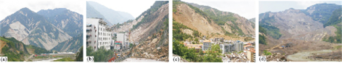
图 1 汶川地震诱发不同类型滑坡典型照片
a.密集发育的滑坡群;b.北川新中崩塌;c.北川老城王家岩滑坡;d.青川东河口高速远程碎屑流
Fig. 1. Different types of landslides triggered by the Wenchuan earthquake
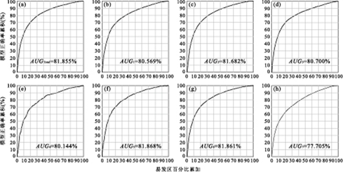
图 3 8种滑坡影响因子组合下的易发性评价成功率检验曲线
Fig. 3. Success rate curves of landslide susceptibility values calculated from 8 impact factor combinations
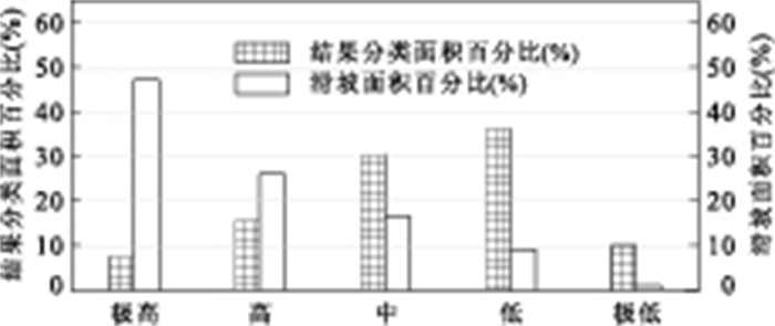
图 4 滑坡易发性统计分析结果
Fig. 4. Statistics analysis result of earthquake-induced landslide susceptibility
表 1 基于汶川地震滑坡的8个影响因子各个等级证据权计算
Table 1. Computed weight-of-evidence for classes of various data layers based on Wenchuan earthquake-induced landslides
影响因子及分级 栅格数 栅格数(%) 滑坡栅格数 滑坡栅格数(%) 比率 W+ W- Wf 地震烈度 1:Ⅵ 979925 0.8052 158 0.0089 0.011 -4.5217 0.0081 -4.5298 2:Ⅶ 33747147 27.7308 149764 8.4188 0.3036 -1.2024 0.2408 -1.4432 3:Ⅷ 54272356 44.5968 324309 18.2307 0.4088 -0.9033 0.3964 -1.2996 4:Ⅸ 18768949 15.4229 334017 18.7764 1.2174 0.2 -0.041 0.241 5:Ⅹ 8234811 6.7667 536805 30.1759 4.4594 1.5477 -0.2928 1.8406 6:Ⅺ 5692379 4.6776 433867 24.3893 5.2141 1.7159 -0.2347 1.9507 岩性 1:Ⅰ类 6180804 5.0789 14759 0.8297 0.1634 -1.8242 0.0445 -1.8686 2:Ⅱ类 8280948 6.8046 42522 2.3903 0.3513 -1.0558 0.047 -1.1027 3:Ⅲ类 4982141 4.0939 47192 2.6528 0.648 -0.4391 0.0151 -0.4542 4:Ⅳ类 12176668 10.0058 300024 16.8655 1.6856 0.5323 -0.0804 0.6127 5:Ⅴ类 75896394 62.3658 864346 48.5882 0.7791 -0.2529 0.3174 -0.5703 6:Ⅵ类 4957067 4.0733 22084 1.2414 0.3048 -1.1985 0.0295 -1.228 7:Ⅶ类 9221551 7.5776 487993 27.432 3.6202 1.3262 -0.245 1.5712 坡度 1:<10° 12787708 10.5079 38877 2.1854 0.208 -1.582 0.0903 -1.6723 2:10°~20° 12843642 10.5539 90244 5.073 0.4807 -0.7402 0.0604 -0.8006 3:20°~30° 28754523 23.6282 261487 14.6992 0.6221 -0.4802 0.1123 -0.5925 4:30°~40° 38904975 31.9691 555194 31.2096 0.9762 -0.0244 0.0113 -0.0357 5:40°~50° 22361909 18.3753 557180 31.3213 1.7045 0.5438 -0.175 0.7188 6:50°~60° 5306897 4.3608 226672 12.7421 2.922 1.1012 -0.093 1.1942 7:>60° 735913 0.6047 49266 2.7694 4.5797 1.5762 -0.0223 1.5985 距离断裂 1:F1:0~500m 688074 0.565 13043 0.7332 1.2968 0.2643 -0.0017 0.266 2:F1:500~1000m 729475 0.5994 9953 0.5595 0.9334 -0.0699 0.0004 -0.0703 3:F1:1000~1500m 744900 0.6121 9449 0.5312 0.8678 -0.1438 0.0008 -0.1446 4:F1:1500~2000m 754383 0.6199 11191 0.6291 1.0148 0.0149 -0.0001 0.015 5:F1:2000~3000m 1500274 1.2328 24014 1.3499 1.095 0.0922 -0.0012 0.0934 6:F1:3000~4000m 1416755 1.1642 17210 0.9674 0.831 -0.1876 0.002 -0.1896 7:F2:0~500m 852199 0.7003 60812 3.418 4.8817 1.6448 -0.0282 1.673 8:F2:500~1000m 869094 0.7142 59611 3.351 4.6922 1.6022 -0.0273 1.6295 9:F2:1000~1500m 864559 0.7104 54352 3.0553 4.3007 1.509 -0.0243 1.5332 10:F2:1500~2000m 861783 0.7081 48112 2.7046 3.8192 1.3828 -0.0206 1.4034 11:F2:2000~3000m 1706741 1.4025 99394 5.5873 3.9839 1.4275 -0.044 1.4715 12:F2:3000~4000m 1656973 1.3616 86001 4.8345 3.5506 1.3057 -0.0364 1.3421 13:F3:0~500m 803491 0.6602 12786 0.7188 1.0886 0.0862 -0.0006 0.0868 14:F3:500~1000m 821666 0.6752 15426 0.8672 1.2843 0.2545 -0.002 0.2564 15:F3:1000~1500m 827863 0.6803 22523 1.2661 1.8612 0.6341 -0.006 0.6401 16:F3:1500~2000m 834363 0.6856 23191 1.3037 1.9014 0.6561 -0.0063 0.6624 17:F3:2000~3000m 1690111 1.3888 39192 2.2031 1.5864 0.4702 -0.0084 0.4786 18:F3:3000~4000m 1710914 1.4059 43339 2.4363 1.7329 0.5607 -0.0107 0.5714 19:缓冲区外 102361955 84.1131 1129321 63.4835 0.7547 -0.285 0.8517 -1.1367 高程 1:<1000m 19799704 16.2699 182347 10.2504 0.63 -0.4675 0.0705 -0.538 2:1000~1500m 22965976 18.8717 565039 31.763 1.6831 0.5308 -0.1754 0.7062 3:1500~2000m 24682865 20.2825 405527 22.7962 1.1239 0.1187 -0.0325 0.1512 4:2000~2500m 17161003 14.1016 246511 13.8573 0.9827 -0.0177 0.0029 -0.0206 5:2500~3000m 12901928 10.6018 151924 8.5402 0.8055 -0.2191 0.0231 -0.2423 6:3000~3500m 9882054 8.1203 98787 5.5532 0.6839 -0.3847 0.028 -0.4126 7:3500~4000m 7228803 5.9401 84420 4.7456 0.7989 -0.2275 0.0128 -0.2403 8:4000~4500m 4825053 3.9649 32379 1.8201 0.4591 -0.7865 0.0224 -0.809 9:4500~5000m 1986444 1.6323 11807 0.6637 0.4066 -0.9087 0.0099 -0.9186 高程 10:5000~5500m 251341 0.2065 179 0.0101 0.0487 -3.0357 0.002 -3.0377 11:>5500m 10396 0.0085 Nan Nan 0 -5.0383 0.0001 -5.0384 坡向 1:平坦 3030811 2.4905 9354 0.5258 0.2111 -1.5669 0.0202 -1.5871 2:北 13379293 10.9941 184407 10.3662 0.9429 -0.0596 0.0071 -0.0668 3:北东 14250052 11.7096 211530 11.8909 1.0155 0.0156 -0.0021 0.0177 4:东 16452226 13.5192 283102 15.9143 1.1772 0.1657 -0.0285 0.1942 5:南东 17322933 14.2346 304389 17.1109 1.2021 0.187 -0.0346 0.2216 6:南 15208207 12.4969 236407 13.2894 1.0634 0.0624 -0.0092 0.0717 7:南西 14126254 11.6079 185236 10.4128 0.8971 -0.1102 0.0136 -0.1238 8:西 13804928 11.3438 177945 10.003 0.8818 -0.1275 0.0152 -0.1428 9:北西 14120863 11.6034 186550 10.4867 0.9038 -0.1026 0.0127 -0.1154 距离水系 1:0~200m 30784000 25.2959 544210 30.5922 1.2094 0.193212 -0.0746 0.2678 2:200~400m 26700900 21.9407 458778 25.7897 1.1754 0.164236 -0.0513 0.2155 3:400~600m 20785063 17.0796 310642 17.4624 1.0224 0.0225 -0.0047 0.0272 4:600~800m 15768157 12.9571 200357 11.2628 0.8692 -0.14207 0.0196 -0.1616 5:800~1000m 10323135 8.4828 111587 6.2727 0.7395 -0.30568 0.0242 -0.3299 6:>1000m 17334312 14.244 153346 8.6202 0.6052 -0.50807 0.0645 -0.5726 距离公路 1:0~1000m 9203286 7.5625 277079 15.5757 2.0596 0.7383 -0.092 0.8303 2:1000~2000m 8361515 6.8708 165543 9.3058 1.3544 0.3086 -0.0269 0.3355 3:2000~3000m 7852565 6.4526 125367 7.0474 1.0922 0.0895 -0.0065 0.096 4:3000~4000m 7454298 6.1254 105367 5.9231 0.967 -0.0341 0.0022 -0.0363 5:4000~5000 m 7026799 5.7741 86084 4.8391 0.8381 -0.179 0.01 -0.1891 6:>5000m 81797110 67.2145 1019480 57.3089 0.8526 -0.1616 0.2685 -0.4301  下载: 导出CSV
表 2 不同滑坡易发性评价因子组合及AUC检验结果
Table 2. Different impact factor combinations for landslide susceptibility evaluation and AUC results
组合 因子列表 AUC(%) 全选 烈度、岩性、坡度、断层、高程、坡向、河流、公路 81.855 组合1 烈度、坡度、坡向、高程、水系 80.569 组合2 烈度、坡度、坡向、高程、水系、岩性、断裂 81.682 组合3 烈度、坡度、坡向、高程、水系、公路 80.700 组合4 烈度、岩性、断裂、公路 80.144 组合5 烈度、岩性、坡度、公路 81.868 组合6 烈度、坡度、坡向、岩性、断裂、公路 81.861 组合7 岩性、坡度、断层、高程、坡向、河流、公路 77.705
下载: 导出CSV
表 3 滑坡易发性统计
Table 3. Susceptibility to landsliding
评价结果 预测(km2) 百分比(%) 实滑(km2) 百分比(%) 面密度(%) 极高易发区 3617.39 7.43 336.11 47.24 9.29 高易发区 7638.54 15.69 185.87 26.12 2.43 中易发区 14848.30 30.50 117.66 16.53 0.79 低易发区 17653.69 36.27 65.44 9.20 0.37 极低易发区 4920.29 10.11 6.48 0.91 0.13
下载: 导出CSV
-
Agterberg, F.P., 1992. Combining indicator patterns in weights of evidence modeling for resource evaluation. Natural Resources Research, 1(1): 39-50. doi: 10.1007/BF01782111 Bonham-Carter, G.F., Agterberg, F.P., Wright, D.F., 1989. Weights of evidence modelling: a new approach to mapping mineral potential. Statistical Applications in the Earth Science, Geological Survey of Canada Paper 89-9, 171-183. Chang, D.S., Zhang, L.M., Xu, Y., et al., 2009. Analysis of overtopping failure of Hongshihe landslide dam after Wenchuan earthquake. Journal of Engineering Geology, 17(1): 50-55 (in Chinese with English abstract). http://www.researchgate.net/publication/278021037_Analysis_of_overtopping_failure_of_Hongshihe_landslide_dam_after_Wenchuan_earthquake Cheng, Q., 2004. Application of weights of evidence method for assessment of flowing wells in the Greater Toronto area, Canada. Natural Resource Research, 13(2), 77-86. doi: 10.1023/B:NARR.0000032645.46747.48 Conoscenti, C., Di Maggio, C., Rotiglinao, E., 2008. GIS analysis to assess landslide susceptibility in a fluvial basin of NW Sicily (Italy). Geomorphology, 94(3-4): 325-339. doi: 10.1016/j.geomorph.2006.10.039 Cui, P., Chen, X.Q., Zhu, Y.Y., et al., 2011. The Wenchuan earthquake (May 12, 2008), Sichuan Province, China, and resulting geohazards. Natural Hazards, 56(1): 19-36. doi: 10.1007/s11069-009-9392-1 Dahal, R.K., Hasegawa, S., Nonomura, A., et al., 2008a. GIS-based weights-of-evidence modelling of rainfall-induced landslides in small catchments for landslide susceptibility mapping. Environmental Geology, 54(2): 311-324. doi: 10.1016/j.geomorph.2008.05.041 Dahal, R.K., Hasegawa, S., Nonomura, A., et al., 2008b. Predictive modelling of rainfall-induced landslide hazard in the Lesser Himalaya of Nepal based on weights-of-evidence. Geomorphology, 102(3-4): 496-510. doi: 10.1007/s00254-007-0818-3 Daneshfar, B., Benn, K., 2002. Spatial relationships between natural seismicity and faults, southeastern Ontario and north-central New York state. Tectonophysics, 353(1-4): 31-44. doi: 10.1016/S0040-1951(02)00279-2 Huang, R.Q., Li, W.L., 2008. Research on development and distribution rules of geohazards induced by Wenchuan earthquake on 12th May, 2008. Chinese Journal of Rock Mechanics and Engineering, 27(12): 2585-2592 (in Chinese with English abstract). http://www.oalib.com/paper/1485382 Huang, R.Q., Li, W.L., 2009. Fault effect analysis of geo-hazard triggered by Wenchuan earthquake. Journal of Engineering Geology, 17(1): 19-28 (in Chinese with English abstract). http://www.researchgate.net/publication/284061455_Fault_effect_analysis_of_geo-hazard_triggered_by_Wenchuan_earthquake Kamp, U., Growley, B.J., Khattak, G.A., et al., 2008. GIS-based landslide susceptibility mapping for the 2005 Kashmir earthquake region. Geomorphology, 101(4): 631-642. doi: 10.1016/j.geomorph.2008.03.003 Lee, S., Choi, J., 2004. Landslide susceptibility mapping using GIS and the weight-of-evidence model. International Journal of Geographical Information Science, 18(8): 789-814. doi: 10.1080/13658810410001702003 Neuhauser, B., Terhorst, B., 2007. Landslide susceptibility assessment using "weights-of-evidence" applied to a study area at the Jurassic escarpment (SW-Germany). Geomorphology, 86(1-2): 12-24. doi: 10.1016/j.geomorph.2006.08.002 Qi, S.W., Xu, Q., Liu, C.L., et al., 2009. Slope instabilities in the severest disaster areas of "5·12" Wenchuan earthquake. Journal of Engineering Geology, 17(1): 39-49 (in Chinese with English abstract). http://en.cnki.com.cn/Article_en/CJFDTOTAL-GCDZ200901006.htm Sato, H.P., Harp, E.L., 2009. Interpretation of earthquake-induced landslides triggered by the 12 May 2008, M7.9 Wenchuan earthquake in the Beichuan area, Sichuan Province, China using satellite imagery and Google Earth. Landslides, 6(2): 153-159. doi: 10.1007/s10346-009-0147-6 Sharma, M., Kumar, R., 2008. GIS-based landslide hazard zonation: a case study from the Parwanoo area, Lesser and Outer Himalaya, H.P., India. Bulletin of Engineering Geology and the Environment, 67(1): 129-137. doi: 10.1007/s10064-007-0113-2 Song, R.H., Hiromu, D., Kazutoki, A., et al., 2008. Modeling the potential distribution of shallow-seated landslides using the weights of evidence method and a logistic regression model: a case study of the Sabae Area, Japan. International Journal of Sediment Research, 23(2): 106-118. doi: 10.1016/S1001-6279(08)60010-4 Su, F.H., Liu, H.J., Han, Y.S., 2008. The extraction of mountain hazard induced by Wenchuan earthquake and analysis of its distributing characteristic. Journal of Remote Sensing, 12(6): 956-963 (in Chinese with English abstract). http://www.cqvip.com/QK/92457A/200806/1000948015.html Wang, F.W., Cheng, Q.G., Highland, L., et al., 2009. Preliminary investigation of some large landslides triggered by the 2008 Wenchuan earthquake, Sichuan Province, China. Landslides, 6(1): 47-54. doi: 10.1007/s10346-009-0141-z Wang, Z.W., Li, R.Y., Wang, X.G., 2007. Zonation of landslide hazards based on weights of evidence model. Chinese Journal of Geotechnical Engineering, 29(8): 1268-1273 (in Chinese with English abstract). http://www.cnki.com.cn/Article/CJFDTotal-YTGC200708028.htm Wu, S.R., Shi, J.S., Yao, X., et al., 2008. Analysis and evaluation of geohazard intensity of the Wenchuan earthquake, Sichuan, China. Geological Bulletin of China, 27(11): 1900-1906 (in Chinese with English abstract). http://www.zhangqiaokeyan.com/academic-journal-cn_geological-bulletin-china_thesis/0201252288013.html Xie, H., Wang, S.G., Kong, J.M., 2008. Distribution and characteristics of mountain hazards induced by the earthquake of May 12 in Wenchuan, China. Journal of Mountain Science, 26(4): 396-401 (in Chinese with English abstract). http://en.cnki.com.cn/Article_en/CJFDTOTAL-YSLX200812032.htm Xu, C., Dai, F.C., Yao, X., 2009a. Incidence number and affected area of Wenchuan earthquake-induced landslides. Science & Technology Review, 27(11): 79-81 (in Chinese with English abstract). http://www.researchgate.net/publication/284027000_Incidence_number_and_affected_area_of_Wenchuan_earthquake-induced_landslides/download Xu, C., Dai, F.C., Yao, X., et al., 2009b. GIS-based landslide susceptibility assessment using analytical hierarchy process (AHP) for May 12, 2008 Wenchuan earthquake region. Chinese Journal of Rock Mechanics and Engineering, 28(S2): 3978-3985 (in Chinese with English abstract). http://www.researchgate.net/publication/285982123_GIS-based_landslide_susceptibility_assessment_using_analytical_hierarchy_process_in_wenchuan_earthquake_region Xu, C., Dai, F.C., Chen, J., et al., 2009c. Identification and analysis of secondary geological hazards triggered by a magnitude 8.0 Wenchuan earthquake. Journal of Remote Sensing, 13(4): 745-753. (in Chinese with English abstract). Xu, C., Dai, F.C., Yao, X., et al., 2010a. GIS based certainty factor analysis of landslide triggering factors in Wenchuan earthquake of 12 May 2008, Sichuan, China. Chinese Journal of Rock Mechanics and Engineering, 29(S1): 1-9 (in Chinese with English abstract). Xu, C., Dai, F.C., Yao, X., 2010b. Study on Wenchuan earthquake-induced landslide susceptibility evaluation based on GIS platform and certainty factor analysis method. Journal of Engineering Geology, 18(1): 15-26 (in Chinese with English abstract). Xu, C., Dai, F.C., Tu, X.B., et al., 2010c. Statistical analysis of the characteristic parameters of landslides triggered by the May 12, 2008 Wenchuan earthquake. Journal of Natural Disasters, 19(2): 1-8 (in Chinese with English abstract). Xu, Q., Huang, R.Q., 2008. Kinetics characteristics of large landslides triggered by May 12th Wenchuan earthquake. Journal of Engineering Geology, 16(6): 721-729 (in Chinese with English abstract). http://www.researchgate.net/publication/312851560_Kinetics_characteristics_of_large_landslides_triggered_by_May_12th_Wenchuan_earthquake Yao, X., Xu, C., Dai, F.C., et al., 2009. Contribution of strata lithology and slope gradient to landslides triggered by Wenchuan Ms 8 earthquake, Sichuan, China. Geological Bulletin of China, 28(8): 1156-1162 (in Chinese with English abstract). http://d.wanfangdata.com.cn/periodical/zgqydz200908019 Yin, Y.P., 2008. Research on the geo-hazards triggered by Wenchuan earthquake, Sichuan. Journal of Engineering Geology, 16(4): 7-12 (in Chinese with English abstract). http://www.cqvip.com/QK/98122X/20084/28046458.html Yin, Y.P., 2009. Features of landslides triggered by the Wenchuan earthquake. Journal of Engineering Geology, 17(1): 29-38 (in Chinese with English abstract). http://en.cnki.com.cn/Article_en/CJFDTOTAL-GCDZ200901005.htm Yin, Y.P., Wang, F.W., Sun, P., 2009. Landslide hazards triggered by the 2008 Wenchuan earthquake, Sichuan, China. Landslides, 6(2): 139-152. doi: 10.1007/s10346-009-0148-5 Zahiri, H., Palamara, D.R., Flentje, P., et al., 2006. A GIS-based weights-of-evidence model for mapping cliff instabilities associated with mine subsidence. Environmental Geology, 51(3): 377-386. doi: 10.1007/s00254-006-0333-y Zhang, Y.S., Lei, W.Z., Shi, J.S., et al., 2008. General characteristics of "5·12" earthquake-induced geohazards in Sichuan. Journal of Geomechanics, 14(2): 109-116 (in Chinese with English abstract). http://www.cnki.com.cn/Article/CJFDTotal-DZLX200802002.htm Zezere, J.L., Garcia, R.A.C., Oliveira, S.C., et al., 2008. Probabilistic landslide risk analysis considering direct costs in the area north of Lisbon (Portugal). Geomorphology, 94(3-4): 467-495. doi: 10.1016/j.geomorph.2006.10.040 常东升, 张利民, 徐耀, 等, 2009. 红石河堰塞湖漫顶溃坝风险评估. 工程地质学报, 17(1): 50-55. doi: 10.3969/j.issn.1004-9665.2009.01.006 黄润秋, 李为乐, 2008. "5·12"汶川大地震触发地质灾害的发育分布规律研究. 岩石力学与工程学报, 27(12): 2585-2592. doi: 10.3321/j.issn:1000-6915.2008.12.028 黄润秋, 李为乐, 2009. 汶川大地震触发地质灾害的断层效应分析. 工程地质学报, 17(1): 19-28. doi: 10.3969/j.issn.1004-9665.2009.01.003 祁生文, 许强, 刘春玲, 等, 2009. 汶川地震极重灾区地质背景及次生斜坡灾害空间发育规律. 工程地质学报, 17(1): 39-49. doi: 10.3969/j.issn.1004-9665.2009.01.005 苏凤环, 刘洪江, 韩用顺, 2008. 汶川地震山地灾害遥感快速提取及其分布特点分析. 遥感学报, 12(6): 956-963. https://www.cnki.com.cn/Article/CJFDTOTAL-YGXB200806018.htm 王志旺, 李端有, 王湘桂, 2007. 证据权法在滑坡危险度区划研究中的应用. 岩土工程学报, 29(8): 1268-1273. doi: 10.3321/j.issn:1000-4548.2007.08.026 吴树仁, 石菊松, 姚鑫, 等, 2008. 四川汶川地震地质灾害活动强度分析评价. 地质通报, 27(11): 1900-1906. doi: 10.3969/j.issn.1671-2552.2008.11.020 谢洪, 王士革, 孔纪名, 2008. "5·12"汶川地震次生山地灾害的分布与特点. 山地学报, 26(4): 396-401. https://www.cnki.com.cn/Article/CJFDTOTAL-SDYA200804005.htm 许冲, 戴福初, 姚鑫, 2009a. 汶川地震诱发滑坡灾害的数量与面积. 科技导报, 27(11): 79-81. https://www.cnki.com.cn/Article/CJFDTOTAL-KJDB200911035.htm 许冲, 戴福初, 姚鑫, 等, 2009b. GIS支持下基于层次分析法的汶川地震区滑坡易发性评价. 岩石力学与工程学报, 28(S2): 3978-3985. https://www.cnki.com.cn/Article/CJFDTOTAL-YSLX2009S2104.htm 许冲, 戴福初, 陈剑, 等, 2009c. 汶川Ms8.0地震重灾区次生地质灾害遥感精细解译. 遥感学报, 13(4), 754-762. https://www.cnki.com.cn/Article/CJFDTOTAL-YGXB200904031.htm 许冲, 戴福初, 姚鑫, 等, 2010a. 基于GIS的汶川地震滑坡灾害影响因子确定性系数分析. 岩石力学与工程学报, 29(S1): 1-9. https://www.cnki.com.cn/Article/CJFDTOTAL-YSLX2010S1057.htm 许冲, 戴福初, 姚鑫, 2010b. 基于GIS与确定性系数分析方法的汶川地震滑坡易发性评价. 工程地质学报, 18(1): 15-26. https://www.cnki.com.cn/Article/CJFDTOTAL-GCDZ201001003.htm 许冲, 戴福初, 涂新斌, 等, 2010c. "5·12"汶川地震诱发滑坡特征参数统计分析. 自然灾害学报, 19(4): 1-8. https://www.cnki.com.cn/Article/CJFDTOTAL-ZRZH201104023.htm 许强, 黄润秋, 2008. "5·12"汶川大地震诱发大型崩滑灾害动力特征初探. 工程地质学报, 16(6): 721-729. doi: 10.3969/j.issn.1004-9665.2008.06.001 姚鑫, 许冲, 戴福初, 等, 2009. 四川汶川Ms 8级地震引发的滑坡与地层岩性、坡度的相关性. 地质通报, 28(8): 1156-1162. doi: 10.3969/j.issn.1671-2552.2009.08.019 殷跃平, 2008. 汶川八级地震地质灾害研究. 工程地质学报, 16(4): 7-12. https://www.cnki.com.cn/Article/CJFDTOTAL-GCDZ200804000.htm 殷跃平, 2009. 汶川八级地震滑坡特征分析. 工程地质学报, 17(1): 29-38. doi: 10.3969/j.issn.1004-9665.2009.01.004 张永双, 雷伟志, 石菊松, 等, 2008. 四川"5·12"地震次生地质灾害的基本特征初析. 地质力学学报, 14(2): 109-116. doi: 10.3969/j.issn.1006-6616.2008.02.002 -


 点击查看大图
计量
- 文章访问数: 695
- HTML全文浏览量: 1028
- PDF下载量: 23
- 被引次数: 0
