


Correction of OBS Position and Recent Advances of 3D Seismic Exploration in the Central Sub-Basin of South China Sea
-
摘要: 南海中央次海盆首次开展的三维海底地震仪(ocean bottom seismometer, OBS)探测试验, 对于全面认识南海扩张脊处速度展布特征及海底扩张历史有着重要意义.海底地震仪的位置是研究三维地震结构的关键参数之一, 高精度的三维OBS数据处理, 决定着后期地震结构反演模型的分辨率与准确性.利用直达水波走时信息, 综合最小二乘法反演原理, 并采用蒙特卡罗法模拟OBS降落海底的过程, 完成了南海中央次海盆试验区39台OBS数据格式转换与位置校正工作; 同时探讨了蒙特卡罗法应用于位置校正的精度问题.处理后OBS综合记录剖面中展示了多组清晰可靠、来自珍贝-黄岩火山链下深部结构中的P波震相, 如Pg、PmP和Pn震相, 为下一步南海中央次海盆的三维层析成像奠定了坚实数据基础.Abstract: A three-dimensional (3D) Ocean Bottom Seismometer (OBS) seismic exploration is implemented for the first time in the central sub-basin of South China Sea (SCS). The velocity distribution in 3D high spatial variability is significant to understand the history of expansion and evolution of SCS. However, high-precision 3D data processing determines the resolution and accuracy for the further seismic structure, where OBS position is one of the key parameters in seismic structural study. We use the travel time data of direct water waves to simulate the process of OBS landing on seafloor employing the least squares method and Monte Carlo method. Finally the corrections of OBS positions have been achieved for a total of 39 OBSs in the central sub-basin of SCS experiment. Meanwhile the accuracy of Monte Carlo method for relocation has been discussed. A few clear and reliable P-wave seismic phases, such as Pg, PmP and Pn, were discovered in the OBS seismic record sections, which come from deep crust or upper mantle beneath the Zhenbei-Huangyan volcanic chains. These abundant seismic phases provide a strong data foundation to the further modeling of 3D tomography for the central sub-basin of SCS.
-
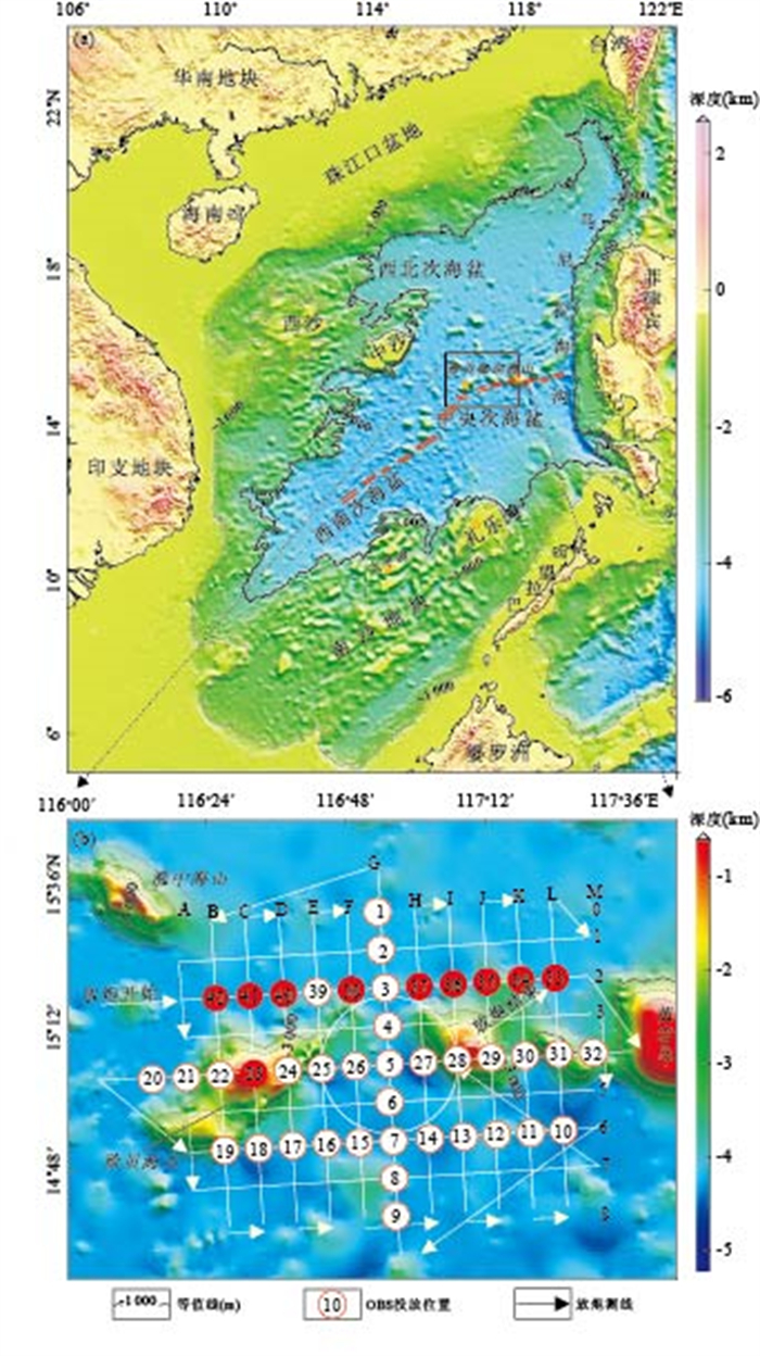
图 1 南海中央海盆OBS探测范围与测网布设
a.区域水深图,矩形框表示探测区域,红色双线表示扩张脊(据Briais et al., 1993);b.为OBS台阵及放炮测线的布设.白色圆圈表示国产OBS,红色圆圈表示德国OBS
Fig. 1. Key plan of OBS exploration in central sub-basin of SCS
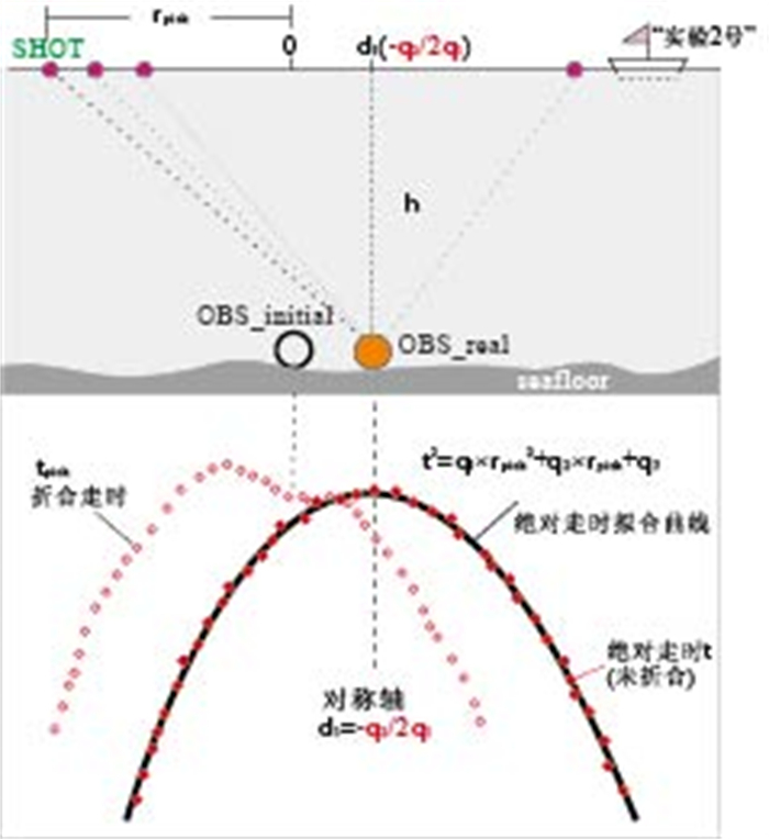
图 3 拟合直达水波走时曲线示意
Fig. 3. Schematic diagram of fitting the travel-time curve of direct water waves
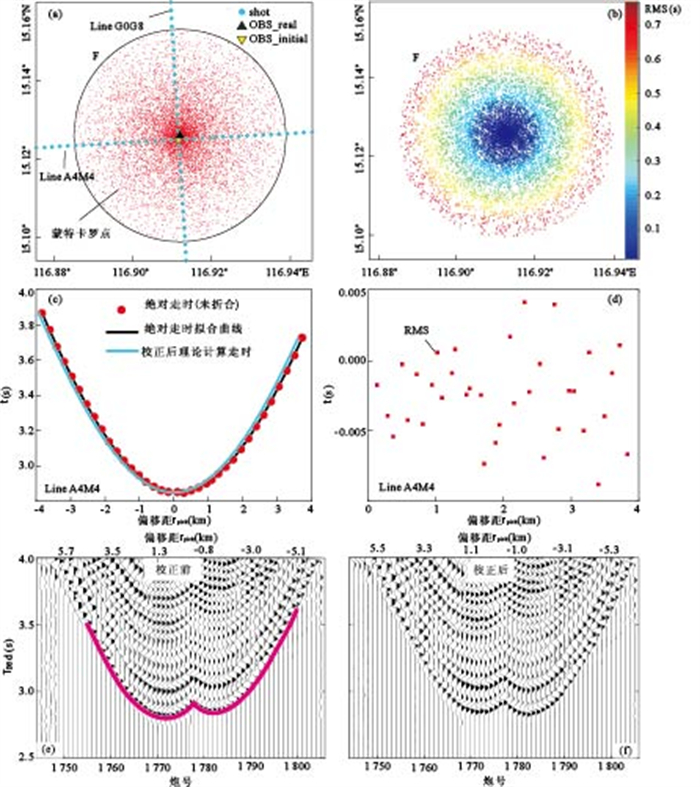
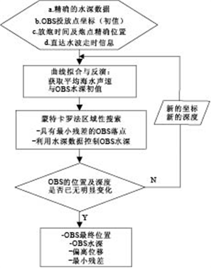
图 4 OBS05台站蒙特卡罗法位置校正
a.搜索最小残差点;b.所有残差分布;c.位置校正后,理论计算走时与绝对走时曲线对比;d.理论计算走时与绝对走时残差的均方根RMS分布;e, f.分别为OBS05台站A4M4测线位置校正前后直达水波特征对比的SEGY剖面图
Fig. 4. Monte-Carlo method for OBS05 positioning
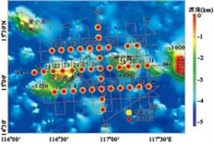
图 5 南海中央次海盆OBS位置校正结果及实际炮点测线
图中点线为校正后炮点,标记G0G8、L0L8和A4M4的测线分别对应于图 6中的SEGY剖面
Fig. 5. Results of OBS position correction in the central sub-basin of SCS
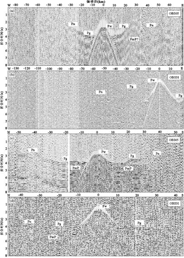
图 6 综合地震记录剖面与震相识别
a和b分别为OBS05与OBS31台站在相同炮点A4M4测线上的综合记录剖面;c.OBS05台站沿G0G8测线方向的记录剖面;d.OBS31台站沿L0L8测线方向的记录剖面图.其中折合速度均为6km/s,以上剖面均是OBS位置校正后的地震剖面,带通滤波器f=1,4,13,25Hz
Fig. 6. Seismic record sections of OBS05 and OBS31 and seismic phases identification
表 1 南海中央次海盆OBS位置校正结果
Table 1. Results of OBSs' relocation in the central sub-basin of SCS
OBS Before- location After- location Vw(km/s) h(m) RMS(s) D(m) t-adjust(s) Lon(°E) Lat(°N) Lon(°E) Lat(°N) to line1 to line2 all 1 116.88776 15.52209 116.88998 15.52274 1.500 4212.9 0.009 304.2 304.2 1.001 2 116.89381 15.42297 116.89373 15.41991 1.499 4226.5 0.018 426.5 -5.9 426.5 1.101 3 116.89957 15.32351 116.90009 15.32456 1.500 4111.0 0.011 70.7 106.0 127.4 0.050 4 116.90558 15.22435 116.90807 15.22508 1.494 4231.1 0.011 319.2 -97.9 333.9 0.000 5 116.91159 15.12497 116.91243 15.12553 1.502 4274.6 0.004 109.8 50.3 120.8 0.050 6 116.91748 15.02561 116.91795 15.02593 1.506 4182.3 0.009 37.1 653.1 654.2 0.170 7 116.92344 14.92671 116.92297 14.92755 1.501 4322.0 0.008 205.7 499.1 539.8 0.061 8 116.92975 14.82704 116.92950 14.83053 1.502 4225.2 0.017 -96.3 498.2 507.4 1.090 9 116.93618 14.72777 116.93702 14.72763 1.504 4261.0 0.008 90.1 226.2 243.5 1.020 10 117.38784 14.95242 117.38600 14.95113 1.500 4321.5 0.011 169.2 334.8 375.1 1.100 11 117.29437 14.94754 117.29294 14.94654 1.483 3937.4 0.026 390.8 -370.6 538.6 1.060 12 117.20200 14.94200 117.20022 14.93946 1.491 4283.1 0.051 586.2 756.6 957.1 -0.055 13 117.10926 14.93667 117.10756 14.93571 1.495 4282.5 0.011 -289.8 392.7 488.1 0.085 14 117.01644 14.93153 117.01500 14.93035 1.516 4281.5 0.026 375.4 -232.8 441.7 0.135 15 116.83071 14.92095 116.82988 14.92026 1.500 4281.0 0.010 -40.9 114.7 121.8 0.090 16 116.73806 14.91568 116.73726 14.91451 1.500 4287.8 0.008 157.9 -35.7 161.9 0.100 17 116.64523 14.90997 116.64450 14.90597 1.486 4079.1 0.022 146.1 -41.9 152.0 1.075 18 116.55244 14.90488 116.55288 14.90376 1.498 3792.9 0.008 286.1 286.1 0.060 19 116.45959 14.89932 116.46001 14.89806 1.508 2766.9 0.027 52.1 452.7 455.7 0.150 20 116.26139 15.08674 116.26161 15.08400 1.507 4295.5 0.007 -259.7 259.7 1.105 21 116.35446 15.09231 116.35423 15.09531 1.500 3954.0 0.002 -252.1 252.1 1.082 22 116.44692 15.09791 116.44823 15.09783 1.497 1 844.1 0.037 -150.7 221.0 267.5 0.150 23 116.54001 15.10333 116.54086 15.10278 1.499 949.1 0.044 35.7 88.6 95.5 0.210 24 116.63305 15.10878 116.63563 15.10502 1.504 1 900.0 0.013 -106.1 41.3 113.9 0.102 25 116.72640 15.11419 116.72707 15.11460 1.501 3566.2 0.013 85.7 392.3 401.6 -0.100 26 116.81962 15.11974 116.82019 15.11926 1.502 3977.0 0.024 36.1 354.3 356.1 0.000 27 117.00472 15.12999 117.00521 15.12835 1.505 4223.2 0.005 42.1 146.9 152.8 0.100 28 117.09750 15.13546 117.09819 15.13527 1.508 1 878.0 0.014 122.3 207.8 241.1 0.050 29 117.19049 15.14069 117.18822 15.14399 1.499 1016.2 0.112 -157.2 658.5 677.0 0.800 30 117.28335 15.14584 117.28379 15.14429 1.486 3733.0 0.230 -95.6 -169.6 194.7 -0.200 31 117.37630 15.15095 117.37619 15.15260 1.500 2338.8 0.011 16.7 14.1 21.9 0.122 34 117.27246 15.34454 117.27323 15.34515 1.447 3987.9 0.055 53.4 -165.9 174.3 0.084 35 117.17866 15.33927 117.17994 15.33973 1.500 4040.2 0.016 31.6 -239.1 241.2 0.169 37 116.99272 15.32902 116.99324 15.32892 1.500 4218.7 0.051 159.3 -84.5 180.3 0.200 38 116.80660 15.31809 116.80697 15.31963 1.500 4236.8 0.009 -115.6 -5.5 115.7 0.150 39 116.71365 15.31261 116.71390 15.31188 1.505 4211.0 0.027 -360.4 196.8 410.6 0.100 40 116.62066 15.30731 116.62042 15.30706 1.481 4216.4 0.036 -248.3 180.9 307.2 0.022 41 116.52764 15.30183 116.52730 15.30101 1.501 4292.7 0.023 358.1 584.9 685.8 0.115 42 116.43465 15.29644 116.43405 15.29540 1.501 4258.8 0.014 -709.7 16.5 709.9 0.120 注:(1)D为OBS沿某一放炮方向相对于校正前位置的偏离距离(line1表示东西向测线,line2表示南北向测线,后文同),以放炮方向为正;(2)Vw为反演过程中得到的海水波速,h为在重力水深数据控制下,通过反演得出OBS最终落点所对应的深度值;(3)RMS为走时残差的均方根.  下载: 导出CSV
表 2 OBS05与OBS21台站重复四次位置校正后的结果
Table 2. Results of four times relocation on OBS05 and OBS21
OBS 校正次数 Lon(°E) Lat(°N) h(m) RMS(s) 5 1 116.912 43 15.125 55 4 274.5 0.004 2 116.912 45 15.125 54 4 274.6 0.004 3 116.912 43 15.125 54 4 274.5 0.004 4 116.912 43 15.125 53 4 274.6 0.004 21 1 116.354 23 15.095 45 3 954.8 0.003 2 116.354 22 15.095 41 3 954.7 0.003 3 116.354 23 15.095 31 3 954.0 0.002 4 116.354 24 15.095 12 3 952.7 0.002
下载: 导出CSV
-
Ao, W., Zhao, M.H., Qiu, X.L., et al., 2010. The Correction of Shot and OBS Position in the 3D Seismic Experiment of the SW Indian Ocean Ridge. Chinese J. Geophys. , 53(6): 1072-1081 (in Chinese with English abstract). doi: 10.3969/j.issn.0001-5733.2010.12.022 Briais, A., Patriat, P., Tapponnier, P., 1993. Updated Interpretation of Magnetic Anomalies and Seafloor Spreading Stages in the South China Sea: Implications for the Tertiary Tectonics of Southeast Asia. J. Geophys. Res. , 98(B4): 6299-6328. doi: 10.1029/92JB02280 Cohen, J.K., Stockwell, J.W., 1995. The New SU User's Manual. Colorado School of Mines, USA, 1-40. Hao, T.Y., You, Q.Y., 2011. Progress of Homemade OBS and Its Application on Ocean Bottom Structure Survey. Chinese J. Geophys. , 54(12): 3352-3361 (in Chinese with English abstract). doi: 10.3969/j.issn.0001-5733.2011.12.033 Hao, T.Y., Xu, Y., Sun, F.L., et al., 2011. Integrated Geophysical Research on the Tectonic Attribute of Conjugate Continental Margin of South China Sea. Chinese J. Geophys. , 54(12): 3098-3116 (in Chinese with English abstract). doi: 10.3969/j.issn.0001-5733.2011.12.011 Li, C.F., Wang, P.X., Dieter, F., et al., 2009. Opening of the South China Sea and Its Implications for Southeast Asian Tectonics since the Late Mesozoic. Advances in Earth Science, 24(12): 1339-1351. (in Chinese with English abstract). http://en.cnki.com.cn/Article_en/CJFDTOTAL-DXJZ200912014.htm Li, J.B., Ding, W.W., Gao, J.Y., et al., 2011. Cenozoic Evolution Model of the Seafloor Spreading in South China Sea: New Constraints from High Resolution Geophysical Data. Chinese J. Geophys. , 54(12): 3004-3015 (in Chinese with English abstract). doi: 10.3969/j.issn.0001-5733.2011.12.003 Oshida, A., Kubota, R., Nishiyama, E., et al., 2008. A New Method for Determining OBS Positions for Crustal Structure Studies, Using Airgun Shots and Precise Bathymetric Data. Exploration Geophysics, 39, 15-25. doi: 10.1071/EG08005 Peirce, C., Day, A.J., 2002. Ocean-Bottom Seismograph Tomographic Experiments—A Consideration of Acquisition Geometries Vs. Resource. Geophys. J. Int. , 151, 543-565. doi: 10.1046/j.1365-246X.2002.01783.x Qiu, X.L., Chen Y., Zhu, R.X., et al., 2007. The Application of Large Volume Air Gun Sources to the Onshore-Offshore Seismic Surveys: Implication of the Experimental Results in Northern South China Sea. Chinese Science Bulletin, 52(4): 553-560. (in Chinese with English abstract). doi: 10.1007/s11434-007-0051-1 Qiu, X.L., Zhao, M.H., Xu, H.L., et al., 2012. Important Processes of Deep Seismic Surveys in the South China Sea: Retrospection and Expectation. Journal of Tropical Oceanography, 31(3): 1-8 (in Chinese with English abstract). http://www.cnki.com.cn/Article/CJFDTotal-RDHY201203002.htm Ruan, A.G., Li, J.B., Chen, Y.S., et al., 2010. The Experiment of Broad I-4C Type OBS in the Southwest India Ridge. Chinese J. Geophys. , 53(4): 1015-1018 (in Chinese with English abstract). doi: 10.3969/j.issn,0001-5733.2010.4.026 Shiobara, H., Nakanishi, A., Shimamura, H., et al., 1997. Precise Positioning of Ocean Bottom Seismometer by Using Acoustic Transponder and CTD. Marine Geophysical Researches, 19, 199-209. doi: 10.1023/A:1004246012551 Wang, P.X., 2009. Toward Scientific Breakthrough in the South China Sea. Journal of Tropical Oceanography, 28(3): 1-4. (in Chinese with English abstract). http://www.oalib.com/paper/1709126 Wang, Y.L., Yan, P., Zheng, H.B., et al., 2007. Timing and Positioning Corrections of Ocean Bottom Seismograph Data. Journal of Tropical Oceanography, 26(5): 40-46(in Chinese with English abstract). http://search.cnki.net/down/default.aspx?filename=RDHY200705007&dbcode=CJFD&year=2007&dflag=pdfdown Xue, B., Ruan, A.G., Li, X.Y., et al., 2008. The Seismic Data Corrections of Short Period Auto-Floating Ocean Bottom Seismometer. Journal of Marine Sciences, 26(2): 98-102 (in Chinese with English abstract). http://en.cnki.com.cn/Article_en/CJFDTOTAL-DHHY200802017.htm Yao, B.C., Zeng, W.J., Hayes, D.E., et al., 1994. The Geological Memoir of South China Sea Surveyed Jointly by China & USA. China University of Geosciences Press, Wuhan, 204 (in Chinese). Zhao, M.H., Qiu, X.L., Xia, S.H., et al., 2008. Large Volume Air-Gun Sources and Its Seismic Waveform Characters. Chinese J. Geophys. , 51(2): 558-565 (in Chinese with English abstract). http://www.oalib.com/paper/1569329 敖威, 赵明辉, 丘学林, 等, 2010. 西南印度洋中脊三维地震探测中炮点与海底地震仪的位置校正. 地球物理学报, 53(12): 2982-2991. doi: 10.3969/j.issn.0001-5733.2010.12.022 郝天珧, 徐亚, 孙福利, 等, 2011. 南海共轭大陆边缘构造属性的综合地球物理研究. 地球物理学报, 54(12): 3098-3116. doi: 10.3969/j.issn.0001-5733.2011.12.011 郝天珧, 游庆瑜, 2011. 国产海底地震仪研制现状及其在海底结构探测中的应用. 地球物理学报, 54(12): 3352-3361. doi: 10.3969/j.issn.0001-5733.2011.12.033 李春峰, 汪品先, Dieter, F., 等, 2009. 南海张裂过程及其对晚中生代以来东南亚构造的启示——IODP建议书735Full介绍. 地球科学进展, 24(12): 1339-1351. doi: 10.3321/j.issn:1001-8166.2009.12.008 李家彪, 丁巍伟, 高金耀, 等, 2011. 南海新生代海底扩张的构造演化模式: 来自高分辨率地球物理数据的新认识. 地球物理学报, 54(12): 3004-3015. doi: 10.3969/j.issn.0001-5733.2011.12.003 丘学林, 陈颙, 朱日祥, 等, 2007. 大容量气枪震源在海陆联测中的应用: 南海北部试验结果分析. 科学通报, 52(4): 463-469. doi: 10.3321/j.issn:0023-074X.2007.04.015 丘学林, 赵明辉, 徐辉龙, 等, 2012. 南海地震探测重要科学进程: 回顾和展望. 热带海洋学报, 31(3): 1-8. https://www.cnki.com.cn/Article/CJFDTOTAL-RDHY201203002.htm 阮爱国, 李家彪, 陈永顺, 等, 2010. 国产I-4C型OBS在西南印度洋中脊的试验. 地球物理学报, 53(4): 1015-1018. doi: 10.3969/j.issn.0001-5733.2010.04.026 汪品先, 2009. 南海—我国深海研究的突破口. 热带海洋学报, 28(3): 1-4. doi: 10.3969/j.issn.1009-5470.2009.03.001 王彦林, 阎贫, 郑红波, 等, 2007. OBS记录的时间和定位误差校正. 热带海洋学报, 26(5): 40-46. doi: 10.3969/j.issn.1009-5470.2007.05.007 薛彬, 阮爱国, 李湘云, 等, 2008. SEDIS-IV型短周期自浮式海底地震仪数据校正方法. 海洋学研究, 26(2): 98-102. doi: 10.3969/j.issn.1001-909X.2008.02.014 姚伯初, 曾维军, Hayes, D.E., 等, 1994. 中美合作调研南海地质专报. 武汉: 中国地质大学出版社, 204. 赵明辉, 丘学林, 夏少红, 等, 2008. 大容量气枪震源及其波形特征. 地球物理学报, 51(2): 558-565. doi: 10.3321/j.issn:0001-5733.2008.02.028 -

 点击查看大图
计量
- 文章访问数: 4077
- HTML全文浏览量: 677
- PDF下载量: 370
- 被引次数: 0
