


Mapping Buried Faults Using the Temperature-Vegetation-Dryness Index with an Application in Yangla Copper Mining Area, Yunnan
-
摘要: 在残积物、土壤覆盖区,若基岩中存在断层,则可能使局部覆盖层加厚、湿度和植被密度相对提高、近地面物质热惯量加大,并在白天的热红外观测中因地表升温较慢而显示地面温度相对较低.这些效应可用温度植被干旱指数(TVDI)加以表征,TVDI的线状低值区(负异常)可作为指示隐伏断层的标志.利用Landsat7 ETM+数据,运用温度植被干旱指数(TVDI)方法,在面积约26 km2的云南羊拉铜矿区进行了隐伏断层识别.结合可见光遥感影像解译及露头地段实地调查,测制了该矿区断层分布图.该研究成果对于羊拉矿区矿山生产有一定的实际意义,同时也显示了热红外遥感技术在覆盖区矿区地质应用方面的潜力.Abstract: In mountainous areas with eluvium overburden, thickness, moisture and vegetation of the overburden layer may be locally increased where faults are developed in the bedrock. At such localities thermal inertia of the near-surface materials is larger than that in the surrounding areas and relatively low surface temperature due to slower diurnal heating rate may be observed in the daytime. Therefore, the temperature-vegetation-dryness index (TVDI), a combination of surface temperature and vegetation, may be used to retrieve buried faults. Using Landsat7 ETM+ data, we have identified buried faults in this study with TVDI in Yangla copper mining district, Yunnan, which is about 26 km2 in area and is covered by residual deposits for the most part. A distribution map of faults of the district is obtained with linear lows of TVDI as indicators of buried faults combined with visible image interpretation and field investigation. While essential for mining practice in Yangla, our results show a remarkable potential of thermal infrared remote sensing in ore-field geological studies in poorly outcropped regions.
-

图 1 羊拉矿区ETM+影像Ts-NDVI特征空间散点图及拟合的干、湿边(黑三角与黑圆点为一定NDVI对应的Ts的最小值和最大值;R2为相关系数)
Fig. 1. Ts-NDVI space scatter plot of an ETM+ image in Yangla copper mining area, with fitted dry and wet edges
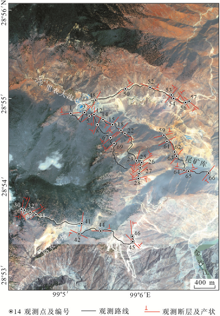
图 2 羊拉矿区GeoEye-1真彩色影像及地质调查路线
Fig. 2. GeoEye-1 true color image of Yangla copper mining area with field investigation routes shown

图 3 羊拉矿区温度植被干旱指数影像及断层综合解译图(虚线框表示的位置见正文中说明)
Fig. 3. Temperature-vegetation-dryness index image of Yangla copper mining area, with interpreted faults shown
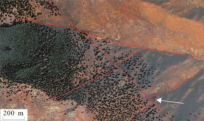
图 5 矿区北部(图 3的B处)GeoEye-1真彩色影像(白色箭头处见北东向负地形被北西向断层切错)
Fig. 5. GeoEye-1 true color image showing relations between different faults
-
Bateson, L., Vellico, M., Beaubien, S.E., et al., 2008. The Application of Remote-Sensing Techniques to Monitor CO2-Storage Sites for Surface Leakage: Method Development and Testing at Latera (Italy) Where Naturally Produced CO2 Is Leaking to the Atmosphere. International Journal of Greenhouse Gas Control, 2(3): 388-400. doi: 10.1016/j.ijggc.2007.12.005 Carlson, T.N., Gillies, R.R., Perry, E.M., 1994. A Method to Make Use of Thermal Infrared Temperature and NDVI Measurements to Infer Surface Soil Water Content and Fractional Vegetation Cover. Romote Sensing Reviews, 9(1-2): 161-173. doi: 10.1080/02757259409532220 Cui, X.F., Xie, F.R., Zhang, H.Y., 2006. Recent Tectonic Stress Field Zoning in Sichuan-Yunnan Region and Its Dynamic Interest. Acta Seismologica Sinica, 19(5): 485-496. doi: 10.1007/s11589-006-0501-x Genzano, N., Aliano, C., Pergola, N., et al., 2007. A Robust Satellite Technique for Monitoring Seismically Active Areas: The Case of Bhuj-Gujarat Earthquake. Tectonophysics, 431(1-4): 197-210. doi: 10.1016/j.tecto.2006.04.024 Goetz, S.J., 1997. Multi-Sensor Analysis of NDVI, Surface Temperature and Biophysical Variables at a Mixed Grassland Site. International Journal of Remote Sensing, 18(1): 71-94. doi: 10.1080/014311697219286 Goward, S.N., Xue, Y.K., Czajkowski, K.P., 2002. Evaluating Land Surface Moisture Conditions from the Remotely Sensed Temperature/Vegetation Index Measurements: An Exploration with the Simplified Simple Biosphere Model. Remote Sensing of Environment, 79(2-3): 225-242. doi: 10.1016/S0034-4257(01)00275-9 Ji, Q., He, L.L., Yu, M., et al., 2009. Study on Relationship between Land Use and Urban Heat Islands Based on Landsat ETM+ Remote Sensing Data. Journal of Fujian Normal University (Natural Science Edition), 25(6): 106-113(in Chinese with English abstract). Liu, F.J., Wu, G.P., Guo, Y., et al., 2008. Extraction of Oil and Gas Haloes Based on ETM+ Data: A Case Study from Yakela, Xinjiang. Earth Science—Journal of China University of Geosciences, 33(1): 107-111(in Chinese with English abstract). doi: 10.3799/dqkx.2008.014 Moran, M.S., Clarke, T.R., Inoue, Y., et al., 1994. Estimating Crop Water Deficit Using the Relation between Surface-Air Temperature and Spectural Vegetation Index. Remote Sensing of Environment, 49(3): 246-263. doi: 10.1016/0034-4257(94)90020-5 Pulinets, S.A., Ouzounov, D., Karelin, A.V., et al., 2006. The Physical Nature of Thermal Anomalies Observed before Strong Earthquakes. Physics and Chemistry of the Earth, 31(4-9): 143-153. doi: 10.1016/j.pce.2006.02.042 Pulinets, S.A., Dunajecka, M.A., 2007. Specific Variations of Air Temperature and Relative Humidity around the Time of Michoacan Earthquake M8.1 Sept. 19, 1985 as a Possible Indicator of Interaction between Tectonic Plates. Tectonophysics, 431(1-4): 221-230. doi: 10.1016/j.tecto.2006.05.044 Qi, S.H., Wang, C.Y., Niu, Z., 2003. Evaluating Soil Moisture Status in China Using the Temperature/Vegetation Dryness Index(TVDI). Journal of Remote Sensing, 7(5): 420-427 (in Chinese with English abstract). http://www.oalib.com/paper/1468949 Qian, X.D., Qin, J.Z., Liu, L.F., 2011. Study on the Recent Tectonic Stress Field in the Yunnan Region. Earthquake Research in China, 25(4): 410-425. http://www.researchgate.net/publication/287560169_Study_on_recent_tectonic_stress_field_in_Yunnan_region Qiang, Z.J., Kong, L.C., Guo, M.H., et al., 1997. An Experimental Study of Temperature Increasing Mechanism of Satellitic Thermoinfrared. Acta Seismologica Sinica, 19(2): 197-201 (in Chinese). doi: 10.1007/s11589-997-0093-0 Qin, Z.H., Li, W.J., Xu, B., 2004. The Estimation of Land Surface Emissivity for Landsat TM6. Remote Sensing for Land & Resources, 3: 29-42 (in Chinese with English abstract). http://www.researchgate.net/publication/292600766_The_estimation_of_land_surface_emissivity_for_landsat_TM6 Qu, C.Y., Ma, J., Shan, X.J., 2007. An Attempt to Observe Gas Releasing Phenomena of the Earth by Using Satellite Thermal Infrared Technique. Seismology and Geology, 26(3): 539-547 (in Chinese with English abstract). http://www.researchgate.net/publication/286917058_An_attempt_to_observe_gas_releasing_phenomena_of_the_earth_by_using_satellite_thermal_infrared_technique Sandholt, I., Rasmussen, K., Andersen, J., 2002. A Simple Interpretation of the Surface Temperature/ Vegetation Index Space for Assessment of Surface Moisture Status. Remote Sensing of Environment, 79(2-3): 213-224. doi: 10.1016/S0034-4257(01)00274-7 Sobrino, J.A., Li, Z.L., Stoll, M.P., et al., 1994. Improvements in the Split-Window Technique for Landsurface Temperature Determination. IEEE Transactions on Geosciences and Remote Sensing, 32: 243-253. doi: 10.1109/36.295038 Surkov, V.V., Pokhotelov, O.A., Parrot, M., et al., 2006. On the Origin of Stable IR Anomalies Detected by Satellites above Seismo-Active Regions. Physics and Chemistry of the Earth, 31(4-9): 164-171. doi: 10.1016/j.pce.2006.02.020 Tronin, A.A., Masashi, H., Molchanov, O.A., 2002. Thermal IR Satellite Data Application for Earthquake Research in Japan and China. Journal of Geodynamics, 33(4-5): 519-534. doi: 10.1016/S0264-3707(02)00013-3 Van de Griend, A.A., Owe, M., 1993. On the Relationship between Thermal Emissivity and the Normalized Difference Vegetation Index for Natural Surfaces. International Journal of Remote Sensing, 14(6): 1119-1131. doi: 10.1080/01431169308904400 Van der Meer, F.D., Van der Werff, H.M.A., Van Ruitenbeek, F.J.A., et al., 2012. Multi- and Hyperspectral Geologic Remote Sensing: A Review. International Journal of Applied Earth Observation and Geoinformation, 14(1): 112-128. doi: 10.1016/j.jag.2011.08.002 Wu, M.C., Ding, J.L., Wang, G.F., 2012. Regional Soil Moisture Inversion Based on Surface Temperature and Vegetation Index Characteristic Spaces. Journal of Desert Research, 32(1): 148-154 (in Chinese with English abstract). http://en.cnki.com.cn/Article_en/CJFDTOTAL-ZGSS201201022.htm Wu, W.Y., Zou, L.J., Shen, X.H., et al., 2012. Thermal Infrared Remote-Sensing Detection of Thermal Information Associated with Faults: A Case Study in Western Sichuan Basin, China. Journal of Asian Earth Sciences, 43(1): 110-117. doi: 10.1016/j.jseaes.2011.08.015 Zheng, G.Q., Lu, M., Zhang, T., et al., 2010. The Impact of Difference of Land Surface Emissivity on the Land Surface Temperature Retrieval of Jinan City. Journal of Shandong Jianzhu University, 25(5): 519-523(in Chinese with English abstract). http://en.cnki.com.cn/Article_en/CJFDTOTAL-SDJG201005011.htm Zheng, L.Z., Qiang, Z.J., Lin, C.G., 1996. Practice and Research on Short Term Impending Earthquake Prediction by Interpreting Satellite Thermal Infrared Anomaly Image. Earth Science—Journal of China University of Geosciences, 21(6): 665-668 (in Chinese with English abstract). 季青, 贺伶俐, 余明, 等, 2009. 基于LandsatETM+数据的福州市土地利用/覆被与城市热岛的关系研究. 福建师范大学学报(自然科学版), 25(6): 106-113. https://www.cnki.com.cn/Article/CJFDTOTAL-FJSZ200906023.htm 刘福江, 吴国平, 郭艳, 等, 2008. 基于ETM+遥感影像油气晕反演: 以新疆雅克拉地区为例. 地球科学——中国地质大学学报, 33(1): 107-111. https://www.cnki.com.cn/Article/CJFDTOTAL-DQKX200801017.htm 齐述华, 王长耀, 牛铮, 2003. 利用温度植被旱情指数(TVDI)进行全国旱情监测研究. 遥感学报, 7(5): 420-427. https://www.cnki.com.cn/Article/CJFDTOTAL-YGXB200305012.htm 强祖基, 孔令昌, 郭满红, 等, 1997. 卫星热红外增温机制的实验研究. 地震学报, 19(2): 197-201. https://www.cnki.com.cn/Article/CJFDTOTAL-DZXB702.009.htm 覃志豪, 李文娟, 徐斌, 等, 2004. 陆地卫星TM6波段范围内地表比辐射率的估计. 国土资源遥感, 3: 29-42. https://www.cnki.com.cn/Article/CJFDTOTAL-GTYG200403007.htm 屈春燕, 马瑾, 单新建, 2004. 利用卫星热红外观测地球排气现象的一次尝试. 地震地质, 26(3): 539-547. doi: 10.3969/j.issn.0253-4967.2004.03.018 伍漫春, 丁建丽, 王高峰, 2012. 基于地表温度—植被指数特征空间的区域土壤水分反演. 中国沙漠, 32(1): 148-154. https://www.cnki.com.cn/Article/CJFDTOTAL-ZGSS201201022.htm 郑国强, 鲁敏, 张涛, 等, 2010. 地表比辐射率求算对济南市地表温度反演结果的影响. 山东建筑大学学报, 25(5): 519-523. doi: 10.3969/j.issn.1673-7644.2010.05.012 郑兰哲, 强祖基, 赁常恭, 1996. 卫星热红外影像在地震短临预报中的应用. 地球科学——中国地质大学学报, 21(6): 665-668. https://www.cnki.com.cn/Article/CJFDTOTAL-DQKX606.031.htm -

 下载:
下载:

 点击查看大图
计量
- 文章访问数: 3243
- HTML全文浏览量: 683
- PDF下载量: 537
- 被引次数: 0
