


Vertical Accuracy Assessment of SRTM and ASTER GDEM over Typical Regions of China Using ICESat/GLAS
-
摘要: 航天飞机雷达地形测绘(shuttle radar topography mission, SRTM)和先进星载热发射和反射辐射成像仪全球数字高程模型(advanced spaceborne thermal emission and reflection radiometer global digital elevation model, ASTER GDEM)提供了全球覆盖面积最广的数字高程模型(digital elevation model, DEM)数据, 但其高程精度还未得到充分验证, 传统地面测量方法很难适用于验证大面积范围的DEM精度.以冰、云和陆地高程卫星/地学激光测高系统(ICESat/GLAS)高程数据为参考, 综合利用地理信息系统(geographic information system, GIS)空间分析、三维可视化与统计分析方法, 对中国典型低海拔沿海平原地区和高海拔山地的两种DEM数据高程精度进行了对比分析.结果表明, 高程值小于20m的低海拔地区, SRTM高程精度达到2.39m, ASTER GDEM的精度达到4.83m, 均远远高于这两种数据的标称精度; 而在西南山地, 这两种DEM的精度大约为20m, 与标称精度相当.最后, 建立了ICESat/GLAS与SRTM和ASTER GDEM的一元线性回归模型, 该模型具有较高的拟合度和显著线性关系, 可用于改善这两种DEM的高程精度.Abstract: SRTM (shuttle radar topography mission) and ASTER GDEM (advanced spaceborne thermal emission and reflection radiometer global digital elevation model), the most accurate and available global DEM (digital elevation model) data, cover nearly the entire land surface of the earth. However, the precision of these DEM data has not been fully validated. This paper focuses on Chinese typical regions, aiming to verify the elevation precision of SRTM and ASTER GDEM based on ICESat / GLAS (ice, cloud, and land elevation satellite/geoscience laser altimeter system) elevation data by utilization of GIS (geographic information system) spatial analysis, 3D visualization and statistical analysis methods. The results show that SRTM elevation precision reaches 2.39m, and ASTER GDEM precision reaches 4.83m in the low altitude areas where the elevation value is less than 20m. The elevation precision is higher than the specified precision in both cases. However, the precision in Southwest study area is similar to the specified precision. The established linear regression model in the present study has high goodness of fit and significant correlation, but the applicability of the model needs further study.
-
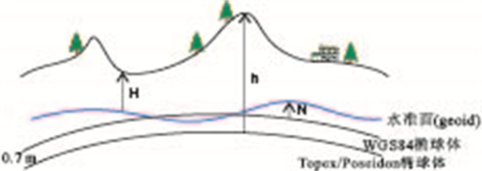
图 2 从GLA14产品提取的各参数之间的关系以及WGS84椭球体与Topex/Poseidon椭球体之间的关系
Fig. 2. Relation of elevation parameters extracted from GLA14 and the relation between WGS84 ellipsoid elevation and Topex/Poseidon ellipsoid elevation
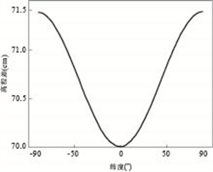
图 3 以Topex/Poseidon椭球体为参考的高程与以WGS84椭球体为参考的高程之差在全球范围内的分布
Fig. 3. Elevation differences distribution between Topex/Poseidon and WGS84 (90°N to 90°S)
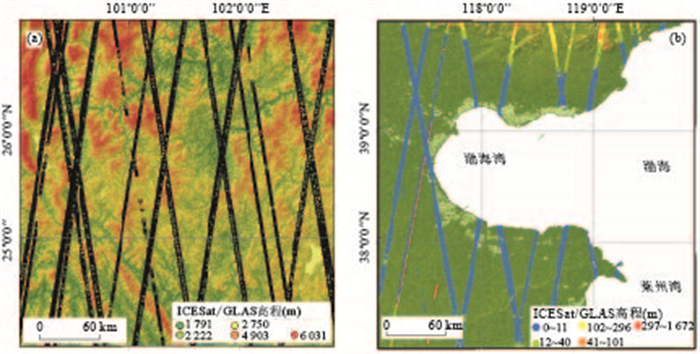
图 4 ICESat/GLAS数据叠加SRTM DEM数据
a.为西南研究区;b.为环渤海研究区;其中橙色与红色为粗差点
Fig. 4. ICESat/GLAS data overlaid SRTM DEM data
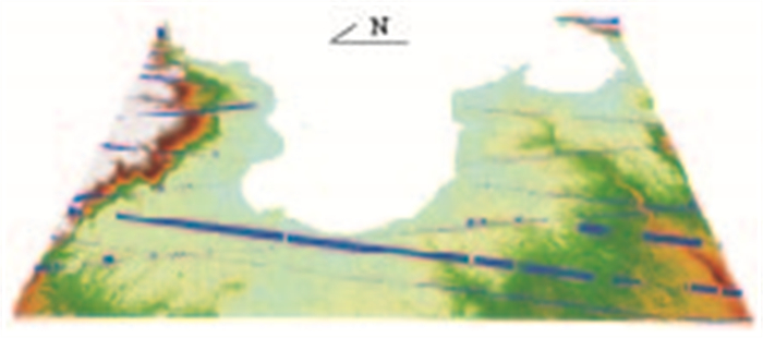
图 5 三维视图下的ICESat/GLAS数据叠加SRTM DEM数据(环渤海研究区)
Fig. 5. ICESat/GLAS data overlaid SRTM DEM data (Bohai gulf study area) in three-dimensional view
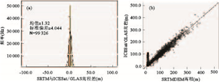
图 6 SRTM与ICESat/GLAS高程统计分析
a为环渤海研究区SRTM与ICESat/GLAS高程差的频率统计直方图,b为环渤海研究区SRTM和ICESat/GLAS数据的散点图与一元线性回归拟合
Fig. 6. SRTM and ICESat/GLAS elevation statistical analysis in the Bohai gulf study area

图 7 高程差直方图统计分析
a.环渤海研究区域SRTM-ICESat/GLAS的高程差直方图统计;b.环渤海研究区域ASTERGDEM-ICESat/GLAS的高程差直方图统计;c.西南研究区域SRTM-ICESat/GLAS的高程差直方图统计;d.西南研究区域ASTER GDEM-ICESat/GLAS的高程差直方图统计
Fig. 7. Histogram analysis of elevation difference
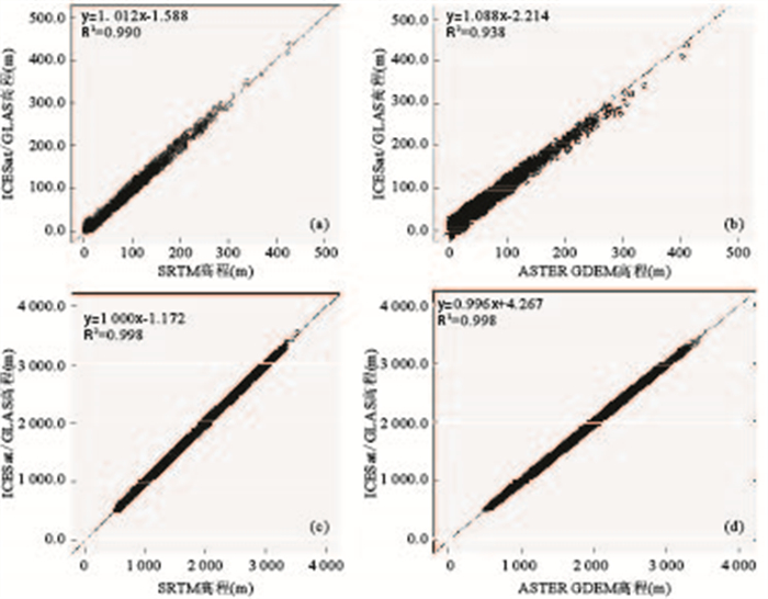
图 8 SRTM高程和ICESat/GLAS高程值的线性回归拟合
a.环渤海研究区域SRTM和ICESat/GLAS的线性回归拟合;b.环渤海研究区域ASTERGDEM和ICESat/GLAS的线性回归拟合;c.西南研究区域SRTM和ICESat/GLAS的线性回归拟合;d.西南研究区域ASTER GDEM和ICESat/GLAS的线性回归拟合
Fig. 8. Correlation between DEM elevation and ICESat/GLAS elevation
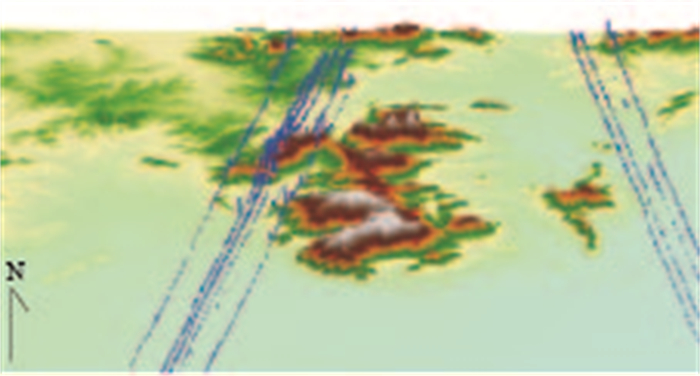
图 9 DEM高程精度与地形的关系三维可视化分析.将高程差(3D夸张因子为10)在三维视图下拉升,叠加到三维DEM模型的场景
Fig. 9. Three-dimensional visualization analysis of the relationship between DEM elevation accuracy and terrain (3D exaggeration factor of elevation difference is 10)
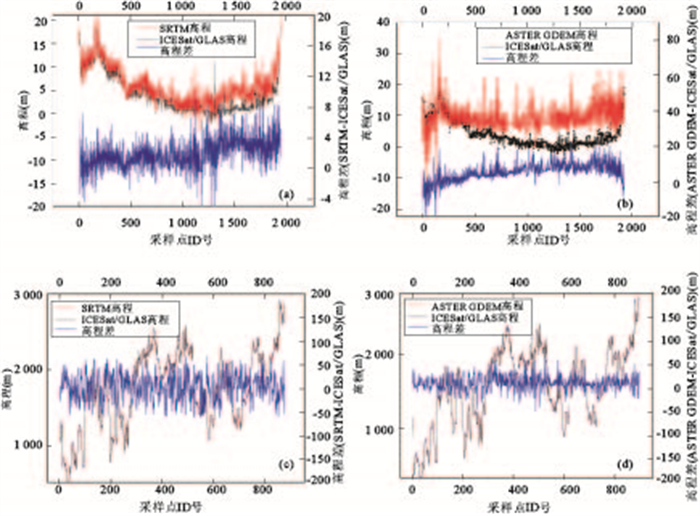
图 10 ICESat/GLAS和DEM的高程曲线和高程差对比
a.渤海研究区的ICESat/GLAS和SRTM的高程曲线和高程差;b.渤海研究区的ICESat/GLAS和ASTER GDEM的高程曲线和高程差;c.西南研究区的ICESat/GLAS和SRTM的高程曲线和高程差;d.西南研究区的ICESat/GLAS和ASTER GDEM的高程曲线和高程差
Fig. 10. Comparative analysis of elevation profile and elevation difference
表 1 高程值描述统计分析
Table 1. Descriptive statistics of elevation
统计参数 环渤海区域 西南地区 ICESat/GLAS SRTM ASTER ICESat/GLAS SRTM ASTER 样本点数 99326 99326 109318 141697 141697 141738 均值(m) 12.69 14.01 11.93 1871.67 1873.44 1875.19 标准差(m) 23.81 23.37 19.61 427.67 427.26 429.22 中位数(m) 5.44 7.00 7.00 1900.68 1902.00 1903.00 最大值(m) 438.89 423.00 412.00 3540.12 3500.00 3548.00 最小值(m) 0.00 0.00 1.00 498.90 503.00 496.00  下载: 导出CSV
表 2 二次剔除粗差后的基础描述统计分析
Table 2. Descriptive analysis of elevation after the second outlier removal
统计参数 环渤海区域 西南地区 ICESat/GLAS SRTM ASTER ICESat/GLAS SRTM ASTER 样本点数 98764 98764 108704 140116 140116 140060 均值(m) 12.07 13.50 11.74 1871.79 1873.39 1873.49 标准差(m) 21.76 21.39 19.07 427.17 426.77 428.62 最大值(m) 438.89 423.00 412.00 3540.12 3500.00 3548.00 最小值(m) 0.00 1.00 1.00 498.90 503.00 496.00
下载: 导出CSV
表 3 高程差统计值
Table 3. The statistical value of elevation difference
统计参数 环渤海区域 西南研究区 SRTM-GLAS ASTER-GLAS SRTM-GLAS ASTER-GLAS 样本点数 98764 108704 140116 140060 均值(m) 1.42 1.18 1.60 3.51 标准差(m) 2.21 5.59 20.65 19.05 RMSE(m) 2.62 5.71 20.71 19.37 方差(m) 4.87 31.22 426.30 362.89
下载: 导出CSV
表 4 环渤海研究区域分类高程差统计
Table 4. Statistics by classification of elevation difference in Bohai gulf study area
统计参数 环渤海区域(<20m) 环渤海区域(>20m) SRTM-GLAS ASTER-GLAS SRTM-GLAS ASTER-GLAS 样本点数 86005 98506 12759 10198 均值(m) 1.49 1.91 0.93 -5.90 标准差(m) 1.86 4.43 3.75 9.36 RMSE(m) 2.39 4.83 3.86 11.07 方差(m) 3.46 19.67 14.07 87.68
下载: 导出CSV
表 5 西南研究区分类高程差统计
Table 5. Statistics by classification of elevation difference in Southwest study area
统计参数 西南研究区(<1870m) 西南研究区(>1870m) SRTM-GLAS ASTER-GLAS SRTM-GLAS ASTER-GLAS 样本点数(m) 63851 64187 76265 75873 均值(m) 1.55 2.25 1.64 4.58 标准差(m) 20.65 17.92 20.64 19.90 RMSE(m) 20.71 18.06 20.71 20.42 方差(m) 426.51 320.98 426.11 396.05
下载: 导出CSV
-
Abshire, J.B., X. Sun, Riris, H., et al., 2005. Geoscience Laser Altimeter System (GLAS) on the ICESat Mission: On-Orbit Measurement Performance. Geophysical Research Letters, 32(21): L21S02. doi: 10.1029/2005GL024028 ASTER GDEM Validation Team, 2009. ASTER Global DEM Validation, Summary Report. Available at: https://lpdaac.usgs.gov/sites/default/files/public/aster/docs/ASTER_GDEM_Validation_Summary_Report.pdf. Accessed 15th May 2013. Bhang, K.J., F.W. Schwartz, Braun, A. 2007. Verification of the Vertical Error in C-Band SRTM DEM Using ICESat and Landsat-7, Otter Tail County, MN. IEEE Transactions on Geoscience and Remote Sensing, 45(1): 36-44. doi: 10.1109/TGRS.2006.885401 Carabajal, C.C., Harding, D.J., 2005. ICESat Validation of SRTM C-Band Digital Elevation Models. Geophysical Research Letters, 32(22): L22S01. doi: 10.1029/2005GL023957 Carabajal, C.C., Harding, D.J., 2006. SRTM C-Band and ICES at Laser Altimetry Elevation Comparisons as a Function of Tree Cover and Relief. Photogrammetric Engineering and Remote Sensing, 72(3): 287-298. doi: 10.14358/PERS.72.3.287 Chen, J.Y., 2005. Quality Evaluation of Topographic Data from SRTM3 and GTOPO30. Geomatics and Information Science of Wuhan University, 30(11): 941-944 (in Chinese with English abstract). http://www.wanfangdata.com.cn/details/detail.do?_type=perio&id=whchkjdxxb200511001 E, D.C., Shen, Q., Xu, Y., et al., 2009. High-Accuracy Topographical Information Extraction Based on Fusion of ASTER Stereo-Data and ICESat/GLAS Data in Antarctica. Science in China (Series D): Earth Sciences, 39(3): 351-359 (in Chinese with English abstract). http://www.cnki.com.cn/Article/CJFDTotal-JDXG200905015.htm Farr, T.G., Rosen, P.A., Caro, E., 2007. The Shuttle Radar Topography Mission. Reviews of Geophysics, 45(2). doi: 10.1029/2005RG000183 Gorokhovich, Y., Voustianiouk, A., 2006. Accuracy Assessment of the Processed SRTM-Based Elevation Data by CGIAR Using Field Data from USA and Thailand and Its Relation to the Terrain Characteristics. Remote Sensing of Environment, 104(4): 409-415. doi: 10.1016/j.rse.2006.05.012 Hirt, C., Filmer, M., Featherstone, W., 2010. Comparison and Validation of the Recent Freely Available ASTER-GDEM Ver1, SRTM Ver4.1 and GEODATA DEM-9S Ver 3 Digital Elevation Models over Australia. Australian Journal of Earth Sciences, 57(3): 337-347. doi: 10.1080/08120091003677553 Hvidegaard, S.M., Sørensen, L.S., Forsberg, R., 2011. ASTER GDEM Validation Using LiDAR Data over Coastal Regions of Greenland. Remote Sensing Letters, 3(1): 85-91. doi: 10.1080/01431161.2010.527389 Koch, A., Lohmann, P., 2000. Quality Assessment and Validation of Digital Surface Models Derived from the Shuttle Radar Topography Mission (SRTM). Proceedings, IAPRS, 33. http://ieeexplore.ieee.org/document/978187/ Nikolakopoulos, K.G., Kamaratakis, E.K., Chrysoulakis, N., 2006. SRTM vs. ASTER Elevation Products. Comparison for Two Regions in Crete, Greece. International Journal of Remote Sensing, 27(21): 4819-4838. doi: 10.1080/01431160600835853 Rabus, B., Eineder, M., Roth, A., et al., 2003. The Shuttle Radar Topography Mission—A New Class of Digital Elevation Models Acquired by Spaceborne Radar. ISPRS Journal of Photogrammetry and Remote Sensing, 57(4): 241-262. doi: 10.1016/S0924-2716(02)00124-7 Reuter, H.I., Nelson, A., Strobl, P., et al., 2009. A First Assessment of Aster GDEM Tiles for Absolute Accuracy, Relative Accuracy and Terrain Parameters, IGARSS, 12-17 July 2009, Cape Town, IEEE. doi: 10.1109/IGARSS.2009.5417688 Rodriguez, E., Morris, C.S., Belz, J.E., 2006. A Global Assessment of the SRTM Performance. Photogrammetric Engineering and Remote Sensing, 72(3): 249-260. doi: 10.14358/PERS.72.3.249 Schutz, B. E, Zwally, H.J., Shuman, C.A., et al., 2005. Overview of the ICESat Mission. Geophysical Research Letters, 32(21): L21S01. doi: 10.1029/2005GL024009 Simard, M., Rivera-Monroy, V.H., Mancera-Pindeda, J.E., et al., 2008. A Systematic Method for 3D Mapping of Mangrove Forests based on Shuttle Radar Topography Mission Elevation Data, ICESat/GLAS Waveforms and Field Data: Application to CiÉNaga Grande de Santa Marta, Colombia. Remote Sensing of Environment, 112(5): 2131-2144. doi: 10.1016/j.rse.2007.10.012 Sun, G., Ranson, K., Kharuk, V., et al., 2003. Validation of Surface Height from Shuttle Radar Topography Mission Using Shuttle Laser Altimeter. Remote Sensing of Environment, 88(4): 401-411. doi: 10.1016/j.rse.2003.09.001 Sun, G., Ranson, K., Kimes, D., et al., 2008. Forest Vertical Structure from GLAS: An Evaluation Using LVIS and SRTM Data. Remote Sensing of Environment, 112(1): 107-117. doi: 10.1016/j.rse.2006.09.036 Tang, C., Qi, X., Ding, J., et al., 2010. Dynamic Analysis on Rainfall-Induced Landslide Activity in High Seismic Intensity Areas of the Wenchuan Earthquake Using Remote Sensing Image. Earth Science—Journal of China University of Geosciences, 35(2): 317-323 (in Chinese with English abstract). doi: 10.3799/dqkx.2010.033 Toutin, T., 2002. Impact of Terrain Slope and Aspect on Radargrammetric DEM Accuracy. ISPRS Journal of Photogrammetry and Remote Sensing, 57(3): 228-240. doi: 10.1016/S0924-2716(02)00123-5 Toutin, T., 2008. ASTER Dems for Geomatic and Geoscientific Applications: A Review. International Journal of Remote Sensing, 29(7): 1855-1875. doi: 10.1080/01431160701408477 Wang, X., Zhou, A.G., Siegert, F., et al., 2012. Glacier Temporal-Spatial Change Characteristics in Western Nyainqentanglha Range, Tibetan Plateau 1977-2010. Earth Science—Journal of China University of Geosciences, 37(5): 1082-1092 (in Chinese with English abstract). http://en.cnki.com.cn/Article_en/CJFDTOTAL-DQKX201205024.htm Ye, Q.H., Yao, T.D., Chen, F., et al., 2008. Response of Glacier and Lake Covariations to Climate Change in Mapam Yumco Basin on Tibetan Plateau during 1974-2003. Journal of China University of Geosciences, 19(2): 135-145. doi: 10.1016/S1002-0705(08)60032-1 陈俊勇, 2005. 对SRTM3和GTOPO30地形数据质量的评估. 武汉大学学报(信息科学版), 30(11): 941-944. https://www.cnki.com.cn/Article/CJFDTOTAL-WHCH200511001.htm 鄂栋臣, 沈强, 徐莹, 等, 2009. 基于ASTER立体数据和ICESat/GLAS测高数据融合高精度提取南极地区地形信息. 中国科学(D辑: 地球科学), 39(3): 351-359. https://www.cnki.com.cn/Article/CJFDTOTAL-JDXK200903011.htm 唐川, 齐信, 丁军, 等, 2010. 汶川地震高烈度区暴雨滑坡活动的遥感动态分析. 地球科学——中国地质大学学报, 35(2): 317-323. https://www.cnki.com.cn/Article/CJFDTOTAL-DQKX201002017.htm 王旭, 周爱国, SIEGERT, F., 等, 2012. 念青唐古拉山西段冰川1977-2010年时空变化. 地球科学——中国地质大学学报, 37(5): 1082-1092. https://www.cnki.com.cn/Article/CJFDTOTAL-DQKX201205024.htm -

 点击查看大图
计量
- 文章访问数: 9038
- HTML全文浏览量: 661
- PDF下载量: 1074
- 被引次数: 0
