


Automatic Extration Method of Stable Slope Angles of Water Level Change Region Based on DEM
-
摘要: 天然河道的平均枯水位、水位变幅带和平均洪水位, 分别与水库运行期低水位、调节水位(即水位变动带)、最高设计洪水位存在可类比性.因此, 通过获取现今天然河道的平均枯水位以下、水位变幅带以及平均洪水位以上3带内不同岩土体的稳定坡角, 这对水库蓄水后回水区内塌岸预测具有重要意义.基于高分辨率航空影像数据, 目视解译得到天然河道的水位变幅带范围, 采用GIS组件开发模式, 应用高分辨率DEM(digital elevation model)作为高程源数据, 实现了水位变幅带内稳定坡角的提取, 该方法具有自动化程度高、获取速度快和范围广的特点.同时, 可通过折算的方法获得水下稳定坡角度, 水上稳定坡角的获取则可按类似的方法实现, 与传统的测量或统计方法相比, 大大减少了野外工作量, 即使人类无法涉足的区域, 也能获取详细的信息, 并能一次性获得足够多的样本数据, 便于不同岩土体稳定坡角的对比与统计分析, 可为水库回水区塌岸预测提供更可靠的数据参考.Abstract: The average low water level, water level change region, average flood level of natural river respectively exist many similar characteristics with the low water level, regulating water level (i.e. water level fluctuation band), the highest design flood level of reservoir operation period. Stable slope angles under low water level, in water level change region and above flood level in different rock-soil bodies have great significance to the prediction of bank collapse in reservoir operation period. Based on high-resolution aerial images in dry seasons and DEM (digital elevation model), using GIS component development technology, the paper developes a method to get stable slope angles of water level change region, which has some advantages such as high degree of automation and fast speed in achieving data in a large scale, therefore, underwater stable slope angles can be computed by discount, and the stable slope angles above water can be achieved through the similar method. Compared with the traditional method such as survey or statistical method, it greatly reduces the fieldwork, and according to the regions which human beings cannot reach in current conditions, it also can get detailed data, and it can get enough sample data for comparison and statistical analysis in different rock or soil bodies, so it can provide more dependable data for prediction of bank collapse of reservoir back zones.
-
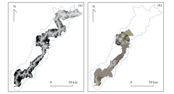
图 1 研究区高分辨率DEM覆盖范围(a)和航空影像覆盖范围(b)
Fig. 1. The high-resolution DEM (a) and aerial image of the study zone (b)

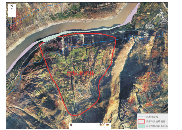
图 2 河漫滩部分的影像以及由此解译出的洪水位线与枯水位线
Fig. 2. The image of wash land and flood level line and low level line interpreted from the image
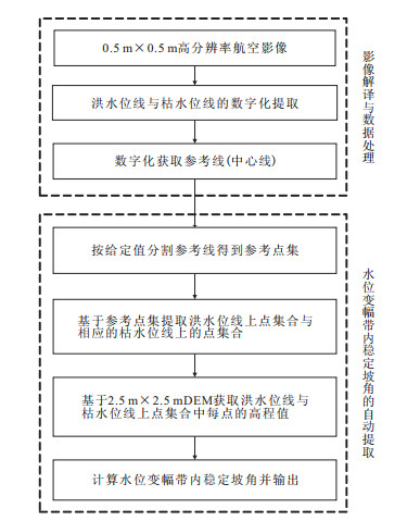
图 3 数据处理与自动提取程序流程
Fig. 3. The process of data manipulating and automated extracting program
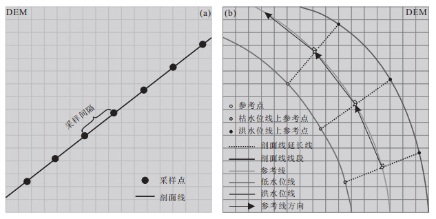
图 4 参考线上等间隔取点示意图(a)和获取洪水位线与枯水位线上点集合示意图(b)
Fig. 4. Picking points from reference line at an equal distance (a) and obtaining point collections from flood level line and low level line (b)
-
He, L.D., Zhu, X.J., 2007. Retrospection and Evaluation of Prediction Method for Reservoir Bank Ruin. Journal of North China Institute of Water Conservancy and Hydroelectric Power, 28(2): 69-72(in Chinese with English abstract). http://d.wanfangdata.com.cn/Periodical/hbslsdxyxb200702022 He, Z.W., Huang, R.Q., Xu, Q., et al., 2004. Design of the Information Management and Prevention about Bank Collapse in the Reservoir Region. Computing Techniques for Geophysical and Geochemical Exploration, 26(4): 341-345(in Chinese with English abstract). http://en.cnki.com.cn/Article_en/CJFDTotal-WTHT200404012.htm Langendoen, E.J., 2000. Concepts-Conservational Channel Evolution and Pollutant Transport System: Stream Corridor Version 1.0(Research Report). USDA-ARS National Sedimentation Laboratory, Mississippi. Langendoen, E.J., Simon, A., Curini, A., et al., 1999. Field Validation of an Improved Process-Based Model for Streambank Stability Analysis. Proceedings of the 1999 International Water Resources Engineering Conference, Reston, Virginia. Lan, X.J., Liu, D.E., Wei, R.J., 2011. GIS Application Development Based on Arc Objects and C#. NET. Metallurgical Industry Press, Beijing (in Chinese with English abstract). Liu, J., Hu, X.W., Wang, J.Q., et al., 2010. Relationship between Underwater Stable Slope Angle and Granularity Composition of Loose Deposit. Advances in Science and Technology of Water Resources, 30(4): 71-75(in Chinese with English abstract). http://www.researchgate.net/publication/284830034_Relationship_between_underwater_stable_slope_angle_and_granularity_composition_of_loose_deposit Ma, S.Z., Jia, H.B., Tang, H.M., 2002. Analogy Method with Stable Side Shape to Predict Reservoir Side Rebuilding of Rock Shore. Earth Science-Journal of China University of Geosciences, 27(2): 231-234 (in Chinese with English abstract). http://en.cnki.com.cn/Article_en/CJFDTOTAL-DQKX200202025.htm Parker, C., Simon, A., Thorne, C.R., 2008. The Effects of Variability in Bank Material Properties on River Bank Stability: Goodwin Creek, Mississippi. Geomorphology, 101(4): 533-543. doi: 10.1016/j.geomorph.2008.02.007 Pollen, N., Simon, A., 2005. Estimating the Mechanical Effects of Riparian Vegetation on Stream Bank Stability Using a Fiber Bundle Model. Water Resources Research, 41(7): 1-13. doi: 10.1029/2004WR003801 Pollen, N., Simon A., Langendoen, E., 2007. Enhancements of a Bank-Stability and Toe-Erosion Model and the Addition of Improved Mechanical Root-Reinforcement Algorithms. World Environmental and Water Resources Congress 2007: Restoring Our Natural Habitate, Tempa, Florida, 1-11. doi: 10.1061/40927(243)348 Que, J.S., 2007. Study on Nonlinear Prediction for Reservoir Bank Collapse in Fuling Area of the Three Gorges Project(Dissertation). Jilin University, Changchun(in Chinese with English abstract). Schilling, K.E., Wolter, C.F., 2000. Application of GPS and GIS to Map Channel Features in Walnut Creek, Iowa. Journal of the American Water Resources Association, 36(6): 1423-1434. doi: 10.1111/j.1752-1688.2000.tb05737.x Simon, A., Collison, A.J.C., 2002. Quantifying the Mechanical and Hydrologic Effects of Riparian Vegetation on Streambank Stability. Earth Surface Processes and Landforms, 27(5): 527-546. doi: 10.1002/esp.325 Tang, M.G., 2007. Research of Forecast Evaluation and Protective Measures of Bank Failure in Mountain Reservoir(Dissertation). Chengdu University of Technology, Chengdu(in Chinese with English Abstract). Tang, Z.H., Zhou, A.G., Cai, H.S., 1999. Prediction of the Riverside Rebuilding in the New Site of Wushan Dowtown, Three Gorges Reservoir Area. Hydrogeology and Engineering Geology, 37(5): 37-39 (in Chinese with English abstract). http://en.cnki.com.cn/Article_en/CJFDTOTAL-SWDG905.011.htm Wang, Y.M., Tang, J.H., Ling, J.M., 2000. Study on Prediction Method for Reservoir Bank Caving. Chinese Journal of Geotechnical Engineering, 22(5): 569-571(in Chinese with English abstract). http://en.cnki.com.cn/Article_en/CJFDTOTAL-YTGC200005012.htm Wood, A.L., Simon, A., Downs, P.W., et al., 2001. Bank-Toe Processes in Incised Channels: The Role of Apparent Cohesion in the Entrainment of Failed Bank Materials. Hydrological Processes, 15(1): 39-61. doi: 10.1002/hyp.151 Xu, C., Dai, F.C., Xu, X.W., 2011. Earthquake Triggered Landslide Susceptibility Evaluation Based on GIS Platform and Weight-of-Evidence Modeling. Earth Science-Journal of China University of GeoSciences, 36(6): 1155-1164 (in Chinese with English abstract). http://www.cnki.com.cn/article/cjfdtotal-dqkx201106022.htm Xu, Q., Huang, R.Q., Tang, M.G., 2009. Research of Bank Failure in Mountain Reservoir. Science Press, Beijing(in Chinese). Xu, Q., Liu, T.X., Tang, M.G., et al., 2007. A New Method of Reservoir Bank Collapse Prediction in the Three Gorges Reservoir-River Bank Structure Method. Hydrogeology & Engineering Geology, (3): 110-115(in Chinese with English abstract). http://search.cnki.net/down/default.aspx?filename=SWDG200703028&dbcode=CJFD&year=2007&dflag=pdfdown Zhang, Z.Y., Wang, S.T., Wang, L.S., et al., 1994. Engineering Geology Analysis Principle. Geology Press, Beijing(in Chinese). 何良德, 朱筱嘉, 2007. 水库塌岸预测方法述评. 华北水利水电学院学报, 28(2): 69-72. doi: 10.3969/j.issn.1002-5634.2007.02.022 何政伟, 黄润秋, 许强, 等, 2004. 库区塌岸空间信息管理系统构建. 物探化探计算技术, 26(4): 341-345. doi: 10.3969/j.issn.1001-1749.2004.04.012 兰小机, 刘德儿, 魏瑞娟, 2011. 基于ArcObjects与C#. NET的GIS应用开发. 北京: 冶金工业出版社. 刘娟, 胡卸文, 王军桥, 等, 2010. 松散堆积体水下稳定坡角与粒度成分的关系. 水利水电科技进展, 30(4): 71-75. https://www.cnki.com.cn/Article/CJFDTOTAL-SLSD201004018.htm 马淑芝, 贾洪彪, 唐辉明, 2002. 利用稳态坡形类比法预测基岩岸坡的库岸再造. 地球科学—中国地质大学学报, 27(2): 231-234. https://www.cnki.com.cn/Article/CJFDTOTAL-DQKX200202025.htm 阙金声, 2007. 三峡工程涪陵区水库塌岸非线性预测研究(博士学位论文). 长春: 吉林大学. 汤明高, 2007. 山区河道型水库塌岸预测评价方法及防治技术研究(博士学位论文). 成都: 成都理工大学. 唐朝晖, 周爱国, 蔡鹤生, 1999. 三峡库区巫山县城新址库岸再造预测. 水文地质工程地质, 37(5): 37-39. https://www.cnki.com.cn/Article/CJFDTOTAL-SWDG905.011.htm 王跃敏, 唐敬华, 凌建明, 2000. 水库坍岸预测方法研究. 岩土工程学报, 22(5): 569-571. doi: 10.3321/j.issn:1000-4548.2000.05.013 许冲, 戴福初, 徐锡伟, 2011. 基于GIS平台与证据权的地震滑坡易发性评价. 地球科学—中国地质大学学报, 36(6): 1155-1164. https://www.cnki.com.cn/Article/CJFDTOTAL-DQKX201106022.htm 许强, 黄润秋, 汤明高, 2009. 山区河道型水库塌岸研究. 北京: 科学出版社. 许强, 刘天翔, 汤明高, 等, 2007. 三峡库区塌岸预测新方法—岸坡结构法. 水文地质工程地质, (3): 110-115. doi: 10.3969/j.issn.1000-3665.2007.03.028 张倬元, 王士天, 王兰生, 等, 1994. 工程地质分析原理. 北京: 地质出版社. -

 下载:
下载:

 点击查看大图
计量
- 文章访问数: 3708
- HTML全文浏览量: 764
- PDF下载量: 448
- 被引次数: 0
