


S-Wave Velocity Structure of Upper Crust in Three Gorges Reservoir Region of the Yangtze River
-
摘要: 为了更好地了解三峡库区的稳定性, 利用三峡库区的流动宽频地震仪台阵于2011年4~5月期间观测的背景噪声数据, 采用互相关方法提取了瑞利面波的格林函数, 用多重滤波方法获得了瑞利面波的群速度频散曲线.利用走时层析成像方法获得了0.5~10.0 s周期的纯路径频散曲线, 进而反演获得了沿巴东-茅坪-土门方向的横波速度结构剖面, 揭示了三峡地区上地壳的速度变化情况.研究表明: (1)研究区地下速度结构与地质构造关系密切, 速度剖面上很好地反映了一个以黄陵背斜核部为中心的背斜构造; (2)九畹溪及其周边区域下方较快的速度变化可能与对应的区域断裂构造、地震活动性密切相关; (3)三斗坪地区上地壳表现为高速, 表明三峡坝区处于构造稳定区域.Abstract: In order to make a better understanding of the stability of the Three Gorges Reservoir region, the profile of S-wave velocity structure along Badong-Maoping-Tumen is presented using the ambient noise data observed at 10 stations from mobile broadband seismic array which is located at Three Gorges Reservoir region. All of available vertical component time series during April and May, 2011 have been cross-correlated to estimate the empirical Green functions. Group velocity dispersion curves were measured by applying multiple filtering technique. Using these dispersion curves, we obtain high resolution pure-path dispersions at 0.5-10 s periods. The S-wave velocity structure, which was reconstructed by inverting the pure-path dispersions, reveals the velocity variations of upper crust at Three Gorges Reservoir region. Main conclusions are as follows. (1)The velocity variations in the study region have a close relationship with the geological structure and the velocity profile suggests an anticline unit which core area is Huangling block. (2)The relative fast velocity variations beneath Jiuwanxi and its surrounding areas may correspond to the geological structure and earthquake activity there. (3) The high velocity of the upper crust in Sandouping indicates that the reservoir dam of Three Gorges is located at a tectonic stable region.
-
Key words:
- S-wave velocity /
- Three Gorges /
- ambient noise /
- reservoir dam stability /
- earthquake
-
金沙江断裂带是青藏高原北部一条重要的断裂带[1, 2], 位于羌塘地体北缘, 其中近东西向的断裂发育, 见有小而零星的蛇绿岩片, 地层大多呈断块状产出, 三叠纪及其以前的地层均不同程度地变质.由于该区处于高寒缺氧的藏北高原腹地无人区, 地层研究不多, 资料很少.西藏地矿局区调大队于1979—1982年间先后对该区的黑熊山、若拉岗日、石渣坡、大横山等处进行了1∶100万路线观察, 根据含晚三叠世双壳Halobia yandongensis的黑熊山东部陷车河南山剖面建立了若拉岗日群, 进而将金沙江断裂带西段的该套巨厚的浅变质岩系统称为若拉岗日群, 时代定为晚三叠世, 此后均沿用这一地层名称[3].我们于1994—1995年到青藏高原北部若拉岗日、石渣坡和大横山一带进行路线地质考察, 在西藏境内金沙江断裂带西段若拉岗日群中首次发现了含晚泥盆世和晚石炭世牙形石化石及相应的地层, 分别命名为晚泥盆世大横山群和晚石炭世石渣坡群, 其中晚泥盆世大横山群(Ddh) 以大横山西侧的晚泥盆世大横山群路线剖面为代表, 岩性为灰色千枚岩与变质粉砂岩互层, 夹黑色薄层泥晶生物灰岩和薄层硅质岩, 厚度大于1 900 m.在灰岩夹层中分离出的牙形石化石, 经成都地质矿产研究所田传荣研究员鉴定有: Palmatolepis sp., Ancyrodella sp., Scutula sp., Polygnathus sp., Nothognathella sp.和Pelekysgnathus sp.等, 其中Palmatolepis是台形牙形石的一种, 分布广泛, 地层时限短, 该属的很多种都是晚泥盆世重要的带化石, 具世界性对比意义; Ancyrodella, Scutula, Nothognathella, Pelekysgnathus也广泛分布于北美、欧洲、澳大利亚和中国南方的晚泥盆世, 因此该群的时代可置于晚泥盆世. 晚石炭世石渣坡群(Csz) 以大横山西侧50 km的晚石炭世石渣坡群路线剖面为代表, 岩性为灰色变质岩屑砂岩、千枚岩、砂板岩、粉砂岩韵律层、夹硅质岩, 底部具小型交错层理, 厚度大于1 500 m, 在灰岩夹层中分离出牙形石化石, 经成都地质矿产研究所田传荣研究员鉴定有: Declinognathodus lateralis (Higgins et Bockaert), D.sp.1, D.sp.2, D.sp.3.Declinognathodus属的很多种都是晚石炭世重要的带化石, 广泛分布于北美、欧洲、亚洲以及我国南方的晚石炭世, 具世界性对比意义, 因此该套地层的时代应为晚石炭世.
该套地层及牙形石的发现具以下地质意义: (1) 确立了金沙江断裂带西段最古老的地层记录.前人曾在西藏宁共曲久隆和狮头山附近采获早二叠世菊石Stacheoceras cf.mirificum Liu和

-
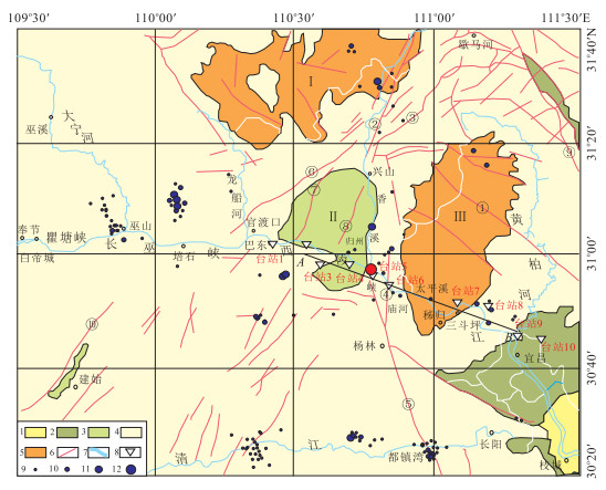
图 1 三峡地区地质构造和地震台站分布(据李强等,2011修改)
①雾渡河断裂;②新华断裂;③兴山-马良平断裂;④九畹溪断裂;⑤仙女山断裂;⑥高桥断裂;⑦牛口断裂;⑧水田坝断裂;⑨远安断裂带;⑩建始断裂;B11天阳坪断裂;Ⅰ.神农架地块;Ⅱ.秭归盆地;Ⅲ.黄陵背斜;1.第四系;2.白垩系-第三系;3.侏罗系;4.三叠系-震旦系;5.前震旦系;6.断裂;7.河流;8.宽频地震台站,台站旁边标注了台站编号(表 1);9~12为三峡大坝蓄水前两年半(2001年1月到2003年6月)震级分别为Ms0~0.9、1.0~1.9、2.0~2.0和大于3.0的地震震中位置.图中黑色实线为图 7中横波速度剖面所在位置.红色实心圆圈为秭归2014年3月27日Ms4.3级和3月30日Ms4.7地震震中的位置
Fig. 1. Three Gorges Region and distribution of broadband seismic stations
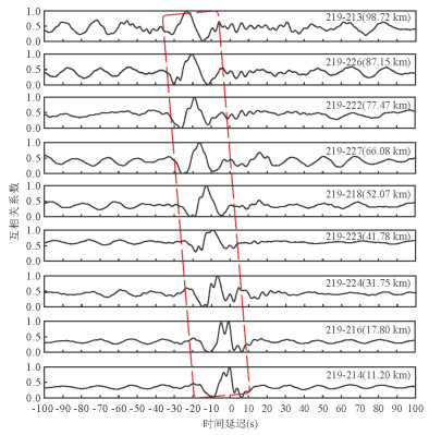
图 2 部分台站地震记录垂向分量的互相关结果
图中对纵坐标对应的互相关结果进行了归一化处理,图的右上角标注了进行互相关的台站对及相应的台站间距
Fig. 2. An example of cross-correlation record
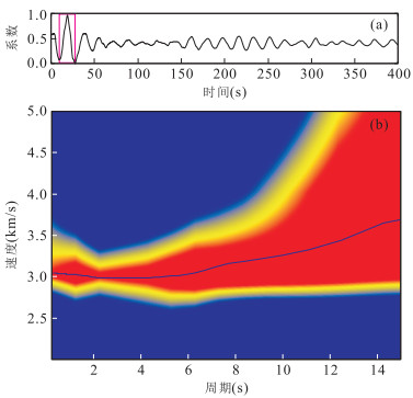
图 3 利用多重滤波方法进行瑞利面波群速度频散曲线提取
a.台站9和台站3的互相关波形记录,站台9和站台3,距离=69.46 km,时间=27 d,信噪比=16.39;b.群速度频散时频图,蓝线代表提取的频散曲线
Fig. 3. An example of dispersion measurement using multiple filter method
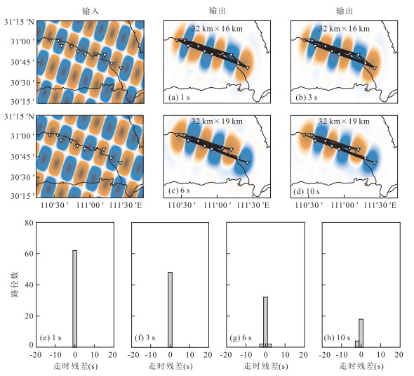
图 4 不同周期的分辨率测试结果(a~d)及层析成像走时残差(e~h)
图a~图f中“△”为宽频地震台站,黑色实线为射线路径
Fig. 4. Resolution results (a~d) and travel time misfits (e~h) maps at different periods

图 5 1 s、3 s、6 s、10 s周期的群速度
图中“▽”代表台站,黑色粗线为图 7中横波速度剖面所在位置
Fig. 5. Group velocity maps at periods of 1(a), 3(b), 6(c) and 10(d) seconds
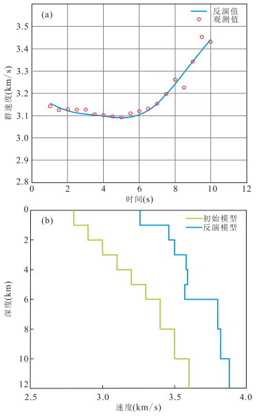
图 6 三峡地区纯路径频散曲线的一维速度结构反演
a.实测频散曲线和反演频散曲线拟合情况;b.反演获得的横波速度结构
Fig. 6. One dimensional velocity structure inversion of the pure path dispersion curves in Three Gorges Region
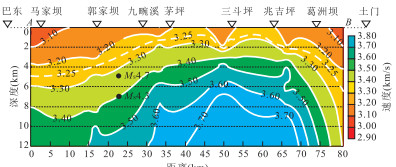
图 7 巴东-茅坪-土门一线横波速度结构剖面
右边色柱标志横波速度.“▽”为研究所使用宽频地震台站在剖面上的投影,上方标注了台站的位置.白色虚线为低速区的底界面.“ ●”为秭归2014年3月27日Ms4.3和3月30日Ms4.7地震震中的位置
Fig. 7. The S-wave velocity profile along Badong, Maoping and Tumen
表 1 宽频地震仪布置情况
Table 1. Location of broadband seismographs
台站编号 仪器编号 坐标经纬度 高程(m) 观测时间(年月日) 台站位置 1 219 110.44°E,31.02°N 414 20110422—20110519 巴东 2 214 110.55°E,31.01°N 276 20110422—20110517 秭归台子湾 3 216 110.60°E,30.95°N 172 20110422—20110520 秭归马家坝 4 224 110.74°E,30.94°N 159 20110421—20110513 郭家坝 5 223 110.83°E,30.88°N 378 20110421—20110520 九畹溪 6 218 110.93°E,30.85°N 411 20110421—20110521 茅坪 7 227 111.08°E,30.85°N 120 20110424—20110521 三斗坪 8 222 111.20°E,30.84°N 599 20110424—20110522 兆吉坪 9 226 111.30°E,30.73°N 120 20110420—20110521 葛洲坝 10 213 111.43°E,30.68°N 69 20110420—20110518 土门  下载: 导出CSV
-
Bensen, G.D., Ritzwoller, M.H., Barmin, M.P., et al., 2007. Processing Seismic Ambient Noise Data to Obtain Reliable Broad-Band Surface Wave Dispersion Measurements. Geophysical Journal International, 169(3): 1239-1260. doi: 10.1111/j.1365-246X.2007.03374.x Chen, B.Y., Gao, W.H., 1986. A Preliminary Investigation for Crustal Velocity-Layer Structure Using Explosion Seismic Profile from the Jiajiawan to the Shayuan, Hubei. Crustal Deformation and Earthquake, 6(1): 65-74(in Chinese with English abstract). http://en.cnki.com.cn/Article_en/CJFDTOTAL-DKXB198601011.htm Chen, X.B., 1994. Characteristics of Deep Structure of Three Gorges and Its Adjacent Area. Seismological Press, Beijing, 50-63 (in Chinese). Fang, L.H., Wu, J.P., Lü, Z.Y., 2009. Rayleigh Wave Group Velocity Tomography from Ambient Seismic Noise in North China. Chinese Journal of Geophysics, 52(3): 663-671 (in Chinese with English abstract). doi: 10.1002/cjg2.1388 Gardner, G.H., Gardner, L.W., Greory, A.R., 1974. Formation Velocity and Density: The Diagnostic Basics for Stratigraphic Traps. Geophysics, 39(6): 770-780. doi: 10.1190/1.1440465 Kennett, B.L.N., Sambridge, M.S., Williamson, P.R., 1988. Subspace Methods for Large Inverse Problems with Multiple Parameter Classes. Geophysics, 94(2): 237-247. doi: 10.1111/j.1365-246X.1988.tb05898.x Li, H.Y., Bernardi, F., Michelini, A., 2010. Surface Wave Dispersion Measurements from Ambient Seismic Noise Analysis in Italy. Geophysical Journal International, 180(3): 1242-1252. doi: 10.1111/j.1365-246X.2009.04476.x Li, Q., Zhao, X., Cai, J.A., et al., 2009. P-wave Velocity Structure of Upper and Middle Crust beneath the Three Gorges Reservoir Dam and Adjacent Region. Science in China (Ser. D), 39(4): 427-436 (in Chinese). http://www.wanfangdata.com.cn/details/detail.do?_type=perio&id=zgkx-ed200904015 Li, Q., Zhao, X., Cai, J.A., et al., 2011. S-Wave Velocity Structure of Upper and Middle Crust beneath the Three Gorges Reservoir Dam and Adjacent Region. Acta Seismologica Sinica, 33(1): 39-50 (in Chinese with English abstract). http://en.cnki.com.cn/Article_en/CJFDTOTAL-DZXB201101005.htm Li, T.L., 1991. Evaluation of the Regional Crust Stability in the Three Gorge Areas of the Yangtze River. Journal of Xi'an College of Geology, 13(3): 48-58 (in Chinese with English abstract). http://www.en.cnki.com.cn/Article_en/CJFDTOTAL-XAGX199103007.htm Liao, W., L., Yao, Y.S., Ding, Z.F., et al., 2007. Tomographic Imagery of P Wave Velocity Structure in Three Gorges Region. Journal of Geodesy and Geodynamics, 27(3): 80-84(in Chinese with English abstract). http://www.oalib.com/paper/1552823 Lin, F.Q., Ritzwoller, M.H., Townend. J., et al., 2007. Ambient Noise Rayleigh Wave Tomography of New Zealand. Geophysical Journal International, 170(2): 649-666. doi: 10.1111/j.1246X.2007.03414.x Liu, C.Z., Tan, Z.D., 1989. Study on Earthquake Induced Environment and Engineering Geology in Three Gorges Region. Earthquake Proceedings on Three Gorges Project. Science Press, Beijing, 427-442 (in Chinese). Liu, S.F., Liu, S.W., Jia, M.Y., et al., 1984. The Deep Gravitational Field and Its Geological Explanation over Hubei Province and Vicinal Regions. Crustal Deformation and Earthquake, 4(4): 357-364(in Chinese with English abstract). http://en.cnki.com.cn/Article_en/CJFDTOTAL-DKXB198404006.htm Ma, Z.J., 1964. Mechanics Analysis of Mesozoic Geological Structure in the West of Hubei Province. Scientia Geological Sinica, (1): 76-90(in Chinese). Mei, B., Xu, Y., Zhang, Y., 2013. P- and S-Velocity Structure beneath the Three Gorges Region(Central China) from Local Earthquake Tomography. Geophysical Journal International, 193(2): 1035-1049. doi: 10.1093/gji/ggt047 Peng, S.B., Li, C.N., Kusky, T.M., et al., 2010. Discovery and Its Tectonic Significance of the Proterozoic Miaowan Ophiolites in the Southern Huangling Anticline, Western Hubei, China. Geological Bulletin of China, 29(1): 8-20 (in Chinese with English abstract). http://www.researchgate.net/publication/287557049_Discovery_and_its_tectonic_significance_of_the_Proterozoic_Miaowan_ophiolites_in_the_southern_Huangling_anticline_western_Hubei_China Rawlinson, N., Sambridge, M., 2005. The Fast Marching Method: An Effective Tool for Tomographic Imaging and Tracking Multiple Phases in Complex Layered Media. Exploration Geophysics, 36(4): 341-350. doi: 10.1071/EG05341 Tan, Z.D., Bo, J.S., 1991. Assessment of Crustal Stability and Predictions of Reservoir-Induced Earthquake in Reservoir Head Region of Three Gorges Project on Yangtze River. Geological Publishing House, Beijing, 10-21(in Chinese). Wang, S.R., Zhu, S.L., Li, R.C., 1992. Three Dimensional Inversion of Gravity Anomalies in the Region of Three Gorges, the Yangtze River. Acta Geophysica Sinica, 35(1): 69-76(in Chinese with English abstract). http://en.cnki.com.cn/Article_en/CJFDTotal-DQWX199201009.htm Xia, H.K., Lu, Z.X., Niu, X., et al., 1992. The Seismic (Active) Area's Deep and Shallow Tectonic, Composition and Its Relationship with Earthquakes in Chaoyang-Yixian. Acta Seismologica Sinica, 14(2): 180-186 (in Chinese). doi: 10.1007/BF02651024/metrics Xia, J.H., Miller, R.D., Park, C.B., 1999. Estimation of Near-Surface Shear-Wave Velocity by Inversion of Rayleigh Wave. Geophysics, 64(3): 691-700. doi: 10.1190/1.1444578 Yan, Z.G., Xue, J.R., 1988. Study of Regional Crust Structure by Imaginary Wave Velocity in Three Gorges Regiona of Yangtze River. South China Seismological Journal, 8(3): 1-8(in Chinese with English abstract). http://en.cnki.com.cn/Article_en/CJFDTOTAL-HNDI198803000.htm Yang, Y.J., Ritzwoller, M.H., Levshin, A.L., 2007. Ambient Noise Rayleigh Wave Tomography across Europe. Geophysical Journal International, 168(1): 259-274. doi: 10.1111/j.1365-246X.2006.03203.x Yuan, D.W., Mei, Y.T., Qin, X.L., et al., 1996. Crustal Stability Study in and around the Dam Region of Three Gorges Project. China University of Geosciences Press, Wuhan, 11-17(in Chinese). Zhang, Z.J., Bai, Z.M., Walter, M., et al., 2009. Crustal Structure across the Three Gorges Area of Yangtze Platform, Central, from Seismic Refraction/Wide-Angle Reflection Data. Tectonophysics, 475(3-4): 423-437. doi: 10.1016/j.tecto.2009.05.022 Zhang, Y., Chen, C., Liang, Q., et al., 2012. Density Structure of Upper and Middle Crust in Three Gorges Reservoir Area. Earth Science—Journal of China University of Geosciences, 37(Suppl. ): 213-222 (in Chinese with English abstract). http://en.cnki.com.cn/Article_en/CJFDTOTAL-DQKX2012S1024.htm Zhang, Z.F., 1996. Crust Deformation Monitoring and Analysis of Crust Stability in the Yangtze Gorges Area. Crustal Deformation and Earthquake, 16(4): 48-53 (in Chinese with English abstract). http://en.cnki.com.cn/Article_en/CJFDTOTAL-DKXB604.008.htm Zhou, Q.Y., He, Y.F., Jin, P., et al., 2006. Using MFT Obtain Rayleigh-Wave Dispersion Curve. Northwestern Seismological Journal, 28(1): 46-50 (in Chinese with English abstract). http://en.cnki.com.cn/Article_en/CJFDTotal-ZBDZ200601009.htm Zhu, J.S., 1988. The Calculation Method in Seismology. Seismological Press, Beijing, 473-476(in Chinese). 陈步云, 高文海, 1986. 贾家湾-沙园剖面地壳结构的初步研究. 地壳形变与地震, 6(1): 65-74. https://www.cnki.com.cn/Article/CJFDTOTAL-DKXB198601011.htm 陈学波, 1994. 长江三峡工程坝区及外围深部构造特征研究. 北京: 地震出版社, 50-63. 房立华, 吴建平, 吕作勇, 2009. 华北地区基于噪声的瑞利面波群速度层析成像. 地球物理学报, 52(3): 663-671. https://www.cnki.com.cn/Article/CJFDTOTAL-DQWX200903010.htm 李强, 赵旭, 蔡晋安, 等, 2009. 三峡水库坝址及邻区中上地壳P波速度结构. 中国科学, 39(4): 427-436. https://www.cnki.com.cn/Article/CJFDTOTAL-JDXK200904005.htm 李强, 赵旭, 蔡晋安, 等, 2011. 三峡水库坝址及邻区中上地壳S波速度结构. 地震学报, 33(1): 39-50. doi: 10.3969/j.issn.0253-3782.2011.01.004 李同录, 1991. 长江三峡地区区域地壳稳定性评价. 西安地质学院学报, 13(3): 48-58. https://www.cnki.com.cn/Article/CJFDTOTAL-XAGX199103007.htm 廖武林, 姚运生, 丁志峰, 等, 2007. 三峡地区P波速度层析成像研究. 大地测量与地球动力学, 27(3): 80-84. https://www.cnki.com.cn/Article/CJFDTOTAL-DKXB200703018.htm 刘传正, 谭周地, 1989. 长江三峡库首区诱发地震的环境工程地质研究. 长江三峡工程地震专题论文集. 北京: 科学出版社, 427-442. 刘绍府, 刘锁旺, 贾民育, 1984. 湖北和邻区深部重力场及其地质解释. 地壳变形与地震, 4(4): 357-364. https://www.cnki.com.cn/Article/CJFDTOTAL-DKXB198404006.htm 马宗晋, 1964. 鄂西中生代地质构造的力学分析. 地质科学, (1): 76-90. 彭松柏, 李昌年, Kusky, T.M., 等, 2010. 鄂西黄陵背斜南部元古宙庙湾蛇绿岩的发现及其构造意义. 地质通报, 29(1): 8-20. doi: 10.3969/j.issn.1671-2552.2010.01.002 谭周地, 薄景山, 1991. 长江三峡工程库首区地壳稳定性评价与水库诱发地震预测. 北京: 地质出版社, 10-21. 王石任, 朱思林, 李蓉川, 1992. 长江三峡地区三维重力反演研究. 地球物理学报, 35(1): 69-76. doi: 10.3321/j.issn:0001-5733.1992.01.009 夏怀宽, 卢造勋, 刘雪等, 1992. 朝阳—义县地震区的深浅部构造、组成及其与地震的关系. 地震学报, 14(2): 180-186. https://www.cnki.com.cn/Article/CJFDTOTAL-DZXB199202007.htm 严尊国, 薛军蓉, 1988. 利用虚波速度研究长江三峡地区地壳结构. 华南地震, 8(3): 1-8. https://www.cnki.com.cn/Article/CJFDTOTAL-HNDI198803000.htm 袁登维, 梅应堂, 秦兴黎, 等, 1996. 长江三峡工程坝区及外围地壳稳定性研究. 武汉: 中国地质大学出版社, 11-17. 张毅, 陈超, 梁青, 等, 2012. 三峡地区中上地壳密度结构. 地球科学—中国地质大学学报, 37(增刊1): 213-222. https://www.cnki.com.cn/Article/CJFDTOTAL-DQKX2012S1024.htm 张众服, 1996. 三峡地区地形变监测与区域地壳稳定性分析. 地壳形变与地震, 16(4): 48-53. https://www.cnki.com.cn/Article/CJFDTOTAL-DKXB604.008.htm 周青云, 何永峰, 靳平, 等, 2006. 利用多重滤波方法提取面波频散曲线. 西北地震学报, 28(1): 46-50. https://www.cnki.com.cn/Article/CJFDTOTAL-ZBDZ200601009.htm 朱介寿, 1988. 地震学中的计算方法. 北京: 地震出版社, 473-476. -

 点击查看大图
计量
- 文章访问数: 3783
- HTML全文浏览量: 569
- PDF下载量: 449
- 被引次数: 0
