


Three-Dimensional Geological Mapping and Visualization of Complex Orogenic Belts
-
摘要: 三维地质填图是一项探索性很强的开拓性工作,目前尚无成熟经验可循.对于地球物理和钻探资料相对有限的复杂造山带成矿带地区,区域性的三维地质结构的揭示更具挑战性.结合西准噶尔克拉玛依后山地区三维地质填图实践,提出造山带基岩三维地质填图的基本思路,对具有一定幅面一定比例尺的区域三维地质填图与建模的方法技术进行了总结,提出针对造山带区域的“基于地表地质调查剖面网络基础上的地质-地球物理-钻孔联合约束的三维地质调查方法体系”,探索实践“基于地表地质调查剖面网络基础上的三维地质建模技术方法”,强调建模的数据基础来自地表基础地质调查的系统路线剖面和实测剖面,即以地表实测地质路线为基础结合地球物理和钻探资料向下合理延拓,从而实现“区域三维地质填图”概念上的三维地质结构的数字表达.
-
关键词:
- 造山带 /
- 三维地质调查与建模方法 /
- 地表地质调查 /
- 地质-地球物理-钻孔联合约束
Abstract: Three-dimensional geological mapping is a pioneering job in frontiers without much experience. It is far more challenging to work out three-dimensional geological structure in a square area with certain scale for complex orogenic and metallogenic belts, where geophysical and drilling data are relatively limited. In this paper, we put forward a framework of the three-dimensional geological mapping and visualization for bedrocks of orogenic belts based on our three-dimensional geological mapping practice in the northwest Karamay, western Junggar. We emphasize that the basic data involved in visual modeling for a certain square area and scale are primarily based on the network of systematic surface geological sections and then the extension for the deep geological bodies which are based on geological-geophysical-drilling united constraints. With the combination of surface geological sections and geophysical/drilling data, three-climension geological texture from surface to certain depths at a certain confidence level can be traced. That is to say that three-dimensional numerical models of geological structures can be constructed by utilizing the rich data of classical "surface regional geological mapping" with the combination of geophysical/drilling data. -
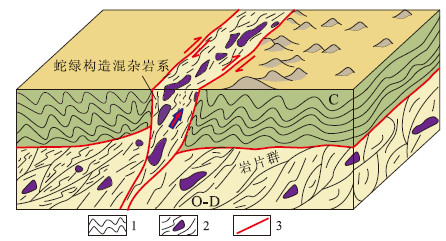
图 1 西准噶尔克拉玛依后山地区石炭系下伏基底及蛇绿混杂岩系右旋楔入概念模型
1.褶皱变形的石炭纪残留海盆浊积岩系;2.奥陶纪-泥盆纪蛇绿构造混杂岩系,紫色团块示残留大洋岩石圈地幔超镁铁岩岩块;3.断层
Fig. 1. Conceptual model of the underlying basement of Carboniferous and the right lateral wedge-thrusting pattern of the ophiolitic melange in the north mountain areas of the Karamay, western Junggar
图 2 白碱滩一带(1∶100 000白碱滩幅基岩区)近地表地质剖面网络格架
Fig. 2. Network of near surface geological sections in Baijiantan bedrock areas of 1∶100 000 Baijiantan map sheet
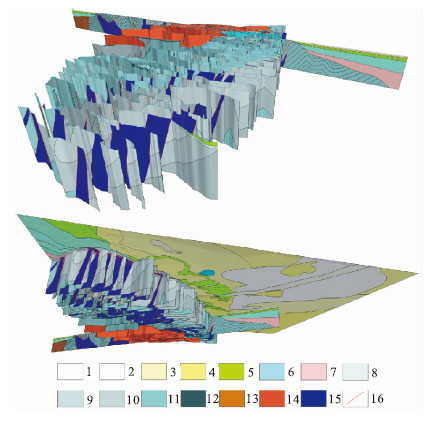
图 3 白碱滩一带(1∶100 000白碱滩幅基岩区)插入1号线地质-地球物理综合解释剖面的三维地质结构剖面网络格架
1.全新统冲积(Qhal);2.上更新统-全新统冲积(Qp3-hpl+ch);3.上更新统-全新统冲洪积(Qp3-halp)4.上更新统洪积(Qp3pl);5.下白垩统吐古鲁群(K1T);6.侏罗系;7.上三叠统小泉沟群(T3x);8.下石炭统太勒古拉组c段(C1tc);9.下石炭统太勒古拉组b段(C1tb);10.下石炭统太勒古拉组a段(C1ta);11.下石炭统包古图组(C1b);12.下石炭统希贝库拉斯组(C1xb);13.泥盆系;14.晚石炭世红山花岗岩体(γHSC2);15.蛇绿混杂岩系;16.断层
Fig. 3. Network of three-dimensional geological structure profile which inserts No.1 geological-geophysical comprehensive interpretation section in Baijiantan bedrock areas of 1∶100 000 Baijiantan map sheet

图 4 白碱滩盆山结合部三维地质结构初步模型
1.上更新统洪积(Qp3pl);2.下白垩统吐古鲁群(K1T);3.下石炭统太勒古拉组c段(C1tc);4.下石炭统太勒古拉组b段(C1tb);5.下石炭统太勒古拉组a段(C1ta);6.下石炭统包古图组(C1b);7.下石炭统希贝库拉斯组(C1xb);8.蛇绿混杂岩系;9.断层
Fig. 4. A preliminary model of 3D geological structure in the basin-range junction area of Baijiantan
表 1 深部地质信息约束条件分级评价标准
Table 1. Evaluation criteria for the deep geological information constraint classification
约束条件 高 较高 中 较低 地表地质信息 与地表地质观测资料有直接联系,地表观测资料详实可靠 有正确的理论或概念模型为依据,与地表地质信息关联性较好 有一定的理论或概念模型为依据,与地表地质信息有一定关联,但存在一定的不确定性 理论或概念模型不确定,地表地质信息与深部关联性不确定,推测性大 地球物理信息 有地球物理勘探结果约束 有可借鉴的地球物理探测资料 有可借鉴的地球物理探测资料,但推测性较大 与地球物理信息关联较弱 钻孔约束 有钻孔控制 有钻孔资料借鉴  下载: 导出CSV
-
Chen, C., Chen, G.F., 2012. Application and Research of Three Dimensional Modeling in District Geologic Survey. City Geology, 7(1): 20-25 (in Chinese with English abstract). http://en.cnki.com.cn/Article_en/CJFDTOTAL-CSDZ201201008.htm Courrioux, G., Nullans, S., Guillen, A., et al., 2001.3D Volumetric Modelling of Cadomian Terranes (Northern Brittany, France): An Automatic Method Using Vorono Diagrams. Tectonophysics, 331(1-2): 181-196. doi: 10.1016/S0040-1951(00)00242-0 Cui, T.Z., Ma, X.P., 2010. An Application of 3D Structural Modeling to Complex Fault-Block Reservoirs—A Case of the Lower Unit Reservoir of Sha-3 Member in Block Wei-95, Mazhai Oilfield, Dongpu Depression. Oil & Gas Geology, 31(2): 198-205 (in Chinese with English abstract). http://en.cnki.com.cn/Article_en/CJFDTOTAL-SYYT201002013.htm Dong, S.W., Li, T.D., Gao, R., et al., 2010. International Progress in Probing the Earth's Lithosphere and Deep Interior: A Review. Acta Geologica Sinica, 84(6): 743-770 (in Chinese with English abstract). http://en.cnki.com.cn/Article_en/CJFDTOTAL-DZXE201006003.htm Guan, S.W., Li, B.L., Hou, L.H., et al., 2008. New Hydrocarbon Exploration Areas in Footwall Covered Structures in Northwestern Margin of Junggar Basin. Petroleum Exploration and Development, 35(1): 17-22 (in Chinese with English abstract). doi: 10.1016/S1876-3804(08)60004-X Guiziou, J.L., Mallet, J.L., Madariaga, R., 1996.3-D Seismic Reflection Tomography on Top of the Gocad Depth Modeler. Geophysics, 61(5): 1499-1510. doi: 10.1190/1.1444075 He, D.F., Yin, C., Du, S.K., et al., 2004. Characteristics of Structural Segmentation of Foreland Thrust Belts—A Case Study of the Fault Belts in the Northwestern Margin of Junggar Basin. Earth Science Frontiers, 11(3): 91-101 (in Chinese with English abstract). Jachens, R.C., Wentworth, C.M., Gautier, D.L., et al., 2001.3D Geologic Maps and Visualization: A New Approach to the Geology of the Santa Clara (Silicon) Valley, California. Digital Mapping Techniques '01, U.S. Geological Survey Open-File Report 1-223, 13-23. Li, C.L., Yu, Q.W., Yang, D.L., et al., 2003. Research on PRB Digital Mapping Techniques. Earth Science—Journal of China University of Geosciences, 28(4): 377-383 (in Chinese with English abstract). http://www.cnki.com.cn/Article/CJFDTotal-DQKX200304002.htm Li, L.P., Hu, F.S., Yin, L.H., 2007. On the 3-Dimensional Geological Modeling of Cretaceous System in the Ordos Basin. Northwestern Geology, 40(2): 109-113 (in Chinese with English abstract). http://www.researchgate.net/publication/298473755_On_the_3-dimentional_geological_modeling_of_Cretaceous_system_in_the_Ordos_Basin Li, S., Li, W.B., Song, S.P., 2008. Applied Research of the Three-Dimensional Geological Model Building. Science Technology and Engineering, 8(24): 6584-6590 (in Chinese with English abstract). http://www.en.cnki.com.cn/Article_en/CJFDTOTAL-KXJS200824031.htm Luo, Z.Y., Yang, W.N., 2008.3D Modeling and Visualization of Geological Bodies Based on Borehole Data. Science of Surveying and Mapping, 33(2): 130-132 (in Chinese with English abstract). http://d.wanfangdata.com.cn/Periodical_chkx200802045.aspx Lü, P., Zhang, W., Liu, G., et al., 2013. Three-Dimensional Geological Mapping Progress of Important abroad Institution of Geological Survey. Land and Resources Information, (3): 13-18 (in Chinese). Malolepszy, Z., 2005. Three-Dimensional Geological Maps. In: Ostaficzuk, S.R., ed., The Current Role of Geological Mapping in Geosciences. NATO Science Series, 56: 215-224. Mao, X.C., Zou, Y.H., Chen, J., et al., 2010. Three-Dimensional Visual Prediction of Concealed Ore Bodies in the Deep and Marginal Parts of Crisis Mines: A Case Study of the Fenghuangshan Orefield in Tongling. Anhui, China. Geological Bulletin of China, 29(2-3): 401-413 (in Chinese with English abstract). http://www.zhangqiaokeyan.com/academic-journal-cn_geological-bulletin-china_thesis/0201252285001.html Pan, M., Fang, Y., Qu, H.G., 2007. Discussion on Several Foundational Issues in Three-Dimensional Geological Modeling. Geography and Geo-Information Science, 23(3): 1-5 (in Chinese with English abstract). http://www.researchgate.net/publication/291050448_Discussion_on_several_foundational_issues_in_three-dimensional_geological_modeling Shang, J.G., Liu, X.G., 2006. Study on 3D Space Information System of Domain Specific Urban Geology. Journal of Huazhong University of Science and Technology (Urban Science Edition), 23(Suppl. 1): 172-175 (in Chinese with English abstract). http://www.en.cnki.com.cn/Article_en/CJFDTOTAL-WHCJ2006S1050.htm Shao, Y.L., He, Y.B., Xu, X.H., 2012. Structural Modeling under Complicated Geological Features—by Taking Dalinghe Oil Formation in Shu Ⅱ District as an Example. Journal of Oil and Gas Technology, 34(2): 50-52 (in Chinese with English abstract). http://en.cnki.com.cn/Article_en/CJFDTOTAL-JHSX201202009.htm Shen, P., Shen, Y.C., Liu, T.B., et al., 2009. Geochemical Signature of Porphyries in the Baogutu Porphyry Copper Belt, Western Junggar, NW China. Gondwana Research, 16: 227-242. doi: 10.1016/j.gr.2009.04.004 Turner, A.K., 1992. Three-Dimensional Modeling with Geoscientific Information Systems. Springer, New York, 443. Wang, M.H., Bai Y., 2006. The Status Quo and Development Tendency of 3D Geosciences Modeling. Soil Engineering and Foundation, 20(4): 68-70 (in Chinese with English abstract). http://en.cnki.com.cn/Article_en/CJFDTOTAL-TGJC200604019.htm Wu, J., Cao, D.Y., Deng, A.J., et al., 2005.3D Geological Modeling on Studying Oilfield Geology. Journal of Earth Sciences and Environment, 27(2): 52-55 (in Chinese with English abstract). Wu, L.X., Shi, W.Z., 2005. On Three Dimensional Geosciences Spatial Modeling. Geography and Geo-Information Science, 21(1): 1-4 (in Chinese with English abstract). http://en.cnki.com.cn/Article_en/CJFDTOTAL-DLGT200501001.htm Yu, J.J., Wang, G.C., Xu, Y.X., et al., 2015. Constraining Deep Geological Structures in the Three-Dimensional Geological Mapping of Complicated Orogenic Belts: A Case Study from the Karamay Region, Western Junggar. Earth Science—Journal of China University of Geosciences, 40(3): 407-418 (in Chinese with English abstract). doi: 10.3799/dqkx.2015.032 Zhang, B.Y., Shang, J.G., Wu, H.M., et al., 2007. Application of 3D Geological Modeling and Visualization in Solid Mineral Resource Estimation. Geology and Prospecting, 43(2): 76-81 (in Chinese with English abstract). http://en.cnki.com.cn/Article_en/CJFDTOTAL-DZKT200702016.htm Zhang, L., Wang, G.C., Gao, R., et al., 2015. U-Pb Chronology of Carboniferous Detrital Zircons and Its Geological Implications in West Junggar. Geotectonica et Metallogenia, in press (in Chinese with English abstract). Zhang, S.K., Ni, J.Y., Gao, W.L., et al., 2009. Study on the Technology and Method of 3D Geological Modeling: A Case Study of the East Kunlun Orogenic Belt. Journal of Geomechanics, 15(2): 201-208 (in Chinese with English abstract). http://www.researchgate.net/publication/285768440_Study_on_the_technology_and_method_of_3d_geological_modeling_A_case_study_of_the_east_kunlun_orogenic_belt Zhang, Y.Q., Wang, X., Liu, J.S., et al., 2011. Wuerhe-Xiazijie Strike-Slip Structure and Petroleum Exploration Significance in Northwestern Margin of Junggar Basin. Xinjiang Petroleum Geology, 32(5): 447-450 (in Chinese with English abstract). http://en.cnki.com.cn/Article_en/CJFDTOTAL-XJSD201105003.htm Zhu, L.F., Wu, X.C., Liu, X.G., 2004. Preliminary Study of 3D Urban Geological Information System. Geography and Geo-Information Science, 20(5): 36-40 (in Chinese with English abstract). http://en.cnki.com.cn/Article_en/CJFDTOTAL-DLGT200405009.htm Zhu, Q., 2004. A Survey of Three Dimensional GIS Technologies. Geomatics World, 2(3): 8-12 (in Chinese with English abstract). Zong, R.W., Gong, Y.M., Wang, G.C., 2014. Carboniferous Stratal Sequence and Its Palaeogeographical Evolution in Southwestern Junggar, NW China. Earth Science Frontiers, 21(2): 216-233 (in Chinese with English abstract). http://www.cnki.com.cn/Article/CJFDTotal-DXQY201402018.htm 陈超, 陈广峰, 2012. 三维建模技术在区域工程地质勘查中的应用研究. 城市地质, 7(1): 20-25. https://www.cnki.com.cn/Article/CJFDTOTAL-CSDZ201201008.htm 崔廷主, 马学萍, 2010. 三维构造建模在复杂断块油藏中的应用——以东濮凹陷马寨油田卫95块油藏为例. 石油与天然气地质, 31(2): 198-205. https://www.cnki.com.cn/Article/CJFDTOTAL-SYYT201002013.htm 董树文, 李廷栋, 高锐, 等, 2010. 地球深部探测国际发展与我国现状综述. 地质学报, 84(6): 743-770. https://www.cnki.com.cn/Article/CJFDTOTAL-DZXE201006003.htm 管树巍, 李本亮, 侯连华, 等, 2008. 准噶尔盆地西北缘下盘掩伏构造油气勘探新领域. 石油勘探与开发, 35(1): 17-22. https://www.cnki.com.cn/Article/CJFDTOTAL-SKYK200801007.htm 何登发, 尹成, 杜社宽, 2004. 前陆冲断带构造分段特征——以准噶尔盆地西北缘断裂构造带为例. 地学前缘, 11(3): 91-101. doi: 10.3321/j.issn:1005-2321.2004.03.011 李超岭, 于庆文, 杨东来, 等, 2003. PRB数字地质填图技术研究. 地球科学——中国地质大学学报, 28(4): 377-383. https://cdmd.cnki.com.cn/Article/CDMD-10270-1014337614.htm 李良平, 胡伏生, 尹立河, 2007. 鄂尔多斯盆地白垩系三维地质建模研究. 西北地质, 40(2): 109-113. https://www.cnki.com.cn/Article/CJFDTOTAL-XBDI200702010.htm 李舒, 李伟波, 宋世鹏, 2008. 三维地质建模的应用研究. 科学技术与工程, 8(24): 6584-6590. doi: 10.3969/j.issn.1671-1815.2008.24.031 罗智勇, 杨武年, 2008. 基于钻孔数据的三维地质建模与可视化研究. 测绘科学, 33(2): 130-132. doi: 10.3771/j.issn.1009-2307.2008.02.045 吕鹏, 张炜, 刘国, 等, 2013. 国外重要地质调查机构三维地质填图工作进展. 国土资源情报, (3): 13-18. doi: 10.3969/j.issn.1674-3709.2013.03.003 毛先成, 邹艳红, 陈进, 等, 2010. 危机矿山深部、边部隐伏矿体的三维可视化预测——以安徽铜陵凤凰山矿田为例. 地质通报, 29(2-3): 401-413. https://www.cnki.com.cn/Article/CJFDTOTAL-ZQYD2010Z1028.htm 潘懋, 方裕, 屈红刚, 2007. 三维地质建模若干基本问题探讨. 地理与地理信息科学, 23(3): 1-5. https://www.cnki.com.cn/Article/CJFDTOTAL-DLGT200703000.htm 尚建嘎, 刘修国, 2006. 城市地质领域三维空间信息系统的开发研究. 华中科技大学学报(城市科学版), 23(增刊1): 172-175. https://www.cnki.com.cn/Article/CJFDTOTAL-WHCJ2006S1050.htm 邵燕林, 何幼斌, 许晓宏, 2012. 复杂地质特征下的构造建模——以辽河油田曙二区大凌河油层为例. 石油天然气学报, 34(2): 50-52. https://www.cnki.com.cn/Article/CJFDTOTAL-JHSX201202009.htm 王明华, 白云, 2006. 三维地质建模研究现状与发展趋势. 土工基础, 20(4): 68-70. https://www.cnki.com.cn/Article/CJFDTOTAL-TGJC200604019.htm 吴键, 曹代勇, 邓爱居, 等, 2005. 三维地质建模技术在油田基础地质研究中的应用. 地球科学与环境学报, 27(2): 52-55. https://www.cnki.com.cn/Article/CJFDTOTAL-XAGX200502013.htm 吴立新, 史文中, 2005. 论三维地学空间构模. 地理与地理信息科学, 21(1): 1-4. https://www.cnki.com.cn/Article/CJFDTOTAL-DLGT200501001.htm 郁军建, 王国灿, 徐义贤, 等, 2015. 复杂造山带地区三维地质填图中深部地质结构的约束方法——西准噶尔克拉玛依后山地区三维地质填图实践. 地球科学——中国地质大学学报, 40(3): 407-418. https://www.cnki.com.cn/Article/CJFDTOTAL-DQKX201503002.htm 张宝一, 尚建嘎, 吴鸿敏, 等, 2007. 三维地质建模及可视化技术在固体矿产储量估算中的应用. 地质与勘探, 43(2): 76-81. https://www.cnki.com.cn/Article/CJFDTOTAL-DZKT200702016.htm 张雷, 王国灿, 高睿, 等, 2015. 新疆西准噶尔石炭系碎屑锆石U-Pb年代学及其地质意义. 大地构造与成矿, 待刊. 张思科, 倪晋宇, 高万里, 等, 2009. 三维地质建模技术方法研究——以东昆仑造山带为例. 地质力学学报, 15(2): 201-208. https://www.cnki.com.cn/Article/CJFDTOTAL-DZLX200902009.htm 张越迁, 汪新, 刘继山, 等, 2011. 准噶尔盆地西北缘乌夏走滑构造及油气勘探意义. 新疆石油地质, 32(5): 447-450. https://www.cnki.com.cn/Article/CJFDTOTAL-XJSD201105003.htm 朱良峰, 吴信才, 刘修国, 2004. 城市三维地质信息系统初探. 地理与地理信息科学, 20(5): 36-40. https://www.cnki.com.cn/Article/CJFDTOTAL-DLGT200405009.htm 朱庆, 2004. 三维地理信息系统技术综述. 地理信息世界, 2(3): 8-12. https://www.cnki.com.cn/Article/CJFDTOTAL-KJZW201626011.htm 纵瑞文, 龚一鸣, 王国灿, 2014. 西准噶尔南部石炭纪地层层序及古地理演化. 地学前缘, 21(2): 216-233. https://www.cnki.com.cn/Article/CJFDTOTAL-DXQY201402018.htm -

 点击查看大图
计量
- 文章访问数: 4775
- HTML全文浏览量: 651
- PDF下载量: 701
- 被引次数: 0
