


Application of Boundary Identifying Technologies Using Gravity and Magnetic Maps in Three-Dimensional Geological Mapping of Western Junggar Area
-
摘要: 以3种前人所提出的重磁边界识别方法与笔者提出的归一化偏差法作为技术手段(其中归一化偏差法对于数据噪声有着较好的抵抗力)能够较为准确全面地识别边界位置.在分析对比方法原理及应用特性的基础上,通过理论模型试验证明了方法的可靠性和实用性;并针对断裂和地质体边界深部倾向问题,开展了多方法联合及多尺度识别手段试验,获取了更多地质构造及边界的信息.通过将该技术应用于克拉玛依后山地区实际资料的处理解释之中,获得了研究区域内剖面与平面上的断裂和岩体的位置分布及它们的深部倾向信息,并对主要断裂与岩体三维空间特征进行了描述,为该地区三维地质填图和三维地质模型构建提供了重要依据.Abstract: In this paper, four edge-detection methods including normalized deviation (ND) method, a new one proposed by us, are studied for their applications in 3-D mapping. The ND method is featured with low sensitivity to the noise, high accuracy and detailed results. On the basis of the theoretical framework of these methods, we tested their accuracy with synthetic models and gained more information of the geological boundaries by the combination of different methods and edge detecting on multi-scale, which shows good performance. Then we used them in field data of the Karamay back mountain area to get the distribution of faults and rock masses, strikes and depths. The spatial features of some major faults and rock masses are described, which delivers useful information for the 3-D geological mapping of the study area.
-
Key words:
- gravity and magnetic anomalies /
- edge detection /
- western Junggar area /
- 3-D geological mapping /
- fault /
- rock mass /
- geophysics
-
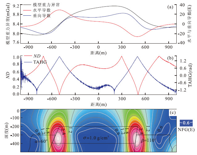
图 1 剖面模型试验示意与边界识别结果
a.模型重力异常与各方向导数;b.TAHG与ND方法结果;c.NFG方法结果与模型示意,黑色线框为模型示意
Fig. 1. The model diagram and results of edge detecting of the profile fault model

图 2 模型空间示意与边界识别结果
红色框线为模型平面投影位置,黑色、橙色及蓝色实线代表延拓0 m、50 m与100 m后的识别结果.a.模型空间分布示意;b.模型正演重力异常(含1.5%高斯噪声);c.TAHG(blakely算法(Blakely and Simpson, 1986)提取极大值);d.小波模极大值;e.ND(blakely算法提取极小值)
Fig. 2. The space distribution diagram and results of edge detection of the combined model
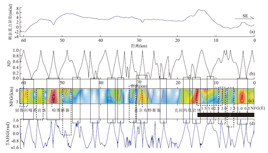
图 4 剖面布格重力异常及边界识别方法结果
黑色实线框表示3种方法均显示为边界的位置;黑色虚线框为2种方法显示为边界的位置;红色实曲线为地面调查中已发现断裂或岩体边界.a.局部重力异常;b.ND;c.NFG;d.TAHG
Fig. 4. The residual gravity anomaly and edge detection results of the profile data
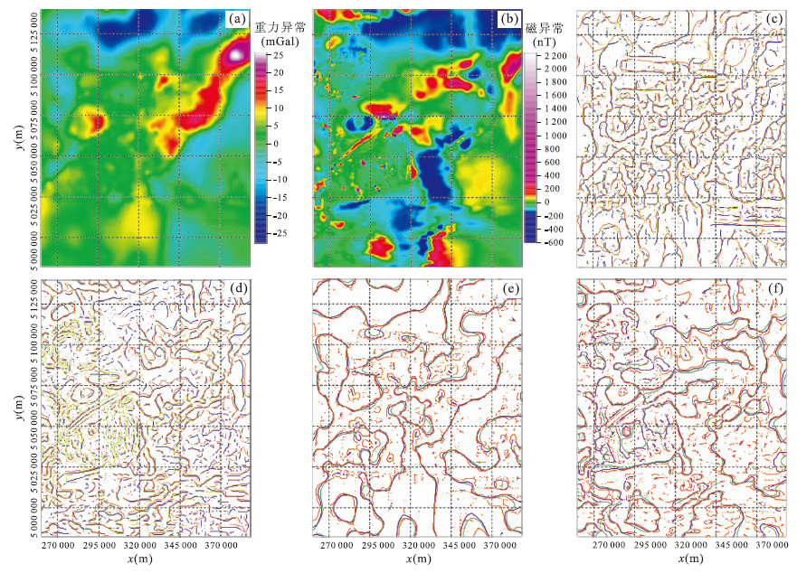
图 5 研究区平面数据及其边界识别结果
a.研究区局部重力异常;b.研究区航磁化极后异常;c.局部重力异常边界识别结果;d.航磁化极异常边界识别结果;e.局部重力异常多尺度ND方法边界识别结果;f.航磁化极异常多尺度ND方法边界识别结果.图c、d中蓝色为TAHG结果,橘色为ND结果,绿色为小波模极大值结果;图e、f中橘色为地面识别结果,紫色为延拓1 000 m后识别结果,绿色为延拓2 000 m后识别结果
Fig. 5. Gravity and magnetic data of the study area and their edge-detection results
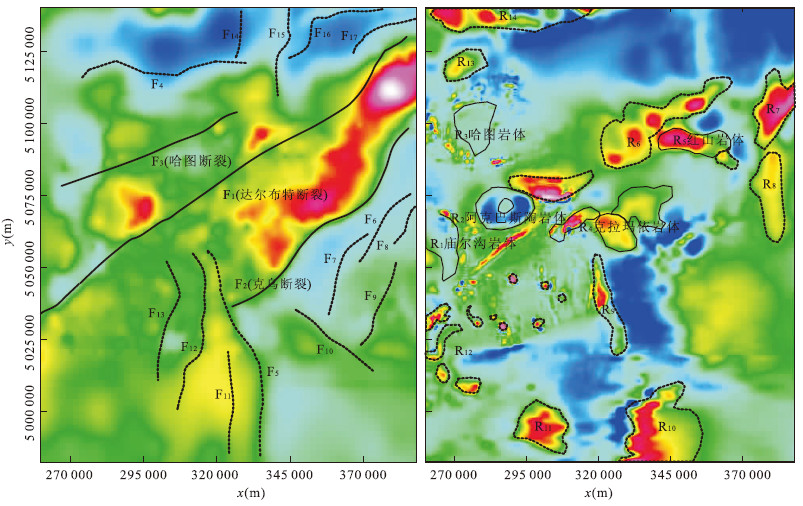
图 6 推测解释的断裂构造分布于主要岩体边界
a.推断断裂构造分布;b.推断解释的主要岩体边界.图中实线为证实存在的断裂与岩体;虚线为推断断裂与岩体
Fig. 6. The fault and rock masses distribution in the study area
表 1 组合模型参数
Table 1. Parameters of the combined model
模型编号 长度(m) 宽度(m) 厚度(m) 顶面埋深(m) 剩余密度(g/cm3) 模型1 500 500 300 80 0.8 模型2 1 400 500 320 60 1.0 模型3 1 000 600 280 100 1.2  下载: 导出CSV
-
Blakely, R.J., Simpson, R.W., 1986. Approximating Edges of Bodies from Magnetic or Gravity Anomalies. Geophysics, 51: 1494-1498. doi: 10.1190/1.1442197 Berezkin, V.M., 1994. Geophysical Prospecting Data of Total Gradient Interpretation Method. Translated by Lu, K., Liu, W.J., Jiao, E.F. . Geological Publishing House, Beijing, 31-57 (in Chinese). Cheng, Z.X., 1998. The Wavelet Analysis Algorithm and Application. Xi'an Jiaotong University Press, Xi'an (in Chinese). Cooper, G.R.J., Cowan, D.R., 2008. Edge Enhancement of Potential-Field Data Using Normalized Statistics. Geophysics, 73(3): 1-4. doi: 10.1190/1.2837309 Cordell, L., 1979. Gravimetric Expression of Graben Faulting in Santa Fe County and the Espanola Basin, New Mexic. New Mexico Geol. Soc. Guidebook, 30th Field Conf., New Mexico, 59-64. Francisco, J.F.F., Jeferson, D.S., Alessandra, D.B., 2013. Enhancement of the Total Horizontal Gradient of Magnetic Anomalies Using the Tilt Angle. Geophysics, 78(3): 34-41. doi: 10.1190/GEO2011-0441.1 Hood, P., McClure, D.J., 1965. Gradient Measurements in Ground Magnetic Prospecting. Geophysics, 30(3): 403-410. doi: 10.1190/1.1439592 Lü, P., Zhang, W., Liu, G., et al., 2013. Advances in 3-D Geological Mapping Taking by abroad Important Geological Surveys. Land and Resources Information, (3): 13-18 (in Chinese). Mallat, S., Zhong, S.F., 1992. Characterization of Signals from Multi-Scale Edges. IEEE Transactions on Pattern Analysis and Machine Intelligence, 14(7): 710-732. doi: ieeecomputersociety.org/10.1109/34.142909 Miller, H.G., Singh, V., 1994. Potential Field Tilt—A New Concept for Location of Potential Field Sources. Journal of Applied Geophysics, 32(2-3): 213-217. doi: 10.1016/0926-9851(94)90022-1 Nabighian, M.N., 1972. The Analytic Signal of Two-Dimensional Magnetic Bodies with Polygonal Cross-Section in Properties and Use for Automated Interpretation. Geophysics, 37(3): 507-517. doi: 10.1190/1.1440276 Nabighian, M.N., 1984. Toward a Three Dimensional Automatic Interpretation of Potential Field Data via Generalized Hilbert Transforms: Fundamental Relations. Geophysics, 49(6): 780-786. doi: 10.1190/1.1441706 Ping, S., Xiao, W., Ping, H.D., et al., 2013. Petrogenesis and Tectonic Settings of the Late Carboniferous Jiamantieliek and Baogutu Ore-Bearing Porphyry Intrusions in the Shouthern West Juggar, NW China. Journal of Asian Earth Sciences, 75: 158-173. doi: 10.1016/j.jseaes.2013.07.024 Strang, G., Nguyen, T., 1996. Wavelets and Filter Banks. 2ed Edition. Wellesley Press, Cambridge. Verduzco, B., Fairhead, J.D., Green, C.M., et al., 2004. New Insights into Magnetic Derivatives for Structural Mapping. The Leading Edge, 23: 116-119. doi: 10.1190/1.1651454 Wang, Y.G., 2010. Study and Application of High Precision Normalized Full Gradient of Gravity Anomaly Method (Dissertation). Jilin University, Changchun (in Chinese). Wang, Y.G., Zhang, F.X., Wang, Z.W., et al., 2013. Edge Detection of Potential Field Using Normalized Differential. Journal of Jilin University (Earth Science Edition), 43(2): 592-602 (in Chinese with English abstract). http://www.researchgate.net/publication/287164457_Edge_detection_of_potential_field_using_normalized_differential Wijns, C., Perez, C., Kowalczyk, P., 2005. Theta Map: Edge Detection in Magnetic Data. Geophysics, 70(4): 39-43. doi: 10.1190/1.1988184 Zhang, F.Q., Zhu, H.Y. Zhang, F.X., et al., 2008. Study and Application of Normalized Full Gradient of Gravity Anomalies and Phase Based on DCT in Identifying Fracture. Global Geology, 27(1): 83-88 (in Chinese with English abstract). Zhang, F.X., Meng, L.S., Zhang, F.Q., et al., 2005. Calculating Normalized Full Gradient of Gravity Anomaly Using Hilbert Transform. Chinese J. Geophys., 48(3): 704-709 (in Chinese with English abstract). doi: 10.1002/cjg2.712/full Zhang, H.L., Liu, T.Y., Yang, Y.S., 2011. Calculation of Gravity and Magnetic Source Boundary Based on Anisotropy Normalized Variance. Chinese J. Geophys, 54(7): 1921-1927 (in Chinese with English abstract). doi: 10.3969/j.issn.0001-5733.2011.07.026 Zheng, X., Wu, Z.C., Zhang Y.Y., et al., 2013. The New Progress of Overseas 3D-Geological Mapping. Journal of East China Institute of Technology (Social Science), 32(3): 397-402 (in Chinese with English abstract). http://en.cnki.com.cn/Article_en/CJFDTOTAL-FZSZ201303039.htm Zhu, B.J., 2013. The Study on the Application of Multi-Scale Wavelet Transforms Modulus Maxima in Boundary Detection of Potential Fields (Dissertation). Jilin University, Changchun (in Chinese with English abstract). 别列兹金, V.M., 1994. 物探数据的总梯度解释法. 陆克, 刘文锦, 焦恩富译. 北京: 地质出版社, 31-57. 程正兴, 1998. 小波分析算法与应用. 西安: 西安交通大学出版社. 吕鹏, 张炜, 刘国, 等, 2013. 国外重要地质调查机构三维地质填图工作进展. 国土资源情报, (3): 13-18. doi: 10.3969/j.issn.1674-3709.2013.03.003 王万银, 邱之云, 杨永, 等, 2010. 位场边缘识别方法研究进展. 地球物理学进展, 25(1): 196-210. https://www.cnki.com.cn/Article/CJFDTOTAL-DQWJ201001029.htm 王彦国, 张凤旭, 王祝文, 等, 2013. 位场归一化差分法的边界检测技术. 吉林大学学报(地球科学版), 43(2): 592-602. https://www.cnki.com.cn/Article/CJFDTOTAL-CCDZ201302029.htm 张凤琴, 朱洪英, 张凤旭, 等, 2008. 基于DCT的重力归一化总梯度及相位在识别断裂构造中的研究与应用. 世界地质, 27(1): 83-88. doi: 10.3969/j.issn.1004-5589.2008.01.016 张凤旭, 孟令顺, 张凤琴, 等, 2005. 利用Hilbert变换计算重力归一化总梯度. 地球物理学报, 48(3): 704-709. doi: 10.3321/j.issn:0001-5733.2005.03.031 张恒磊, 刘天佑, 杨宇山, 2011. 各向异性标准方差计算重磁源边界. 地球物理学报, 54(7): 1921-1927. doi: 10.3969/j.issn.0001-5733.2011.07.026 郑翔, 吴志春, 张洋洋, 等, 2013. 国外三维地质填图的新进展. 华东理工大学学报(社会科学版), 32(3): 397-402. https://www.cnki.com.cn/Article/CJFDTOTAL-FZSZ201303039.htm 朱保健, 2013. 多尺度小波模极大值法在位场边界检测中的应用研究(硕士毕业论文). 长春: 吉林大学. -

 点击查看大图
计量
- 文章访问数: 4666
- HTML全文浏览量: 713
- PDF下载量: 491
- 被引次数: 0
