


Quantitative Estimation of Surface Denudation in Longmen Shan during Late Cenozoic
-
摘要: 龙门山是青藏高原周边山脉中地形梯度变化最大的山脉.利用数字高程模型(digital elevation models, DEM),采用三维残余面法恢复龙门山晚新生代古残余面DEM,并与现代地形面做差值运算,得到研究区域的剥蚀量地形,进而定量估算青衣江、岷江、沱江和涪江主要水系流域晚新生代的地表剥蚀量.结果表明:龙门山晚新生代地表剥蚀总量为80 500~92 800 km3;岷江流域对龙门山地区剥蚀量贡献率约33.9%~37.1%,其次为涪江(33.6%~38.4%)、青衣江(24.1%~31.9%),沱江流域贡献率为0.4%~0.6%;类似2008年“5·12”汶川地震的次生灾害引发的地表快速剥蚀,是青藏高原东缘龙门山造山带晚新生代地表剥蚀的主要原因.Abstract: Longmen Shan located at the eastern margin of Tibetan Plateau represents the steepest gradient of the Tibetan Plateau edges. To assess the large-scale denudation volume in Longmen Shan, Late Cenozoic, surface denudation is quantitatively calculated along several large drainage basins such as Qingyijiang, Minjiang, Tuojiang, and Fujiang rivers by using digital elevation models (DEM) data, and residual surface method with paleo-residual surface DEM minus modern surface topography in this study. It is found that the Late Cenozoic denudation volume of upper reaches in Longmen Shan drainage basin is between 80 500 and 92 800 km3. Minjiang River has the largest contribution ratio to denudation in Longmen Shan (33.9%-37.1%), followed by Fujiang (33.6%-38.4%) and Qingyijiang Rivers (24.1%-31.9%), and Tuojiang River has minimum contribution (0.4%-0.6%). A rapid erosional removal from the Longmen Shan by repeated great seismic events like the Wenchuan earthquake on May 12th, 2008, may be a main reason of the surface erosion in Late Cenozoic Longmen Shan along the eastern margin of Tibetan Plateau.
-
Key words:
- Longmen Shan /
- Late Cenozoic /
- denudation /
- quantitative analysis /
- residual surface /
- tectonics
-
青藏高原东缘龙门山造山带,处于松潘-甘孜造山带与华南地块的结合部位,是进行青藏高原隆升与变形过程研究的典型地区.区内构造发育,水系侵蚀作用强烈,且受多期构造作用的影响,地质构造景观极为复杂(许志琴等,2007),在不到40 km的范围内,地形特征表现为四川盆地由海拔500~600 m变化到龙门山海拔5 000 m左右,龙门山的地形陡度比青藏高原南缘喜马拉雅山脉的地形陡度变化还要大(Burchfiel et al., 1995).
2008年5月12日发生于龙门山断裂带的汶川Ms8.0级大地震,形成了毁灭性的破坏,巨大地震产生的泥石流、滑坡等次生灾害引发了地表快速剥蚀(Ouimet, 2010; Parker et al., 2011;赵国华等,2014).Fu et al.(2011)认为龙门山地震的次生灾害引发了地表快速侵蚀,且长期的地表侵蚀卸载作用导致了下地壳和上地幔边界均衡反弹.刘锋等(2013)推测龙门山地区地震及其他地表过程所产生的剥蚀物质通过河流快速卸载驱动了地壳均衡反弹和深部物质上涌,形成了青藏高原东缘的高陡地形梯度带.Liu-Zeng et al.(2011)利用河流输沙量数据映射龙门山的现代剥蚀模式,并利用与推移质及溶质负载相关的悬浮沉积计算流域平均剥蚀速率.李勇等(2006)根据输沙量计算了岷江上游流域的短周期剥蚀速率和剥蚀量;根据岷江下蚀速率计算岷江上游流域中周期剥蚀速率与剥蚀量;根据裂变径迹测定结果计算岷江上游流域长周期剥蚀速率与剥蚀量.此外,Burbank et al.(2003)、Lamb and Davis(2003)、Molnar(2003)、Reiners et al.(2003)通过测量年降水量、汇水量和输沙量的变化,精确定量地刻画剥蚀作用.刘树根等(2003)测定了龙门山的彭灌杂岩及宝兴杂岩地表样品的4个磷灰石裂变径迹年龄,表明中新世以来这两个岩体上部至少剥蚀了5~6 km的岩石,平均剥蚀速率约为0.5~0.6 mm/a.Granger et al.(1996)、李英奎等(2005)以裂变径迹、宇宙核素法等热年代学数据为主要手段,研究剥蚀速率和剥蚀量.王岩(2011)利用数字高程模型技术,采用定量构造地貌和地表过程分析的研究思路和方法,探讨龙门山晚新生代构造隆升的新动力学机制,并定量估算龙门山晚新生代地表剥蚀量.Densmore et al.(2005)、李勇等(2005b)利用剥蚀卸载模拟技术研究山脉的剥蚀作用.
本文将结合前期对龙门山造山带晚新生代均衡反弹隆升的定量研究(王岩和刘少峰,2013),重点对所提出大地震活动相关的大规模滑坡、泥石流等快速侵蚀和剥蚀作用产生的地表剥蚀量进行定量估算.
1. 区域地质
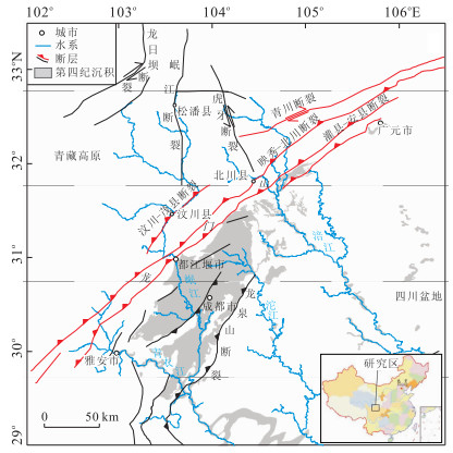
龙门山断裂带位于我国中部,沿四川盆地西缘呈北东-南西向延伸,具有地震活动性,是我国南北地震带的重要组成部分.主要发育3条大致平行的逆冲、逆冲兼走滑性质的断裂,即汶川-茂县断裂、映秀-北川断裂、灌县-安县断裂(图 1).汶川-茂县断裂又称龙门山后山断裂,是松潘-甘孜造山带内部的一条大型断裂带,印支期以来为挤压逆冲性质,“5·12”汶川地震时没有发生破裂,但泥石流、滑坡等地质灾害十分严重(许强和董秀军,2011;唐文清等,2012).映秀-北川断裂是龙门山逆冲断裂带的中央断裂(李勇等,2005a),是“5·12”汶川地震的主体地表发震断裂,汶川地震同震破裂基本沿早期断裂发育但是又不完全重叠(王焕等,2013).灌县-安县断裂又称龙门山前山断裂,沿龙门山与成都平原交界处分布,“5·12”汶川地震使灌县-安县断裂活动,并在其中段产生约80 km的同震地表破裂带(付碧宏等,2008;李海兵等,2008;徐锡伟等,2008; Liu-Zeng et al., 2009).
位于青藏高原东缘的龙门山与四川盆地是青藏高原周边最陡的地形梯度带,受高山冰雪融水和大气降水的共同补给,水系较为发育,从西南到东北依次发育青衣江、岷江、沱江和涪江等一系列斜交于龙门山断裂带的水系(贾营营等,2010).这些水系在龙门山断裂带内表现为基岩型河道和深切河谷,下切侵蚀作用强烈,进入山前四川盆地以后,水系呈扇状散开的特点,最后从四川盆地南部汇入长江(王岩和刘少峰,2013).地震诱发的泥石流、滑坡等次生灾害,具有沿地震断裂带及河谷两岸分布的空间特征,图 2为2010年11月进行龙门山野外地质调查时的照片.对于发育于大型山脉或高原水系的剥蚀量研究是解决山脉或高原隆升、环境变迁等问题的最佳途径(Dadson et al., 2003),同时对于区域剥蚀以及后期响应的均衡调整所引起的地壳表面隆升和高程变化的相关研究尤其重要(Raymo and Ruddiman, 1992; Small and Anderson, 1998).
 图 2 汶川大地震形成的龙门山地表剥蚀特征a.北川县附近山体出现大规模的滑坡;b.江油市永胜镇附近的山体崩塌;c.彭州市白鹿镇附近湔江;d.江油市南坝镇附近涪江;e.鸡冠山附近文锦江;f.九龙沟附近文锦江Fig. 2. Characteristics of the Longmen Shan surface erosion generated in the Wenchuan earthquake
2. 龙门山晚新生代地表剥蚀量的定量模拟
2.1 原理
依据龙门山地形起伏特征,以龙门山-四川盆地间起伏度变化最大的地区为界限,将青衣江、岷江、沱江及涪江上游水系流域范围作为龙门山研究区域,利用数字高程模型数据,恢复龙门山晚新生代古残余面数字高程模型(digital elevation models, DEM),并与现代地形面做差值运算,得到研究区域的剥蚀量地形,进而统计龙门山主要水系流域晚新生代地表剥蚀量.
基于数字高程模型数据,利用ArcGIS软件提取龙门山山系的平均坡度图,通过设定平均坡度阈值提取龙门山低起伏面.区域低起伏侵蚀面主要是指现今残存的低起伏面状地貌,包括山顶面、主夷平面及河流阶地,它们是在地壳处于长期相对稳定和气候比较湿润条件下,流水侵蚀和风化剥蚀作用的结果:若在内营力作用下地壳再次抬升,则可形成永久的地形标志.通过山脊包络线法去除山顶面以及地层识别法去除河流阶地面(王岩,2011)(即将第四纪地层及研究区低起伏地形覆盖于地形图之上),将海拔分布5 000~6 000 m的山脊包络线且分布于研究区低起伏范围内的区域作为山顶面(张世民等,2010),将第四纪地层中分布于研究区低起伏范围内且海拔较周边低的区域作为河流阶地.笔者将去除山顶面及河流阶地的低起伏分布区域与第四纪地层相叠加的区域的残余面分布区作为研究区.将残余面中的每一个栅格对应的矢量点作为残余面古地貌面恢复的基本样点,利用ArcGIS软件提供的插值算法,进行残余面古地貌面恢复.这里通过插值误差统计选择最优插值算法(王岩,2011),对恢复的残余面古地貌面与现代地形面进行差值运算,得到龙门山晚新生代以来的剥蚀量地形,从而进行剥蚀量统计分析,其具体流程图见图 3.
 图 3 残余面法估算龙门山山系剥蚀量流程Fig. 3. Flow chart of estimating denudation by residual surface method in Longmen Shan
将恢复的古残余面DEM减去现代高程DEM,正值代表岩石已被剥蚀,零值表示无剥蚀,负值表示现代地形高于恢复的古残余面地貌面(张会平,2006).计算后的数据表示剥蚀的最小值,因为很多地区最年轻的和最高的古盆地充填已被剥蚀,而留下的是老的、低处沉积,前期沉积充填面可能更高,剥蚀量可能更大.剥蚀量分析示意图见图 4.
2.2 分析
2.2.1 平均坡度
坡度是地表单元陡缓的程度,一般指坡面的铅直高度与水平宽度的比,表示高度变化的最大值比率,是地表面在该点的倾斜程度,也是最重要的地形因子之一.地表坡度记为S或tanβ.假如某个点的平面坐标为(i, j),那么其相邻的8个点中任何一个点的平面坐标可以表示为(i+m, j+n),其中m=-1, 0, 1,n=-1, 0, 1,m和n不能同时取零值.因此,从点(i, j)到其周围任一相邻点的地表坡度为:
S(i,j)→(i+m,j+n)=tanβ(i,j)→(i+m,j+n)=Z(i,j)−Z(i+m,j+n)√m2+n2×100%,i,j,m,n∈Z. (1) 假设重力是坡面流最主要的驱动力,那么当公式(1)计算得的S值大于0时,坡面流将从点(i, j)流向点(i+m, j+n);如果S值小于0时,坡面流将从点(i+m, j+n)流向点(i, j);如果S值等于0,那么在点(i, j)和点(i+m, j+n)之间将会没有任何水量交换.
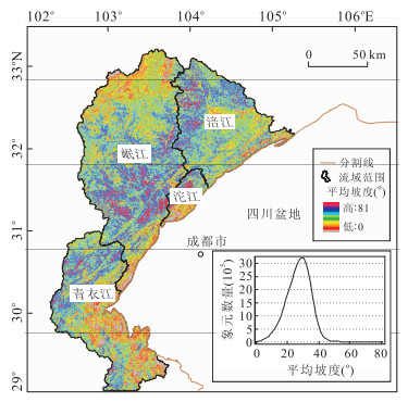
在一个特定区域内地面坡度的平均值,即地表的平均坡度,在宏观区域内可以反映地面的起伏程度.将原始DEM数据的坐标系统由地理坐标系统转化为投影坐标系统,运用ArcGIS 9.2的3D分析模块中的表面分析生成研究区坡度图.利用600 m×600 m的最佳统计窗口(王岩,2011)对龙门山地区坡度图进行平滑,得到平均坡度分布(图 5).龙门山平均坡度直方图呈正态分布,坡度范围为0°~81°,坡度众数值为29°.
2.2.2 龙门山残余面分布
究竟地表坡度值为多大时,才能称之为“残余面”呢?Twidale(1968)认为山麓面的坡度变化在1°~7°;Small(1978)和Goudie(2003)指出山麓面的坡度变化在0.15°~7°;而Goudie(1985)认为山麓面的坡度通常 < 10°;崔之久等(1996)强调高差可以有1 000 m,但坡降只有1‰,即1 000 km升高约1 000 m;崔之久等(1998)定义整个地面坡度不大于2‰或0.6°,汇水的浅槽谷平均值为10‰,最大为20‰~30‰(1.2°~1.7°),仅在平原上部边缘地区或远离河谷的岛山顶部坡度可达3.5°~4°;潘保田等(2004)认为准平原地面坡度应在1‰以下.冯金良等(2005)基于作者和前人研究结果,视坡降(坡度)≤7°、连续、大区域分布的平缓侵蚀面为残余面.可见,残余面的坡度并没有严格的划分界限.
经统计分析,龙门山山系平均坡度≤5°的区域面积占总面积的0.61%,平均坡度≤6°的区域面积占总面积的0.87%,平均坡度≤7°的区域面积占总面积的1.17%,平均坡度≤8°的区域面积占总面积的1.53%,平均坡度≤9°的区域面积占总面积的2.00%,平均坡度≤16°的区域面积占总面积的9.45%,平均坡度≤20°的区域面积占总面积的19.33%.本研究将区域面积1%的比例视为低起伏区域,取平均坡度≤7°、连续、大区域分布的平缓地区为低起伏面,利用分辨率为1 km的GTOPO30 DEM数据生成地形线,进一步去除山顶面及河流阶地后,与第四纪地层相叠加的区域作为残余面(图 6a).将残余面中的每一个栅格对应的矢量点作为残余面古地貌面恢复的基本样点(图 6b).
 图 6 龙门山残余面分布(a)和残余面古地貌面恢复样本点分布(b)Fig. 6. Residual surface map of Longmen Shan (a) and sample points distribution of residual surface recovery palaeo-geomorphology (b)
2.2.3 龙门山残余面古地貌面恢复
利用ArcGIS软件里的地统计分析模块,将残余面古地貌面恢复的基本样点经插值运算,可得到龙门山残余面古地貌恢复面.插值算法的选择直接影响数值预测的准确性,ArcGIS软件下提供了几种常用的插值方法:反距离权插值(IDW)、全局多项式插值(GPI)、局部多项式插值(LPI)、径向基函数插值(RBF),以及地统计插值协同克里格插值(Kriging),其他插值自然邻点法(NNI).通过对各种方法对比研究,最终确定最佳的插值算法.
将各种插值方法预测图误差综合对比(表 1).参考ArcGIS软件精度评价Prediction Errors中的几个指标(汤安国和杨昕,2000),符合以下标准的模型是最优的:平均误差(Mean)最接近于0,均方根预测误差(Root-Mean-Square)最小,其他误差还有平均标准误差(Average Stndard Error)最接近于均方根预测误差(Root-Mean-Square),标准均方根预测误差(Root-Mean-Square Stndardized)最接近于1.这里反距离权插值法平均误差(-0.000 4)最接近于0,协同克里格插值法的均方根预测误差最小为9.924,而自然邻点法是最新近的插值方法,ArcGIS软件没有给出该插值的误差估计.因此选择反距离权插值法、协同克里格插值法和自然邻点法插值得到的预测面为基础,进一步进行古剥蚀量计算(表 1).
表 1 各种插值方法预测图误差对比Table Supplementary Table Errors comparison by various interpolation methods prediction figure编号 插值方法 平均误差 均方根预测误差 1 反距离权插值法(IDW) -0.000 4 13.69 2 全局多项式插值(GPI) -0.001 6 238.90 3 局部多项式插值(LPI) 0.128 4 21.61 4 径向基函数插值法(RBF) -0.146 4 11.81 5 协同克里格插值(CoKring) -0.100 8 9.92 6 自然邻点法(NNI) 无预测值 无预测值 2.3 结果
以反距离权插值法、协同克里格插值法及自然邻点插值法插值得到的预测面为基础,分别取龙门山4条流域范围内各自残余面古地貌恢复面的峰值与现代地形DEM做差值运算,得到各流域范围内的剥蚀量地形(图 7),进行剥蚀量的统计运算(表 2)(Mcmillan, 2003).
 图 7 古残余面插值预测(a, c, e)和古残余面剥蚀量分布(b, d, f)a~b.反距离权插值法;c~d.协同克里格插值法;e~f.自然邻点法插值Fig. 7. Palaeo-residual surface interpolation prediction (a, c, e) and palaeo-residual surface denudation distribution (b, d, f)表 2 残余面法估算研究区剥蚀量Table Supplementary Table Denudation estimated by residual surface method
研究区 反距离权插值法 协同克里格插值法 自然邻点插值法 剥蚀量(km3) 比例(%) 剥蚀量(km3) 比例(%) 剥蚀量(km3) 比例(%) 青衣江 29 595.43 0.319 19 925.21 0.246 19 402.11 0.241 岷江 31 502.84 0.339 29 595.43 0.366 29 876.11 0.371 沱江 525.75 0.006 301.60 0.004 293.41 0.004 涪江 31 186.54 0.336 31 118.74 0.384 30 933.09 0.384 总量 92 810.56 80 940.99 80 504.72 利用反距离权插值法、协同克里格插值法及自然邻点插值法插值得到的剥蚀量分布地形,形态相似,最大剥蚀厚度均沿龙门山断裂带发育,最大可以达4 000 m以上.其中剥蚀厚度3 000 m及以上的地区主要集中在涪江及岷江下游,沿龙门山高山地貌区分布;在青衣江流域及岷江上游沿河谷两侧区域的剥蚀量达2 000 m左右;向高原内部延伸的区域及山前冲积平原区延伸方向(涪江流域),表面剥蚀厚度为1 000 m以下,部分地区抬升量大于剥蚀量,因此古剥蚀量恢复图中无法显示最终剥蚀量大小.
利用残余面分析法计算龙门山地区剥蚀量,由表 2可知,龙门山地区剥蚀总量为80 500~92 800 km3.岷江流域剥蚀量为29 600~31 500 km3,贡献率为33.9%~37.1%;涪江流域剥蚀量为31 000~31 200 km3,贡献率为33.6%~38.4%;青衣江流域剥蚀量为19 400~29 600 km3,贡献率为24.1%~31.9%;沱江流域剥蚀量为290~530 km3,贡献率为0.4%~0.5%.
3. 讨论
3.1 青衣江与岷江剥蚀量比较
为了进一步对比青衣江与岷江流域的剥蚀量贡献率,本文统计了龙门山前冲积平原内的第四纪沉积物分布情况(图 8,表 3).
 图 8 龙门山水系流域及第四纪沉积物空间分布F1.汶川-茂县断裂;F2.映秀-北川断裂;F3.灌县-安县断裂;F4.青川断裂;F5.虎牙断裂;F6.岷江断裂;F7.龙日坝断裂;F8.龙泉山断裂Fig. 8. Spatial distribution of river basin and quaternary sediments in Longmen Shan表 3 四川盆地第四纪沉积物分布面积统计Table Supplementary Table Distribution area statistics of Quaternary sediments in Sichuan basin
雅安砾岩 丹思砾岩 名邛砾岩 大邑砾岩 分布面积(km2) 2 881.85 870.48 942.48 153.36 总面积(km2) 2 881.85 1 812.96 153.36 来源 岷江 青衣江 青衣江和岷江 晚新生代以来,龙门山前冲积平原(成都盆地)自下而上依次充填了大邑砾岩、名邛砾石层、丹思砾石层、雅安砾石层及全新世以来松散的河流相冲积物(贾营营等, 2010).大邑砾岩为上新世晚至早更新世沉积,出露面积较小,且主要分布于龙门山山前的都江堰、大邑、邛崃等地区,发生了明显的构造变形.钱洪和唐荣昌(1997)及李勇等(2006)研究认为该套砾岩为古岷江和古青衣江出山后迅速卸载的冲洪积物.名邛砾石层形成于早更新世晚期至中更新世(崔志强等, 2009),位于熊坡背斜的西麓,南西起始于草坝乡青衣江畔,北东延伸至邛崃县,自南西向北东呈长扇状分布.丹思砾石层位于熊坡背斜的东南麓,形成于中更新世晚期-晚更新世早期(崔志强等, 2009),自西向东呈扇状分布,名邛砾石层与丹思砾石层二者空间上的展布方向均明显不同于现代岷江河道.地貌学证据及前人对该砾石层砾石长轴方向统计、物源分析及青衣江河流阶地研究(袁俊杰和陶晓风, 2008; 崔志强等, 2009; 唐熊和陶晓风, 2009; Wang et al., 2010),表明它们极有可能是古青衣江的冲洪积物.随着熊坡背斜及三苏场背斜向北东方向不断扩展,青衣江古河道北迁,水动力减弱并逐渐废弃,其残存断头河被袭夺并逐步演化成为现代岷江的支流,从此青衣江改道东南,而名邛砾石层和丹思砾石层沉积结束.古岷江受龙泉山及其西侧褶皱隆升作用的影响,主河道向西发生了迁移(贾营营等, 2010),沉积物在龙泉山一带迅速卸载,雅安砾石层开始沉积.
通过四川盆地第四纪沉积物分布面积分析(表 3),岷江流域第四纪沉积物分布面积较青衣江流域大1 070 km2,从某种意义上讲岷江流域对龙门山地区剥蚀量贡献率更大一些.综上所述,青藏高原东缘龙门山主要水系流域剥蚀总量为80 500~92 800 km3,其中岷江流域对龙门山地区剥蚀量贡献率为33.9%~37.1%.
3.2 “5·12”汶川地震对龙门山晚新生代剥蚀量的影响
以残余面法中自然邻点插值法定量估算青藏高原东缘龙门山地区的剥蚀量结果为依据,统计2008年“5·12”汶川地震灾区烈度8度及以上地区(付碧宏等, 2009; Wei et al., 2010)在研究区分布情况(图 9a),并统计汶川地震地质灾害点的分布情况(图 9b).汶川地震所影响范围大、地震烈度高,高烈度区域(9~11度)主要沿地震断裂带分布,地震诱发的滑坡、泥石流等次生灾害具有沿地震断裂带和河谷两岸分布的空间特征(Tang et al., 2010).汶川地震在近13 000 km2范围内触发了>56 000处滑坡,面积约750 km2(Dai et al., 2011).经统计,地震灾区地震烈度8度以上的面积达40 000 km2,地质灾害约2 870点,与研究区重叠部分面积约23 000 km2,在研究区范围内地震烈度8度及以上地区总剥蚀量为42 400 km3,占研究区剥蚀总量的46%~53%.其中岷江流域范围内地震烈度8度及以上地区剥蚀量为15 200 km3,地质灾害约1 240点,对研究区范围地震贡献率为35.81%.而前文利用残余面法定量估算岷江流域对龙门山剥蚀贡献率为33.9%~37.1%,两者结果十分相近,进一步表明类似汶川地震的巨大地震产生的滑坡、泥石流等次生灾害引发的地表快速剥蚀,是青藏高原东缘龙门山造山带晚新生代地表剥蚀的重要原因.
 图 9 “5·12”汶川地震烈度分布与剥蚀量叠加(a)及其诱发的地质灾害点的空间分布(b)Fig. 9. Overlay map of intensity and denudation in May 12th Wenchuan earthquake (a) and spatial distribution map of geological disaster points caused by the Wenchuan earthquake (b)
4. 结论
龙门山位于青藏高原东缘与四川盆地的交接部位,是青藏高原边缘山脉中陡度变化最大的山脉.本文以数字高程模型数据为基础,进行龙门山地区青衣江、岷江、沱江和涪江主要水系流域的晚新生代剥蚀量的定量估算.
(1) 龙门山晚新生代以来龙门山山系的剥蚀总量为80 500~92 800 km3.
(2) 岷江流域剥蚀量为29 600~31 500 km3,贡献率为33.9%~37.1%;涪江流域剥蚀量为31 000~31 200 km3,贡献率为33.6%~38.4%;青衣江流域剥蚀量为19 400~29 600 km3,贡献率为24.1%~31.9%;沱江流域剥蚀量为290~530 km3,贡献率为0.4%~0.5%.
(3) 2008年“5·12”汶川地震灾区烈度8度及以上地区,在研究区范围内总剥蚀量约42 400 km3,其中岷江流域范围内地震烈度8度及以上地区剥蚀量为15 200 km3,对研究区范围地震贡献率为35.81%.表明类似2008年汶川地震的巨大地震次生灾害引发的地表快速剥蚀,是青藏高原东缘龙门山造山带晚新生代地表剥蚀的主要原因.
-
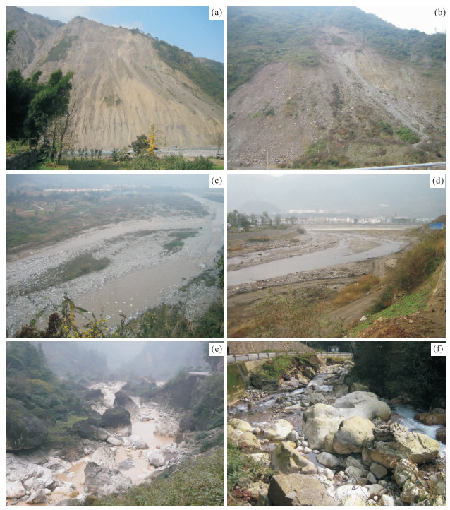
图 2 汶川大地震形成的龙门山地表剥蚀特征
a.北川县附近山体出现大规模的滑坡;b.江油市永胜镇附近的山体崩塌;c.彭州市白鹿镇附近湔江;d.江油市南坝镇附近涪江;e.鸡冠山附近文锦江;f.九龙沟附近文锦江
Fig. 2. Characteristics of the Longmen Shan surface erosion generated in the Wenchuan earthquake

图 3 残余面法估算龙门山山系剥蚀量流程
Fig. 3. Flow chart of estimating denudation by residual surface method in Longmen Shan
图 6 龙门山残余面分布(a)和残余面古地貌面恢复样本点分布(b)
Fig. 6. Residual surface map of Longmen Shan (a) and sample points distribution of residual surface recovery palaeo-geomorphology (b)

图 7 古残余面插值预测(a, c, e)和古残余面剥蚀量分布(b, d, f)
a~b.反距离权插值法;c~d.协同克里格插值法;e~f.自然邻点法插值
Fig. 7. Palaeo-residual surface interpolation prediction (a, c, e) and palaeo-residual surface denudation distribution (b, d, f)

图 8 龙门山水系流域及第四纪沉积物空间分布
F1.汶川-茂县断裂;F2.映秀-北川断裂;F3.灌县-安县断裂;F4.青川断裂;F5.虎牙断裂;F6.岷江断裂;F7.龙日坝断裂;F8.龙泉山断裂
Fig. 8. Spatial distribution of river basin and quaternary sediments in Longmen Shan
图 9 “5·12”汶川地震烈度分布与剥蚀量叠加(a)及其诱发的地质灾害点的空间分布(b)
Fig. 9. Overlay map of intensity and denudation in May 12th Wenchuan earthquake (a) and spatial distribution map of geological disaster points caused by the Wenchuan earthquake (b)
表 1 各种插值方法预测图误差对比
Table 1. Errors comparison by various interpolation methods prediction figure
编号 插值方法 平均误差 均方根预测误差 1 反距离权插值法(IDW) -0.000 4 13.69 2 全局多项式插值(GPI) -0.001 6 238.90 3 局部多项式插值(LPI) 0.128 4 21.61 4 径向基函数插值法(RBF) -0.146 4 11.81 5 协同克里格插值(CoKring) -0.100 8 9.92 6 自然邻点法(NNI) 无预测值 无预测值  下载: 导出CSV
表 2 残余面法估算研究区剥蚀量
Table 2. Denudation estimated by residual surface method
研究区 反距离权插值法 协同克里格插值法 自然邻点插值法 剥蚀量(km3) 比例(%) 剥蚀量(km3) 比例(%) 剥蚀量(km3) 比例(%) 青衣江 29 595.43 0.319 19 925.21 0.246 19 402.11 0.241 岷江 31 502.84 0.339 29 595.43 0.366 29 876.11 0.371 沱江 525.75 0.006 301.60 0.004 293.41 0.004 涪江 31 186.54 0.336 31 118.74 0.384 30 933.09 0.384 总量 92 810.56 80 940.99 80 504.72
下载: 导出CSV
表 3 四川盆地第四纪沉积物分布面积统计
Table 3. Distribution area statistics of Quaternary sediments in Sichuan basin
雅安砾岩 丹思砾岩 名邛砾岩 大邑砾岩 分布面积(km2) 2 881.85 870.48 942.48 153.36 总面积(km2) 2 881.85 1 812.96 153.36 来源 岷江 青衣江 青衣江和岷江
下载: 导出CSV
-
Burbank, D.W., Blythe, A.E., Putkonen, J., et al., 2003. Decoupling of Erosion and Precipitation in the Himalayas. Nature, 426(6967): 652-655. doi: 10.1038/nature02187 Burchfiel, B.C., Chen, Z.L., Liu, Y.P., 1995. Tectonics of the Longmen Shan and Adjacent Regions, Central China. International Geology Review, 37(8): 661-735. doi: 10.1080/00206819509465424 Cui, Z.J., Gao, Q.Z., Liu, G.N., et al., 1996. The Inital Elevation of Palaeokarst and Planation Surfaces on Tibet Plateau. Science in China (Series D), 26(4): 378-386 (in Chinese). Cui, Z.J., Li, D.W., Wu, Y.Q., et al., 1998. Comment on the Planation Surface. Chinese Science Bulletin, 43(17): 1794-1804 (in Chinese). doi: 10.1360/csb1998-43-17-1794 Cui, Z.Q., Liu, D.Z., Meng, Q.M., 2009. The Origin of the Pleistocene Gravel in Western Sichuan Depression. Geology in China, 36(5): 1065-1078 (in Chinese with English abstract). http://en.cnki.com.cn/Article_en/CJFDTOTAL-DIZI200905013.htm Dadson, S.J., Hovius, N., Chen, H., et al., 2003. Links between Erosion, Runoff Variability and Seismicity in the Taiwan Orogen. Nature, 426(6967): 648-651. doi: 10.1038/nature02150 Dai, F.C., Xu, C., Yao, X., et al., 2011. Spatial Distribution of Landslides Triggered by the 2008 Ms8.0 Wenchuan Earthquake, China. Journal of Asian Earth Sciences, 40(4): 883-895. doi: 10.1016/j.jseaes.2010.04.010 Densmore, A.L., Li, Y., Ellis, M.A., et al., 2005. Active Tectonics and Erosional Unloading at the Eastern Margin of the Tibetan Plateau. Journal of Mountain Science, 2(2): 146-154. doi: 10.1007/BF02918330 Feng, J.L., Cui, Z.J., Zhu, L.P., 2005. Review on the Planation Surface. Journal of Mountain Science, 23(1): 1-13 (in Chinese with English abstract). http://en.cnki.com.cn/Article_en/CJFDTOTAL-SDYA200501001.htm Fu, B.H., Shi, P.L., Guo, H.D., et al., 2011. Surface Deformation Related to the 2008 Wenchuan Earthquake, and Mountain Building of the Longmen Shan, Eastern Tibetan Plateau. Journal of Asian Earth Sciences, 40: 805-824. doi: 10.1016/j.jseaes.2010.11.011 Fu, B.H., Shi, P.L., Zhang, Z.W., 2008. Spatial Characteristics of the Surface Rupture Produced by the Ms8.0 Wenchuan Earthquake Using High-Resolution Remote Sensing Imagery. Acta Geologica Sinica, 82(12): 1679-1687 (in Chinese with English abstract). http://www.cqvip.com/Main/Detail.aspx?id=28269426 Fu, B.H., Wang, P., Kong, P., et al., 2009. Ms8.0 Wenchuan Earthquake of May 12th 2008—Earthquake Geological Disasters Atlas. Seismological Press, Beijing (in Chinese). Goudie, A., 1985. The Encyclopedia Dictionary of Physical Geography (Blackwell Reference). Blackwell Reference, London, 528. Goudie, A., 2003. The Encyclopedia of Geomorphology. Routledge, London, 818-820. Granger, D.E., Kirchner, J.W., Finkel, R., 1996. Spatially Averaged Long-Term Erosion Rates Measured from In Situ-Produced Cosmogenic Nuclides in Alluvial Sediments. The Journal of Geology, 104: 249-257. doi: 10.1002/esp.1493 Jia, Y.Y., Fu, B.H., Wang, Y., et al., 2010. Late Cenozoic Tectonic-Geomorphic Growth and Drainage Response in the Longmen Shan Fault Zone, East Margin of Tibet. Quaternary Sciences, 30(4): 825-836 (in Chinese with English abstract). http://www.researchgate.net/publication/285099537_Late_Cenozoic_tectono-geomorphic_growth_and_drainage_response_in_the_Longmen_Shan_fault_zone_east_margin_of_Tibet Lamb, S., Davis, D., 2003. Cenozoic Climate Change as a Possible Cause for the Rise of the Andes. Nature, 425(6960): 792-797. doi: 10.1038/nature02049 Li, H.B., Wang, Z.X., Fu, X.F., et al., 2008. The Surface Rupture Zone Distribution of the Wenchuan Earthquake (Ms8.0) Happened on May 12th, 2008. Geology in China, 35(5): 803-813 (in Chinese with English abstract). http://www.cqvip.com/Main/Detail.aspx?id=28269426 Li, Y.K., Harbor, J., Liu, G.N., 2005. Applications and Limitations of In-Situ Cosmogenic Nuclides in Earth Sciences. Research of Soil and Water Conservation, 12(4): 146-152 (in Chinese with English abstract). http://en.cnki.com.cn/Article_en/CJFDTOTAL-STBY200504042.htm Li, Y., Cao, S.Y., Zhou, R.J., et al., 2005a. Late Cenozoic Minjiang Incision Rate and Its Constraint on the Uplift of the Eastern Margin of the Tibetan Plateau. Acta Geologica Sinica, 79(1): 28-37 (in Chinese with English abstract). http://www.researchgate.net/publication/285785020_Late_Cenozoic_Minjiang_incision_rate_and_its_constraint_on_the_uplift_of_the_eastern_margin_of_the_Tibetan_Plateau Li, Y., Densmore, A.L., Zhou, R.J., et al., 2005b. Late Cenozoic Erosional Thickness and Flexural Deflection along the Eastern Margin of Tibetan Plateau. Acta Geologica Sinica, 79(5): 608-615 (in Chinese with English abstract). http://en.cnki.com.cn/Article_en/CJFDTOTAL-DZXE200505005.htm Li, Y., Zhou, R.J., Densmore, A.L., et al., 2006. Continental Dynamics and Geological Responses of the Eastern Margin of Qinghai-Tibet Plateau. Geological Publishing House, Beijing, 152 (in Chinese). Liu, F., Fu, B.H., Yang, S.H., 2013. Quantitative Estimation of the Evacuation Time of Landslide Mass and Sediment Induced by the Great Events Like 2008 Wenchuan Earthquake along the Minjiang River, Longmen Shan Orogenic Belt. Chinese Journal of Geophysics, 56(5): 1517-1525 (in Chinese with English abstract). http://en.cnki.com.cn/Article_en/CJFDTOTAL-DQWX201305011.htm Liu, S.G., Luo, Z.L., Zhao, X.K., et al., 2003. Coupling Relationships of Sedimentary Basin-Orogenic Belt Systems and Their Dynamic Models in West China—A Case Study of the Longmenshan Orogenic Belt-West Sichuan Foreland Basin System. Acta Geologica Sinica, 77(2): 177-186 (in Chinese with English abstract). http://www.cnki.com.cn/Article/CJFDTotal-DZXE200302007.htm Liu-Zeng, J., Wen, L., Oskin, M., et al., 2011. Focused Modern Denudation of the Longmen Shan Margin, Eastern Tibetan Plateau. Geochemistry, Geophysics, Geosystems, 12(11): Q11007. doi: 10.1029/2011GC003652 Liu-Zeng, J., Zhang, Z., Wen, L., et al., 2009. Co-Seismic Ruptures of the May 12th 2008, Ms8.0 Wenchuan Earthquake, Sichuan: East-West Crustal Shortening on Oblique, Parallel Thrusts along the Eastern Edge of Tibet. Earth and Planetary Science Letters, 286(3-4): 355-370. doi: 10.1016/j.epsl.2009.07.017 McMillan, M.E., 2003. Basin Fill, Erosion Surface and Tilted Markers: Evidence of Late Cenozoic Tectonic Uplift of the Rocky Mountain Orogenic Plateau (Dissertation). Wyoming University, Wyoming, 118. Molnar, P., 2003. Geomorphology: Nature, Nurture and Landscape. Nature, 426: 612-614. doi: 10.1038/426612a Ouimet, W.B., 2010. Landslides Associated with the May 12, 2008 Wenchuan Earthquake: Implications for the Erosion and Tectonic Evolution of the Longmen Shan. Tectonophysics, 491: 244-252. doi: 10.1016/j.tecto.2009.09.012 Pan, B.T., Gao, H.S., Li, B.Y., et al., 2004. Step-Like Landforms and Uplift of the Qinghai-Xizang Plateau. Quaternary Sciences, 24(1): 50-57 (in Chinese with English abstract). http://en.cnki.com.cn/Article_en/CJFDTOTAL-DSJJ200401005.htm Parker, R.N., Densmore, A.L., Rosser, N.J., et al., 2011. Mass Wasting Triggered by 2008 Wenchuan Earthquake is Greater than Orogenic Growth. Nature Geoscience, 4(4): 449-452. doi: 10.1038/ngeo1154 Qian, H., Tang, R.C., 1997. On the Formation and Evolution of the Chengdu Plain. Sichuan Earthquake, 3: 1-7 (in Chinese with English abstract). http://en.cnki.com.cn/Article_en/CJFDTOTAL-SCHZ199703000.htm Raymo, M.E., Ruddiman, W.F., 1992. Tectonic Forcing of Late Cenozoic Climate. Nature, 359: 117-122. doi: 10.1038/359117a0 Reiners, P.W., Ehlers, T.A., Mitchell, S.G., et al., 2003. Coupled Spatial Variation in Precipitation and Long-Term Erosion Rate across the Washington Cascades. Nature, 426(6967): 645-647. doi: 10.1038/nature02111 Small, E., Anderson, R., 1998. Pleistocene Relief Production in Laramide Mountain Ranges, Western United States. Geology, 26(2): 123-126. doi: 10.1130/0091-7613 Small, R.J., 1978. The Study of Landforms. In: Soerianegara, I., Lemmens, R.H.M.J., eds., Plant Resources of South-East Asia No. 5(1). Timber Trees: Major Commercial Timbers. Bogor, Indonesia (2ed). Cambridge University Press, London. Tang, A.G., Yang, X., 2000. ArcGIS Spatial Analysis Experiments Tutorial. Science Press, Beijing, 480 (in Chinese). Tang, H.M., Jia, H.B., Hu, X.L., et al., 2010. Characteristics of Landslides Induced by the Great Wenchuan Earthquake. Journal of Earth Science, 21(1): 104-113. doi: 10.1007/s12583-010-0008-1 Tang, W.Q., Zhang, Q.Z., Liu, Y.P., et al., 2012. Active Faulting along the Longmenshan Fault Zone after the 8.0 Magnitude Wenchuan Earthquake in Sichuan. Sedimentary Geology and Tethyan Geology, 32(4): 106-110 (in Chinese with English abstract). http://en.cnki.com.cn/Article_en/CJFDTOTAL-TTSD201204016.htm Tang, X., Tao, X.F., 2009. Analysis on Characteristics of Qingyi River Quaternary Terrace in Ya'an Area. Acta Sedimentologica Sinica, 27(1): 137-141 (in Chinese with English abstract). http://en.cnki.com.cn/Article_en/CJFDTOTAL-CJXB200901019.htm Twidale, C.R., 1968. Inselberg, Pediment. In: Fairbridge, R.W., ed., The Encyclopedia of Geomorphology. Dowden, Hutchinson & Ross Inc., Pennsylvania, 556-559, 817-818. Wang, H., Li, H.B., Si, J.L., et al., 2013. The Relationship between the Internal Structure of the Wenchuan Earthquake Fault Zone and the Uplift of the Longmenshan. Acta Petrologica Sinica, 29(6): 2048-2060 (in Chinese with English abstract). http://en.cnki.com.cn/Article_en/CJFDTOTAL-YSXB201306015.htm Wang, Y., 2011. Late Cenozoic Surface Denudation and Isostatic Rebound in Longmen Shan, East Tibet (Dissertation). China University of Geosciences, Beijing (in Chinese with English abstract). Wang, Y., Liu, S.F., 2013. Quantitative Research on Longmen Shan Uplift Caused by Late Cenozoic Isostatic Rebound. Geoscience, 27(2): 239-247 (in Chinese with English abstract). http://en.cnki.com.cn/Article_en/CJFDTOTAL-XDDZ201302001.htm Wang, Y., Zhang, T., Liu, S.F., et al., 2010. A New Model for Optimizing Relief Window Size. IEEE ICCSM, 12: 208-212. http://proceedings.spiedigitallibrary.org/proceeding.aspx?articleid=1668463 Wei, F.Q., Chernomorets, S., Aristov, K., et al., 2010. A Seismically Triggered Landslide in the Niujuan Valley near the Epicenter of the 2008 Wenchuan Earthquake. Journal of Earth Science, 21(6): 901-909. doi: 10.1007/s12583-010-0143-8 Xu, Q., Dong, X.J., 2011. Genetic Types of Large-Scale Landslides Induced by Wenchuan Earthquake. Earth Science—Journal of China University of Geosciences, 36(6): 1134-1142 (in Chinese with English abstract). doi: 10.1007%2F978-3-642-32238-9_54 Xu, X.W., Wen, X.Z., Ye, J.Q., et al., 2008. The Ms8.0 Wenchuan Earthquake Surface Ruptures and Its Seismogenic Structure. Seismology and Geology, 30(3): 597-629 (in Chinese with English abstract). http://en.cnki.com.cn/Article_en/CJFDTOTAL-DZDZ200803003.htm Xu, Z.Q., Li, H.Q., Hou, L.W., et al., 2007. Uplift of the Longmen-Jinping Orogenic Belt along the Eastern Margin of the Qinghai-Tibet Plateau: Large-Scale Detachment Faulting and Extrusion Mechanism. Geological Bulletin of China, 26(10): 1262-1276 (in Chinese with English abstract). http://en.cnki.com.cn/Article_en/CJFDTOTAL-ZQYD200710007.htm Yuan, J.J., Tao, X.F., 2008. The Features of Gravel Bed and Drainage Evolution in the Qingyi River Valley in the Mingshan-Danling Region, Sichuan. Acta Geologica Sichuan, 28(1): 6-12 (in Chinese with English abstract). http://en.cnki.com.cn/Article_en/CJFDTOTAL-SCDB200801002.htm Zhang, H.P., 2006. Study on Late Cenozoic Geomorphic Processes of Typical Regions along the Eastern and Northeastern Tibetan Margins (Dissertation). China University of Geosciences, Beijing (in Chinese with English abstract). Zhang, S.M., Ding, R., Mao, C.W., et al., 2010. Morphological Appearance of the Longmenshan Tectonic Uplift on the Eastern Margin of Tibetan Plateau. Quaternary Sciences, 30(4): 791-802 (in Chinese with English abstract). http://en.cnki.com.cn/Article_en/CJFDTOTAL-DSJJ201004016.htm Zhao, G.H., Li, Y., Yan, L., et al., 2014. Tectonic Geomorphology and Surface Erosion Processes in the Longmenshan Area after the 2008 Wenchuan Ms8.0 Earthquake—Take Haizi River of Jiangjian for Example. Earthquake Research in Sichuan, (1): 15-23 (in Chinese with English abstract). http://en.cnki.com.cn/Article_en/CJFDTotal-SCHZ201401005.htm 崔之久, 高全洲, 刘耕年, 等, 1996. 夷平面、古岩溶与青藏高原隆起. 中国科学(D辑), 26(4): 378-386. 崔之久, 李德文, 伍永秋, 等, 1998. 关于夷平面. 科学通报, 43(17): 1794-1804. doi: 10.3321/j.issn:0023-074X.1998.17.002 崔志强, 刘登忠, 孟庆敏, 2009. 川西凹陷地区更新统砾石层沉积成因探讨. 中国地质, 36(5): 1065-1078. doi: 10.3969/j.issn.1000-3657.2009.05.011 冯金良, 崔之久, 朱立平, 2005. 夷平面研究评述. 山地学报, 23(1): 1-13. doi: 10.3969/j.issn.1008-2786.2005.01.001 付碧宏, 时丕龙, 张之武, 2008. 四川汶川Ms8.0大地震地表破裂带的遥感影像解析. 地质学报, 82(12): 1679-1687. doi: 10.3321/j.issn:0001-5717.2008.12.005 付碧宏, 王萍, 孔屏, 等, 2009. 中国汶川"5·12" 8.0级大地震-地震地质灾害图集. 北京: 地震出版社. 贾营营, 付碧宏, 王岩, 等, 2010. 青藏高原东缘龙门山断裂带晚新生代构造地貌生长及水系响应. 第四纪研究, 30(4): 825-836. doi: 10.3969/j.issn.1001-7410.2010.04.17 李海兵, 王宗秀, 付小方, 等, 2008.2008年5月12日汶川地震(Ms8.0)地表破裂带的分布特征. 中国地质, 35(5): 803-813. doi: 10.3969/j.issn.1000-3657.2008.05.002 李英奎, Harbor, J., 刘耕年, 2005. 宇宙核素地学研究的应用现状与存在的问题. 水土保持研究, 12(4): 146-152. doi: 10.3969/j.issn.1005-3409.2005.04.042 李勇, 曹叔尤, 周荣军, 等, 2005a. 晚新生代岷江下蚀速率及其对青藏高原东缘山脉隆升机制和形成时限的定量约束. 地质学报, 79(1): 28-37. https://www.cnki.com.cn/Article/CJFDTOTAL-DZXE200501003.htm 李勇, Densmore, A.L., 周荣军, 等, 2005b. 青藏高原东缘龙门山晚新生代剥蚀厚度与弹性挠曲模拟. 地质学报, 79(5): 608-615. https://www.cnki.com.cn/Article/CJFDTOTAL-DZXE200505005.htm 李勇, 周荣军, Densmore, A.L., 等, 2006. 青藏高原东缘大陆动力学过程与地质响应. 北京: 地质出版社, 152. 刘锋, 付碧宏, 杨顺虎, 2013. 龙门山地区类似2008年汶川大地震滑坡物质河流卸载时间的定量估算. 地球物理学报, 56(5): 1517-1525. https://www.cnki.com.cn/Article/CJFDTOTAL-DQWX201305011.htm 刘树根, 罗志立, 赵锡奎, 等, 2003. 中国西部盆山系统的耦合关系及其动力学模式——以龙门山造山带-川西前陆盆地系统为例. 地质学报, 77(2): 791-802. https://www.cnki.com.cn/Article/CJFDTOTAL-DZXE200302007.htm 潘保田, 高红山, 李炳元, 等, 2004. 青藏高原层状地貌与高原隆升. 第四纪研究, 24(1): 50-57. doi: 10.3321/j.issn:1001-7410.2004.01.006 钱洪, 唐荣昌, 1997. 成都平原的形成与演化. 四川地震, (3): 1-7. https://www.cnki.com.cn/Article/CJFDTOTAL-SCHZ199703000.htm 汤安国, 杨昕, 2000. ArcGIS地理信息系统空间分析实验教程. 北京: 科学出版社, 480. 唐文清, 张清志, 刘宇平, 等, 2012. 汶川地震后龙门山断裂带活动特征. 沉积与特提斯地质, 32(4): 106-110. doi: 10.3969/j.issn.1009-3850.2012.04.016 唐熊, 陶晓风, 2009. 雅安地区青衣江流域第四纪阶地特征分析. 沉积学报, 27(1): 137-141. https://www.cnki.com.cn/Article/CJFDTOTAL-CJXB200901019.htm 王焕, 李海兵, 司家亮, 等, 2013. 汶川地震断裂带结构特征与龙门山隆升的关系. 岩石学报, 29(6): 2048-2060. https://www.cnki.com.cn/Article/CJFDTOTAL-YSXB201306015.htm 王岩, 2011. 龙门山晚新生代地表剥蚀与均衡抬升(博士学位论文). 北京: 中国地质大学. 王岩, 刘少峰, 2013. 龙门山晚新生代均衡反弹隆升的定量研究. 现代地质, 27(2): 239-247. doi: 10.3969/j.issn.1000-8527.2013.02.001 许强, 董秀军, 2011. 汶川地震大型滑坡成因模式. 地球科学——中国地质大学学报, 36(6): 1134-1142. https://www.cnki.com.cn/Article/CJFDTOTAL-DQKX201106019.htm 徐锡伟, 闻学泽, 叶建青, 等, 2008. 汶川Ms8.0地震地表破裂带及其发震构造. 地震地质, 30(3): 597-629. doi: 10.3969/j.issn.0253-4967.2008.03.003 许志琴, 李化启, 侯立炜, 等, 2007. 青藏高原东缘龙门山锦屏山造山带的崛起——大型拆离断层和挤出机制. 地质通报, 26(10): 1262-1276. doi: 10.3969/j.issn.1671-2552.2007.10.005 袁俊杰, 陶晓风, 2008. 四川名山-丹棱地区青衣江流域的砾石层特征及水系演化. 四川地质学报, 28(1): 6-12. doi: 10.3969/j.issn.1006-0995.2008.01.002 张会平, 2006. 青藏高原东缘-东北缘典型地区晚新生代地貌过程研究(博士学位论文). 北京: 中国地质大学. 张世民, 丁锐, 毛昌伟, 等, 2010. 青藏高原东缘龙门山山系构造隆起的地貌表现. 第四纪研究, 30(4): 791-802. doi: 10.3969/j.issn.1001-7410.2010.04.14 赵国华, 李勇, 闫亮, 等, 2014. 汶川Ms8.0级地震后龙门山构造地貌及地表侵蚀过程研究——以湔江海子段河为例. 四川地震, (1): 15-23. https://www.cnki.com.cn/Article/CJFDTOTAL-SCHZ201401005.htm 期刊类型引用(4)
1. 闫亮,李勇,邓涛,颜照坤,云锟,邵崇建,董顺利. 龙门山构造带晚新生代剥蚀作用与均衡隆升的地表过程研究. 地球学报. 2019(01): 76-92 .  百度学术
百度学术2. 程光锁,于学峰,杨斌,胡戈,李兆营,周军,刘卫东,罗文强,马祥县. 利用水系沉积物高程定量恢复古地貌的技术方法——以鲁西白彦地区白彦砾岩为例. 山东国土资源. 2019(09): 61-73 . 百度学术3. 万永平,李海龙,李云,宋志杰,李园园,祁攀文. 鄂尔多斯盆地东部晚侏罗世-早白垩世应力场. 地球科学. 2017(04): 549-558 .  本站查看
本站查看4. 王伟锋,朱传华,张晓杰,卿艳彬,单新建. 龙门山断裂带横断层成因类型及地质意义. 地球科学. 2016(05): 729-741 . 本站查看其他类型引用(4)
-


 下载:
下载:


 百度学术
百度学术 点击查看大图
计量
- 文章访问数: 3446
- HTML全文浏览量: 507
- PDF下载量: 542
- 被引次数: 8
