


Mineral Alteration Information Extraction Based on SREM Fusion Data
-
-
关键词:
- 多光谱图像光谱分辨率增强方法融合数据 /
- 蚀变信息提取 /
- 斑岩铜矿 /
- 混合调制匹配滤波 /
- 遥感
-
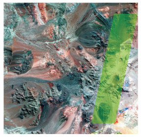
图 1 ASTER多光谱数据与Hyperion高光谱数据幅宽对比
Fig. 1. The different breadth of ASTER data and Hyperion data

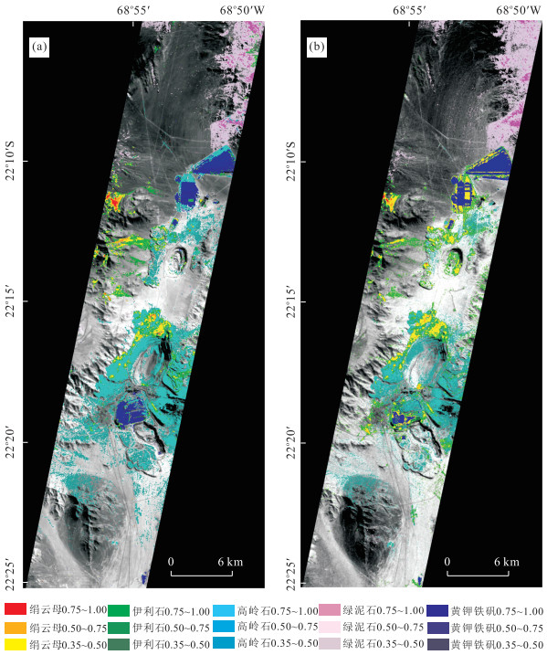
图 5 Hyperion(a)与SREM融合数据(b)矿物分布(重合区域)
Fig. 5. Alteration minerals distribution maps of Hyperion (a) and SREM fusion data (b)
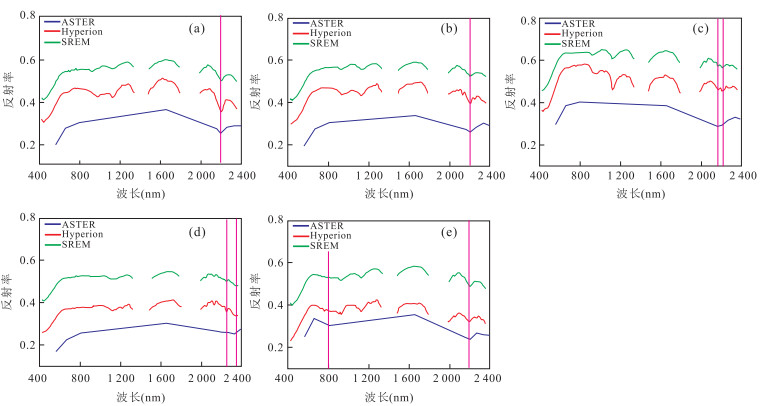
图 6 ASTER、Hyperion和SREM融合数据矿物光谱曲线对比
a.绢云母;b.伊利石;c.高岭石;d.绿泥石;e.黄钾铁矾
Fig. 6. The difference of minerals spectral curves between ASTER, Hyperion and SREM fusion data
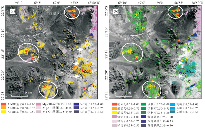
图 7 ASTER (a)与SREM融合数据蚀变矿物分布(b)
Fig. 7. Alteration minerals distribution of ASTER (a) and SREM fusion data (b)
表 1 SREM融合数据和Hyperion光谱相似性
Table 1. Spectral similarity between SREM fusion data and Hyperion
矿物类型 绢云母 伊利石 高岭石 绿泥石 黄钾铁矾 SAM(度) 3.332 9 2.615 5 2.356 5 2.968 3 4.590 5 UIQI 0.979 9 0.989 4 0.983 8 0.985 9 0.974 9  下载: 导出CSV
表 2 Hyperion与SREM融合数据矿物精度分析
Table 2. The accuracy of minerals between Hyperion data and SREM fusion data
矿物类型 制图精度(%) 用户精度(%) 伊利石 70.52 71.77 绢云母 68.97 64.45 高岭石 95.17 92.13 绿泥石 96.21 99.86 黄钾铁矾 92.18 89.74 总体精度(%) 92.85 Kappa系数0.897 3
下载: 导出CSV
表 3 ASTER与SREM融合数据矿物精度分析
Table 3. The accuracy of minerals between ASTER data and SREM fusion data
矿物类型 制图精度(%) 用户精度(%) Al-OH 95.10 90.08 Mg-OH 93.26 97.66 Fe3+ 85.11 60.08 总体精度(%) 90.561 7 Kappa系数0.811 6
下载: 导出CSV
-
Cudahy, T., Hewson, R., Huntington, J., et al., 2001. The Performance of the Satellite-Borne Hyperion Hyperspectral VNIR-SWIR Imaging System for Mineral Mapping at Mount Fitton, South Australia. Geoscience and Remote Sensing Symposium, IEEE 2001 International, 314-316. doi: doi:10.1109/IGARSS.2001.976142 DiPietro, R., Manolakis, D., Lockwood, R., et al., 2010. Performance Evaluation of Hyperspectral Detection Algorithms for Subpixel Objects. Proceeding of SPIE, (7695): 76951W. doi: 10.1117/12.850036 Eismann, M.T., Hardie, R.C., 2004. Application of the Stochastic Mixing Model to Hyperspectral Resolution Enhancement. Geoscience and Remote Sensing, IEEE Transactions on, 42(9): 1924-1933. doi: 10.1109/TGRS.2004.830644 Gan, F.P., Wang, R.S., Yang, S.M., 2002. Studying on the Alteration Minerals Identification Using Hyperion Data. Remote Sensing for Land & Resources, (4): 44-50(in Chinese with English abstract). Hosseinjani, Z.M., Tangestani, M.H., Roldan, F.V., et al., 2014. Sub-Pixel Mineral Mapping of a Porphyry Copper Belt Using EO-1 Hyperion Data. Advances in Space Research, 53(3): 440-451. doi: 10.1016/j.asr.2013.11.029 Iwasaki, A., Tonooka, H., 2005. Validation of a Crosstalk Correction Algorithm for ASTER/SWIR. Geoscience and Remote Sensing, IEEE Transactions on, 43(12): 2747-2751. doi: 10.1109/TGRS.2005.855066 Kruse, F.A., Boardman, J.W., Huntington, J.F., 1999. Fifteen Years of Hyperspectral Data: Northern Grapevine Mountains, Nevada. Proceedings of the 8th JPL Airborne Earth Science Workshop, (99-17): 247-258. Lin, N., Yang, W.N., Liu, H.H., 2011. Mineral Endmember Identification and Information Extraction Based on Hyperspectral Remote Sening. Remote Sensing Information, (5): 114-117 (in Chinese with English abstract). Liu, B., Zhang, L.F., Zhang, X., et al., 2009. Simulation of EO-1 Hyperion Data from ALI Multispectral Data Based on the Spectral Reconstruction Approach. Sensors, 9(4): 3090-3108. doi: 10.3390/s90403090 Lopez, V.M., 1939. The Primary Mineralization at Chuquicamata, Chile, S.A. . Economic Geology, 34(6): 674-711. doi: 10.2113/gsecongeo.34.6.674 Mayumi, N., Iwasaki, A., 2011. Image Sharpening Using Hyperspectral and Multispectral Data. Geoscience and Remote Sensing Symposium, IEEE International, 519-522. doi: 10.1109/IGARSS.2011.6049179 Ossandón, G., Gustafson, L.B., Lindsay, D.D., et al., 2001. Geology of the Chuquicamata Mine: A Progress Report. Economic Geology, 96(2): 249-270. doi: 10.2113/gsecongeo.96.2.249 Qian, Z.Q., Fang, Y.Y., Shi, J.L., 2014. Research Characteristics of Remote Sensing Technology in Overseas Mineral Exploration. Resource Development & Market, 30(7): 781-784 (in Chinese with English abstract). Sun, X.J., Zhang L.F., Yang, H., et al., 2014. Enhancement of Spectral Resolution for Remotely Sensed Multi-Spectral Image. IEEE Journal of Selected Topics in Applied Earth Observations and Remote Sensing, doi: 10.1109/JSTARS.2014.2356512 Tan, B.X., Li, Z.Y., Chen, E.X., et al., 2005. Preprocessing of EO-1 Hyperion Hyperspectral Data. Remote Sensing Information, (6): 36-41 (in Chinese with English abstract). Tian, F., Dong, L.N., Yang, S.M., et al., 2010. Application of Combined Spectra of Mixed Minerals to Mapping Altered Minerals: A Case Study in the Yunnan Region Based on Hyperion Data. Geology and Exploration, 46(2): 331-337(in Chinese with English abstract). Tong, Q.X., Zhang, B., Zhen, L.F., 2006. Hyperspectral Remote Sensing. Principle, Technology and Application. Higher Education Press, Beijing (in Chinese). Wang, Z., Bovik, A.C., 2002. A Universal Image Quality Index. Signal Processing Letters, IEEE, 9(3): 81-84. doi: 10.1109/97.995823 Winter, M.E., Winter, E.M., Beaven, S.G., et al., 2007. Hyperspectral Image Sharpening Using Multispectral Data. Aerospace Conference, IEEE, 1-9. doi: 10.1109/AERO.2007.353060 Yokoya, N., Yairi, T., Iwasaki, A., 2012. Coupled Nonnegative Matrix Factorization Unmixing for Hyperspectral and Multispectral Data Fusion. Geoscience and Remote Sensing, IEEE Transactions on, 50(2): 528-537. doi: 10.1109/TGRS.2011.2161320 Yuhas, R.H., Goetz, A.F., Boardman, J.W., 1992. Discrimination among Semi-Arid Landscape Endmembers Using the Spectral Angle Mapper (SAM) Algorithm. Summaries of 3rd Annual JPL Airborne Geoscience Workshop, Jet Porpulsion Laboratory. Zhang, J., Song, R., Yu, W.X., et al., 2005. Construction of Hierarchical Classifiers Based on the Confusion Matrix and Fisher's Principle. Journal of Software, 16(9): 1560-1567 (in Chinese with English abstract). doi: 10.1360/jos161560 Zhang, Y.F., de Backer, S., Scheunders, P., 2009. Noise-Resistant Wavelet—Based Bayesian Fusion of Multispectral and Hyperspectral Images. Geoscience and Remote Sensing, IEEE Transactions on, 47(11): 3834-3843. doi: 10.1109/TGRS.2009.2017737 Zhao, Y.S., 2003. Analysis Principle and Method of Remote Sensing Applications. Science Press, Beijing (in Chinese). 甘甫平, 王润生, 杨苏明, 2002. 西藏Hyperion数据蚀变矿物识别初步研究. 国土资源遥感, (4): 44-50. doi: 10.3969/j.issn.1001-070X.2002.04.010 林娜, 杨武年, 刘汉湖, 2011. 基于高光谱遥感的岩矿端元识别及信息提取研究. 遥感信息, (5): 114-117. 钱志奇, 房莹莹, 石剑龙, 2014. 遥感技术在境外矿产勘查中的特点研究. 资源开发与市场, 30(7): 781-784. doi: 10.3969/j.issn.1005-8141.2014.07.005 谭炳香, 李增元, 陈尔学, 等, 2005. EO-1 Hyperion高光谱数据的预处理. 遥感信息, (6): 36-41. doi: 10.3969/j.issn.1000-3177.2005.06.010 田丰, 董丽娜, 杨苏明, 等, 2010. 混合矿物组合光谱在蚀变矿物填图中的应用——以云南香格里拉地区Hyperion数据蚀变矿物填图为例. 地质与勘探, 46(2): 331-337. 童庆禧, 张兵, 郑兰芬, 2006. 高光谱遥感: 原理, 技术与应用. 北京: 高等教育出版社. 张静, 宋锐, 郁文贤, 等, 2005. 基于混淆矩阵和Fisher准则构造层次化分类器. 软件学报, 16(9): 1560-1567. 赵英时, 2003. 遥感应用分析原理与方法. 北京: 科学出版社, 202-208. -

 点击查看大图
计量
- 文章访问数: 3497
- HTML全文浏览量: 344
- PDF下载量: 302
- 被引次数: 0
