


Hyperspectral Mineral Mapping Method Based on Spectral Characteristic Parameter Combination
-
摘要: 受大气环境等因素的影响, 高光谱遥感矿物识别难以达到较高的精度.为解决该问题, 根据光谱吸收特征参数在大气变化中能保持相对稳定的特点, 提出一种基于光谱特征参数组合的高光谱矿物类型识别方法.文中计算了多种光谱特征参数, 通过最佳指数因子(optimum index factor, OIF)优选特征参数组合, 选定最佳特征参数组合, 利用模式识别方法实现矿物识别.利用机载可见/红外成像光谱仪(airborne visible infrared imaging spectrometer, AVIRIS)高光谱数据, 在美国内华达州Cuprite矿区进行了该方法的应用试验研究, 并与前人矿物填图结果做了对比.结果表明: 吸收波谷位置-吸收面积-吸收右肩位置(P-A-S2)光谱特征参数组合的矿物识别效果最优, 整体精度达到74.68%.Abstract: Influenced by the atmospheric environment and other factors, the mineral recognition with hyperspectral remote sensing is difficult to achieve a high accuracy. To improve the accuracy of the mineral identification with such technology, a hyperspectral mineral recognition method based on spectral characteristic parameter combination, which can maintain relatively stable characteristics with the atmospheric changes, is proposed in this paper. Various spectral characteristic parameters are calculated, and the optimal combination of the parameters is selected through the optimum index factor (OIF), based on which, mineral identification is realized with pattern recognition method. Based on the above method, mineral type identification test is carried out in Cuprite mine of Nevada, with airborne visible infrared imaging spectrometer (AVIRIS) hyperspectral data. The results are compared with the work of previous mineral mapping, it shows that the combination of the spectral characteristic parameters, P-A-S2 (P is absorption wave trough position, A is absorption area, S2 is absorption right shoulder position) can get the highest identification precision, the overall accuracy can reach 74.68%.
-
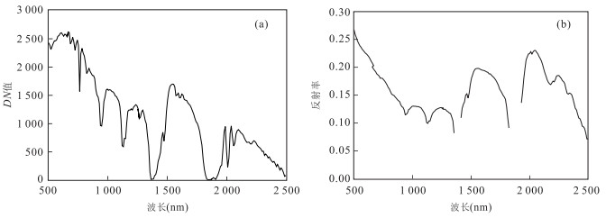
图 1 AVIRIS数据大气校正前后的光谱曲线
a为大气校正前;b为大气校正后
Fig. 1. Spectrum after atmospheric correction of AVIRIS data
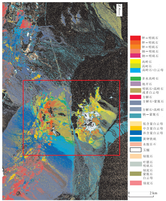
图 2 USGS在Cuprite矿区的矿物填图结果
Fig. 2. Mineral mapping result in the Cuprite mining area made by USGS
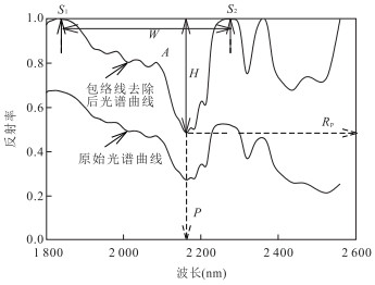
图 3 光谱吸收特征参数示意
Fig. 3. The schematic diagram of spectral absorption characteristic parameters

图 4 光谱特征参数影像假彩色合成影像
a为W-S-S2彩色合成影像;b为P-A-S2彩色合成影像
Fig. 4. False color composition image of characteristic parameters image
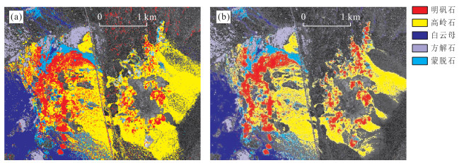
图 5 不同光谱特征参数组合的Cuprite矿区矿物填图结果
a为W-S-S2组合矿物填图结果;b为P-A-S2组合矿物填图结果
Fig. 5. Mineral mapping results under different spectral characteristic parameters combination in Cuprite
表 1 AVIRIS光谱特征参数影像OIF计算结果
Table 1. The OIF calculation result of AVIRIS spectral characteristic parameters
排名 特征参数1 特征参数2 特征参数3 OIF 1 W S S2 6 529.205 4 2 P A S2 3 166.070 6 3 P W S2 1 869.845 3 4 P K S2 1 658.919 5 5 W H S2 1 179.317 2 6 P R K 728.601 90 7 W A SAI 520.429 52 8 P K S1 321.255 93 9 K S1 S2 294.259 42 10 W H K 258.377 96  下载: 导出CSV
表 2 不同光谱特征参数组合的矿物填图精度对比分析
Table 2. Classification accuracies of mineral mapping for different spectral characteristic parameters combination
精度评价 W-S-S2组合 P-A-S2组合 生产者精度(%) 用户精度(%) 生产者精度(%) 用户精度(%) 明矾石 58.48 64.47 67.58 74.66 高岭石 74.84 66.06 71.49 71.17 白云母 88.73 97.57 90.23 93.55 蒙脱石 18.16 21.82 33.43 19.06 方解石 89.94 85.02 88.95 84.72 Kappa系数 0.580 5 0.651 9 整体精度(%) 70.07 74.68
下载: 导出CSV
-
Baugh, W.M., Kruse, F.A., Atkinson, W.W., 1998. Quantitative Geochemical Mapping of Ammonium Minerals in the Southern Cedar Mountains, Nevada, Using the Airborne Visible/Infrared Imaging Spectrometer (AVIRIS). Remote Sensing of Environment, 65(3): 292-308. doi: 10.1016/s0034-4257(98)00039-x Chavez, P.S., Berlin, G.L., Sowers, L.B., 1982. Statistical Method for Selecting Landsat MSS Ratios. Journal of Applied Photographic Engineering, 8(1): 23-30. http://ci.nii.ac.jp/naid/80001173869 Chen, X.F., Warner, T.A., Campagna, D.J., 2007. Integrating Visible, Near-Infrared and Short-Wave Infrared Hyperspectral and Multispectral Thermal Imagery for Geological Mapping at Cuprite, Nevada. Remote Sensing of Environment, 110(3): 344-356. doi: 10.1016/j.rse.2007.03.015 Clark, R.N., King, T.V.V., Klejwa, M., et al., 1990. High Spectral Resolution Reflectance Spectroscopy of Minerals. Journal of Geophysical Research, 95(B8): 12653-12680. doi: 10.1029/jb095ib08p12653 Clark, R.N., Swayze, G.A., 1995. Mapping Mineral, Amorphous Materials, Environmental Materials, Vegetation, Water, Ice and Snow, and Other Materials: The USGS Tricorder Algorithm. Summaries of the Fifth Annual JPL Airborne Earth Science Workshop, JPL Publication, 39-40. Clark, R.N., Swayze, G.A., 1996. Evolution in Imaging Spectroscopy Analysis and Sensor Signal-to-Noise: An examination of How Far We Have Come. Summaries of the 6th Annual JPL Airborne Geosciences Workshop, JPL Publication, 96(4): 49-53. http://speclab.cr.usgs.gov/PAPERS.imspec.evol/aviris.evolution.html Clark, R.N., Swayze, G.A., Livo, K.E., et al., 2003. Imaging Spectroscopy: Earth and Planetary Remote Sensing with the USGS Tetracorder and Expert Systems. Journal of Geophysical Research, 108(E12): 5131-5135. doi: 10.1029/2002je001847 Crowley, J.K., Brickey, D.W., Rowan, L.C., 1989. Airborne Imaging Spectrometer Data of the Ruby Mountains, Montana: Mineral Discrimination Using Relative Absorption Band-Depth Images. Remote Sensing of Environment, 29(2): 121-134. doi: 10.1016/0034-4257(89)90021-7 Friedl, M.A., McIver, D.K., Hodges, J.C.F., et al., 2002. Global Land Cover Mapping from MODIS: Algorithms and Early Results. Remote Sensing of Environment, 83(1-2): 287-302. doi: 10.1016/s0034-4257(02)00078-0 Felde, G.W., Anderson, G.P., Cooley, T.W., et al., 2003. Analysis of Hyperion Data with the FLAASH Atmospheric Correction Algorithm. IEEE International Geoscience and Remote Sensing Symposium (IGARSS), (1): 90-92. doi: 10.1109/IGARSS.2003.1293688 Gan, F.P., Liu, S.W., Zhou, Q., 2004. Identification of Mining Pollution Using Hyperion Data at Dexing Copper Mine in Jiangxi Province, China. Earth Science—Journal of China University of Geosciences, 29(1): 119-126 (in Chinese with English abstract). http://en.cnki.com.cn/Article_en/CJFDTOTAL-DQKX200401020.htm Gan, F.P., Wang, R.S., 2007. The Application of the Hyperspectral Imaging Technique to Geological Investigation. Remote Sensing for Land & Resources, 19(4): 57-60, 127-128 (in Chinese with English abstract). http://en.cnki.com.cn/Article_en/CJFDTOTAL-GTYG200704014.htm Gan, F.P., Wang, R.S., Ma, A.N., 2003. Spectral Identification Tree (SIT) for Mineral Extraction Based on Spectral Characteristics of Minerals. Earth Science Frontiers, 10(2): 445-454 (in Chinese with English abstract). He, Z.H., He, B.B., 2011. Weight Spectral Angle Mapper (WSAM) Method for Hyperspectral Mineral Mapping. Spectroscopy and Spectral Analysis, 31(8): 2200-2204 (in Chinese with English abstract). http://www.cqvip.com/QK/90993X/201108/38715065.html Hook, S.J., Gabell, A.R., Green, A.A., et al., 1992. A Comparison of Techniques for Extracting Emissivity Information from Thermal Infrared Data for Geologic Studies. Remote Sensing of Environment, 42(2): 123-135. doi: 10.1016/0034-4257(92)90096-3 Huang, X.M., Hsu, P.H., 2012. Comparisom of Wavelet-Based and HHT-Based Feature Extraction Methods for Hyperspectral Image Classification. ISPRS-International Archives of the Photogrammetry, Remote Sensing and Spatial Information Sciences, XXXIX-B7: 121-126. doi: 10.5194/isprsarchives-XXXIX-B7-121-2012 Huang, Z., Turner, B.J., Dury, S.J., et al., 2004. Estimating Foliage Nitrogen Concentration from HYMAP Data Using Continuum Removal Analysis. Remote Sensing of Environment, 93(1-2): 18-29. doi: 10.1016/j.rse.2004.06.008 Iordache, M.D., Bioucas-Dias, J.M., Plaza, A., 2014. Collaborative Sparse Regression for Hyperspectral Unmixing. IEEE Transactions on Geoscience and Remote Sensing, 52(1): 341-354. doi: 10.1109/TGRS.2013.2240001 Kruse, F.A., Raines, G.L., Watson, K., 1985. Analytical Techniques for Extracting Geologic Information from Multichannel Airborne Spectroradiometer Airborne Imaging Spectrometer Data. Proceedings, International Symposium on Remote Sensing of Environment, Thematic Conference on Remote Sensing for Exploration Geology, 4th, Environmental Research Institute of Michigan, Ann Arbor. Ma, N., Hu, Y.F., Zhuang, D.F., et al., 2010. Determination on the Optimum Band Combination of HJ-1A Hyperspectral Data in the Case Region of Dongguan Based on Optimum Index Factor and J-M Distance. Remote Sensing Technology and Application, 25(3): 358-365 (in Chinese with English abstract). http://www.oalib.com/paper/1468704 Robila, S.A., 2005. Using Spectral Distances for Speedup in Hyperspectral Image Processing. International Journal of Remote Sensing, 26(24): 5629-5650. doi: 10.1080/01431160500168728 Su, H.J., Du, P.J., 2006. Study on Feature Selection and Extraction of Hyperspectral Data. Remote Sensing Technology and Application, 21(4): 288-293 (in Chinese with English abstract). http://en.cnki.com.cn/Article_en/CJFDTOTAL-YGJS200604003.htm Swayze, G.A., 1997. The Hydrothermal and Structural History of the Cuprite Mining District, Southwestern Nevada: An Integrated Geological and Geophysical Approach(Dissertation). University of Colorado at Boulder, USA. van der Meer, F., Bakker, W., 1997. CCSM: Cross Correlogram Spectral Matching. International Journal of Remote Sensing, 18(5): 1197-1201. doi: 10.1080/014311697218674 van der Meer, F., 2000. Spectral Curve Shape Matching with a Continuum Removed CCSM Algorithm. International Journal of Remote Sensing, 21(16): 3179-3185. doi: 10.1080/01431160050145063 van der Meer, F., 2006. The Effectiveness of Spectral Similarity Measures for the Analysis of Hyperspectral Imagery. International Journal of Applied Earth Observation and Geoinformation, 8(1): 3-17. doi: 10.1016/j.jag.2005.06.001 Wang, R.S., Gan, F.P., Yan, B.K., et al., 2010. Hyperspectral Mineral Mapping and Its Application. Remote Sensing for Land & Resources, (1): 1-13 (in Chinese with English abstract). http://www.gtzyyg.com/CN/article/downloadArticleFile.do?attachType=PDF&id=434 Wang, R.S., Yang, S.M., Yan, B.K., 2007. A Review of Mineral Spectral Identification Methods and Models with Imaging Spectrometer. Remote Sensing for Land & Resources, (1): 1-9 (in Chinese with English abstract). http://en.cnki.com.cn/Article_en/CJFDTOTAL-GTYG200701000.htm Wu, C.S., Murray, A.T., 2003. Estimating Impervious Surface Distribution by Spectral Mixture Analysis. Remote Sensing of Environment, 84(4): 493-505. doi: 10.1016/s0034-4257(02)00136-0 Wu, W., Shao, G.F., 2002. Optimal Combinations of Data, Classifiers, and Sampling Methods for Accurate Characterizations of Deforestation. Canadian Journal of Remote Sensing, 28(4): 601-609. doi: 10.5589/m02-050 Xu, N., Hu, Y.X., Lei, B., et al., 2011. Mineral Information Extraction for Hyperspectral Image Based on Modified Spectral Feature Fitting Algorithm. Spectroscopy and Spectral Analysis, 31(6): 1639-1643 (in Chinese with English abstract). http://www.ncbi.nlm.nih.gov/pubmed/21847949 Yu, X.C., Xiong, L.P., Xu, J.D., et al., 2014. Mineral Mapping Based on Secondary Scattering Mixture Model. Remote Sensing for Land & Resources, 26(2): 60-68 (in Chinese with English abstract). http://en.cnki.com.cn/Article_en/CJFDTOTAL-GTYG201402011.htm Zhang, X.B., Yuan, Y., Jing, J.J., et al., 2011. Spectral Discrimination Method Information Divergence Combined with Gradient Angle. Spectroscopy and Spectral Analysis, 31(3): 853-857 (in Chinese with English abstract). http://europepmc.org/abstract/MED/21595255 甘甫平, 刘圣伟, 周强, 2004. 德兴铜矿矿山污染高光谱遥感直接识别研究. 地球科学——中国地质大学学报, 29(1): 119-126. https://www.cnki.com.cn/Article/CJFDTOTAL-DQKX200401020.htm 甘甫平, 王润生, 2007. 高光谱遥感技术在地质领域中的应用. 国土资源遥感, 19(4): 57-60, 127-128. doi: 10.3969/j.issn.1001-070X.2007.04.013 甘甫平, 王润生, 马蔼乃, 2003. 基于特征谱带的高光谱遥感矿物谱系识别. 地学前缘, 10(2): 445-454. doi: 10.3321/j.issn:1005-2321.2003.02.024 何中海, 何彬彬, 2011. 基于权重光谱角制图的高光谱矿物填图方法. 光谱学与光谱分析, 31(8): 2200-2204. doi: 10.3964/j.issn.1000-0593(2011)08-2200-05 马娜, 胡云峰, 庄大方, 等, 2010. 基于最佳波段指数和J-M距离可分性的高光谱数据最佳波段组合选取研究. 遥感技术与应用, 25(3): 358-365. https://www.cnki.com.cn/Article/CJFDTOTAL-YGJS201003010.htm 苏红军, 杜培军, 2006. 高光谱数据特征选择与特征提取研究. 遥感技术与应用, 21(4): 288-293. doi: 10.3969/j.issn.1004-0323.2006.04.004 王润生, 杨苏明, 阎柏琨, 2007. 成像光谱矿物识别方法与识别模型评述. 国土资源与遥感, (1): 1-9. https://www.cnki.com.cn/Article/CJFDTOTAL-GTYG200701000.htm 王润生, 甘甫平, 闫柏琨, 等, 2010. 高光谱矿物填图技术与应用研究. 国土资源遥感, (1): 1-13. https://www.cnki.com.cn/Article/CJFDTOTAL-GTYG201001002.htm 许宁, 胡玉新, 雷斌, 等, 2011. 基于改进光谱特征拟合算法的高光谱数据矿物信息提取. 光谱学与光谱分析, 31(6): 1639-1643. doi: 10.3964/j.issn.1000-0593(2011)06-1639-05 余先川, 熊利平, 徐金东, 等, 2014. 基于二次散射非线性混合模型的矿物填图方法. 国土资源遥感, 26(2): 60-68. https://www.cnki.com.cn/Article/CJFDTOTAL-GTYG201402011.htm 张修宝, 袁艳, 景娟娟, 等, 2011. 信息散度与梯度角正切相结合的光谱区分方法. 光谱学与光谱分析, 31(3): 853-857. doi: 10.3964/j.issn.1000-0593(2011)03-0853-05 -

 点击查看大图
计量
- 文章访问数: 3627
- HTML全文浏览量: 653
- PDF下载量: 299
- 被引次数: 0
