


A Comparative Study on Plum-Rain-Triggered Landslide Susceptibility Assessment Models in West Zhejiang Province
-
摘要: 我国目前滑坡易发性评价研究主要集中在西南地区,对东南部降雨引发特别是梅雨引发的滑坡研究较少.选取浙江省西北部梅雨控制区淳安县为研究区,通过遥感解译结合野外详细调查,共确定滑坡596处,并建立滑坡编录数据库.选取高程、坡向、坡度、曲率、工程岩组、断层、道路、建设用地、植被等9个滑坡影响因子,基于GIS栅格分析方法,采用人工神经网络(ANN)、logistic回归和信息量3种评价模型,分别对32种不同影响因子组合进行滑坡易发性对比评价,得到滑坡易发性指数图.应用评价曲线下面积AUC(area under curve)对评价结果进行检验,ANN、logistic回归和信息量3种模型的正确率分别是93.75%、89.76%和90.06%;采用淳安县2014年梅汛期发生的13处滑坡作为预测样本,3种模型预测率分别是94.75%、94.33%和77.21%.上述分析结果表明:ANN模型优于其他两者.以ANN模型评价结果指数图为基础进行易发性分区,采用滑坡强度指标进行分区结果检验,滑坡强度值由易发性低、较低、中和高依次递增,说明分区结果合理.研究成果可以为浙西降雨型滑坡特别是由梅雨引发滑坡的易发性评价提供参考.Abstract: A plenty of landslide susceptibility mapping studies in south west China have been reported in literatures. However, the assessment studies of rainfall-triggered landslides in south east China are still limited, particularly for those dominated by plum rains. Based on GIS and grid analysis, a study case in Cunan county is selected for demonstrating the comparison of applying three methods for landslide susceptibility assessment. They include artificial neural networks (ANN), logistic regression (LGR) and information model (IFM). The landslide inventory includes totally 596 landslides, which is established based on the results of remote sensing interpretation and detail survey. Totally 32 models are established by altering different combinations of controlling factors (CFs) out of totally 9 factors, including elevation, slope angle, slope aspect, slope curvature, lithology, distance from faults, distance from roads, distance from construction lands and vegetation. The indicator of Area Under Curve (AUC) is used for model evaluation. The ANN model could achieve the AUC of 93.75%, which outperforms LGR and IFM with the AUC of 89.76% and 90.06%, respectively. It also performs well in prediction to achieve the AUC of 94.75% compared to those (i.e. 94.33% and 77.21%) from LGR and IFM, where 13 landslides occurred in 2014 during plum-rain season are used for verification. The results of susceptibility zoning based on the derived susceptibility map using ANN also show reasonable, indicating the increases of landslide intensity with the increasing of susceptibility levels. Overall, this study demonstrates the best practices of applying different methods in rainfall-triggered landslide susceptibility assessment, which could be the reference for similar studies elsewhere in west Zhejiang province.
-
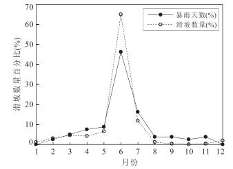
图 2 淳安县滑坡与暴雨事件时间分布
Fig. 2. The relationship between the landslides and storm events in Cunan county
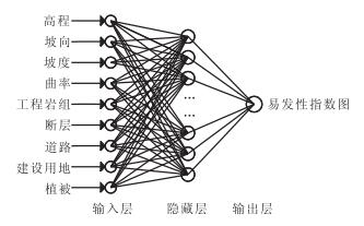
图 3 滑坡易发性评价前馈神经网络结构
Fig. 3. Architecture of back-propagation neural network for landslide susceptibility assessment
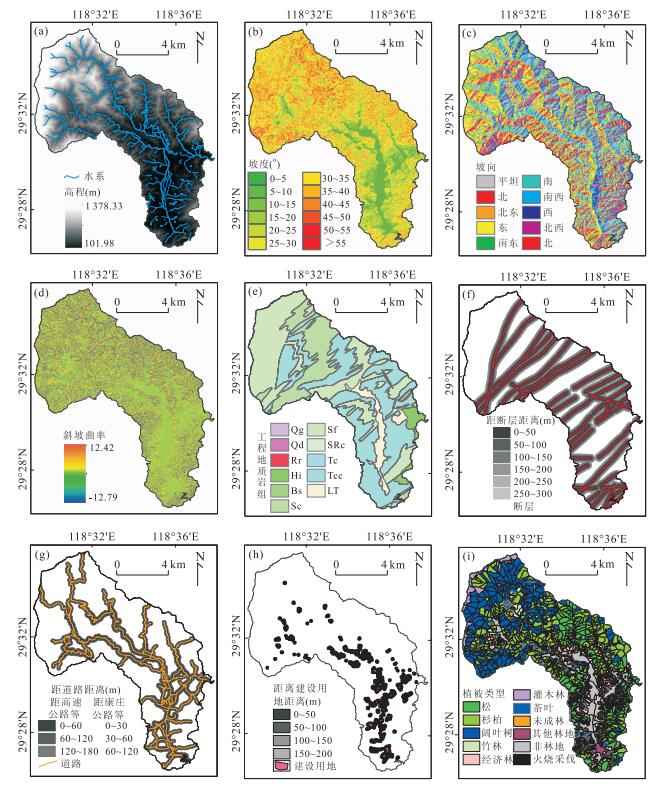
图 4 滑坡影响因子栅格图(局部,浪川乡)
a.高程;b.坡度;c.坡向;d.斜坡曲率;e.工程地质岩组;f.距断层距离;g.距道路距离;h.距建设用地距离;i.植被类型
Fig. 4. Raster maps of the landslide controlling factors
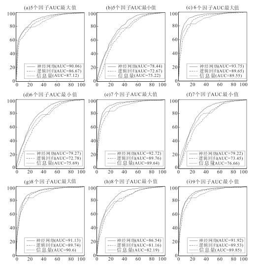
图 5 不同滑坡影响因子组合下3种评价模型易发性评价成功率检验曲线
横轴代表易发性面积百分比累加,纵轴代表实际滑坡数量百分比累加;a.5个因子AUC最大值-组合5;b.5个因子AUC最小值-信息量和神经网络组合4,logistic回归组合2;c.6个因子AUC最大值-组合16;d.6个因子AUC最小值-组合14;e.7个因子AUC最大值-信息量和神经网络组合25,logistic回归组合26;f.7个因子AUC最小值-组合17;g.8个因子AUC最大值-信息量和神经网络为组合29,logistic回归为组合31;h.8个因子AUC最小值-组合28;i.9个因子AUC-组合32
Fig. 5. Success rate curves of landslide susceptibility maps derived from three assessment models with different combinations of controlling factors
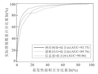
图 6 最大AUC值组合3种评价模型易发性评价成功率检验曲线
Fig. 6. Success rate curves of landslide susceptibility maps derived from three assessment models with the maximal AUC value combination of controlling factors
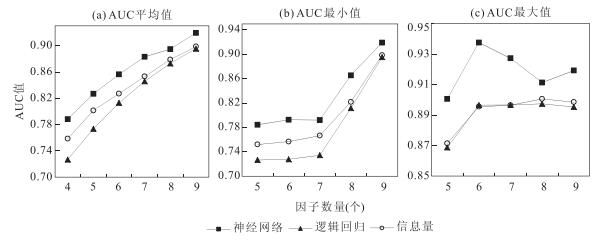
图 7 不同数量因子组合下3种模型AUC均值对比
横轴代表因子数量,纵轴代表AUC值
Fig. 7. Comparison of mean AUC using three assessment models with different controlling factors versus number of controlling factors
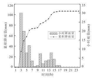
图 8 淳安千岛湖站2014年6月27日观测小时雨量
Fig. 8. Hourly rainfall observed at Qiandao Lake, Cunan on June 27th, 2014

图 9 3种评价模型易发性评价预测率检验曲线
检验样本:2014年梅汛期淳安新发生13处灾害点
Fig. 9. The prediction rate of the three models using area under curve (AUC)

图 10 各易发性等级面积和滑坡数量统计
Fig. 10. Statistics of various susceptibility levels with corresponding landslide occurrence percentage and intensity
表 1 滑坡影响因子及其分类标准
Table 1. Landslide controlling factors with their categories
类别 编号 影响因子 分级数量 分类标准 数据源 地形 A 高程(m) 9 1:<100;2:100~200;3:200~300;4:300~400;5:400~500;6:500~600;7:600~700;8:700~800;9:800~900;10:900~1 000;11:1 000~1 100;12:>1 100 ASTER GDEM B 坡度(°) 12 1:<5;2:5~10;3:10~15;4:15~20;5:20~25;6:25~30;7:30~35;8:35~40;9:40~45;10:45~50;11:50~55;12:>55 C 坡向 9 1:Flat;2:N;3:NE;4:E;5:SE;6:S;7:SW;8:W;9:NW 根据ASTER GDEM生成 D 斜坡曲率 12 1:<-10;2:-10~-8;3:-8~-6;4:-6~-4;5:-4~-2;6:-2~0;7:0~2;8:2~4;9:4~6;10:6~8;11:8~10;12:>10 地质 E 工程地质岩组 12 1:Qg;2:Qd;3:Rr;4:Hi;5:Bs;6:Sc;7:Sf;8:SRc;9:Tc;10:Tcc;11:LT;12:NT 1:5万或1:20万区域地质图 F 距断层距离(m) 7 1:0~50;2:50~100;3:100~150;4:150~200;5:200~250;6:250~300;7:>300 人类活动 G 距道路距离(m) 4 1:高速公路、国道、省道和县道(0~60 m),康庄公路、乡村道路(0~30 m);2:高速公路、国道、省道和县道(60~120 m),康庄公路、乡村道路(30~60 m);3:高速公路、国道、省道和县道(120~180 m),康庄公路、乡村道路(60~90 m);4:其他区域 1:5万地形图 H 距建设用地距离(m) 5 1:0~50;2:50~100;3:100~150;4:150~200;5:>200 第2次土地调查数据 其他 I 植被类型 11 1:杉柏;2:松;3:阔叶树;4:经济林;5:茶叶;6:竹林;7:灌木林;8:其他林地;9:未成林;10:火烧采伐;11:非林地 森林资源调查数据  下载: 导出CSV
表 2 不同影响因子组合下3种滑坡易发性评价模型的AUC检验结果
Table 2. AUC of landslide susceptibility assessment using three models with different combinations of controlling factors
因子数 组合编号 因子列表 AUC值(%) 信息量 ANN logistic回归 4个 组合1 坡度、岩组、道路、高程 75.84 78.82 72.67 5个 组合2 坡度、岩组、道路、高程、坡向 76.37 78.51 72.67 组合3 坡度、岩组、道路、高程、曲率 77.06 80.77 73.31 组合4 坡度、岩组、道路、高程、断层 75.22 78.44 72.83 组合5 坡度、岩组、道路、高程、建设 87.12 90.06 86.87 组合6 坡度、岩组、道路、高程、植被 81.84 85.49 81.11 6个 组合7 坡度、岩组、道路、高程、坡向、曲率 77.58 79.88 73.32 组合8 坡度、岩组、道路、高程、坡向、断层 75.69 79.27 72.78 组合9 坡度、岩组、道路、高程、坡向、建设 87.55 87.58 86.37 组合10 坡度、岩组、道路、高程、坡向、植被 82.24 85.06 80.99 组合11 坡度、岩组、道路、高程、曲率、断层 76.24 80.04 73.48 组合12 坡度、岩组、道路、高程、曲率、建设 87.44 89.15 87.01 组合13 坡度、岩组、道路、高程、曲率、植被 81.76 85.83 81.19 组合14 坡度、岩组、道路、高程、断层、建设 87.06 89.85 86.93 组合15 坡度、岩组、道路、高程、断层、植被 81.60 85.91 81.16 组合16 坡度、岩组、道路、高程、建设、植被 89.55 93.75 89.65 7个 组合17 坡度、岩组、道路、高程、坡向、曲率、断层 76.66 79.22 73.45 组合18 坡度、岩组、道路、高程、坡向、曲率、建设 88.08 89.54 86.59 组合19 坡度、岩组、道路、高程、坡向、曲率、植被 82.74 87.21 81.09 组合20 坡度、岩组、道路、高程、坡向、断层、建设 87.41 89.2 86.44 组合21 坡度、岩组、道路、高程、坡向、断层、植被 81.89 85.99 81.04 组合22 坡度、岩组、道路、高程、坡向、建设、植被 89.64 92.16 89.39 组合23 坡度、岩组、道路、高程、曲率、断层、建设 87.50 89.10 87.04 组合24 坡度、岩组、道路、高程、曲率、断层、植被 79.96 85.81 81.26 组合25 坡度、岩组、道路、高程、曲率、建设、植被 89.64 92.72 89.66 组合26 坡度、岩组、道路、高程、断层、建设、植被 89.58 91.99 89.76 8个 组合27 坡度、岩组、道路、高程、坡向、曲率、断层、建设 87.67 88.48 86.65 组合28 坡度、岩组、道路、高程、坡向、曲率、断层、植被 82.19 86.54 81.16 组合29 坡度、岩组、道路、高程、坡向、曲率、建设、植被 90.06 91.13 89.41 组合30 坡度、岩组、道路、高程、坡向、断层、建设、植被 89.79 90.10 89.49 组合31 坡度、岩组、道路、高程、曲率、断层、建设、植被 89.65 91.08 89.74 9个 组合32 坡度、岩组、道路、高程、坡向、曲率、断层、建设、植被 89.85 91.92 89.53
下载: 导出CSV
表 3 淳安县易发性分区结果检验
Table 3. Verification of the landslide susceptibility zoning of Chunan
分区等级 A(Pi) 评估样本(596处) 检验样本(13处) L(Pi) 滑坡强度R L(Pi) 滑坡强度R 易发性低 39.4 1.5 0.04 0.0 0.00 易发性较低 33.8 2.9 0.08 0.0 0.00 易发性中 15.9 9.9 0.62 15.4 0.97 易发性高 10.9 85.7 7.87 84.6 7.77
下载: 导出CSV
-
Bai, S.B., Wang, J., Lü GuoNian, et al., 2010.GIS-Based Logistic Regression for Landslide Susceptibility Mapping of the Zhongxian Segment in the Three Gorges Area, China.Geomorphology, 115(1-2):23-31.doi: 10.1016/j.geomorph.2009.09.025 Bui, D.T., Lofman, O., Revhaug, I., et al., 2011.Landslide Susceptibility Analysis in the Hoa Binh Province of Vietnam Using Statistical Index and Logistic Regression.Natural Hazards, 59(3):1413-1444.doi: 10.1007/s11069-011-9844-2 Chang, K.T., Chiang, S.H., Chen, Y.C., et al., 2014.Modeling the Spatial Occurrence of Shallow Landslides Triggered by Typhoons.Geomorphology, 208:137-148.doi: 10.1016/j.geomorph.2013.11.020 Chang, K.T., Chiang, S.H., Hsu, M.L., 2007.Modeling Typhoon-And Earthquake-Induced Landslides in a Mountainous Watershed Using Logistic Regression.Geomorphology, 89(3-4):335-347.doi: 10.1016/j.geomorph.2006.12.011 Chauhan, S., Sharma, M., Arora, M.K., 2010.Landslide Susceptibility Zonation of the Chamoli Region, Garhwal Himalayas, Using Logistic Regression Model.Landslides, 7(4):411-423.doi: 10.1007/s10346-010-0202-3 Choi, J., Oh, H.J., Lee, H.J., et al., 2012.Combining Landslide Susceptibility Maps Obtained from Frequency Ratio, Logistic Regression, and Artificial Neural Network Models Using ASTER Images and GIS.Engineering Geology, 124:12-23.doi: 10.1016/j.enggeo.2011.09.011 Conforti, M., Pascale, S., Robustelli, G., et al., 2014.Evaluation of Prediction Capability of the Artificial Neural Networks for Mapping Landslide Susceptibility in the Turbolo River Catchment (northern Calabria, Italy).Catena, 113:236-250.doi: 10.1016/j.catena.2013.08.006 Costanzo, D., Chacón, J., Conoscenti, C., et al., 2013.Forward Logistic Regression for Earth-Flow Landslide Susceptibility Assessment in the Platani River Basin (southern Sicily, Italy).Landslides, 11(4):639-653.doi: 10.1007/s10346-013-0415-3 Dai, F.C., Yao, X., Tan Leslie George, 2007.Landslide Susceptibility Mapping Using Support Vector Machines.Earth Science Frontiers, 14(6):153-159 (in Chinese with English abstract). Das, I., Stein, A., Kerle, N., et al., 2012.Landslide Susceptibility Mapping along Road Corridors in the Indian Himalayas Using Bayesian Logistic Regression Models.Geomorphology, 179:116-125.doi: 10.1016/j.geomorph.2012.08.004 Devkota, K.C., Regmi, A.D., Pourghasemi, H.R., et al., 2012.Landslide Susceptibility Mapping Using Certainty Factor, Index of Entropy and Logistic Regression Models in GIS and their Comparison at Mugling-Narayanghat Road Section in Nepal Himalaya.Natural Hazards, 65(1):135-165.doi: 10.1007/s11069-012-0347-6 Ermini, L., Catani, F., Casagli, N., 2005.Artificial Neural Networks Applied to Landslide Susceptibility Assessment.Geomorphology, 66(1-4):327-343.doi: 10.1016/j.geomorph.2004.09.025 Feng, H.J., Tang, X.M., Zhou, A.G., 2013.Study on Relationship Between Rainfall Duration and Occurrence of Debris Flow in Zhejiang Province and Its Application Examination.Journal of Natural Disasters, 22(1):160-168 (in Chinese with English abstract). Feng, H.J., Zhou, A.G., Tang, X.M., et al., 2014.Study on Remote Sensing Interpretation for Implicit Geohazard in Southeast China.Geological Review, 60(06):1370-1380 (in Chinese with English abstract). Gao, K.C., Cui, P., Zhao, C.Y., et al., 2006.Landslide Hazard Evaluation of Wanzhou Based on GIS Information Value Method in the Three Gorges Reservoir.Chinese Journal of Rock Mechanics and Engineering, 25(5):991-996 (in Chinese with English abstract). http://en.cnki.com.cn/Article_en/CJFDTOTAL-YSLX200605022.htm Gu, F.G., Wang, Q., Zhang, C., 2010.Debris Flow Risk Assessment by PPC and Extenics.Journal of Jilin University:Earth Science Edition, 40(2):373-377 (in Chinese with English abstract). https://www.researchgate.net/publication/290741508_Debris_flow_risk_assessment_by_PPC_and_extenics He, S.W., Pan, P., Dai, L., et al., 2012.Application of Kernel-Based Fisher Discriminant Analysis to Map Landslide Susceptibility in the Qinggan River Delta, Three Gorges, China.Geomorphology, 171-172:30-41.doi: 10.1016/j.geomorph.2012.04.024 Hou, S.S., Li, A., Zhou, P.G., et al., 2006.Regional Landslide Susceptibility Assessment Using Bivariate Statistic Method—A Case Study of Yucheng District, Yaan City, Sichuan Province.Hydrogeology and Engineering Geology, 33(1):1-4 (in Chinese with English abstract). http://en.cnki.com.cn/Article_en/CJFDTOTAL-SWDG200601002.htm Kavzoglu, T., Sahin, E.K., Colkesen, I., 2013.Landslide Susceptibility Mapping Using GIS-Based Multi-Criteria Decision Analysis, Support Vector Machines, and Logistic Regression.Landslides, 11(3):425-439.doi: 10.1007/s10346-013-0391-7 Kawabata, D., Bandibas, J., 2009.Landslide Susceptibility Mapping Using Geological Data, a DEM from ASTER Images and an Artificial Neural Network (ANN).Geomorphology, 113(1-2):97-109.doi: 10.1016/j.geomorph.2009.06.006 Lee, S., Ryu, J.H., Kim, I.S., 2007.Landslide Susceptibility Analysis and its Verification Using Likelihood Ratio, Logistic Regression, and Artificial Neural Network Models:Case Study of Youngin, Korea.Landslides, 4(4):327-338.doi: 10.1007/s10346-007-0088-x Li, C.J., Ma, T.H., Sun, L.L., et al., 2011.Application and Verification of a Fractal Approach to Landslide Susceptibility Mapping.Natural Hazards, 61(1):169-185.doi: 10.1007/s11069-011-9804-x Liu, C.Z., Li, T.F., Wen, M.S., et al., 2004.Assessment and Early Warning on Geo-Hazards in the Three Gorges Reservoir Region of Changjiang River.Hydrogeology & Engineering Geology, 31(4):9-19 (in Chinese with English abstract). Liu, C.Z., Li, Y.G., Wen, M.S., et al., 2004.Study on Early Warning Test Field for Geo-Hazards in Ya'an Region, Sichuan Province of China.Hydrogeology & Engineering Geology, 31(4):20-30 (in Chinese with English abstract). http://en.cnki.com.cn/Article_en/CJFDTotal-SWDG200404003.htm Marjanovć, M., Kovačević, M., Bajat, B., et al., 2011.Landslide Susceptibility Assessment Using SVM Machine Learning Algorithm.Engineering Geology, 123(3):225-234.doi: 10.1016/j.enggeo.2011.09.006 Nefeslioglu, H.A., Gokceoglu, C., Sonmez, H., 2008.An Assessment on the Use of Logistic Regression and Artificial Neural Networks with Different Sampling Strategies for the Preparation of Landslide Susceptibility Maps.Engineering Geology, 97(3-4):171-191.doi: 10.1016/j.enggeo.2008.01.004 Nourani, V., Pradhan, B., Ghaffari, H., et al., 2013.Landslide Susceptibility Mapping at Zonouz Plain, Iran Using Genetic Programming and Comparison with Frequency Ratio, Logistic Regression, and Artificial Neural Network Models.Natural Hazards, 71(1):523-547.doi: 10.1007/s11069-013-0932-3 Park, S., Choi, C., Kim, B., et al., 2012.Landslide Susceptibility Mapping Using Frequency Ratio, Analytic Hierarchy Process, Logistic Regression, and Artificial Neural Network Methods at the Inje Area, Korea.Environmental Earth Sciences, 68(5):1443-1464.doi: 10.1007/s12665-012-1842-5 Peng, L., Niu, R.Q., Huang, B., et al., 2014.Landslide Susceptibility Mapping Based on Rough Set Theory and Support Vector Machines:A Case of the Three Gorges Area, China.Geomorphology, 204:287-301.doi: 10.1016/j.geomorph.2013.08.013 Pourghasemi, H.R., Moradi, H.R., Fatemi Aghda, S.M., 2013.Landslide Susceptibility Mapping by Binary Logistic Regression, Analytical Hierarchy Process, and Statistical Index Models and Assessment of their Performances.Natural Hazards, 69(1):749-779.doi: 10.1007/s11069-013-0728-5 Pradhan, B., Lee, S., 2010.Landslide Susceptibility Assessment and Factor Effect Analysis:Backpropagation Artificial Neural Networks and their Comparison with Frequency Ratio and Bivariate Logistic Regression Modelling.Environmental Modelling & Software, 25(6):747-759.doi: 10.1016/j.envsoft.2009.10.016 Pradhan, B., Lee, S., Buchroithner, M.F., 2010.A GIS-Based Back-Propagation Neural Network Model and its Cross-Application and Validation for Landslide Susceptibility Analyses.Computers, Environment and Urban Systems, 34(3):216-235.doi: 10.1016/j.compenvurbsys.2009.12.004 Shahabi, H., Khezri, S., Ahmad, B.B., et al., 2014.Landslide Susceptibility Mapping at Central Zab Basin, Iran:A Comparison between Analytical Hierarchy Process, Frequency Ratio and Logistic Regression Models.Catena, 115:55-70.doi: 10.1016/j.catena.2013.11.014 Shi, J.S., Shi, L., Wu, S.R., et al., 2009.Difficulties and Countermeasures in the Practice of Landslide Risk Assessment.Geological Bulletin of China, 28(8):1020-1030 (in Chinese with English abstract). Shi, J.S., Xu, R.C., Shi, L., et al., 2007.ETM+ Imagery and GIS-Based Landslide Susceptibility Mapping for the Regional Area of Geheyan Reservoir on the Qingjiang River, Hubei Province, China.Earth Science Frontiers, 14(6):119-128 (in Chinese with English abstract). Shi, J.S., Zhang, Y.S., Dong, C., et al., 2005.GIS-Based Landslide Hazard Zonation of the New Badong County Site.Acta Geoscientica Sinica, 26(3):275-282 (in Chinese with English abstract). Song, Y.Q., Gong, J.H., Gao, S., et al., 2012.Susceptibility Assessment of Earthquake-Induced Landslides Using Bayesian Network:A Case Study in Beichuan, China.Computers & Geosciences, 42:189-199.doi: 10.1016/j.cageo.2011.09.011 Wang, L.J., Sawada, K., Moriguchi, S., 2013.Landslide Susceptibility Analysis with Logistic Regression Model Based on FCM Sampling Strategy.Computers & Geosciences, 57:81-92.doi: 10.1016/j.cageo.2013.04.006 Wang, M., Qiao, J.P., Wu, C.Y., 2008.Regional Landslide Danger Assessments Based on GIS and the Root Factor Contributing Weight Model:A Case Study of the Wanzhou District, Chongqing City, China.Geological Bulletin of China, 27(11):1802-1809 (in Chinese with English abstract). https://www.researchgate.net/publication/296248071_Regional_landslide_danger_assessments_based_on_GIS_and_the_root_factor_contributing_weight_model_a_case_study_of_the_Wanzhou_District_Chongqing_City_China Wang, W.D., Chen, Y.P., Zhong, S., 2009.Landslides Susceptibility Mapped with CF and Logistic Regression Model.Journal of Central South University, 40(4):1127-1132 (in Chinese with English abstract). https://www.researchgate.net/publication/293271702_Landslides_susceptibility_mapped_with_CF_and_Logistic_regression_model Wu, C.H., Chen, S.C., 2009.Determining Landslide Susceptibility in Central Taiwan from Rainfall and Six Site Factors Using the Analytical Hierarchy Process Method.Geomorphology, 112(3-4):190-204.doi: 10.1016/j.geomorph.2009.06.002 Wu, S.R., Zhang, Y.S., Shi, J.S., et al., 2007.Assessments of Landslide Hazards in Fengdu County, Chongqing City, Three Gorges Reservoir Region of the Yangtze River, China.Geological Bulletin of China, 26(5):574-582 (in Chinese with English abstract). Wu, Y.P., Chen, L.X., Cheng, C., et al., 2014.GIS-Based Landslide Hazard Predicting System and its Real-Time Test during a Typhoon, Zhejiang Province, Southeast China.Engineering Geology, 175:9-21.doi: 10.1016/j.enggeo.2014.03.005 Xu, C., Chen, J., Xu, L., et al., 2009.Improvements of Extension Theory in its Applications in Geological Engineering.Science & Technology Review, 27(3):35-39 (in Chinese with English abstract). Xu, C., Dai, F.C., Xu, S.N., et al., 2013.Application of Logistic Regression Model on the Wenchuan Earthquake Triggered Landslide Hazard Mapping and its Validation.Hydrogeology and Engineering Geology, 40(3):98-104 (in Chinese with English abstract). http://en.cnki.com.cn/Article_en/CJFDTOTAL-SWDG201303021.htm Xu, C., Dai, F.C., Xu, X.W., 2011.Earthquake Triggered Landslide Susceptibility Evaluation Based on GIS Platform and Weight-of-Evidence Modeling.Earth Science, 36(6):1155-1164 (in Chinese with English abstract). Xu, C., Dai, F.C., Xu, X.W., et al., 2012.GIS-Based Support Vector Machine Modeling of Earthquake-Triggered Landslide Susceptibility in the Jianjiang River Watershed, China.Geomorphology, 145-146:70-80.doi: 10.1016/j.geomorph.2011.12.040 Xu, C., Dai, F.C., Yao, X., et al., 2009.Gis-Based Landslide Susceptibility Assessment Using Analytical Hierarchy Process in Wenchuan Earthquake Region.Chinese Journal of Rock Mechanics and Engineering, 28(z2):3978-3985 (in Chinese with English abstract). Xu, C., Xu, X.W., Dai, F.C., et al., 2013.Application of an Incomplete Landslide Inventory, Logistic Regression Model and its Validation for Landslide Susceptibility Mapping Related to the may 12, 2008 Wenchuan Earthquake of China.Natural Hazards, 68(2):883-900.doi: 10.1007/s11069-013-0661-7 Xu, X.H., 2010.Approach Study of Landslides Susceptibility Mapping Using Logistic Regression Model.Journal of Railway Science and Engineering, (5):87-91 (in Chinese with English abstract). http://en.cnki.com.cn/Article_en/CJFDTOTAL-CSTD201005018.htm Yao, X., Tham, L.G., Dai, F.C., 2008.Landslide Susceptibility Mapping Based on Support Vector Machine:A Case Study on Natural Slopes of Hong Kong, China.Geomorphology, 101(4):572-582.doi: 10.1016/j.geomorph.2008.02.011 Yilmaz, I., 2009.Comparison of Landslide Susceptibility Mapping Methodologies for Koyulhisar, Turkey:Conditional Probability, Logistic Regression, Artificial Neural Networks, and Support Vector Machine.Environmental Earth Sciences, 61(4):821-836.doi: 10.1007/s12665-009-0394-9 Yilmaz, I., 2009.Landslide Susceptibility Mapping Using Frequency Ratio, Logistic Regression, Artificial Neural Networks and their Comparison:A Case Study from Kat Landslides (Tokat-Turkey).Computers & Geosciences, 35(6):1125-1138.doi: 10.1016/j.cageo.2008.08.007 Yin, K.L., Zhu, L.F., 2001.Landslide Hazard Zonation and Application of Gis.Earth Science Frontiers, 8(2):279-284 (in Chinese with English abstract). http://en.cnki.com.cn/Article_en/CJFDTOTAL-DXQY200102012.htm Yue, L.X., Wang, Y., Yu, S.J., et al., 2010.Debris Flow Types and their Distribution in Zhejiang Province.Bulletin of Soil and Water Conservation, 30(6):185-189 (in Chinese with English abstract). Zhang, C.S., Han, J.L., Sun, W.F., et al., 2008.Assessments of Geohazard Danger Zoning in Longxian County, Shaanxi, China.Geological Bulletin of China, 27(11):1795-1801 (in Chinese with English abstract). Zhang, C.S., Sun, W.F., Tan, C.X., et al., 2009.Assessment of Geo-Hazard in Severely Damaged Region by Wenchuan Ms 8 Earthquake, Sichuan Province, China.Geological Bulletin of China, 28(8):1138-1145 (in Chinese with English abstract). 戴福初, 姚鑫, 谭国焕, 2007.滑坡灾害空间预测支持向量机模型及其应用.地学前缘, 14(6): 153-159. http://www.cnki.com.cn/Article/CJFDTOTAL-DXQY200706019.htm 冯杭建, 周爱国, 唐小明, 等, 2014.中国东南地区隐性滑坡遥感识别研究.地质论评, 60(6): 1370-1380. http://www.cnki.com.cn/Article/CJFDTOTAL-DZLP201406018.htm 冯杭建, 唐小明, 周爱国, 2013.浙江省泥石流与降雨历时关系研究及应用检验.自然灾害学报, 22(1): 159-168. http://www.cnki.com.cn/Article/CJFDTOTAL-ZRZH201301022.htm 高克昌, 崔鹏, 赵纯勇, 等, 2006.基于地理信息系统和信息量模型的滑坡危险性评价——以重庆万州为例.岩石力学与工程学报, 25(5): 991-996. http://www.cnki.com.cn/Article/CJFDTOTAL-YSLX200605022.htm 谷复光, 王清, 张晨, 2010.基于投影寻踪与可拓学方法的泥石流危险度评价.吉林大学学报:地球科学版, 40(2): 373-377. http://www.cnki.com.cn/Article/CJFDTOTAL-CCDZ201002020.htm 侯圣山, 李昂, 周平根, 等, 2006.基于二元统计的区域地质灾害敏感性评价——以四川雅安雨城区为例.水文地质工程地质, 33(1): 1-4. http://www.cnki.com.cn/Article/CJFDTOTAL-SWDG200601002.htm 刘传正, 李铁锋, 温铭生, 等, 2004.三峡库区地质灾害空间评价预警研究.水文地质工程地质, 31(4): 9-19. http://www.cnki.com.cn/Article/CJFDTOTAL-SWDG200404002.htm 刘传正, 李云贵, 温铭生, 等, 2004.四川雅安地质灾害时空预警试验区初步研究.水文地质工程地质, 31(4): 20-30. http://www.cnki.com.cn/Article/CJFDTOTAL-SWDG200404003.htm 石菊松, 石玲, 吴树仁, 等, 2009.滑坡风险评估实践中的难点与对策.地质通报, 28(8): 1020-1030. http://www.cnki.com.cn/Article/CJFDTOTAL-ZQYD200908004.htm 石菊松, 徐瑞春, 石玲, 等, 2007.基于RS和GIS技术的清江隔河岩库区滑坡易发性评价与制图.地学前缘, 14(6): 119-128. http://www.cnki.com.cn/Article/CJFDTOTAL-DXQY200706015.htm 石菊松, 张永双, 董诚, 等, 2005.基于GIS技术的巴东新城区滑坡灾害危险性区划.地球学报, 26(3): 275-282. http://www.cnki.com.cn/Article/CJFDTOTAL-DQXB200503014.htm 王萌, 乔建平, 吴彩燕, 2008.基于GIS和本底因素贡献权重模型的区域滑坡危险性评价——以重庆万州为例.地质通报, 27(11): 1802-1809. doi: 10.3969/j.issn.1671-2552.2008.11.007 王卫东, 陈燕平, 钟晟, 2009.应用CF和Logistic回归模型编制滑坡危险性区划图.中南大学学报:自然科学版, 40(4): 1127-1132. http://www.cnki.com.cn/Article/CJFDTOTAL-ZNGD200904048.htm 吴树仁, 张永双, 石菊松, 等, 2007.三峡库区重庆市丰都县滑坡灾害危险性评价.地质通报, 26(5): 574-582. http://www.cnki.com.cn/Article/CJFDTOTAL-ZQYD200705010.htm 许冲, 陈剑, 许领, 等, 2009.可拓理论在地质工程领域应用中的改进.科技导报, 27(3): 35-39. http://www.cnki.com.cn/Article/CJFDTOTAL-KJDB200903024.htm 许冲, 戴福初, 徐素宁, 等, 2013.基于逻辑回归模型的汶川地震滑坡危险性评价与检验.水文地质工程地质, 40(3): 98-104. http://www.cnki.com.cn/Article/CJFDTOTAL-SWDG201303021.htm 许冲, 戴福初, 徐锡伟, 2011.基于GIS平台与证据权的地震滑坡易发性评价.地球科学, 36(6): 1155-1164. http://www.earth-science.net/WebPage/Article.aspx?id=2192 许冲, 戴福初, 姚鑫, 等, 2009.GIS支持下基于层次分析法的汶川地震区滑坡易发性评价.岩石力学与工程学报, 28(z2): 3978-3985. doi: 10.3321/j.issn:1000-6915.2009.z2.100 许湘华, 2010.用Logistic回归模型编制滑坡灾害敏感性区划图的方法研究.铁道科学与工程学报, (5): 87-91. http://www.cnki.com.cn/Article/CJFDTOTAL-CSTD201005018.htm 殷坤龙, 朱良峰, 2001.滑坡灾害空间区划及GIS应用研究.地学前缘, 8(2): 279-284. http://www.cnki.com.cn/Article/CJFDTOTAL-DXQY200102012.htm 岳丽霞, 王永, 余淑姣, 等, 2010.浙江省泥石流类型及分布特征研究.水土保持通报, 30(6): 185-189. http://www.cnki.com.cn/Article/CJFDTOTAL-STTB201006041.htm 张春山, 韩金良, 孙炜锋, 等, 2008.陕西陇县地质灾害危险性分区评价.地质通报, 27(11): 1795-1801. doi: 10.3969/j.issn.1671-2552.2008.11.006 张春山, 孙炜锋, 谭成轩, 等, 2009.四川汶川Ms 8级地震重灾区地质灾害危险性评价和预测.地质通报, 28(8): 1138-1145. http://dzhtb.cgs.cn/ch/reader/view_abstract.aspx?file_no=20090817&flag=1 -

 点击查看大图
计量
- 文章访问数: 5151
- HTML全文浏览量: 2933
- PDF下载量: 55
- 被引次数: 0
