


Subdivision, Characteristics, and Varieties of the Source-to-Sink Systems of the Modern Lake Erhai Basin, Yunnan Province
-
摘要: 现代湖盆源-汇系统分析,可为古代源-汇系统研究提供参考依据.将云南洱海现代湖盆源-汇系统划分为西(S2S-W)、东(S2S-E)、北岸(S2S-N)3个独立的源-汇系统,S2S-E物源区母岩主要为碳酸盐岩,沉积体数量少、规模小( < 10 km2);S2S-W物源区母岩主要为变质岩及少量花岗岩、碳酸盐岩,沉积体数量多、规模大(> 40 km2),相互叠置、连片分布;S2S-N为轴向物源型源-汇系统,母岩主要为碎屑岩,沉积物供应充足,形成大型沉积体.研究表明,同一盆地(洼陷)内可存在多个源-汇系统,由于母岩类型、构造活动、古地貌等因素的影响,可造成不同源-汇系统的流域面积、沉积区面积及沉积响应存在差异,在古代源-汇系统研究中需重视不同源-汇系统之间的差异性研究.Abstract: Studies of the modern Source-to-Sink system in Lake Basin can provide a basis for studying their ancient counter parts. In this paper, we analyzed characteristics of modern Source-to-Sink systems in the Lake Erhai basin and identified three subsystems in the western (S2S-W), eastern (S2S-E) and northern (S2S-N) shores of the Lake Erhai basin, respectively. In S2S-E, the bedrocks in source area are primarily carbonate rocks and the number and scale of sedimentary bodies in sink area is small ( < 10 km2); in S2S-W, the bedrocks in source area consist of metamorphic rock sand a few granitic and carbonate rocks, and large scale (> 40 km2) sedimentary bodies in sink area easily developed, feature in gextensive and concatenated distribution; in S2S-N(axial source), bedrocks are composed mainly of clastic rocks and the scale of sedimentary bodies in sink area are large. Studies of modern Source-to-Sink system in Lake basin suggest that there are many Source-to-Sink systems in the same basin (sag) and in which significant distinctions between the watershed area, sedimentary body area and sedimentation response exist because of controlling factors such as bedrock type, tectonic activity, paleomorphology, basin boundaries, and transport channel, among others, which implies that more attention should be paid to the distinguishing characteristics of Source-to-Sink systems in further study of ancient Source-to-Sink systems.
-
Key words:
- Lake Erhai basin /
- Source-to-Sink system (S2S) /
- bedrock /
- varieties /
- controlling factors /
- sedimentary /
- petroleum geology
-

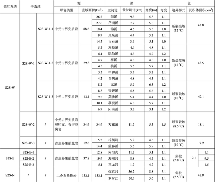
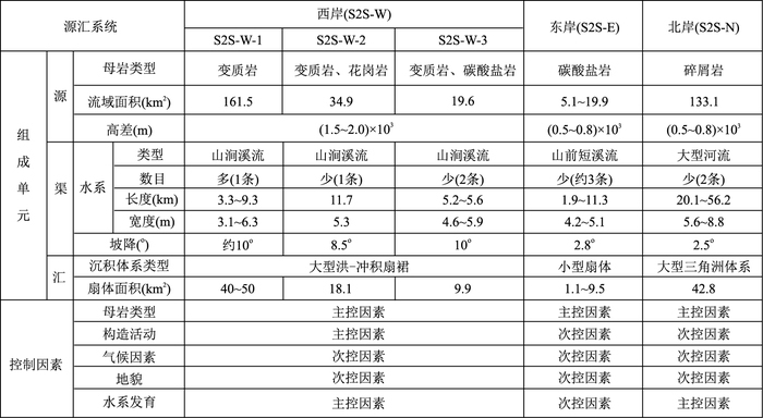
图 2 洱海现代湖盆西岸(S2S-W)、东岸(S2S-E)和北岸(S2S-N)地层特征
1.第四系砂土、细砂、粘土;2.二叠系茅口组灰岩夹角砾状灰岩;3.石炭系斗项山组白云质灰岩;4.泥盆系莲花曲组白云岩;5.泥盆系青山组灰岩;6.志留系青山组灰岩;7.志留系五福山组白云岩\白云质灰岩;8.志留系阴阳山组陆屑白云岩;9.中元古界苍山群茫涌溪岩组片岩及混合岩;10.中元古界苍山群龙泉峰岩组片岩基混合岩;11.燕山早期斜长花岗岩;12.印支期二长花岗岩
Fig. 2. Strata characteristics of the S2S-W, S2S-E, and S2S-N for the western, eastern, and northern parts of the modern Lake Erhai basin
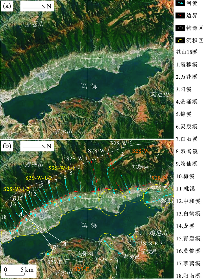
图 3 洱海现代湖盆西岸(S2S-W)、东岸(S2S-E)和北岸(S2S-N)源-汇系统特征
Fig. 3. Characteristics of the S2S-W, S2S-E, and S2S-N for the western, eastern, and northern parts of the modern Lake Erhai basin
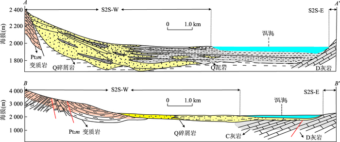
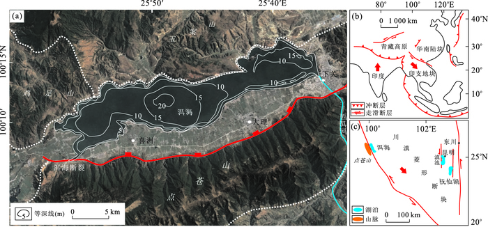
图 5 洱海现代湖盆东、西两岸源-汇系统剖面
剖面位置见图 3
Fig. 5. Sections of S2S-W and S2S-E for the western and eastern parts of the modern Lake Erhai basin
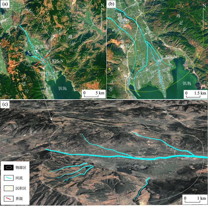
图 7 洱海现代湖盆北岸源-汇系统(S2S-N)特征
Fig. 7. Characteristics of S2S-N for the northern part of the modern Lake Erhai Basin
-
Allen, P.A., 2005.Striking a Chord.Nature, 434(7036):961. doi: 10.1038/434961a Allen, P.A., 2008a.From Landscapes into Geological History.Nature, 451:274-276. doi: 10.1038/nature06586 Allen, P.A., 2008b.Time Scales of Tectonic Landscapes and Their Sediment Routing Systems.Geological Society London Special Publications, 296(1):7-28.doi: 10.1144/SP296.2. Allen, P.A., Densmore, A.L., 2000.Sediment Flux from an Uplifting Fault Block.Basin Reserarch, 12:367-380. doi: 10.1046/j.1365-2117.2000.00135.x Allen, P.A., Hovius, N., 1998.Sediment Supply from Landslide-Dominated Catchments:Implications for Basin-Margin Fans.Basin Research, 10:19-35. doi: 10.1046/j.1365-2117.1998.00060.x Chen, A.D., Gu, J.N., Zhao, Z.Z., et al., 2016.Quartz Grains SEM Surface Microtextures of Quaternary Glacier Sediments along the Diancang Mountain in Yunnan, Southwest China.Journal of Glaciology and Geocryology, 38(2):453-462 (in Chinese with English abstract).doi: 10.7522/J.Issn.1000-0240.2016.0051. Dai, A., Qian, T.T., Trenberth, K.E., et al., 2009a.Change in Continental Freshwater Discharge from 1948 to 2004.Journal of Climate, 22:2773-2792. doi: 10.1175/2008JCLI2592.1 Dearing, J.A., Jones, R.T., 2003.Coupling Temporal and Spatial Dimensions of Global Sediment Flux through Lake and Marine Sediment Records.Global Planet.Change, 39:147-168. https://core.ac.uk/display/1468209 Dearing, J.A., Jones, R.T., Shen, J., et al., 2008.Using Multiple Archives to Understand Past and Present Climate-Human-Environment Interactions:The Lake Erhai Catchment, Yunnan Province, China.Journal of Paleolimnology, 40:3-31.doi: 10.1007/s10933-007-9182-2 Ding, W.R., 2016.A Study on the Characteristics of Climate Change around the Erhai Area, China.Resources and Environment in the Yangtze Basin, 25(4):599-605 (in Chinese with English abstract).doi: 10.11870/cjlyzyyhj201604009 Feng, Z.G., Wang, S.J., Liu, X.M., et al., 2009.Impact of Acid-Insoluble Residua of Carbonate Rocks on Developing Intensities of Their Weathering Crusts.Acta Geologica Sinca, 83(6):886-893 (in Chinese with English abstract). doi: 10.1007/s11430-014-4983-4 Galloway, W.E., 2001.Cenozoic Evolution of Sediment Accumulation in Deltaic and Shore-Zone Depositional Systems, Northern Gulf of Mexico Basin.Marine and Petroleum Geology, 18:1031-1040.doi:18(2001)1031-1040 Galloway, W.E., Ganey-Curry, P.E., Li, X., et al., 2000.Cenozoic Depositional History of the Gulf of Mexico Basin.AAPG Bulletin, 84:1743-1774. Gong, W., Jiang, X.D., 2017.Thermal Evolution History and Its Genesis of the Ailao Shan-Red River Fault Zone in the Ailao Shan and Day Nui Con Voi Massif during Oligocene-Early Miocene.Earth Science, 42 (2):223-239 (in Chinese with English abstract).doi: 10.3799/dqkx.2017.017 Gu, J.N., Chen, A.D., Zhao, Z.Z., et al., 2016.Quaternary Glacial Deposits Features and Its OSL Dating in Mt.Cangshan Global Geopark of Dali, Yunnan Province.Acta Geoscientica Sinica, 37(6):769-778 (in Chinese with English abstract).doi: 10.3975/cagsb.2016.06.12 Huang, H.J., Wang, Y.P., Li, Q.H., 2013.Climatic Characteristics over Erhai Lake Basin in the Late 50 Years and the Impact on Water Resources of Erhai Lake.Meteorological Monthly, 39(4):436-442 (in Chinese with English abstract).doi: 10.7519/j.issn.1000-0526.2013.04.005 Kang, H.L., Lin, C.S., Liu, X., et al., 2016.Syndepositional Fault Control on Types and Distribution of Depositional System and Lithologic Trap of Dongying Formation in the North of Nanpu Sag.Geoscience, 30(2):286-293 (in Chinese with English abstract). Kuang, M.S., Xie, S.Y., Zeng, Y., et al., 2002.Study on the Palaeovegetation and Palaeoclimate since Late Pleistocene in the Diancang Mountain Area in Dali of Yunnan Province.Journal of Southwest China Normal University (Natural Science), 27(5):759-765 (in Chinese with English abstract). Leloup, P.H., Harrison, T.M., Ryerson, F.J., et al., 1993.Structural Petrological and Thermal Evolution of a Tertiary Ductile Strike-Slip Shear Zone Diancang Shan, Yunnan.Journal of Geophysical Research, 98(B4):6715-6743. doi: 10.1029/92JB02791 Lai, F.Y., 1989.Relationship between Bedrock Lithology and Soil Erosion.China Soil and Water Conservation, 7:41-43(in Chinese). Li, B.L., Ji, J.Q., Luo, Q.H., et al., 2012.The Structural Style and Timing of Uplift of the Ailaoshan-Diancang Range, West Yunnan, China.Seismology and Geology, 34(4):697-709 (in Chinese with English abstract).doi: 10.3969/j.issn.0253-4967.2012.04.013 Li, K., Liu E.F., Zhang, E.L., et al., 2017.Historical Variations of Atmospheric Trace Metal Pollution in Southwest China:Reconstruction from a 150-Year Lacustrine Sediment Record in the Erhai Lake.Journal of Geochemical Exploration, 172:62-70.doi: 10.1016/j.gexplo.2016.10.009 Li, M.Q., Zhang, Z.R., Wang, Z.Y., et al., 2005.Tracing the Pedogenic Process to Carbonate Rocks in Light of Maceral and Microfabric Characteristics of Clay and Carbonate Rocks:A Case Study of Dashandong at Guiyang Rock-Clay Profile.Earth and Environment, 33(4):77-82 (in Chinese with English abstract). Li, S.T., 2015.Advance, Trend and New Challenges in Basin Geodynamics.Earth Science Frontiers, 22(1):1-8 (in Chinese with English abstract).doi: 10.13745/j.esf.2015.01.001. Li, S.H., Deng, C.L., Paterson, G.A., et al., 2014.Tectonic and Sedimentary Evolution of the Late Miocene-Pleistocene Dali Basin in the Southeast Margin of the Tibetan Plateau:Evidences from Anisotropy of Magnetic Susceptibility and Rock Magnetic Data.Tectonophysics, 629:362-377.doi: 10.1016/j.tecto.2014.05.035 Liu, Q.H., Cui, B., 2011.Impacts of Climate Change/Variablility on the Stream Flow in the Yellow River Basin, China.Ecological Modelling, 222:268-274. doi: 10.1016/j.ecolmodel.2009.11.022 Liu, Q.H., Zhu, H.T., Shu, Y., et al., 2015.Provenance Systems and Their Control on the Beach Bar of Paleogene Enping Formation, Enping Sag, Pearl River Mouth Basin.Acta Petrolei Sinica, 36(3):286-299 (in Chinese with English abstract).doi: 10.7623/syxb201503004 Liu, Q.H., Zhu, X.M., Li, S.L., et al., 2016.Pre-Palaeogene Bedrock Distribution and Source-to-Sink System Analysis in the Shaleitian Uplift.Earth Science, 41(11):1935-1950 (in Chinese with English abstract).doi: 10.3799/dqkx.2016.134 Liu, J.L., 2012.The Development and Landscape Application of Wild Flower Resources in Kunming, Yuan Mountain.Modern Gardening, (8):197-198 (in Chinese with English abstract).doi: 10.1405/j.cnki.xdyy.2012.08.096 Lu, H.B., Chen, G.J., Cai, Y.F., et al., 2016.Cladoceran Community Responses to Eutrophication, Fish Introduction and Macrophyte Degradation over the Past Centyry in Lake Erhai.Journal of Lake Science, 28(1):132-140 (in Chinese with English abstract).doi: 10.18307/2016.0115 Lu, X.X., 2004.Vulnerability of Water Discharge of Large Chines Rivers to Environmental Changes:An Overview.Regional Environmental Change, 4:182-191. doi: 10.1007/s10113-004-0080-0 Luo, R.J., Wu, Z.H., Huang, X.L., 2015.The Main Active Faults and the Active Tectonic System of Binchuan Area, Northwestern Yunnan.Geological Bulletin of China, 34(1):155-170 (in Chinese with English abstract). Meng, Y.F., Guo, X.G., Qian, T.J., 2008.Investigation on Ectoparasitic Sucking Lice on Small Mammals in Jizu Mountain, Yunnan.Journal of Pathogen Biology, 3(7):531-533 (in Chinese with English abstract).doi: 10.13350/j.cjpb.2008.07.002 Mo, Y.F., Xiao, X.S., 2010.Carbonate Rock Lithological Distribution by Remote Sensing Data for Areas with Flourishing Vegetation.Journal of Guilin University of Technology, 30(1):41-46 (in Chinese with English abstract). Pei, J.G., Liang, M.Z., Chen, Z., 2008.Classification of Karst Groundwater System and Statistics of the Main Characteristic Values in Southwest China Karst Mountain.Carsologica Sinica, 27(1):6-10 (in Chinese with English abstract). Peng, G., Jiao, W.Q., 1991.Radiocarbon Dating of Late Quaternary Sediments in Erhai Lake Basin of Dali Area and Evolution of the Erhai Lake.Seismology and Geology, 13(2):179-183 (in Chinese with English abstract). doi: 10.1007/BF02883214 Royden, L.H., Burchfiel, B.C., King, R.W., et al., 1997.Surface Deformation and Lower Crustal Flow in Eastern Tibet.Science, 276:788-790. doi: 10.1126/science.276.5313.788 Ruan, F.S., Zhou, F.J., 1995.Several Key Problems about Rebuilding Vegetation on Eroded Granite Slope.Journal of Soil and Water Conservation, 9(2):19-25 (in Chinese with English abstract). Shi, C., Zhou, Y., Fan, X., et al., 2012.A Study on the Annual Runoff Change and Its Relationship with Water and Soil Conservation Practices and Climate Change in the Middle Yellow River Basin.Catena, 100:31-41. Shen, J., Jones, R.T., Yang, X.D., et al., 2006.The Holocene Vegetation History of Lake Erhai, Yunnan Province Southwestern China:The Role of Climate and Human Forcings.Holocene, 16:265-276. doi: 10.1191/0959683606hl923rp Socquet, A., Pubellier, M., 2005.Cenozoic Deformation in Western Yunnan (China-Myanmar Border).Journal of Asian Sciences, 24:495-515.doi: 10.1016/j.jseaes.2004.03.006 Sømme, T.O., Helland-Hansen, W., Martinsen, O.J., et al., 2009a.Relationships between Morphological and SedimentologicalParameters in Source-to-Sink Systems:A Basis for Predicting Semi-Quantitative Characteristics in Subsurface Systems.Basin Research, 21(4):361-387.doi: 10.1111/j.1365-2117.2009.00397.X Sømme, T.O., Jackson, C.A.L., 2013a.Source-to-Sink Analysis of Ancient Sedimentary Systems Using a Subsurface Case Study from the Møre-Trøndelag Area of Southern Norway:Part 2-Sediment Dispersal and Forcing Mechanisms.Basin Research, 25(5):512-531. doi: 10.1111/bre.2013.25.issue-5 Sømme, T.O., Jackson, C.A.L., Vaksdal, M., 2013b.Source-to-Sink Analysis of Ancient Sedimentary Systems Using a Subsurface Case Study from the Møre-Trøndelag Area of Southern Norway:Part 1-Depositional Setting and Fan Evolution.Basin Research, 25(5):489-511.doi: 10.1111/bre.12014 Sømme, T.O., Martinsen, O.J., Thurmond, J.B., 2009b.Reconstructing Morphological and Depositional Characteristics in Subsurface Sedimentary Systems:An Example from the Maastrichtian-Danian Ormen Lange System, Møre Basin, Norwegian Sea.AAPG Bulletin, 93(10):1347-1377.doi: 10.1306/0601090938 Su, D.D., Wu, Z.L., Gao, J.Y., et al., 2014.Comparison of Understory Bird Communities in Evergreen Broadleaved Forests of Daweishan and Jizushan, Yunnan, China.Chinese Journal of Ecology, 33(1):132-140 (in Chinese with English abstract). http://d.wanfangdata.com.cn/Periodical/stxzz201401020 Su, J.L., Li, J., Yang, G.R., et al., 2015.Comparative Analysis Hourly Precipitation Features on the East and West Sides of Yunling Diancang Mountain in Hengduan Mountains.Meteorological Monthly, 41(1):17-24 (in Chinese with English abstract). Tapponnier, P., Lacassin, R., Leloup, P.H., et al., 1990.The Ailao Shan/Red River Metamorphic Belt:Tertiary Left-Lateral Shear between Indochina and South China.Nature, 343(1):431-437. http://www.oalib.com/references/19210310 Tian, Q., 2016.Impacts of Climate Change and Human Activity on the Water and Sediment Flux of the Yellow, Yangtze and Pearl River Basins Over the Past 60 Years(Dissertation).East China Normal University, Shanghai (in Chinese with English abstract). Trenberth, K.E., Fasullo, J.T., Mackaro, J., 2011.Atmospheric Moisture Transports from Ocean to Land and Global Energy Flows in Reanalyses.Journal of Climate, 24:4907-4924. doi: 10.1175/2011JCLI4171.1 Wagener, T., Liu, Y., Cupta, H.V., et al., 2005.Regional Hydrological Impacts of Climate Change:Impact Assessment and Decision Making.IAHS Press, Centre for Ecology and Hydrology, UK, 163. Wan, Y., Han, T.D., Duan, C.Q., et al., 2005.Landform System Structures and Characteristics of the Diancang Mountain Areas in West Yunnan Province.Journal of Glaciology and Geocryology, 27(2):241-248 (in Chinese with English abstract). doi: 10.1007/s11430-007-0114-9 Wang, E., Burchfiel, B.C., Royden, L.H., et al., 1998.Late Cenozoic Xianshuihe-Xiaojiang, Red River, and Dali Fault Systems of Southwestern Sichuan and Central Yunnan, China.Geological Society of American, Special Paper, 327:1-108. doi: 10.1007/s11430-011-4231-0 Wang, E.Q., Fan, C., Wang, G., et al., 2006.Deformational and Geomorphic Progresses in the Formation of the Ailaoshan-Diancang Range, West Yunnan.Quaternary Sciences, 26(2):220-228 (in Chinese with English abstract). Wang, S.J., 2002.Concept Deduction and Its Connotation of Karst Rocks Desertification.Carsologica Sinica, 21(2):101-105 (in Chinese with English abstract). doi: 10.11821/dlxb201511001 Wang, X.L., Jiang, G.Q., Zhou, W., et al., 2016.TMDL of Lake Erhai Based on Water Ecological Features.Journal of Lake Sciences, 28(2):271-280 (in Chinese with English abstract).doi: 10.18307/2016.0205 Wang, X.H., Yu, S., Huang, G.H., 2004.Land Allocation Based on Integrated GIS-Optimization Modeling at a Watershed Level.Landscape and Urban Planning, 66:61-74.doi: 10.1016/S0169-2046(03)00095-1 Xu, C.H., Du, X.F., Xu, W., et al., 2017.New Advance of the "Source-to-Sink" System Research in Sedimentary Basin.Oil and Gas Geology, 38(1):1-11 (in Chinese with English abstract). Xu, H., Zhou, X.Y., Lan, J.H., et al., 2015.Late Holocene Indian Summer Monsoon Variations Recorded at Lake Erhai, Southwestern China.Quaternary Research, 83:307-314.doi: 10.1016/j.yqres.2014.12.004 Xu, L.J., Liu, Z.H., Cao, J., 2014.Numerical Simulation of Local Circulation over the Cangshan Mountain-Erhai Lake Area in Dali, Southwest China.Chinese Journal of Atmospheric Sciences, 38(6):1198-1210 (in Chinese with English abstract).doi: 10.3878/j.issn.1006-9895.1401.13293 Yang, C.Y., Yang, G.B., Chen, Z.H., 2016.Analysis of Vgetation Cover under the Background of Different Lithology Characteristics in the Mountainous Area in Southwest of China-A Case Study of Panxian.Journal of Guizhou Normal University (Natural Sciences), 34(6):1-7(in Chinese with English abstract).doi: 10.16614/j.cnki.issn1004-5570.2016.06.001. Yang, L.Z., 1985.Distribution of Subterranean Rivers in South China.Carsologica Sinica, 4(1-2):92-100 (in Chinese with English abstract). You, M.Y., Qin, R.G., Cao, G.Z., et al., 2016.Heterogeneous Distribution of the Aquifer Sediments in an Alluvial Fan of Dali, Yunnan.Geology and Exploration, 52(4):734-742 (in Chinese with English abstract).doi: 10.13712/j.cnki.dzyki.2016.04.015 Zhao, C.Q., Zhao, L., Cao, S.Y., et al., 2014.Cenozoic Deformation-Metamorphic Evolution of the Diancang Shan Metamorphic Complex and Regional Tectonic Implications.Acta Petrologica Sinica, 30(3):852-866 (in Chinese with English abstract). http://d.wanfangdata.com.cn/Periodical/ysxb98201403023 Zhao, H.C., Wang, S.R., Jiao, L.X., et al., 2013.Characteristics of Composition and Spatial Distribution of Organic Matter in the Sediment of Erhai Lake.Research of Environmental Sciences, 26(3):243-249 (in Chinese with English abstract). Zhang, H., Sun, S.M., Ji, H.C., et al., 2016.Segmentation Characteristic of Boundary Fault in Nanpu Sag and Its Control on Sedimentary System.Petroleum Geology and Recovery Efficiency, 23(3):20-25 (in Chinese with English abstract).doi: 10.13673/j.cnki.cn37-1359/te.2016.03.004 Zhang, Q., Wan, Y., Zeng, H.Y., 2016.Progress, Discuss and Prospects of Dali Glaciation on Massif Diancang.Yunnan Geographic Environment Research, 28(1):22-29 (in Chinese with English abstract). http://www.academia.edu/10879784/Geomorphological_Heritage_and_Landscape_Enhancement Zhang, S.J., Qi, Q.J., Wang, S.R., et al., 2011.Effects of Organic Matter, Manganese and Iron on Phosphorus Fractions and Release in the Sediments of Erhai Lake.Research of Environmental Sciences, 24(4):371-378 (in Chinese with English abstract). Zhou, J.C., 1987.Investigation on Modern Sediments of Faults Lakes in Yunnan Province.Xinjiang Petroleum Geology, 8(1):60-63(in Chinese). Zhou, Y.T., Huang, R.H., 2010.Interdecadal Variability of Summer Rainfall in Northwest China and Its Possible Causes.International Journal of Climatology, 30:549-557. https://www.cabdirect.org/cabdirect/abstract/20103133471 Zhou, J.Y., Wu, C.L., Li, X., et al., 2000.Dynamic Mechanism and Fractal Simulation of Growth Process of Fan-Shaped Sedimentary Bodies.Earth Science, 25(1):33-38 (in Chinese with English abstract). Zhu, H.H, 1991.Formation of Fault Lakes in Yunnan Province, and Its Sediment and Evolution in Lake Cenozoic.Oceanology et Limnologia Sinica, 22(6):509-516 (in Chinese with English abstract). Zhu, H.H., Yao, B.H., 1989.Study on the Delta Deposition in Fault Lakes, Yunnan Province, and Its Significance for Petroleum Exploration.Oil and Gas Geology, 10(2):95-106 (in Chinese with English abstract). http://www.academia.edu/6572415/Seismic_Expression_and_Geological_Significance_of_a_Lacustrine_Delta_in_Neogene_Deposits_of_the_Western_Snake_River_Plain_Idaho1 Zhu, H.T., Yang, X.H., Zhou, X.H., et al., 2013.Sediment Transport Pathway Characteristics of Continental Lacustrine Basin Based on 3-D Seismic Data:An Example from Dongying Formation of Western Slope of Bozhong Sag.Earth Science, 38(1):121-129 (in Chinese with English abstract).doi: 10.3799/dqks.2013.012 Zhu, X.M., Zhong, D.K., Yuan, X.J., 2016.Development of Sedimentary Geology of Petroliferous Basins in China.Petroleum Exploration and Development, 43(5):820-829 (in Chinese with English abstract).doi: 10.11698/PED.2016.05.20 陈安东, 顾佳妮, 赵志中, 等, 2016.云南大理点苍山末次冰期冰碛物石英砂扫描电镜形态特征分析.冰川冻土, 38(2):453-462. http://d.wanfangdata.com.cn/Periodical/bcdt201602020 丁文荣, 2016.环洱海地区气候变化特征研究.长江流域资源与环境, 25(4):599-605. http://d.wanfangdata.com.cn/Periodical/cjlyzyyhj201604009 冯志刚, 王世杰, 刘秀明, 等, 2009.酸不溶物对碳酸盐岩风化壳发育程度的影响.地质学报, 83(6):886-893. http://d.wanfangdata.com.cn/Periodical/dizhixb200906016 宫伟, 姜效典, 2017.哀牢山-红河断裂带哀牢山-大象山段渐新世-早中新世热史演化及成因.地球科学, 42(2):223-239. http://earth-science.net/WebPage/Article.aspx?id=3430 顾佳妮, 陈安东, 赵志中, 等, 2016.大理苍山世界地质公园第四纪冰碛物特征及年代测定.地球学报, 37(6):769-778. doi: 10.3975/cagsb.2016.06.12 黄慧君, 王永平, 李庆红, 2013.洱海流域近50年气候变化特征及其对洱海水资源的影响.气象, 39(4):436-442. doi: 10.7519/j.issn.1000-0526.2013.04.005 康海亮, 林畅松, 刘晓, 等, 2016.南堡凹陷北部东营组同沉积断裂对沉积体系及岩性圈闭的控制作用.现代地质, 30(2):286-293. http://d.wanfangdata.com.cn/Periodical/xddz201602004 况明生, 谢世友, 曾艳, 等, 2002.云南大理点苍山地区晚更新世以来的古植被和古气候.西南师范大学学报(自然科学版), 27(5):759-765. http://d.wanfangdata.com.cn/Periodical/xnsfdxxb200205029 赖发叶, 1989.试论母岩岩性与土壤侵蚀的关系.中国水土保持, 7:41-43. http://kns.cnki.net/KCMS/detail/detail.aspx?filename=zgsb198907018&dbname=CJFD&dbcode=CJFQ 李宝龙, 季建清, 罗清华, 等, 2012.滇西点苍山-哀牢山隆升构造样式和隆升时限.地震地质, 34(4):697-709. http://kns.cnki.net/KCMS/detail/detail.aspx?filename=dzdz201204016&dbname=CJFD&dbcode=CJFQ 李明琴, 张竹如, 王智勇, 等, 2005.用岩-土显微特征示踪碳酸盐岩母岩的成土过程——以贵阳市大山洞岩-土剖面为例.地球与环境, 33(4):77-82. http://kns.cnki.net/KCMS/detail/detail.aspx?filename=dzdq200504015&dbname=CJFD&dbcode=CJFQ 李思田, 2015.沉积盆地动力学研究的进展、发展趋向与面临的挑战.地学前缘, 22(1):1-8. http://d.wanfangdata.com.cn/Periodical/dxqy201501001 刘强虎, 朱红涛, 舒誉, 等, 2015.珠江口盆地恩平凹陷古近系恩平组物源体系及其对滩坝的控制.石油学报, 36(3):286-299. doi: 10.7623/syxb201503004 刘强虎, 朱筱敏, 李顺利, 等, 2016.沙垒田凸起前古近系基岩分布及源-汇过程.地球科学, 41(11):1935-1950. http://earth-science.net/WebPage/Article.aspx?id=3391 刘江丽, 2012.昆明玉案山野生花卉资源的开发及园林应用.现代园艺, (8):197-198. http://d.wanfangdata.com.cn/Periodical/jiangxyy201208169 卢慧斌, 陈光杰, 蔡燕凤, 等, 2016.近百年来枝角类群落响应洱海营养水平、外来鱼类引入以及水生植被变化的特征.湖泊科学, 28(1):132-140. doi: 10.18307/2016.0115 罗睿洁, 吴中海, 黄小龙, 等, 2015.滇西北宾川地区主要活动断裂及其活动构造体系.地质通报, 34(1):155-170. http://d.wanfangdata.com.cn/Periodical/zgqydz201501013 孟艳芬, 郭宪国, 钱体军, 2008.云南鸡足山小兽体表寄生吸虱状况调查.中国病原生物学杂志, 3(7):531-533. http://d.wanfangdata.com.cn/Periodical/zgjscbfzzz200807016 莫源富, 奚小双, 2010.植被覆盖茂密区碳酸盐岩岩性的遥感识别——以灌江流域为例.桂林理工大学学报, 30(1):41-46. http://d.wanfangdata.com.cn/Periodical/glgxy201001006 裴建国, 梁茂珍, 陈阵, 2008.西南岩溶石山地区岩溶地下水系统划分及其主要特征值统计.中国岩溶, 27(1):6-10. http://d.wanfangdata.com.cn/Periodical/zgyr200801002 彭贵, 焦文强, 1991.洱海湖盆晚第四纪地层的14C年龄测定及洱海的演变.地震地质, 13(2):179-183. http://kns.cnki.net/KCMS/detail/detail.aspx?filename=dzdz199102010&dbname=CJFD&dbcode=CJFQ 阮伏水, 周伏建, 1995.花岗岩侵蚀坡地重建植被的几个关键问题.水土保持学报, 9 (2):19-25. http://kns.cnki.net/KCMS/detail/detail.aspx?filename=trqs502.002&dbname=CJFD&dbcode=CJFQ 苏栋栋, 吴兆录, 高建云, 等, 2014.云南大围山和鸡足山常绿阔叶林林下鸟类群落比较.生态学杂志, 33(1):132-140. http://d.wanfangdata.com.cn/Periodical/stxzz201401020 苏锦兰, 李健, 杨桂荣, 等, 2015.横断山系云岭余脉点苍山东西侧小时降水特征对比分析.气象, 41(1):17-24. doi: 10.3969/2013jms.0049 田清, 2016. 近60年来气候变化和人类活动对黄河、长江、珠江水沙通量影响的研究(博士学位论文). 上海: 华东师范大学. http://cdmd.cnki.com.cn/Article/CDMD-10269-1016145817.htm 万晔, 韩添丁, 段昌群, 等, 2005.滇西名山点苍山地区地貌结构与特征研究.冰川冻土, 27(2):241-248. http://d.wanfangdata.com.cn/Periodical/bcdt200502014 王二七, 樊春, 王刚, 等, 2006.滇西哀牢山-点苍山形成的构造和地貌过程.第四纪研究, 26(2):220-228. http://d.wanfangdata.com.cn/Periodical/dsjyj200602009 王世杰, 2002.喀斯特石漠化概念演绎及其科学内涵的探讨.中国岩溶, 21(2):101-105. http://d.wanfangdata.com.cn/Periodical/zgyr200202006 王显丽, 姜国强, 周雯, 等, 2016.基于洱海水生态特征的流域最大日符合总量的控制.湖泊科学, 28(2):271-280. doi: 10.18307/2016.0205 徐长贵, 杜晓峰, 徐伟, 等, 2017.沉积盆地源-汇系统研究新进展.石油与天然气地质, 38(1):1-11. doi: 10.11743/ogg20170101 许鲁君, 刘辉志, 曹杰, 2014.大理苍山-洱海局地环流的数值模拟.大气科学, 38(6):1198-1210. http://kns.cnki.net/KCMS/detail/detail.aspx?filename=dqxk201406015&dbname=CJFD&dbcode=CJFQ 杨春艳, 杨广斌, 陈智虎, 2016.西南山区不同岩性背景下植被覆盖特征分析——以盘县为例.贵州师范大学学报(自然科学版), 34(6):1-7. http://kns.cnki.net/KCMS/detail/detail.aspx?filename=natr201606001&dbname=CJFD&dbcode=CJFQ 杨立铮, 1985.中国南方地下河分布特征.中国岩溶, 4(1-2):92-100. http://d.wanfangdata.com.cn/Thesis/Y1660832 由明宇, 覃荣高, 曹广祝, 等, 2016. 大理冲积扇含水层非均质性分布规律研究, 52(4): 734-742. 赵春强, 赵利, 曹淑云, 等, 2014.点苍山变质杂岩新生代变质-变形演化及其区域构造内涵.岩石学报, 30(03):852-866. http://d.wanfangdata.com.cn/Periodical/ysxb98201403023 赵海超, 王圣瑞, 焦立新, 等, 2013.洱海沉积物有机质及其组分空间分布特征.环境科学研究, 26(3):243-249. http://kns.cnki.net/KCMS/detail/detail.aspx?filename=hjkx201303005&dbname=CJFD&dbcode=CJFQ 章慧, 孙思敏, 季汉成, 等, 2016.南堡凹陷边界断层分段特征及其对沉积体系的控制作用.油气地质与采收率, 23(3):20-25. http://d.wanfangdata.com.cn/Periodical/yqdzycsl201603004 张全, 万晔, 曾洪云, 2016.点苍山大理冰期研究回顾、讨论与展望.云南地理环境研究, 28(1):22-29. http://d.wanfangdata.com.cn/Periodical/yndlhjyj201601004 张仕军, 齐庆杰, 王圣瑞, 等, 2011.洱海沉积物有机质、铁、锰对磷的赋存特征和释放的影响.环境科学研究, 24(4):371-378. http://kns.cnki.net/KCMS/detail/detail.aspx?filename=hjkx201104002&dbname=CJFD&dbcode=CJFQ 周经才, 1987.云南断陷湖盆现代沉积考察.新疆石油地质, 8(1):60-63. http://kns.cnki.net/KCMS/detail/detail.aspx?filename=xjsd198704010&dbname=CJFD&dbcode=CJFQ 周江羽, 吴冲龙, 李星, 等, 2000.扇形沉积体生长过程的动力学机制及分形模拟.地球科学, 25(1):33-38. http://earth-science.net/WebPage/Article.aspx?id=894 朱海虹, 1991.云南断陷湖泊的形成和晚新生代的沉积及其演化.海洋与湖沼, 22(6):509-516. doi: 10.1016-j.aim.2011.02.013/ 朱海虹, 姚秉衡, 1989.云南断陷湖泊三角洲沉积及其在石油勘探中的意义.石油与天然气地质, 10(2):95-106. doi: 10.11743/ogg19890201 朱红涛, 杨香华, 周心怀, 等, 2013.基于地震资料的陆相湖盆物源通道特征分析:以渤中凹陷西斜坡东营组为例.地球科学, 38(1):121-129. http://earth-science.net/WebPage/Article.aspx?id=2349 朱筱敏, 钟大康, 袁选俊, 等, 2016.中国含油气盆地沉积地质学进展.石油勘探与开发, 43(5):820-829. http://d.wanfangdata.com.cn/Periodical/syktykf201605020 -

 下载:
下载:
 点击查看大图
计量
- 文章访问数: 4473
- HTML全文浏览量: 2488
- PDF下载量: 76
- 被引次数: 0
