


Reconstruction of Discrete Gravity Data Using Three-Tier Equivalent Sources with Variable Sizes
-
摘要: 离散重力测量数据的重构是重力数据分析和处理中最重要的方法之一.等效源方法作为一种有效且稳定的重构方法,受到国内外学者的关注.基于位场理论,提出了三层变尺度等效源方法的技术方案,可有效恢复测量数据中长波长范围的信息,实现对离散重力数据的高精度重构,进而保障了在重力场重构基础上的重力梯度计算.详细地讨论了三层变尺度等效源的设置以及优化反演计算的过程,通过二维和三维理论模型试验,展示了方法的有效性及相对单层等效源方法的优势,并通过广西某地区实际重力测量数据的应用,验证了方法的抗噪能力和实用性.Abstract: Reconstruction of discrete gravity data is an important technique in data analysis and processing. As an effective and stable approach of reconstruction, Equivalent-source method has still been the interest of geoscientists. In this paper, the frame of multi-size equivalent-sources distributing in three layers is proposed based on the theory of potential field. This approach can effectively recover long-wavelength information in observed data and is able to realize the high-precision reconstruction, so that gravity gradients can be calculated accurately on the basis of the achieved equivalent-sources. Issues on settings of three-layer equivalent sources with variable sizes and the optimization of inversion algorithm are discussed in the work. The experiments of 2D and 3D models show the effectiveness and the advantage of the method relative to the reconstructed results using single-layer equivalent-source method. The real data example from a region of Guangxi, China, is applied and its result illustrates that the method has good noise suppression and practicability.
-
Key words:
- gravity /
- gravity gradient /
- reconstruction /
- three-tier equivalent sources /
- variable size
-
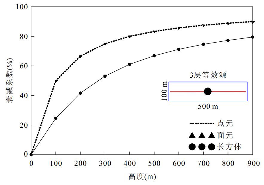
图 1 3种等效源单元体的重力效应衰减特征
Fig. 1. Gravity attenuation characteristics of three equivalent sources
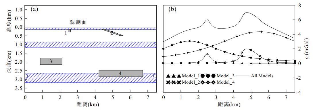
图 2 二维组合模型及其产生的重力效应
a.密度模型及多层等效源设置示意图,其中斜杠填充区域表示等效源分布区间;b.各模型理论重力异常及其总和
Fig. 2. 2D synthetic example and theoretical gravity anomaly
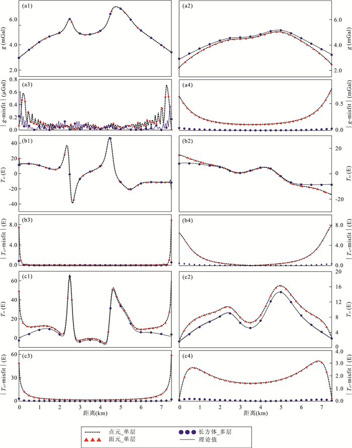
图 3 观测剖面及750 m高度上重构结果及其与理论值的拟合差分布
图中左列为各方法在观测面上重构重力和重力梯度及其与理论值的拟合差;右列为各方法在上延至750 m高度的重力和重力梯度及其与理论值的拟合差
Fig. 3. Reconstruction results and their difference relative to theoretical values on observation surface and on the altitude of 750 m
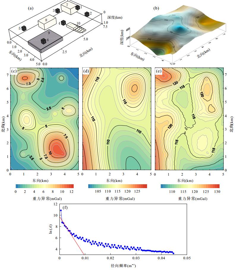
图 4 三维模型组合与观测面以及理论重力场
a.三维模型示意图;b.起伏的观测面;c.观测面上的理论重力场;d.观测面上背景场;e.含噪声的模型重力场与背景场之和;f.对数功率谱曲线
Fig. 4. 3D synthetic example, observation surface and theoretical gravity anomaly
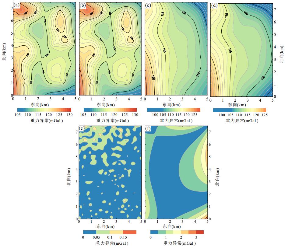
图 5 三维模型及背景理论重力场及其重构结果
a.无噪声理论模型与背景场;b.用图 4e重构的观测面重力场;c.h=1 000 m平面上的理论模型与背景场;d.用图 4e重构的h=1 000 m平面上结果;e.观测面上重构重力值与理论值拟合差;f.h=1 000 m平面上重构重力值与理论值拟合差
Fig. 5. The gravity field from non-noise 3D models and background and reconstructive results

图 6 三维模型重构计算(Rec)的重力梯度结果与理论值比较
左侧(1, 2)两列为起伏观测面上重构后计算(Rec)的重力梯度及其理论值;右侧(3, 4)两列为420 m高度上重构计算的(Rec)重力梯度及其理论值;a、b与c分别为Txz(北向水平梯度),Tyz(东向水平梯度)和Tzz(垂向梯度);图例单位为:重力值(mGal)
Fig. 6. Comparison between the reconstruction gravity gradients and theoretical values of 3D models and background fields
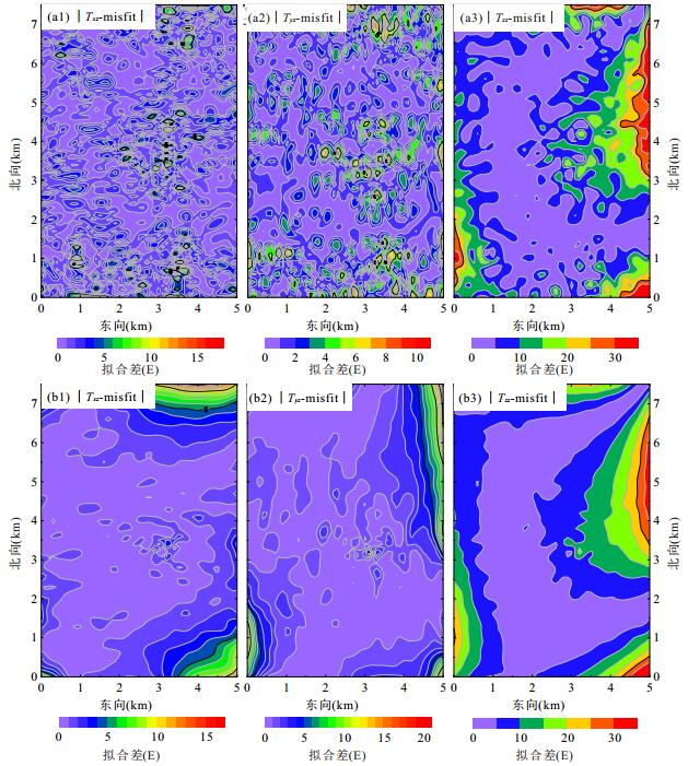
图 7 三维模型重力梯度重构结果与理论值拟合差
a、b分别表示观测面上与420 m高度上拟合差,(1~3)分别表Txz(北向水平梯度)、Tyz(东向水平梯度)和Tzz(垂向梯度)
Fig. 7. Difference between the reconstruction gravity gradients and theoretical values of 3D models and background fields

图 8 研究区地形、实测重力异常与重构结果
a.研究区地形等高线;b.实测重力异常;c.重构起伏地面上重力异常;d.重构海拔910 m平面上重力异常;e.对数功率谱曲线
Fig. 8. Topography, observed gravity anomaly and reconstructive results in study area
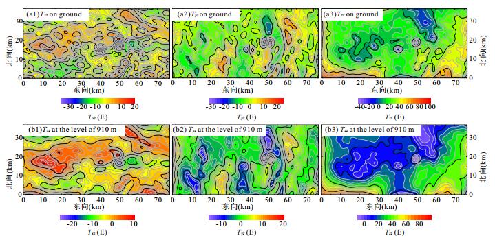
图 9 重构的重力梯度
a1、a2和a3分别为观测面上Txz(北向水平梯度),Tyz(东向水平梯度)和Tzz(垂向梯度);b1、b2和b3分别为上延至海拔910 m平面上的Txz, Tyz和Tzz
Fig. 9. Reconstructive gravity gradients
表 1 模型参数设置
Table 1. Designed parameters of models
模型编号 模型形状 模型中心距高程h=0
处平面深度(km)密度
(103 kg/m3)1 小方块 0.140 1.5 2 小方块 0.140 1.5 3 小方块 0.115 1.5 4 小方块 0.050 1.5 5 小方块 0.100 1.5 6 小方块 0.170 1.5 7 长方柱体 0.300 1.0 8 长方柱体 0.550 1.0 9 板状体 0.650 2.0 10 倾斜板状体 0.500 1.0  下载: 导出CSV
-
Barnes, G., Lumley, J., 2011.Processing Gravity Gradient Data.Geophysics, 76(2):133-147. https://doi.org/10.1190/1.3548548 Bhattacharyya, B.K., Chan, K.C., 1977.Reduction of Magnetic and Gravity Data on an Arbitrary Surface Acquired in a Region of High Topographic Relief.Geophysics, 42(7):1411-1430. https://doi.org/10.1190/1.1440802 Chen, J.L., Zhang, Y., Chen, C., 2010.Satellite Magnetic Anomaly and Regional Geological Characteristics in Guangxi Area.Chinese Journal of Engineering Geophysics, 7(3):327-332(in Chinese with English abstract). Dampney, C.N.G., 1969.The Equivalent Source Technique.Geophysics, 34(1):39-53. https://doi.org/10.1190/1.1439996 Feng, J.F., 2016.Extraction and Explanation of Gravity and Magnetic Anomaly Features in Shedong Area of Guangxi(Dissertation).China University of Geosciences, Wuhan (in Chinese with English abstract). Guo, Z.H., Guan, Z.N., Xiong, S.Q., 2004.Cuboid ΔT and Its Gradient Forward Theoretical Expressions without Analytic Odd Points.Chinese Journal of Geophysics, 47(6):1131-1138(in Chinese with English abstract). doi: 10.1007/978-3-642-21815-6_9/fulltext.html Hansen, R.O., Miyazaki, Y., 1984.Continuation of Potential Fields between Arbitrary Surfaces.Geophysics, 49(6):787-795. https://doi.org/10.1190/1.1441707 Klees, R., Tenzer, R., Prutkin, I., et al., 2008.A Data-Driven Approach to Local Gravity Field Modelling Using Spherical Radial Basis Functions.Journal of Geodesy, 82(8):457-471. https://doi.org/10.1007/s00190-007-0196-3 Leão, J.W.D., Silva, J.B.C., 1989.Discrete Linear Transformations of Potential Field Data.Geophysics, 54(4):497-507. https://doi.org/10.1190/1.1442676 Li, S., Liu, C.C., Jiang, Y.L., 2015.Application of 3D Equivalent Source Inversion and Imaging.Coal Geology & Exploration, 43(5):90-94 (in Chinese with English abstract). Li, Y.G., Oldenburg, D.W., 1996.3-D Inversion of Magnetic Data.Geophysics, 61(2):394-408. https://doi.org/10.1190/1.1443968 Li, Y.G., Oldenburg, D.W., 1998.3-D Inversion of Gravity Data.Geophysics, 63(1):109-119. https://doi.org/10.1190/1.1444302 Li, Y.G., Oldenburg, D.W., 2000.Reduction to the Pole Using Equivalent Sources.SEG Technical Program Expanded Abstracts 2000, Technical Program Expanded Abstracts, 19(1):2484-2484. https://doi.org/10.1190/1.1816074 Li, Y.G., Oldenburg, D.W., 2001.Stable Reduction to the Pole at the Magnetic Equator.Geophysics, 66(2):571-578. https://doi.org/10.1190/1.1444948 Li, Y.G., Oldenburg, D.W., 2010.Rapid Construction of Equivalent Sources Using Wavelets.Geophysics, 75(3):L51-L59. https://doi.org/10.1190/1.3378764 Liu, S., Feng, J., Gao, W.L., et al., 2013.2D Inversion for Borehole Magnetic Data in the Presence of Significant Remanence and Demagnetization.Chinese Journal of Geophysics, 56(12):4297-4309(in Chinese with English abstract). Liu, T.Y., Yang, Y.S., Li, Y.Y., et al., 2007.The Order-Depression Solution for Large-Scale Integral Equation and Its Application in the Reduction of Gravity Data to a Horizontal Plane.Chinese Journal of Geophysics, 50(1):290-296(in Chinese with English abstract). http://www.oalib.com/paper/1567950 Ma, G.Q., Ming, Y.B., He, Y., et al., 2016.Horizontal Derivative Iteration Method for Downward Continuation of Gravity and Magnetic Data.Earth Science, 41(7):1231-1237 (in Chinese with English abstract). MacLennan, K., Li, Y.G., 2013.Denoising Multicomponent CSEM Data with Equivalent Source Processing Techniques.Geophysics, 78(3):E125-E135. https://doi.org/10.1190/geo2012-0226.1 Mendonça, C.A., Silva, J.B.C., 1994.The Equivalent Data Concept Applied to the Interpolation of Potential Field Data.Geophysics, 59(5):722-732. https://doi.org/10.1190/1.1443630 Nagy, D., 1966.The Gravitational Attraction of a Right Rectangular Prism.Geophysics, 31(2):362-371. https://doi.org/10.1190/1.1439779 Needham, P.E., 1970.The Formation and Evaluation of Detailed Geopotential Models Based on Point Masses.Report 149.Department of Geodetic Science and Surveying, Ohio State University, Ohio. Oliveira, Jr., V.C., Barbosa, V.C.F., 2013.Polynomial Equivalent Layer.Geophysics, 78(1):G1-G13. https://doi.org/10.1190/geo2012-0196.1 Pang, X.L., 2012.Research on Reduction of Aeromagnetic Anomalies by Means of Equivalent Source Technology (Dissertation).China University of Geosciences, Beijing (in Chinese with English abstract). Pang, X.L., Yao, C.L., Zheng, Y.M., et al., 2010.The Technique of the Altitude Correction on Aeromagnetic Data.In:Chinese Geophysical Society, Seismological Society of China, eds., The Chinese Geophysics 2010-Proceedings of the Twenty-Sixth Annual Conference of the Chinese Geophysical Society and the Thirteenth Academic Conference of the Chinese Seismological Society.Seismological Press, Beijing, 631 (in Chinese). Pang, X.L., Yao, C.L., Zheng, Y.M., et al., 2011.The Improvements of the Technique of the Altitude Correction on Aeromagnetic Data.In:Chinese Geophysical Society, ed., Proceedings of the Twenty-Seventh Annual Conference of the Chinese Geophysical Society.University of Science and Technology of China Press, Hefei, 697 (in Chinese). Pilkington, M., 1997.3-D Magnetic Imaging Using Conjugate Gradients.Geophysics, 62(4):1132-1142. https://doi.org/10.1190/1.1444214 Sun, S.D., Chen, C., Du, J.S., et al., 2016.Magnetic Characteristics and Tectonic Implications of Crust in Junggar Basin and Its Surroundings.Earth Science, 41(7):1216-1224 (in Chinese with English abstract). Sünkel, H., 1981.Point Mass Models and the Anomalous Gravitational Feld.Report 328.Department of Geodetic Sciences, Ohio State University, Columbus. Syberg, F.J.R., 1972.A Fourier Method for the Regional-Residual Problem of Potential Fields.Geophysical Prospecting, 20(1):47-75.https://doi.org/10.1111/j.1365-2478.1972.tb00619.x doi: 10.1111/gpr.1972.20.issue-1 Vermeer, M., 1991.Geoid Recovery at 0.5 Degree Resolution from Global Satellite Gradiometry Data Sets.International Association of Geodesy Symposia, 18-29. https://doi.org/10.1007/978-1-4612-3104-2_5 Wang, W.Y., Pan, Z.S., 1996.Data Processing and Transformation Methods of Potential Fields on an Arbitray Surface with Dipole Layer Potential Technique.Journal of Xi'an College of Geology, 18(3):69-76 (in Chinese with English abstract). https://www.sciencedirect.com/science/article/pii/B9780444638908000347 Wang, W.Y., Pan, Z.S., Li, J.K., 1991.Continuation Methods for Curved Surface of the Three-Dimensional High-Precision Gravity and Magnetic Potential Field.Geophysical & Geochemical Exploration, 15(6):415-422 (in Chinese with English abstract). Wei, H.P., 2014.The Equivalent Source Method in Weak Gravity and Magnetic Information on Research and Application in Separation(Dissertation).Chengdu University of Technology, Chengdu (in Chinese with English abstract). Wu, X.P., 1984.Point-Mass Model of Local Gravity Field.Acta Geodetica et Cartographica Sinica, 13(4):250-258 (in Chinese with English abstract). Xia, J., Sprowl, D.R., 1991.Correction of Topographic Distortion in Gravity Data.Geophysics, 56(4):537-541. https://doi.org/10.1190/1.1443070 Xie, R.K., Wang, P., Duan, S.L., et al., 2015.Analysis of the Reduction of Aeromagnetic Gradients Data to a Horizontal Plane.Progress in Geophysics, 30(6):2836-2840 (in Chinese with English abstract). Xu, S.Z., Shen, X.H., Zou, L.J., et al., 2004.Downward Continuation of Aeromagnetic Anomaly from Flying Altitude to Terrain.Chinese Journal of Geophysics, 47(6):1127-1130(in Chinese with English abstract). Zhao, D.M., 2001.Research on the Fast Approximation of Ballistic Missile Disturbing Gravity(Dissertation).Information Engineering University, Zhengzhou (in Chinese with English abstract). Zhu, G.Q., Li, H.L., Wen, R.X., 2011.Prediction and Analysis of Deep Mineral Exploration in Guangxi.Chinese Journal of Engineering Geophysics, 8(6):713-722(in Chinese with English abstract). doi: 10.1007/s11771-009-0164-6 陈家联, 张毅, 陈超, 2010.广西地区卫星磁异常与区域地质特征.工程地球物理学报, 7(3):327-332. http://www.cnki.com.cn/Article/CJFDTOTAL-WTYH200305001.htm 冯建辉, 2016. 广西社垌地区重磁异常特征提取与解释(硕士学位论文). 武汉: 中国地质大学. 郭志宏, 管志宁, 熊盛青, 2004.长方体ΔT场及其梯度场无解析奇点理论表达式.地球物理学报, 47(6):1131-1138. http://www.cqvip.com/Main/Detail.aspx?id=11420770 黎莎, 刘春成, 江玉乐, 2015.三维等效源反演成像研究及应用.煤田地质与勘探, 43(5):90-94. http://industry.wanfangdata.com.cn/dl/Detail/Periodical?id=Periodical_mtdzykt201505021 刘双, 冯杰, 高文利, 等, 2013.强剩磁强退磁条件下的二维井中磁测反演.地球物理学报, 56(12):4297-4309. doi: 10.6038/cjg20131232 刘天佑, 杨宇山, 李媛媛, 等, 2007.大型积分方程降阶解法与重力资料曲面延拓.地球物理学报, 50(1):290-296. doi: 10.3321/j.issn:0001-5733.2007.01.036 马国庆, 明彦伯, 贺杨, 等, 2016.重磁数据稳定向下延拓的水平导数迭代法.地球科学, 41(7):1231-1237. http://www.earth-science.net/WebPage/Article.aspx?id=3332 庞旭林, 2014. 航磁异常数据曲面延拓等效源法技术研究(硕士学位论文). 北京: 中国地质大学. 庞旭林, 姚长利, 郑元满, 等, 2010. 基于航磁测线数据高度改正方法研究. 见: 中国地球物理学会、中国地震学会编, 中国地球物理2010——中国地球物理学会第二十六届年会、中国地震学会第十三次学术大会论文集. 北京: 地震出版社, 631. 庞旭林, 姚长利, 郑元满, 等, 2011. 基于航磁测线数据高度改正技术的改进. 见: 中国地球物理学会编, 中国地球物理学会第二十七届年会论文集. 合肥: 中国科学技术大学出版社, 697. 孙石达, 陈超, 杜劲松, 等, 2016.准噶尔盆地及邻区地壳磁性特征及其构造意义.地球科学, 41(7):1216-1224. http://www.earth-science.net/WebPage/Article.aspx?id=3330 王万银, 潘作枢, 1996.偶层位曲面位场数据处理及转换方法.西安地质学院学报, 18(3):69-76. http://www.cqvip.com/qk/94561x/199603/2296336.html 王万银, 潘作枢, 李家康, 1991.三维高精度重磁位场曲面延拓方法.物探与化探, 15(6):415-422. http://www.cnki.com.cn/Article/CJFDTOTAL-WTYH198802002.htm 魏华平, 2014. 等效源法在重磁弱信息分离中的研究与应用(硕士学位论文). 成都: 成都理工大学. 吴晓平, 1984.局部重力场的点质量模型.测绘学报, 13(4):249-258. http://kns.cnki.net/KCMS/detail/detail.aspx?filename=chxb198404001&dbname=CJFD&dbcode=CJFQ 谢汝宽, 王平, 段树岭, 等, 2015.航磁梯度数据曲化平分析.地球物理学进展, 30(6):2836-2840. doi: 10.6038/pg20150650 徐世浙, 沈晓华, 邹乐君, 等, 2004.将航磁异常从飞行高度向下延拓至地形线.地球物理学报, 47(6):1127-1130. doi: 10.3321/j.issn:0001-5733.2004.06.028 赵东明, 2001. 弹道导弹扰动引力快速逼近的算法研究(硕士学位论文). 郑州: 信息工程大学. 朱国器, 黎海龙, 温融湘, 2011.广西深部找矿特征分析与找矿预测.工程地球物理学报, 8(6):713-722. http://www.wanfangdata.com.cn/details/detail.do?_type=perio&id=gcdqwlxb201106014 -

 点击查看大图
计量
- 文章访问数: 4826
- HTML全文浏览量: 2051
- PDF下载量: 32
- 被引次数: 0
