


Inversion of Water Depth from WorldView-02 Satellite Imagery Based on BP and RBF Neural Network
-
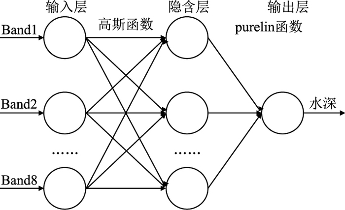
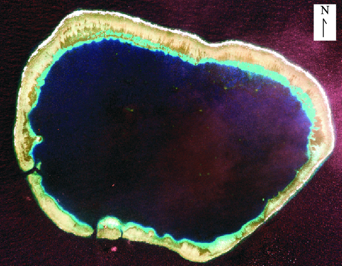
摘要: 遥感水深反演是水深测量的一种重要技术和手段.以美济礁水深反演为例,选择WorldView-02高分影像为数据源,在辐射定标和大气校正的基础上,构建BP(Back Propagation)和RBF(Radial Basis Function)人工神经网络水深反演模型,以遥感影像8个波段为输入层,通过tansig、logsig、高斯函数和purelin函数变换实现从输入层到隐含层、隐含层到输出层的转换,以便反演水深.最后对反演水深与实测水深采用回归分析,求解决定系数(coefficient of determination,R2)、平均决定误差(Mean Absolute Error,MAE)、均方根误差(Root Mean Square Error,RMSE)等进行比较,评价2种模型的精度.结果表明,RBF神经网络模型结构更简单,对样本要求更低,反演精度达到0.995,更适合遥感水深反演.
-
关键词:
- 遥感 /
- WorldView-02 /
- 水深反演 /
- BP神经网络 /
- RBF神经网络
Abstract: The inversion of water depth from remote sensing imagery is an important technology of depth measurement. In this paper, on the basis of radiometric calibration and atmospheric correction, BP(back propagation)and RBF(radial basis function) neural networks were built to retrieve water depth from WorldView-02 high-resolution satellite imagery in Mischief reef. Band 1 to band 8 of satellite imagery were used as the input data of the neural networks. Then, they were converted from input layer to hidden layer and from the hidden layer to output layer with tansig, logsig, Gaussian and purelin functions. Finally, the accuracy of the two models was evaluated by R2 (coefficient of determination), MAE(mean absolute error), RMSE(root mean square error) and the regression analysis between retrieved water depth and ground measured water depth. The results show that RBF neural network has simpler model structure, and lower requirement of samples. Besides, its retrieval accuracy reaches 0.995. Therefore, RBF neural network is more suitable for the inversion of water depth.-
Key words:
- remote sensing /
- WorldView-02 /
- water depth inversion /
- BP neural network /
- RBF neural network
-
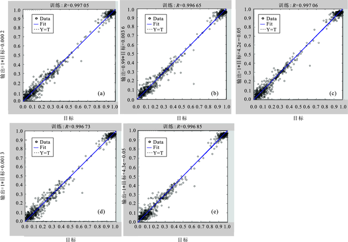
图 5 BP网络训练回归图
a.16, tansig, logsig;b.17, tansig, purelin;c.17, tansig, logsig;d, 17, logsig, logsig;e.18, tansig, logsig
Fig. 5. BP training network regression figure
表 1 辐射定标参数
Table 1. Radiometric calibration parameters
Band absCalFactorBand ΔλBand Coastal 9.295 654×10-3 4.730 000×10-2 Blue 1.783 568×10-2 5.430 000×10-2 Green 1.364 197×10-2 6.300 000×10-2 Yellow 6.810 718×10-3 3.740 000×10-2 Red 1.851 735×10-2 5.740 000×10-2 Red Edge 6.063 145×10-3 3.930 000×10-2 NIR-1 2.050 828×10-2 9.890 000×10-2 VNIR-2 9.042 234×10-3 9.960 000×10-2  下载: 导出CSV
表 2 水深值与波段反射率值的相关系数
Table 2. The correlation coefficient between water depth and band reflectance
波段 Coastal Blue Green Yellow Red Red Edge NIR-1 NIR-2 相关系数 -0.375 -0.365 -0.439 -0.470 -0.474 -0.467 -0.471 -0.469
下载: 导出CSV
表 3 BP网络训练参数
Table 3. BP training parameters
隐含层个数 隐含层函数 输出层函数 R 16 tansig logsig 0.997 05 17 tansig purelin 0.996 65 17 tansig logsig 0.997 06 17 logsig logsig 0.996 73 18 tansig logsig 0.996 85
下载: 导出CSV
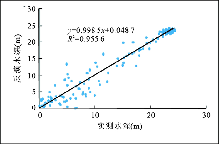
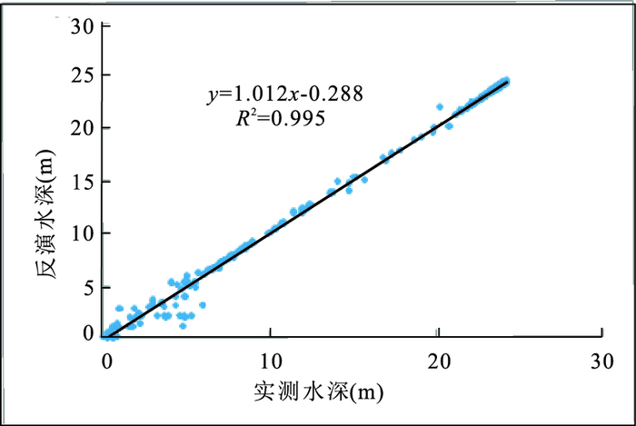
表 4 BP与RBF网络模型
Table 4. BP and RBF neural network model
网络模型 R2 MAE(m) RMSE(m) t(s) BP 0.955 6 1.149 3 1.832 1 21 RBF 0.995 0 0.406 7 0.892 2 9
下载: 导出CSV
-
Ceyhun, Ö., Yalcin, A., 2010.Remote Sensing of Water Depths in Shallow Waters via Artificial Neural Networks.Estuarine Coastal and Shelf Science, 89(1):89-96. doi: 10.1016/j.ecss.2010.05.015 Anctil, F., Coulibaly, P., 2004.Wavelet Analysis of the Interannual Variability in Southern Québec Streamflow.Journal of Climate, 17(1):163-173.doi:10.1175/1520-0442(2004)017<0163:WAOTIV>2.0.CO;2 Dang, F.X., Ding, Q., 2003.The Use of Multi-Band Satellite Data to Study Shallow Water Depth Inversion.Marine Science Bulletin, 22(3):55-60(in Chinese). Deng, Z.D., Ye, X., Guan, H.J., et al., 2013.Remote Sensing of Water Depth Based on RBF Neural Network.Journal of PLA University of Science and Technology (Natural Science Edition), 14(1):101-106(in Chinese with English abstract). http://en.cnki.com.cn/Article_en/CJFDTOTAL-JFJL201301020.htm Feng, H.J., Zhou, A.G., Yu, J.J., et al., 2016.A Comparative Study on Plum-Rain Triggered Landslide Susceptibility Assessment Models in West Zhejiang Province.Earth Science, 41(3):403-415(in Chinese with English abstract). doi: 10.1186/s40677-017-0078-9 Gao, G.D., Zhang, W.X, Mu, G.Y., 2011.A Comparative Study on RBF Network and BP Network in the Model of Salinity.Marine Science Bulletin, 30(1):12-15(in Chinese with English abstract). http://en.cnki.com.cn/Article_en/CJFDTOTAL-HUTB201101003.htm Gao, W., Liu, X.G., Peng, P., Chen, Q.H., 2010.An Improved Method of High-Resolution Remote Sense Image Segmentation.Earth Science, 35(3):421-425 (in Chinese with English abstract). http://en.cnki.com.cn/Article_en/CJFDTotal-DQKX201003020.htm Han, X.Q., Su, Y., Li, J., et al., 2012.Atmospheric Correction and Verification of the SPOT Remote Sensing Image in Coastal Zones.Geographical Research, 31(11):2007-2016(in Chinese with English abstract). http://en.cnki.com.cn/Article_en/CJFDTOTAL-DLYJ201211010.htm Huang, W.Q., Wu, D., Yang, Y., et al., 2003.Multi-Spectral Remote Sensing Water Depth Retrieval Technique in Shallow Sea.Ocean Technology, 32(2):43-46(in Chinese with English abstract). Liu, M.T., Zhang, C.C., Tian, Z.Z., et al., 2016.RBF Neural Networks Based-Study on Data Fusion for Measurement of Sediment Concentration of Yellow River.Water Resources and Hydropower Engineering, 46(1):126-130(in Chinese with English abstract). López-Serrano, P.M., Corral-Rivas, J.J., et al., 2016.Evaluation of Radiometric and Atmospheric Correction Algorithms for Aboveground Forest Biomass Estimation Using Landsat 5 TM Data.Remote Sensing, 8(5):369.doi: 10.3390/rs8050369 Lyzenga, D.R., 1978.Passive Remote Sensing Techniques for Mapping Water Depth and Botton Features.Applied Optics, 17(3):379-383.doi: 10.1364/AO.17.000379 Ma, H.Z., Liu, S.M., 2016.The Potential Evaluation of Multisource Remote Sensing Data for Extracting Soil Moisture Based on the Method of BP Neural Network.Canadian Journal of Remote Sensing, 42(2):117-124. doi: 10.1080/07038992.2016.1160773 Poupardin, A., Idier, D., De Michele, M., et al., 2015.Water Depth Inversion from a Single SPOT-5 Dataset.IEEE Transactions on Geoscience and Remote Sensing, 54(4):2329-2342.doi: 10.1109/TGRS.2015.2499379 Su, H.B., Liu, H.X., Wu, Q.S., 2015.Prediction of Water Depth From Multispectral Satellite Imagery-The Regression Kriging Alternative.IEEE Geoscience and Remote Sensing Letters, 12(12):2511-2515.doi: 10.1109/LGRS.2015.2489678 Wang, J.J., Tian, Q.J., 2007.Study on Shallow Coastal Water Depth Derived Method Based on Hyperspectral Remote Sensing.Scientia Geographica Sinica, 27(6):843-848(in Chinese with English abstract). http://en.cnki.com.cn/Article_en/CJFDTOTAL-DLKX200706019.htm Wang, Y.J., Zhang, P.Q., Dong, W.J., et al., 2007.Study on Remote Sensing of Water Depths Based on BP Artifical Neural Network.Marine Science Bulletin, 9(1):26-35. Yu, R.H., Xu, Y.P., Liu, T.X., et al., 2009.Reversing Water Depth in Shallow Lake of Arid Area Using Multi-Spectral Remote Sensing Information.Advances in Water Science, 20(1):111-117(in Chinese with English abstract). http://en.cnki.com.cn/Article_en/CJFDTOTAL-SKXJ200901019.htm Yu, Y.F., Yang, J.Z., Chen, S.B., et al., 2015.Lithologic Classification from Remote Sensing Images Based on Spectral Index.Earth Science, 40(8):1415-1419(in Chinese with English abstract). https://www.researchgate.net/publication/285601688_Lithologic... Zhou, P., Li, N., Huo, H.Y., 2015.The Quality Assessment of Hymap Simulation Spaceborne Hyperspectral Data.Earth Science, 40(8):1310-1318(in Chinese with English abstract). http://d.wanfangdata.com.cn/Periodical_dqkx201508004.aspx Zhu, Y., Zhao, Q., Zhou, X, D., 2013.Remote Sensing Water Depth Inversion Based on Chaotic Immune Optimization RBF Network.Computer Engineering, 39(5):187-191(in Chinese with English abstract). http://www.ecice06.com/EN/abstract/abstract24779.shtml 党福星, 丁谦, 2003.利用多波段卫星数据进行浅海水深反演方法研究.海洋通报, 22(3):55-60. http://www.cqvip.com/QK/92854X/200303/7858666.html 邓正栋, 叶欣, 关洪军, 等, 2013.基于RBF神经网络的水深遥感研究.解放军理工大学学报:自然科学版, 14(1):101-106. http://d.wanfangdata.com.cn/Periodical/jfjlgdxxb201301019 冯杭建, 周爱国, 俞建君, 等, 2016.浙西梅雨滑坡易发性评价模型对比.地球科学, 41(3):403-415. http://www.earth-science.net/WebPage/Article.aspx?id=3259 高国栋, 张文孝, 慕光宇, 2011.RBF网络和BP网络在海水盐度建模中的比较研究.海洋通报, 30(1):12-15. http://www.cqvip.com/QK/92854X/201101/37179382.html 高伟, 刘修国, 彭攀, 等, 2010.一种改进的高分辨率遥感影像分割方法.地球科学, 35(3):421-425. http://www.earth-science.net/WebPage/Article.aspx?id=1978 韩晓庆, 苏艺, 李静, 等, 2012.海岸带地区SPOT卫星影像大气校正方法比较及精度验证.地理研究, 31(11):2007-2016. http://www.oalib.com/paper/4252438 黄文骞, 吴迪, 杨杨, 等, 2013.浅海多光谱遥感水深反演技术.海洋技术, 32(2):43-46. http://www.cnki.com.cn/Article/CJFDTotal-HYJS201302011.htm 刘明堂, 张成才, 田壮壮, 等, 2015.基于RBF神经网络的黄河含沙量测量数据融合研究.水利水电技术, 46(1):126-130. doi: 10.3969/j.issn.1000-0860.2015.01.029 王晶晶, 田庆久, 2007.海岸带浅海水深高光谱遥感反演方法研究.地理科学, 27(6):843-848. http://www.oalib.com/paper/4168021 于瑞宏, 许有鹏, 刘廷玺, 等, 2009.应用多光谱遥感信息反演干旱区浅水湖泊水深.水科学进展, 20(1):111-117. http://www.wenkuxiazai.com/doc/a1fc38186529647d2628528f.html 于亚凤, 杨金中, 陈圣波, 等, 2015.基于光谱指数的遥感影像岩性分类.地球科学, 40(8):1415-1419. http://www.earth-science.net/WebPage/Article.aspx?id=3144 周萍, 李娜, 霍红元, 2015.基于Hymap模拟的星载高光谱数据质量评价.地球科学, 40(8):1310-1318. http://www.earth-science.net/WebPage/Article.aspx?id=3147 朱玉, 赵卿, 周兴东, 2013.基于混沌免疫优化RBF网络的遥感水深反演.计算机工程, 39(5):187-191. http://www.cqvip.com/QK/95200X/201305/45778853.html -


 点击查看大图
计量
- 文章访问数: 6647
- HTML全文浏览量: 2326
- PDF下载量: 71
- 被引次数: 0
