


Slope Stability State Monitoring and Updating of the Outang Landslide, Three Gorges Area with Time Series InSAR Analysis
-
摘要: 坡体表面形变是表征坡体稳定性的重要信息,因此,非常有必要对滑坡多发区域进行时序常规变形监测.近年来,星载合成孔径雷达数据由于其覆盖范围大、形变监测精度高的特点,被越来越多的用于山区滑坡识别与探测.首先介绍了联合分布式目标与点目标的时序InSAR方法,并将该方法应用于分析覆盖三峡藕塘滑坡的2007年至2011年的19景ALOS PALSAR数据和2015年至2018年的47景Sentinel-1数据,提取了数据覆盖时间段内的藕塘地区的变形速率.发现相比于2007年至2011年,2015年至2018年新增三处不稳定斜坡.进一步对滑坡的时序变形分析表明,降雨和水位变化是坡体稳定性最大的两个影响因素.实验证明时序InSAR方法可以作为常规形变手段来识别与监测三峡库区等地区潜在的滑坡,为防灾减灾提供支持与依据.Abstract: Slope displacement is the most direct embodiment of slope stability. Thus, it is of great significance to monitor the known landslides and detect the unknown landslides by routine time series displacements of landslide prone areas. Synthetic Aperture Radar (SAR) images with its wide coverage and capability of high presicion displacement monitoring play more and more important roles in landslide identification and detection. In this study, time series InSAR analysis method combining distributed scatterers and point-like targets is introduced. Then, we investigate the stability of the Outang landslide and surrounding slopes with 19 ALOS PALSAR images from 2007 to 2011 and 47 Sentinel-1 images from 2015 to 2018. Three new active slopes were identified with the Sentinel-1 datasets compared with the results from ALOS PALSAR datasets. Time series displacement analysis indicate the rainfall and water level fluctuation seriously affect the stability of slopes in the Three Gorges area. As a result, time series InSAR analysis can be carried out routinely to monitor and detect potential landslides.
-
Key words:
- Outang landslide /
- displacement monitoring /
- time series InSAR analysis /
- rainfall /
- water level /
- engineering geology
-
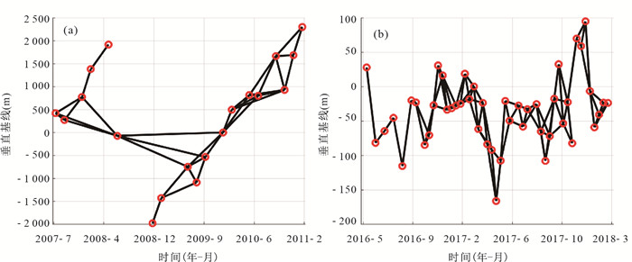
图 2 (a) ALOS PALSAR数据干涉图组合;(b) Sentinel-1数据集干涉对组合
圆圈表示影像数据,直线表示干涉图组合
Fig. 2. Interferograms used for time series InSAR analysis ALOS PALSAR (a) and Sentinel-1 (b)
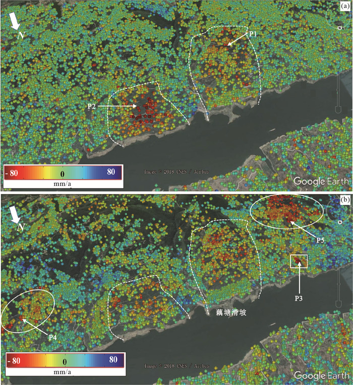
图 3 利用ALOS PALSAR数据集(a)和Sentinel-1数据集(b)获取的平均速率
虚线表示两个数据集共同探测到的滑坡范围,实线表示Sentinel-1数据探测到的滑坡.其中实线方框中为图 5所示位置
Fig. 3. Mean displacement velocity map obtained from ALOS PALSAR datasets (a) and Sentinel-1 dataset (b)

图 5 新发现滑坡示例
a.2010年3月19日Google Earth光学影像;b.2018年4月3日Google Earth光学影像;c.Sentinel-1获取平均形变速率;d.P3点时序形变与降雨和水位
Fig. 5. An example of newly detected landslide

图 4 ALOS PALSAR数据集和Sentinel-1数据集获取的(a)、(c) P1和(b)、(d) P2点形变序列与相应的水位和降雨
Fig. 4. Time series displacements of (a), (c) P1 and (b), (d) P2 from ALOS PALSAR dataset and Sentinel-1 dataset and corre sponding rainfall and water level
-
Berardino, P., Fornaro, G., Lanari, R., et al., 2002.A New Algorithm for Surface Deformation Monitoring Based on Small Baseline Differential SAR Interferograms.IEEE Transactions on Geoscience and Remote Sensing, 40(11): 2375-2383. https://doi.org/10.1109/tgrs.2002.803792 Chen, Q., Cheng, H.Q., Yang, Y.H., et al., 2014.Quantification of Mass Wasting Volume Associated with the Giant Landslide Daguangbao Induced by the 2008 Wenchuan Earthquake from Persistent Scatterer InSAR.Remote Sensing of Environment, 152: 125-135. https://doi.org/10.1016/j.rse.2014.06.002 Dai, Z.W., Yin, Y.P., Wei, Y.J., et al., 2016.Deformation and Failure Mechanism of Outang Landslide in Three Gorges Reservoir Area.Journal of Engineering Geology, 24(1): 44-55 (in Chinese with English abstract). http://www.wanfangdata.com.cn/details/detail.do?_type=perio&id=gcdzxb201601007 Deledalle, C.A., Denis, L., Tupin, F., 2011.NL-InSAR: Nonlocal Interferogram Estimation.IEEE Transactions on Geoscience and Remote Sensing, 49(4): 1441-1452. https://doi.org/10.1109/tgrs.2010.2076376 Ding, J.X., Yang, Z.F., Shang, Y.J., et al., 2006.New Method of Predicting Rainfall-Induced Lanslides.Science in China (Series D), 36(6): 579-586 (in Chinese). Dong, J., Zhang, L., Li, M.H., et al., 2018a.Measuring Precursory Movements of the Recent Xinmo Landslide in Mao County, China with Sentinel-1 and ALOS-2 PALSAR-2 Datasets.Landslides, 15(1): 135-144. https://doi.org/10.1007/s10346-017-0914-8 Dong, J., Zhang, L., Tang, M.G., et al., 2018b.Mapping Landslide Surface Displacements with Time Series SAR Interferometry by Combining Persistent and Distributed Scatterers: A Case Study of Jiaju Landslide in Danba, China.Remote Sensing of Environment, 205: 180-198. https://doi.org/10.1016/j.rse.2017.11.022 Ferretti, A., Fumagalli, A., Novali, F., et al., 2011.A New Algorithm for Processing Interferometric Data-Stacks: SqueeSAR.IEEE Transactions on Geoscience and Remote Sensing, 49(9): 3460-3470. https://doi.org/10.1109/tgrs.2011.2124465 Ferretti, A., Prati, C., Rocca, F., 2000.Nonlinear Subsidence Rate Estimation Using Permanent Scatterers in Differential SAR Interferometry.IEEE Transactions on Geoscience and Remote Sensing, 38(5): 2202-2212. https://doi.org/10.1109/36.868878 Ferretti, A., Prati, C., Rocca, F., 2001.Permanent Scatterers in SAR Interferometry.IEEE Transactions on Geoscience and Remote Sensing, 39(1): 8-20. https://doi.org/10.1109/36.898661 Hooper, A., Segall, P., Zebker, H., 2007.Persistent Scatterer Interferometric Synthetic Aperture Radar for Crustal Deformation Analysis, with Application to Volcán Alcedo, Galápagos.Journal of Geophysical Research, 112(B7 B07407. https://doi.org/10.1029/2006jb004763 Hooper, A., Zebker, H.A., 2007.Phase Unwrapping in Three Dimensions with Application to InSAR Time Series.Journal of the Optical Society of America A, 24(9): 2737-2747. https://doi.org/10.1364/josaa.24.002737 Huang, F.M., Yin, K.L., Yang, B.B., et al., 2018.Step-Like Displacement Prediction of Landslide Based on Time Series Decomposition and Multivariate Chaotic Model.Earth Science, 43(3): 887-898 (in Chinese with English abstract). http://d.old.wanfangdata.com.cn/Periodical/dqkx201803017 Huang, R.Q., 2009.Some Catastrophic Landslides since the Twentieth Century in the Southwest of China.Landslides, 6(1): 69-81. https://doi.org/10.1007/s10346-009-0142-y Jiang, M., Ding, X.L., Hanssen, R.F., et al., 2015.Fast Statistically Homogeneous Pixel Selection for Covariance Matrix Estimation for Multitemporal InSAR.IEEE Transactions on Geoscience and Remote Sensing, 53(3): 1213-1224. https://doi.org/10.1109/tgrs.2014.2336237 Jiang, M., Ding, X.L., He, X.F., et al., 2016.FaSHPS-InSAR Technique for Distributed Scatterers: A Case Study over the Lost Hills Oil Field, California.Chinese Journal of Geophysics, 59(10):3592-3603 (in Chinese with English abstract). Liao, M.S., Jiang, H.J., Wang, Y., et al., 2013.Improved Topographic Mapping through High-Resolution SAR Interferometry with Atmospheric Effect Removal.ISPRS Journal of Photogrammetry and Remote Sensing, 80: 72-79. https://doi.org/10.1016/j.isprsjprs.2013.03.008 Liu, P., Li, Z.H., Hoey, T., et al., 2013.Using Advanced InSAR Time Series Techniques to Monitor Landslide Movements in Badong of the Three Gorges Region, China.International Journal of Applied Earth Observation and Geoinformation, 21: 253-264. https://doi.org/10.1016/j.jag.2011.10.010 Qu, T.T., Lu, P., Liu, C., et al., 2016.Hybrid-SAR Technique: Joint Analysis Using Phase-Based and Amplitude-Based Methods for the Xishancun Giant Landslide Monitoring.Remote Sensing, 8(10): 874. https://doi.org/10.3390/rs8100874 Shi, X.G., Zhang, L., Balz, T., et al., 2015.Landslide Deformation Monitoring Using Point-Like Target Offset Tracking with Multi-Mode High-Resolution TerraSAR-X Data.ISPRS Journal of Photogrammetry and Remote Sensing, 105: 128-140. https://doi.org/10.1016/j.isprsjprs.2015.03.017 Shi, X.G., Liao, M.S., Li, M.H., et al., 2016.Wide-Area Landslide Deformation Mapping with Multi-Path ALOS PALSAR Data Stacks: A Case Study of Three Gorges Area, China.Remote Sensing, 8(2): 136. https://doi.org/10.3390/rs8020136 Shi, X.G., Zhang, L., Zhou, C., et al., 2018.Retrieval of Time Series Three-Dimensional Landslide Surface Displacements from Multi-Angular SAR Observations.Landslides, 15(5): 1015-1027. https://doi.org/10.1007/s10346-018-0975-3 Sun, Q., Zhang, L., Ding, X.L., et al., 2015.Slope Deformation Prior to Zhouqu, China Landslide from InSAR Time Series Analysis.Remote Sensing of Environment, 156: 45-57. https://doi.org/10.1016/j.rse.2014.09.029 Tang, P.P., Chen, F.L., Guo, H.D., et al., 2015.Large-Area Landslides Monitoring Using Advanced Multi-Temporal InSAR Technique over the Giant Panda Habitat, Sichuan, China.Remote Sensing, 7(7): 8925-8949. https://doi.org/10.3390/rs70708925 Wang, F., Yin, K.L., Gui, L., et al., 2018.Risk Analysis on Individual Reservoir Bank Landslide and Its Generated Wave.Earth Science, 43(3): 899-909 (in Chinese with English abstract). http://d.old.wanfangdata.com.cn/Periodical/dqkx201803018 Wang, F.W., Zhang, Y.M., Huo, Z.T., et al., 2008a.Mechanism for the Rapid Motion of the Qianjiangping Landslide during Reactivation by the First Impoundment of the Three Gorges Dam Reservoir, China.Landslides, 5(4): 379-386. https://doi.org/10.1007/s10346-008-0130-7 Wang, F.W., Zhang, Y.M., Huo, Z.T., et al., 2008b.Movement of the Shuping Landslide in the First Four Years after the Initial Impoundment of the Three Gorges Dam Reservoir, China.Landslides, 5(3): 321-329. https://doi.org/10.1007/s10346-008-0128-1 Wasowski, J., Bovenga, F., 2014.Investigating Landslides and Unstable Slopes with Satellite Multi Temporal Interferometry: Current Issues and Future Perspectives.Engineering Geology, 174: 103-138. https://doi.org/10.1016/j.enggeo.2014.03.003 Xia, Y., Kaufmann, H., Guo, X.F., et al., 2002.Differential SAR Interferometry Using Corner Reflectors.IEEE International Geoscience and Remote Sensing Symposium, 24-28 June 2002, Toronto, Ontario, Canada, 1243-1246.https://doi.org/10.1109/IGARSS.2002.1025902 Ye, X., Kaufmann, H., Guo, X.F., 2004.Landslide Monitoring in the Three Gorges Area Using D-InSAR and Corner Reflectors.Photogrammetric Engineering and Remote Sensing, 70(10): 1167-1172. https://doi.org/10.14358/pers.70.10.1167 Zhao, C.Y., Zhang, Q., He, Y., et al., 2016.Small-Scale Loess Landslide Monitoring with Small Baseline Subsets Interferometric Synthetic Aperture Radar Technique: Case Study of Xingyuan Landslide, Shaanxi, China.Journal of Applied Remote Sensing, 10(2): 026030. https://doi.org/10.1117/1.jrs.10.026030 Zhu, W., Zhang, Q., Ding, X.L., et al., 2014.Landslide Monitoring by Combining of CR-InSAR and GPS Techniques.Advances in Space Research, 53(3): 430-439. https://doi.org/10.1016/j.asr.2013.12.003 代贞伟, 殷跃平, 魏云杰, 等, 2016.三峡库区藕塘滑坡变形失稳机制研究.工程地质学报, 24(1):44-55. http://d.old.wanfangdata.com.cn/Periodical/gcdzxb201601007 丁继新, 杨志法, 尚彦军, 等, 2006.降雨型滑坡时空预报新方法.中国科学(D辑), 36(6):579-586. http://d.old.wanfangdata.com.cn/Periodical/zgkx-cd200606009 黄发明, 殷坤龙, 杨背背, 等, 2018.基于时间序列分解和多变量混沌模型的滑坡阶跃式位移预测.地球科学, 43(3):887-898. doi: 10.3799/dqkx.2018.909 蒋弥, 丁晓利, 何秀凤, 等, 2016.基于快速分布式目标探测的时序雷达干涉测量方法:以Lost Hills油藏区为例.地球物理学报, 59(10):3592-3603. doi: 10.6038/cjg20161007 王芳, 殷坤龙, 桂蕾, 等, 2018.单体库岸滑坡及其次生涌浪灾害风险分析.地球科学, 43(3):899-909. doi: 10.3799/dqkx.2018.910 -

 下载:
下载:

 点击查看大图
计量
- 文章访问数: 5189
- HTML全文浏览量: 1786
- PDF下载量: 78
- 被引次数: 0
