


Land Cover Change on Beach of Dongting Lake's Beach
-
摘要: 为了解20世纪70年代以来洞庭湖区湖泊洲滩地表覆盖变化,基于1978年以来的多源中分辨率遥感影像,对洲滩地表覆盖情况进行了监测,利用决策树分类方法解译,结合地理国情普查数据验证了解译精度.结果表明:近40年来,杨树和芦苇地是1978年以来变化最大的地表覆盖,二者呈此消彼长的增减状态,2007—2015年分布面积基本相当,2015年至今杨树面积大幅度减少,芦苇面积维持稳中有增的趋势.2002年以前,洞庭湖洲滩总体呈扩张趋势,2002年之后,洲滩面积趋于稳定.目前,芦苇和湖草占洞庭湖洲滩总面积的2/3.洞庭湖自然保护区内欧美黑杨主要分布于南洞庭湖自然保护区,芦苇主要分布于东洞庭湖和南洞庭湖自然保护区.洞庭湖区湖泊洲滩的人工利用程度在2015年后大幅减小,但仍有48.57%,亟待进一步控制.Abstract: In order to understand the land cover change of beach in the Dongting Lake since the 1970s, it has been systematically monitored based on various remote sensing images since 1978 in this study. Results show that poplar and reed land have experienced the largest changes of land cover in the past 40 years,showing a complementary relationship with one increased with decrease of the other. After 2007, the distribution area of poplar and reed land has been basically same. Till 2015, the distribution area of poplar land has been substantially reduced,and the distribution area of the reed land has been steadily increased. Before 2002, the beach area of Dongting Lake has been increased,after that,the area tends to be stable. Reed land and lake grass are two most covered categories in the Dongting Lake,which is 2/3 of the total beach area. In Dongting Lake Nature Reserve area,populus nigra is widely distributed in the Nature Protection Zone of South Dongting Lake,reed is widely distributed in the Nature Protection Zone of East and South Dongting Lake. Since 2015, the artificial usage of the beach in the Dongting Lake is decresed to 48.57%,but further control measures are urgently needed.
-
Key words:
- beach /
- land cover change /
- remote sensing technology /
- Dongting Lake /
- hydrogeology
-
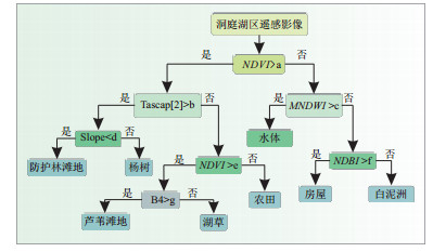
图 3 洞庭湖区湖泊洲滩地表覆盖类型决策树分类模型
Fig. 3. Decesion tree classification model to classify surface coverage in Dongting Lake
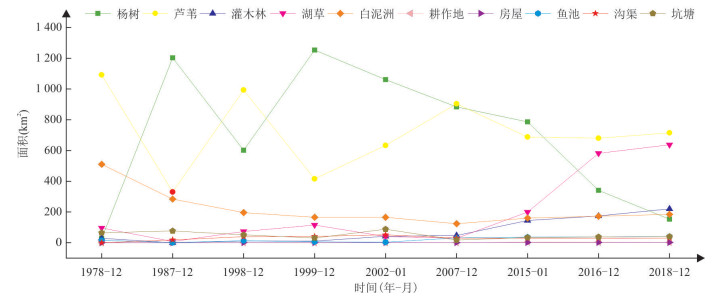
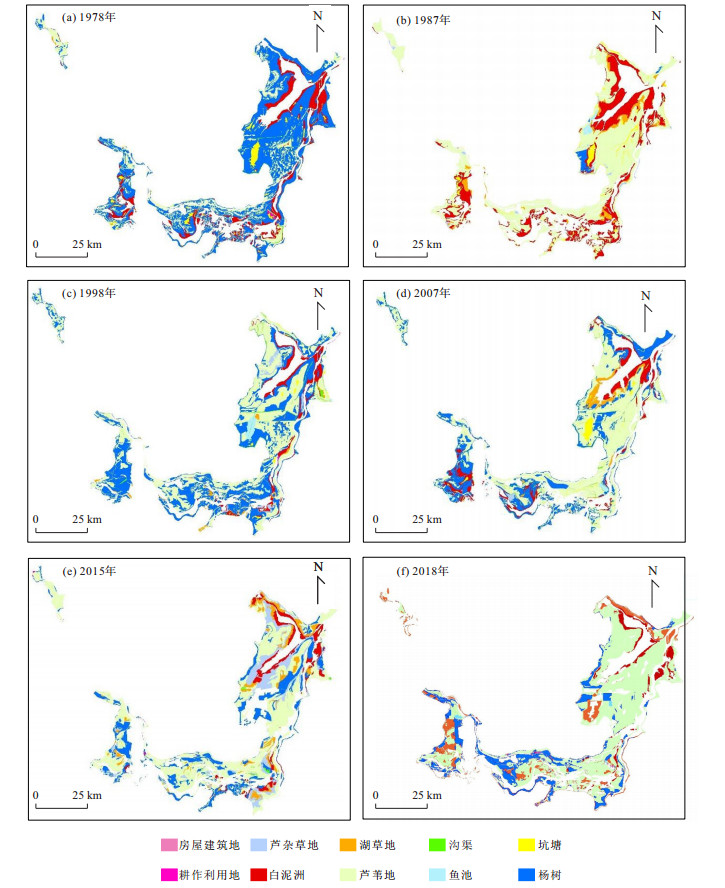
图 5 1978—2018年洞庭湖洲滩地表覆盖各类型面积变化
Fig. 5. The variation of land covers in Dongting Lake from 1978 to 2018
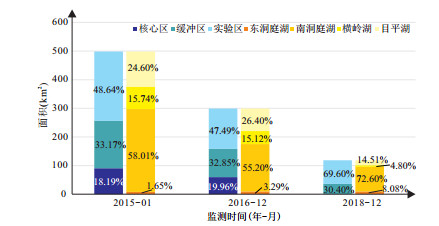
图 6 2015—2018年自然保护区(东洞庭湖、南洞庭湖、横岭湖、目平湖和核心区、缓冲区、实验区)欧美黑杨面积变化
Fig. 6. The land cover of populus nigra in Dongting Lake Natural Reserves (4 lakes and 3 areas) during 2015 to 2018
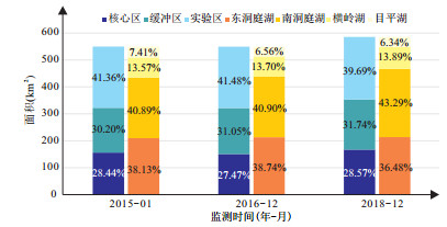
图 7 2015—2018年自然保护区(东洞庭湖、南洞庭湖、横岭湖、目平湖和核心区、缓冲区、实验区)芦苇面积变化
Fig. 7. The land covers of reed in Dongting Lake Natural Reserves (4 lakes and 3 areas) during 2015 to 2018

图 8 洞庭湖区湖泊洲滩自然和人工利用面积变化
Fig. 8. The variation of natural and artificial area about beach in Dongting Lake
表 1 遥感数据源
Table 1. Remote sensing data source
序号 数据源 获取时间(年-月-日) 空间分辨率(m) 城陵矶水位(m) 波段组合(R/G/B) 1 MSS 1978-12-17 79 20.45 3(R)/4(G)/1(B) 2 TM 1987-12-06 30 19.93 5(R)/4(G)/3(B) 3 TM 1998-12-20 30 20.66 5(R)/4(G)/3(B) 4 ETM 1999-12-15 30 21.78 5(R)/4(G)/3(B) 5 ETM 2002-01-05 30 20.56 5(R)/4(G)/3(B) 6 CBERS-1 2007-12-23 19.5 20.42 3(R)/4(G)/2(B) 7 ETM 2015-01-14 30 20.41 7(R)/5(G)/4(B) 8 ETM 2016-12-20 30 20.66 7(R)/5(G)/4(B) 9 HJ-1 2018-12-30 30 20.96 3(R)/4(G)/2(B)  下载: 导出CSV
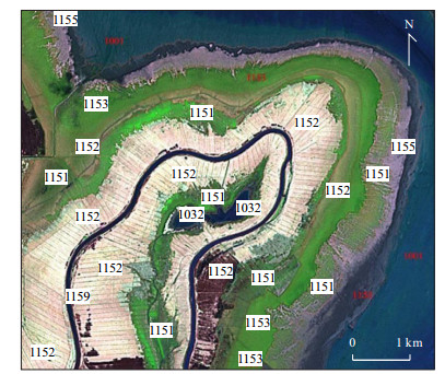
表 2 各类地表覆盖类型遥感影像标志
Table 2. The signs of land cover type
代码 类型 遥感影像标志 1151 杨(柳)树林地 深绿色,块状,影纹较粗呈斑状、颗粒状,人工栽种的杨树行列较规则,边界轮廓明显,一般紧邻堤坝而远离湖泊水域,大部位于常水位以上. 1152 芦苇地 呈绿色(生长期)、白色(收割后)、黑色(火烧),块状或条带状的规则形态,多网格状道路、沟渠等人工活动痕迹,多生于低湿地或浅水中. 1153 芦杂草地 呈浅绿色或草黄色(冬季),块状或条带状分布,影纹较杨树细,细斑或点状,人工痕迹较少. 1154 湖草地 呈亮绿色或草黄色(冬季),蠕虫状或破布状的不规则形态,影纹较光滑细密,一般人工干预痕迹较少. 1155 白泥洲 呈暗红色、白色、浅红色等,块状或条带状分布,影纹光滑,一般靠近湖泊或河道的水面分布. 1156 耕作利用地 呈绿色、白色、褐色等杂色,块状或条带状规则形态,影纹粗糙,有道路、沟渠等分布. 1157 房屋建筑地 呈暗红色、白色,一般分布于堤坝边沿,呈带状或块状分布,形状规则,斑状或斑块状影纹. 1158 鱼池 呈蓝色或黑色,块状或带状分布,一般由堤坝或土坎分割呈规则长方形块状. 1159 沟渠 分布于洲滩中的条带状水体. 1032 坑塘 分布于洲滩上的斑状、块状的形状不规则的水体.
下载: 导出CSV
表 3 洞庭湖区湖泊洲滩地表覆盖面积(km2)
Table 3. The land cover of beach in Dongting Lake
监测时间 杨树 芦苇 芦杂草 湖草 白泥洲 耕作地 房屋 鱼池 沟渠 坑塘 洲滩面积 1978-12 28.26 1 092.00 29.07 96.30 510.60 15.63 64.96 1 836.53 1987-12 1 203.31 329.70 0.31 7.57 284.20 4.07 0.66 18.55 76.74 1 925.15 1998-12 602.05 993.70 11.06 73.01 196.00 1.41 0.76 13.01 39.68 51.05 1 981.77 1999-12 1 253.82 415.40 10.90 115.10 165.30 1.09 6.45 41.40 30.86 2 040.39 2002-01 1 061.66 633.20 41.80 40.11 165.70 0.88 2.04 3.33 51.31 88.12 2 088.15 2007-12 883.64 904.00 47.04 29.10 124.00 1.34 1.03 31.76 30.47 17.96 2 070.25 2015-01 885.93 788.10 54.41 99.64 160.33 4.42 1.49 26.56 29.38 34.15 2 084.44 2016-12 340.45 680.39 174.41 581.24 172.44 3.63 1.52 37.21 29.81 37.26 2 058.36 2018-12 152.92 715.06 220.21 637.66 184.85 2.99 1.65 41.36 30.46 40.17 2 027.33
下载: 导出CSV
表 4 洞庭湖自然保护区欧美黑杨与芦苇覆盖面积(km2)
Table 4. The land covers of populus nigra and reed in Dongting Lake
监测区域 欧美黑杨 芦苇 2015-01 2016-12 2018-12 2015-01 2016-12 2018-12 东洞庭湖 核心区 0.27 0.23 0 24.02 24.34 24.37 缓冲区 0.86 1.69 4.31 55.96 59.21 59.86 实验区 7.08 7.92 5.27 129.68 129.79 129.37 南洞庭湖 核心区 30.30 17.14 0 69.64 69.66 82.55 缓冲区 80.43 45.70 23.81 80.40 80.53 94.31 实验区 178.53 102.49 62.23 74.81 74.49 76.60 横岭湖 核心区 9.62 7.20 0 33.63 33.63 36.11 缓冲区 44.27 25.68 0.24 19.86 19.89 21.17 实验区 24.60 12.41 5.45 21.11 21.72 24.04 目平湖 核心区 50.53 35.20 0 29.11 23.28 24.24 缓冲区 39.84 25.33 7.67 9.82 10.90 10.50 实验区 32.32 18.53 9.53 1.81 1.85 2.41 合计 498.65 299.52 118.51 549.85 549.29 585.53
下载: 导出CSV
-
Ba, S., Liu, Z.H., Zhang, Z.J., et al., 2011.Decision Tree and Its Application in Remote Sensing Image Classification.Plateau and Mountain Meteorology Research, 31(2):31-34(in Chinese with English abstract). http://d.old.wanfangdata.com.cn/Periodical/ygjsyyy201405006 Chen, J., Chen, J., Gong, P., et al., 2011.Higher Resolution Global Land Cover Mapping.Geomatics World, 18(2):12-14(in Chinese with English abstract). http://d.old.wanfangdata.com.cn/Periodical/dlxxsj201102002 He, J., Xu, Y.P., Xu, D.B., .et al., 2018.A Review after General Secretary Xi Jingping Visiting the Yangtze River Economic Area in Hunan.Xinxiang Review, (13):12-16(in Chinese). Jia, H.C., Pan, D.H., Zhang, W.C., 2014.Study on Land Use/Cover Change Impact on Wetlands of Dongting Lake Area for nearly 30 Years.China Population, Resources and Environment, 24(Suppl.3):126-128(in Chinese with English abstract). Li, J.B., Wang, K.L., Qin, J.X., et al., 2005.The Evolution of Annual Runoff and Sediment in the Dongting Lake and Their Driving Forces.Acta Geographica Sinica, 60(3):503-510(in Chinese with English abstract). http://www.wanfangdata.com.cn/details/detail.do?_type=perio&id=dlxb200503017 Li, X.B., 1996.A Review of the International Researches on Land Use/Land Cover Change.Acta Geographica Sinica, 51(6):553-558(in Chinese with English abstract). Lin, G.J., Li, Z.J., Lei, M.J., et al., 2015.Response of Land Cover in Dongting Lake to Water Level Change of Yangtze River.Yangtze River, 46(19):114-118(in Chinese with English abstract). http://www.wanfangdata.com.cn/details/detail.do?_type=perio&id=rmcj201519027 Na, X.D., Zhang, S.Q., Kong, B., et al., 2008.The Extraction of Freshwater Marsh Wetland Information Based on Decision Tree Algorithm:A Case Study in the Northeast of the Sanjiang Plain.Remote Sensing Technology and Application, 23(4):365-372(in Chinese with English abstract). Provincial Land Commission Office in Hunan, 1985.Comprehensive Investigation Report on Utilization and Development of Dongting Lake Area.Provincial Land Commission Office in Hunan, Changsha, 18-20(in Chinese). Qin, Y.M., Gong, J., Gu, Y.S., et al., 2018.Ecological Monitoring and Environmental Significance of Testate Amoebae in Subalpine Pearlands in West Hubei Province, China.Earth Science, 43(11):4036-4045(in Chinese with English abstract). Schneider, J., Grosse, G., Wagner, D., 2009.Land Cover Classification of Tundra Environments in the Arctic Lena Delta Based on Landsat 7 ETM+ Data and Its Application for Upscaling of Methane Emissions.Remote Sensing of Environment, 113(2):380-391. https://doi.org/10.1016/j.rse.2008.10.013 Shi, J.N., Xu, Y.X., Liu, Q.H., 2010.An Analysis on the Variation of Landscape Pattern of Dongting Lake Wetland Reserve.Journal of Central South University of Forestry & Technology, 30(6):18-26(in Chinese with English abstract). http://www.wanfangdata.com.cn/details/detail.do?_type=perio&id=znlxyxb201006004 Tan, Z.Q., Xu, X.L., Li, Y.L., et al., 2017.Wetland Landscape Pattern Evolution of Large Yangtze-Connected Lakes in the Middle Reaches of Yangtze River.Resources and Environment in the Yangtze Basin, 26(10):1619-1624(in Chinese with English abstract). Xie, Y.H., Chen, X.S., 2008. Effects of Three-Gorge Project on Succession of Wetland Vegetation in Dongting Lake.Research of Agricultural Modernization, 29(6):684-687(in Chinese with English abstract). http://www.wanfangdata.com.cn/details/detail.do?_type=perio&id=nyxdhyj200806011 Yang, L., Xie, B.G., Qin, J.X., et al., 2013.Changes in Dongting Lake Wetland Landscape Pattern Related to Pre-and Post-Construction of the Three Gorges Dam.Journal of Natural Resources, 28(12):2068-2080(in Chinese with English abstract). http://www.wanfangdata.com.cn/details/detail.do?_type=perio&id=zrzyxb201312005 Yu, D.Q., Yu.S.C., He, Q.H., et al., 2016.Monitoring of Dongting Lake Atrophy in the Past 100 Years by Combining Historical Map and Remote Sensing Technology.Remote Sensing for Land & Resources, 28(3):116-122(in Chinese with English abstract). http://www.wanfangdata.com.cn/details/detail.do?_type=perio&id=gtzyyg201603019 巴桑, 刘志红, 张正健, 等, 2011.决策树在遥感影像分类中的应用.高原山地气象研究, 31(2):31-34. http://d.old.wanfangdata.com.cn/Periodical/scqx201102005 陈军, 陈晋, 宫鹏, 等, 2011.全球地表覆盖高分辨率遥感制图.地理信息世界, 18(2):12-14. http://d.old.wanfangdata.com.cn/Periodical/dlxxsj201102002 贺佳, 徐亚平, 徐典波, 等, 2018.万里长江水云阔习近平总书记在湘考察长江经济带发展回访记.新湘评论, (13):12-16. http://www.wanfangdata.com.cn/details/detail.do?_type=perio&id=0120181104623346 湖南省国土委员会办公室, 1985.湖南洞庭湖区整治开发综合考察研究报告.长沙: 湖南省国土委员会办公室, 18-20. 贾慧聪, 潘东华, 张万昌, 2014.洞庭湖区近30年土地利用/覆盖变化对湿地的影响分析.中国人口·资源与环境, 24(增刊3):126-128. 李景保, 王克林, 秦建新, 等, 2005.洞庭湖年径流泥沙的演变特征及其动因.地理学报, 60(3):503-510. http://d.old.wanfangdata.com.cn/Periodical/dlxb200503017 李秀彬, 1996.全球环境变化研究的核心领域——土地利用/土地覆被变化的国际研究动向.地理学报, 51(6):553-558. 林国俊, 李志军, 雷明军, 等, 2015.洞庭湖区土地覆被对长江水位变化的响应分析.人民长江, 46(19):114-118. http://d.old.wanfangdata.com.cn/Periodical/rmcj201519027 那晓东, 张树清, 孔博, 等, 2008.基于决策树方法的淡水沼泽湿地信息提取——以三江平原东北部为例.遥感技术与应用.遥感技术与应用, 23(4):365-372. http://www.wanfangdata.com.cn/details/detail.do?_type=perio&id=ygjsyyy200804001 秦养民, 巩静, 顾延生, 等, 2018.鄂西亚高山泥炭地壳变形虫生态监测及对水位的指示意义.地球科学, 43(11):4036-4045. doi: 10.3799/dqkx.2018.599 石军南, 徐永新, 刘清华, 2010.洞庭湖湿地保护区景观格局变化及原因分析.中南林业科技大学学报, 30(6):18-26. http://d.old.wanfangdata.com.cn/Periodical/znlxyxb201006004 谭志强, 许秀丽, 李云良, 2017.长江中游大型通江湖泊湿地景观格局演变特征.长江流域资源与环境, 26(10):1619-1624. http://d.old.wanfangdata.com.cn/Periodical/cjlyzyyhj201710015 谢永宏, 陈心胜, 2008.三峡工程对洞庭湖湿地植被演替的影响.农业现代化研究, 29(6):684-687. http://d.old.wanfangdata.com.cn/Periodical/nyxdhyj200806011 杨利, 谢炳辉, 秦建新, 等, 2013.三峡建坝前后洞庭湖区湿地景观格局变化.自然资源学报, 28(12):2068-2080. http://www.wanfangdata.com.cn/details/detail.do?_type=perio&id=zrzyxb201312005 余德清, 余姝辰, 贺秋华, 等, 2016.联合历史地图与遥感技术的洞庭湖百年萎缩监测.国土资源遥感, 28(3):116-122. http://d.old.wanfangdata.com.cn/Periodical/gtzyyg201603019 -

 点击查看大图
计量
- 文章访问数: 1663
- HTML全文浏览量: 745
- PDF下载量: 68
- 被引次数: 0
