


Monitoring Lake Level Variations in Dongting Lake Basin over 2003—2017 Using Multi-mission Satellite Altimetry Data
-
摘要: 利用ICESat-1和CryoSat-2测高数据获取了2003—2017年洞庭湖流域内湖泊的水位信息,分析了湖泊水位的时间变化过程,并结合TRMM卫星降水数据及人类用水等数据,讨论了湖泊水位变化对气候及人类活动的响应.结果表明,流域中80%的湖泊在2003—2009年呈现出水位下降趋势(-0.18~-0.09 m/a);75%的湖泊在2010—2017年呈现出水位稳定或上升趋势(0~0.39 m/a);总体来看,75%的湖泊在2003—2017年呈现出水位上升趋势(0.02~0.22 m/a).分析表明,湖泊水位变化为多种因素共同作用的结果,降水为近年来洞庭湖流域内湖泊水位变化的主要驱动因子;以三峡水库为代表的水库运行会对湖泊水位产生季节性影响;同时,人类用水的持续增长也对湖泊水位有一定的影响.多源测高卫星为长时序大范围的湖泊水位监测提供了有力的手段,这对研究湖泊水位变化及其与气候和环境的响应具有重要意义.Abstract: Due to the impacts of climate change and anthropogenic activities, water resource issues are challenging and have been received much attention worldwide. Over the last few decades, the development of satellite altimetry has enabled the monitoring of lake levels over a large spatial extent. In this work, water-level changes from lakes in Dongting Lake basin were derived from ICESat-1 and CryoSat-2 altimetry data during the period of 2003 to 2017. The temporal variation of lake water levels was analyzed to characterize the water level dynamics in different periods. The TRMM satellite precipitation data and human water consumption data were collected to identify the responses of lake water level changes to both climate change and human activities. The results indicate that 80% of the lakes in the basin exhibite a downward trend (-0.18 to -0.09 m/a) in lake water levels in 2003—2009, while 75% of the lakes show a stable or rising trend (0-0.39 m/a) in water levels in 2010—2017. In general, 75% of the lakes show a rising trend (0.02-0.22 m/a) in water levels during the period of 2003 to 2017. The analysis reveals that the change of lake water levels is the result of a combination of multiple factors. Precipitation is the main driving factor for lake water level change. In addition, the operation of reservoirs produced a seasonal variation in the water level of lakes. The continued growth of human water consumption also has a certain impact on the lake water level. Multi-mission altimetry satellite provides a powerful tool for the long-term and large-scale monitoring of lake level variations, which is of great significance to the study of lake level change and its response to climate and environment.
-
Key words:
- satellite altimetry /
- lake water level /
- Dongting Lake basin /
- ICESat-1 /
- CryoSat-2 /
- hydrogeology
-
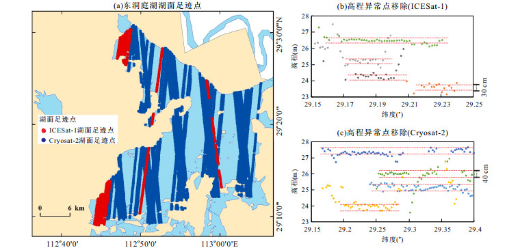
图 2 两颗卫星在东洞庭湖的湖面足迹点(a)及高程异常点移除示意图(b, c)
Fig. 2. The map of lake footprints (a) and outliers removal (b, c) of two satellites on East Dongting Lake
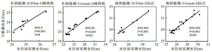
图 3 东洞庭湖及南洞庭湖的卫星测高水位与水文站实测水位的相关性
R表示相关系数,P表示显著性值,N表示点数
Fig. 3. Correlation between water level derived by satellite altimetry and the in-situ observations in East and South Dongting Lakes
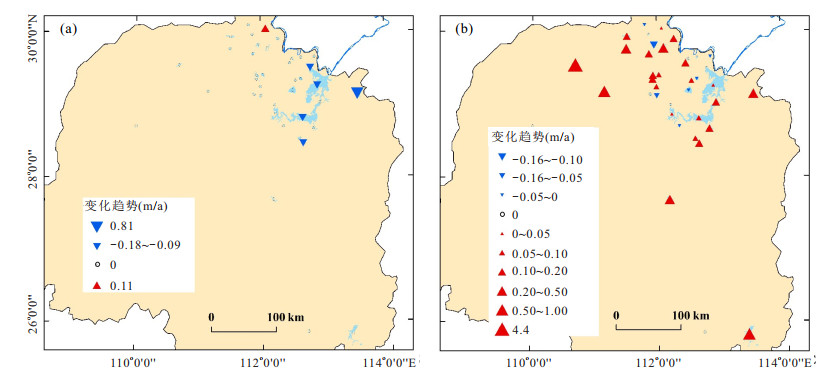
图 4 2003—2009年(a)及2010—2017年(b)洞庭湖流域湖泊水位变化图
Fig. 4. The map of lake level change in Dongting Lake basin during the period of 2003—2009 (a) and 2010—2017 (b)
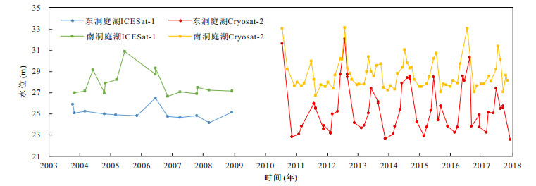
图 5 2003—2017年东洞庭湖及南洞庭湖水位时间序列图
Fig. 5. Time series water level of East Dongting Lake and South Dongting Lake from 2003 to 2017
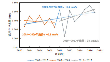
图 6 基于TRMM 3B43数据的洞庭湖流域2003—2017年降水变化
Fig. 6. The change chart of annual precipitation derived by TRMM 3B43 data in Dongting basin during 2003—2017
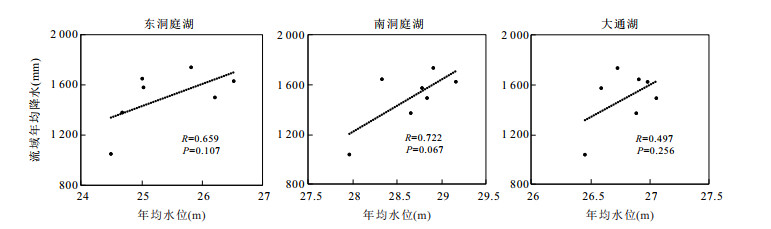
图 7 湖泊年均水位与流域年降水量相关性分析
Fig. 7. Correlation between the annual average lake levels and annual precipitation of basin
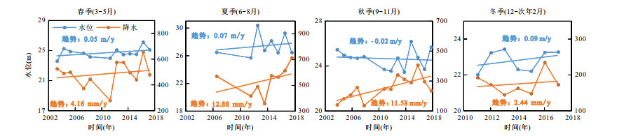
图 8 东洞庭湖季节水位变化与流域季节降水变化
Fig. 8. The seasonal change chart of precipitation and water level in East Dongting Lake
表 1 结合两种卫星测高数据的数据处理结果(2003—20017)
Table 1. Data process results by combining two satellite altimetry data (2003—2017)
湖名 水位数量 平均湖面足迹点数 起始日期
(年-月-日)起始水位
(m)结束日期
(年-月-日)结束水位
(m)变化趋势(m/a) R2 大通湖 26 17 2004-10-27 26.82 2017-10-09 26.63 -0.01 0.030 6 南千渠 14 5 2003-03-20 30.54 2017-06-19 29.8 -0.01 0.016 3 无名湖泊 19 7 2003-10-26 34.54 2017-12-06 34.85 0.02 0.041 7 采桑湖 13 8 2003-11-02 26.4 2017-9-10 26.6 0.03 0.052 3 东洞庭湖 61 27 2003-03-07 23.61 2017-12-04 22.75 0.03 0.002 9 南洞庭湖 81 15 2003-11-02 26.95 2017-11-07 28.15 0.06 0.031 6 团头湖 16 3 2003-11-02 27.81 2017-07-16 31.04 0.20 0.453 7 烂泥湖 13 6 2004-03-05 25.66 2017-04-22 27.45 0.22 0.661 4 铁山水库 16 8 2004-03-13 86.58 2017-10-07 91.63 0.36 0.351 2  下载: 导出CSV
-
Cheng, J.X., Xu, L.G., Jiang, J.H., et al., 2016.The Research of Runoff Responses to Climate Change and Human Activities in the Dongting Lake Catchment.Journal of Agro-Environment Science, 35(11):2146-2153(in Chinese with English abstract). http://www.wanfangdata.com.cn/details/detail.do?_type=perio&id=nyhjbh201611016 Göttl, F., Dettmering, D., Müller, F., et al., 2016.Lake Level Estimation Based on Cryosat-2 SAR Altimetry and Multi-Looked Waveform Classification.Remote Sensing, 8(11):885. https://doi.org/10.3390/rs8110885 Jain, M., Andersen, O.B., Dall, J., et al., 2015.Sea Surface Height Determination in the Arctic Using Cryosat-2 SAR Data from Primary Peak Empirical Retrackers.Advances in Space Research, 55(1):40-50. https://doi.org/10.1016/j.asr.2014.09.006 Jiang, L.G., Nielsen, K., Andersen, O.B., et al., 2017a.Monitoring Recent Lake Level Variations on the Tibetan Plateau Using Cryosat-2 SARIn Mode Data.Journal of Hydrology, 544:109-124. https://doi.org/10.1016/j.jhydrol.2016.11.024 Jiang, L.G., Nielsen, K., Andersen, O.B., et al., 2017b.Cryosat-2 Radar Altimetry for Monitoring Freshwater Resources of China.Remote Sensing of Environment, 200:125-139. https://doi.org/10.1016/j.rse.2017.08.015 Jiang, W.P., 2001.The Applications of Satellite Altimetry Technology in Geodesy (Dissertation).Wuhan University, Wuhan(in Chinese with English abstract). Jin, T.Y., Li, J.C., Jiang, W.P., et al., 2011.The New Generation of Global Mean Sea Surface Height Model Based on Multi-Altimetric Data.Acta Geodaetica et Cartographica Sinica, 40(6):723-729(in Chinese with English abstract). Kleinherenbrink, M., Ditmar, P.G., Lindenbergh, R.C., 2014.Retracking Cryosat Data in the SARIn Mode and Robust Lake Level Extraction.Remote Sensing of Environment, 152:38-50. https://doi.org/10.1016/j.rse.2014.05.014 Lai, X.J., Jiang, J.H., Huang, Q., 2012.Pattern of Impoundment Effects and Influencing Mechanism of Three Gorges Project on Water Regime of Lake Dongting.Journal of Lake Sciences, 24(2):178-184(in Chinese with English abstract). doi: 10.18307/2012.0202 Li, D., Christakos, G., Ding, X., et al., 2018.Adequacy of TRMM Satellite Rainfall Data in Driving the SWAT Modeling of Tiaoxi Catchment (Taihu Lake Basin, China).Journal of Hydrology, 556:1139-1152. https://doi.org/10.1016/j.jhydrol.2017.01.006 Li, H., Yu, Z.D., Cai, X.B., et al., 2017.River Terrace Extraction Based on Unmanned Aerial Vehicle Remote Sensing.Earth Science, 42(5):734-742(in Chinese with English abstract). http://www.wanfangdata.com.cn/details/detail.do?_type=perio&id=dqkx201705009 Li, J.C., Chu, Y.H., Jiang, W.P., et al., 2007.Monitoring Level Fluctuation of Lakes in Yangtze River Basin by Altimetry.Geomatics and Information Science of Wuhan University, 32(2):144-147(in Chinese English abstract). http://d.old.wanfangdata.com.cn/Periodical/zykx201212009 Li, J.G., Li, J.R., Huang, S.F., et al., 2010a.The Remote Sensing Monitoring Analysis of Chinese Dongting Lake Water Area Variations in Last 10 Years Using Terra/MODIS Data Time Series.Journal of China Institute of Water Resources and Hydropower Research, 8(3):201-207(in Chinese with English abstract). Li, J.G., Li, J.R., Huang, S.F., et al., 2010b.Characteristics of the Recent 10-Year Flood/Drought over the Dongting Lake Basin Based on TRMM Precipitation Data and Regional Integrated Z-Index.Resources Science, 32(6):1103-1110(in Chinese with English abstract). http://www.wanfangdata.com.cn/details/detail.do?_type=perio&id=zykx201006014 Li, J.G., Li, J.R., Ruan, H.X., et al., 2010c.Application of Jason-2 Altimetry Data in Monitoring of Continental Water Level Fluctuations.Journal of Natural Resources, 25(3):502-510(in Chinese with English abstract). http://www.wanfangdata.com.cn/details/detail.do?_type=perio&id=zrzyxb201003015 Li, J.L., Chen, X., Bao, A.M., 2011.Spatial-Temporal Characteristics of Lake Level Changes in Central Asia during 2003-2009.Acta Geographica Sinica, 66(9):1219-1229(in Chinese with English abstract). http://www.wanfangdata.com.cn/details/detail.do?_type=perio&id=dlxb201109007 Liu, W.Q., Qian, Z., Zhang, S.H., 2016.The Analysis of Evolution Trend and Causes of Water Level Variation in Dongting Lake.China Flood & Drought Management, 26(4):51-54(in Chinese with English abstract). http://www.wanfangdata.com.cn/details/detail.do?_type=perio&id=zgfxkh201604014 Liu, Y.B., Fu, Q.N., Song, P., et al., 2011.Satellite Retrieval of Precipitation:An Overview.Advances in Earth Science, 26(11):1162-1172(in Chinese with English abstract). http://d.old.wanfangdata.com.cn/Periodical/zghjkx201805010 Nielsen, K., Stenseng, L., Andersen, O.B., et al., 2015.Validation of Cryosat-2 SAR Mode Based Lake Levels.Remote Sensing of Environment, 171:162-170. https://doi.org/10.1016/j.rse.2015.10.023 Phan, V.H., Lindenbergh, R., Menenti, M., 2012.ICESat Derived Elevation Changes of Tibetan Lakes between 2003 and 2009.International Journal of Applied Earth Observation and Geoinformation, 17:12-22. https://doi.org/10.1016/j.jag.2011.09.015 Phillips, H.A., Hons, B.S., 1999.Applications of ERS Satellite Radar Altimetry in the Lambert Glacier-Amery Ice Shelf System, East Antarctica (Dissertation).Australia University of Tasmania, Hobart. Song, C.Q., Ye, Q.H., Sheng, Y.W., et al., 2015.Combined ICESat and Cryosat-2 Altimetry for Accessing Water Level Dynamics of Tibetan Lakes over 2003-2014.Water, 7(12):4685-470. https://doi.org/10.3390/w7094685 Villadsen, H., Deng, X., Andersen, O.B., et al., 2016.Improved Inland Water Levels from SAR Altimetry Using Novel Empirical and Physical Retrackers.Journal of Hydrology, 537:234-247. https://doi.org/10.1016/j.jhydrol.2016.03.051 Wan, R.R., Yang, G.S., Wang, X.L., et al., 2014.Progress of Research on the Relationship between the Yangtze River and Its Connected Lakes in the Middle Reaches.Journal of Lake Sciences, 26(1):1-8(in Chinese with English abstract). doi: 10.18307/2014.0101 Wan, W., Xiao, P.F., Feng, X.Z., et al., 2014, Monitoring Lake Changes of Qinghai-Tibetan Plateau over the Past 30 Years Using Satellite Remote Sensing Data.Chinese Science Bulletin, 59(8):701-714(in Chinese). doi: 10.1360/csb2014-59-8-701 Wang, J., Sheng, Y., Wada, Y., 2017.Little Impact of the Three Gorges Dam on Recent Decadal Lake Decline across China's Yangtze Plain.Water Resources Research, 53(5):3854-3877. https://doi.org/10.1002/2016wr019817 Wang, J.D., Sheng, Y.W., Tong, T.S.D., 2014.Monitoring Decadal Lake Dynamics across the Yangtze Basin Downstream of Three Gorges Dam.Remote Sensing of Environment, 152:251-269. https://doi.org/10.1016/j.rse.2014.06.004 Wang, X.W., Gong, P., Zhao, Y.Y., et al., 2013.Water-Level Changes in China's Large Lakes Determined from ICESat/GLAS Data.Remote Sensing of Environment, 132:131-144. https://doi.org/10.1016/j.rse.2013.01.005 Xiang, F.F., Wang, L.C., Yao, R., et al., 2018.The Characteristics of Climate Change and Response of Vegetation in Three Gorges Reservoir Area.Earth Science, 43(Suppl.1):42-52(in Chinese with English abstract). http://d.old.wanfangdata.com.cn/Periodical/dqkx2018z1005 Yi, B.L., Li, X.B., Mei, J.H., 2000.Studying on the Relation of the Area, the Volume and the Water of Dongting Lake and Evaluating about the Ability to Modulate and Store the Flood Water.Hunan Geology, 19(4):267-270(in Chinese with English abstract). Yuan, M., Li, Z.W., Xie, G.X., et al., 2014.Effects of the Three Gorges Project on the Water Surface Area of Lake Dongting, 2000-2010.Journal of Lake Sciences, 26(1):37-45(in Chinese with English abstract). doi: 10.18307/2014.0105 Zhang, G.Q., Xie, H.J., Kang, S.H., et al., 2011.Monitoring Lake Level Changes on the Tibetan Plateau Using ICESat Altimetry Data (2003-2009).Remote Sensing of Environment, 115(7):1733-1742. https://doi.org/10.1016/j.rse.2011.03.005 Zhang, X., Wu, Y.H., 2015.Zhari Namco Water Level Change Detection Using Multi-Satellite Altimetric Data during 1992-2012.Journal of Natural Resources, 30(7):1153-1162(in Chinese with English abstract). http://www.wanfangdata.com.cn/details/detail.do?_type=perio&id=zrzyxb201507008 Zhao, Y., Liao, J.J., Shen, G.Z., et al., 2017.Monitoring the Water Level Changes in Qinghai Lake with Satellite Altimetry Data.Journal of Remote Sensing, 21(4):633-644(in Chinese with English abstract). http://d.old.wanfangdata.com.cn/Periodical/ygxb201704014 Zhou, H., 2016.Impact of Climate Change on Water Resources in Dongting Lake Basin (Dissertation).Hunan Normal University, Changsha(in Chinese with English abstract). Zwally, H.J., Schutz, B., Abdalati, W., et al., 2002.ICESat's Laser Measurements of Polar Ice, Atmosphere, Ocean, and Land.Journal of Geodynamics, 34:405-445. https://doi.org/10.1016/s0264-3707(02)00042-x 程俊翔, 徐力刚, 姜加虎, 等, 2016.洞庭湖流域径流量对气候变化和人类活动的响应研究.农业环境科学学报, 35(11):2146-2153. doi: 10.11654/jaes.2016-0554 姜卫平, 2001.卫星测高技术在大地测量学中的应用(博士学位论文).武汉: 武汉大学. 金涛勇, 李建成, 姜卫平, 等, 2011.基于多源卫星测高数据的新一代全球平均海面高模型.测绘学报, 40(6):723-729. http://www.cnki.com.cn/Article/CJFDTotal-CHXB201106011.htm 赖锡军, 姜加虎, 黄群, 等, 2012.三峡工程蓄水对洞庭湖水情的影响格局及其作用机制.湖泊科学, 24(2):178-184. doi: 10.3969/j.issn.1003-5427.2012.02.002 李辉, 余忠迪, 蔡晓斌, 等, 2017.基于无人机遥感的河流阶地提取.地球科学, 42(5):734-742. doi: 10.3799/dqkx.2017.061 李建成, 褚永海, 姜卫平, 等, 2007.利用卫星测高资料监测长江中下游湖泊水位变化.武汉大学学报(信息科学版), 32(2):144-147. http://d.old.wanfangdata.com.cn/Periodical/whchkjdxxb200702013 李景刚, 李纪人, 黄诗峰, 等, 2010a.近10年来洞庭湖区水面面积变化遥感监测分析.中国水利水电科学研究院学报, 8(3):201-207. http://d.old.wanfangdata.com.cn/Periodical/zgslsdkxyjyxb201003008 李景刚, 李纪人, 黄诗峰, 等, 2010b.基于TRMM数据和区域综合Z指数的洞庭湖流域近10年旱涝特征分析.资源科学, 32(6):1103-1110. http://d.old.wanfangdata.com.cn/Periodical/zykx201006014 李景刚, 李纪人, 阮宏勋, 等, 2010c.Jason-2卫星测高数据在陆地水域水位变化监测中的应用.自然资源学报, 25(3):502-510. http://www.wanfangdata.com.cn/details/detail.do?_type=perio&id=zrzyxb201003015 李均力, 陈曦, 包安明, 2011.2003-2009年中亚地区湖泊水位变化的时空特征.地理学报, 66(9):1219-1229. http://d.old.wanfangdata.com.cn/Periodical/dlxb201109007 刘万千, 钱湛, 张双虎, 2015.洞庭湖水位变化趋势及原因分析.中国防汛抗旱, 26(4):51-54. doi: 10.3969/j.issn.1673-9264.2015.04.014 刘元波, 傅巧妮, 宋平, 等, 2011.卫星遥感反演降水研究综述.地球科学进展, 26(11):1162-1172. http://d.old.wanfangdata.com.cn/Periodical/dqkxjz201111006 万荣荣, 杨桂山, 王晓龙, 等, 2014.长江中游通江湖泊江湖关系研究进展.湖泊科学, 26(1):1-8. http://d.old.wanfangdata.com.cn/Periodical/hpkx201401001 万玮, 肖鹏峰, 冯学智, 等, 2014.卫星遥感监测近30年来青藏高原湖泊变化.科学通报, 59(8):701-714. http://www.wanfangdata.com.cn/details/detail.do?_type=perio&id=kxtb201408008 向菲菲, 王伦澈, 姚瑞, 等, 2018.三峡库区气候变化特征及其植被响应.地球科学, 43(增刊1):42-52. doi: 10.3799/dqkx.2018.912 易波琳, 李晓斌, 梅金华, 2000.洞庭湖面积容积与水位关系及调蓄能力评估.湖南地质, 19(4):267-270. http://www.cnki.com.cn/Article/CJFDTotal-HNDZ200004014.htm 袁敏, 李忠武, 谢更新, 等, 2014.三峡工程调节作用对洞庭湖水面面积(2000-2010年)的影响.湖泊科学, 26(1):37-45. http://www.wanfangdata.com.cn/details/detail.do?_type=perio&id=hpkx201401005 张鑫, 吴艳红, 2015.基于多源卫星测高数据的扎日南木错水位动态变化(1992-2012年).自然资源学报, 30(7):1153-1162. http://www.wanfangdata.com.cn/details/detail.do?_type=perio&id=zrzyxb201507008 赵云, 廖静娟, 沈国状, 等, 2017.卫星测高数据监测青海湖水位变化.遥感学报, 21(4):633-644. http://d.old.wanfangdata.com.cn/Periodical/ygxb201704014 周慧, 2016.气候变化对洞庭湖流域水资源影响分析(博士学位论文).长沙: 湖南师范大学. -

 点击查看大图
计量
- 文章访问数: 2064
- HTML全文浏览量: 1840
- PDF下载量: 170
- 被引次数: 0
