


Spatial Susceptibility Assessment of Landslides Based on Random Forest: A Case Study from Hubei Section in the Three Gorges Reservoir Area
-
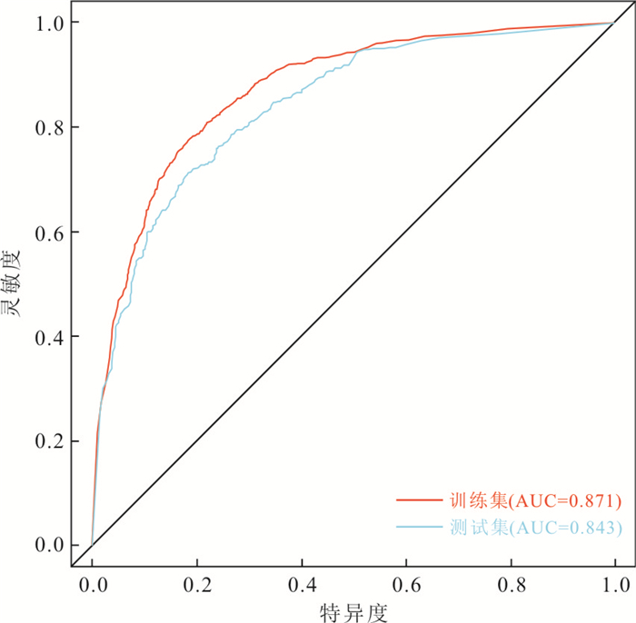
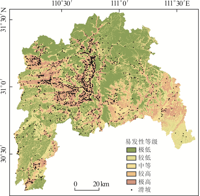
摘要: 滑坡空间易发性分析有助于开展滑坡防灾减灾工作,训练有效的滑坡预测模型在其中扮演重要角色.以三峡库区湖北段为研究区,选取高程、坡度、斜坡结构、土地利用类型、岩土体类型、断裂距离、路网距离、河网距离、以及归一化植被指数这9个影响因子建立滑坡空间数据库,采用集成学习中的随机森林算法进行滑坡易发性评价.结果显示,随机森林抽样训练的方式有利于确定较优的训练参数,保证随机森林在不过拟合的情况下取得满意的拟合能力和泛化能力.随机森林绘制的滑坡易发性分级图显示出合理的空间分布,其中73.35%的滑坡分布在较高和极高级别区域.而巴东县北部、秭归县中部以及夷陵区南部等区域显示出较高的易发性级别.性能评估及易发性统计结果均表明随机森林是一种出色的算法,在滑坡空间预测领域具有较好的适用性.Abstract: Landslide spatial susceptibility assessment can assist to conduct the prevention and mitigation of landslides,in which the application of effective landslide models plays a significant role. Taking Hubei section of the Three Gorges Reservoir Area as study area,nine influencing factors including elevation,slope angle,slope structure,land use,engineering rock group,distance to faults,distance to roads,distance to rivers,and normalized difference vegetation index were selected to to establish the landslide spatial database.Then the random forest ensemble algorithm was used to assess landslide susceptibility. The results show that the sampling training scheme of random forest benefits to search suitable training parameters,and enables the random forest achieve desirable fitting ability and generalization skill when avoiding the over-fitting problem. The landslide susceptibility mapping results developed by random forest show a reasonable spatial distribution,where 73.35% of the landslides are located in highly and very highly susceptible areas. Furthermore,the areas of northern Badong county,central Zigui county and the southern Yiling district show a higher susceptibility level. The performance evaluation and statistical results of susceptibility show that the random forest is an excellent algorithm,and has a good applicability in the field of landslide spatial prediction.
-
Key words:
- landslide /
- susceptibility /
- random forest /
- Three Gorges reservoir area
-

图 2 随机森林OOB误差曲线图
Fig. 2. OOB error curves of random forest
a. mtry=2;b. mtry=3;c. mtry=4;d. mtry=5
表 1 评价因子汇总表
Table 1. The summary of conditioning factors
高程(m) 坡度(°) 斜坡结构 类别 PA(%) PL(%) FR 类别 PA(%) PL(%) FR 类别 PA(%) PL(%) FR ≤200 7.44 10.22 1.37 ≤5 6.22 2.47 0.40 水平坡 0.40 0.52 1.30 200~400 9.21 30.96 3.36 5~10 11.05 6.49 0.59 顺向坡 18.33 18.50 1.01 400~600 11.84 20.05 1.69 10~15 15.21 14.59 0.96 顺斜向坡 17.83 18.27 1.02 600~800 13.75 14.13 1.03 15~20 17.34 22.11 1.28 横向坡 32.79 33.20 1.01 800~1000 15.28 11.72 0.77 20~25 16.15 23.09 1.43 逆斜向坡 15.56 14.47 0.93 1 000~1 200 15.60 7.01 0.45 25~30 12.69 16.94 1.34 逆向坡 15.09 15.05 1.00 1 200~1 400 13.37 3.73 0.28 30~35 9.04 8.50 0.94 > 1 400 13.51 2.18 0.16 35~40 5.88 3.10 0.53 > 40 6.43 2.70 0.42 路网距离(m) NDVI 断裂距离(m) 类别 PA(%) PL(%) FR 类别 PA(%) PL(%) FR 类别 PA(%) PL(%) FR ≤50 15.99 30.96 1.94 ≤-0.1 2.12 3.27 1.54 ≤1000 19.75 17.92 0.91 50~100 12.52 21.65 1.73 -0.1~0 1.85 2.81 1.52 1 000~2 000 16.07 13.10 0.81 100~200 17.96 22.63 1.26 0~0.1 4.53 6.66 1.47 2 000~3 000 12.68 10.45 0.82 200~300 11.97 9.88 0.83 0.1~0.2 10.27 11.60 1.13 3 000~4 000 9.63 8.62 0.89 300~400 8.36 5.05 0.60 0.2~0.3 19.00 17.69 0.93 4 000~5 000 7.74 6.72 0.87 400~500 6.11 3.22 0.53 0.3~0.4 27.02 23.95 0.89 5 000~6 000 6.59 8.27 1.26 500~600 4.66 1.84 0.39 0.4~0.5 25.24 23.43 0.93 6 000~7 000 5.71 9.25 1.62 600~700 3.60 1.03 0.29 > 0.5 9.96 10.57 1.06 7 000~8 000 4.85 5.51 1.14 700~800 2.91 1.21 0.41 8 000~9 000 4.10 4.77 1.16 > 800 15.91 2.53 0.16 > 9 000 12.88 15.39 1.19 河网距离(m) 土地利用类型 岩土体类型 类别 PA(%) PL(%) FR 类别 PA(%) PL(%) FR 类别 PA(%) PL(%) FR ≤500 17.34 21.83 1.26 农地 14.38 17.98 1.25 松散岩土类 12.09 24.99 2.07 500~1 000 17.04 18.90 1.11 园地 6.68 22.80 3.41 碎屑岩类 21.63 38.94 1.80 1 000~1 500 15.72 14.88 0.95 居民地 2.97 8.90 3.00 碳酸盐岩类 52.40 29.47 0.56 1 500~2 000 13.33 9.13 0.69 林地 72.47 43.54 0.60 岩浆岩及变质岩类 13.88 6.61 0.48 2 000~2 500 10.30 8.39 0.81 草地 0.56 0.52 0.93 2 500~3 000 7.79 6.32 0.81 其它 2.95 6.26 2.12 3 000~3 500 5.65 6.84 1.21 > 3 500 12.84 13.73 1.07  下载: 导出CSV
表 2 随机森林性能统计表
Table 2. Performance of random forest
性能度量指标 准确度 均方根误差 kappa系数 训练集 0.791 0.390 0.582 测试集 0.753 0.417 0.507
下载: 导出CSV
表 3 易发性评价灾害点分布统计表
Table 3. The summary of landslide locations in corresponding susceptibility classes
易发性等级 滑坡数 滑坡百分比(%) 栅格数 栅格百分比(%) 滑坡密度 极高 1 040 58.47 1 839 800 14.57 4.01 较高 265 14.88 1 475 600 11.69 1.27 中等 218 12.23 1 695 650 13.43 0.91 较低 125 7.00 2 232 150 17.68 0.40 极低 132 7.41 5 382 825 42.63 0.17
下载: 导出CSV
-
Aditian, A., Kubota, T., Shinohara, Y., 2018. Comparison of GIS-Based Landslide Susceptibility Models Using Frequency Ratio, Logistic Regression, and Artificial Neural Network in a Tertiary Region of Ambon, Indonesia. Geomorphology, 318:101-111. https://doi.org/10.1016/j.geomorph.2018.06.006 Alcántara-Ayala, I., 2002. Geomorphology, Natural Hazards, Vulnerability and Prevention of Natural Disasters in Developing Countries. Geomorphology, 47(2/3/4):107-124. https://doi.org/10.1016/s0169-555x(02)00083-1 Bennett, G. L., Miller, S. R., Roering, J. J., et al., 2016. Landslides, Threshold Slopes, and the Survival of Relict Terrain in the Wake of the Mendocino Triple Junction. Geology, 44(5):363-366. https://doi.org/10.1130/g37530.1 Breiman, L., Friedman, J. H., Olshen, R. A., et al., 1984. Classification and Regression Trees. Chapman & Hall, New York. Breiman, L., 2001. Random Forests. Machine Learning, 45(1):5-32. https://doi.org/10.1023/A:1010933404324. Feng, H.J., Zhou, A.G., Yu, J.J., et al., 2016. A Comparative Study on Plum-Rain-Triggered Landslide Susceptibility Assessment Models in West Zhejiang Province. Earth Science, 41(3):403-415 (in Chinese with English abstract). http://en.cnki.com.cn/Article_en/CJFDTOTAL-DQKX201603006.htm Felicísimo, Á. M., Cuartero, A., Remondo, J., et al., 2013. Mapping Landslide Susceptibility with Logistic Regression, Multiple Adaptive Regression Splines, Classification and Regression Trees, and Maximum Entropy Methods:A Comparative Study. Landslides, 10(2):175-189. https://doi.org/10.1007/s10346-012-0320-1 Fenti, V., Silvano, S., Spagna, V., 1979. Methodological Proposal for an Engineering Geomorphological Map. Forecasting Rockfalls in the Alps. Bulletin of the International Association of Engineering Geology, 19(1):134-138. https://doi.org/10.1007/bf02600465 Guo, H.J., Tang, N.Q., Lin, J.B., 2010. Sensibility Analysis of Land-Use and Landslide Hazard Based on GIS in Xianyou County. Journal of Fujian Agriculture and Forestry University (Natural Science Edition), 39(4):417-420 (in Chinese with English abstract). http://www.cabdirect.org/abstracts/20103284954.html;jsessionid=4FA7BBD33F5E271F97960BEF557B26B0 Guo, Z.Z., Yin, K.L., Fu, S., et al., 2018. Evaluation of Landslide Susceptibility Based on GIS and WOE-BP Model. Earth Science, 44(12):4299-4312 (in Chinese with English abstract). http://www.researchgate.net/publication/324390254_Evaluation_of_Landslide_Susceptibility_Based_on_GIS_and_WOE-BP_Model Guo, Z.Z., Yin, K.L., Liu, Q.L., et al., 2019. Rainfall Warning of Creeping Landslide in Yunyang County of Three Gorges Reservoir Region Based on Displacement Ratio Model. Earth Science, 45(2):672-684 (in Chinese with English abstract). Jiang, R., 2010. Research on Generation Mechanism and Service of Slope Disaster Warning Information in Kunming City(Dissertation). Kunming University of Science and Technology, Kunming (in Chinese with English abstract). Kornejady, A., Ownegh, M., Bahremand, A., 2017. Landslide Susceptibility Assessment Using Maximum Entropy Model with Two Different Data Sampling Methods. CATENA, 152:144-162. https://doi.org/10.1016/j.catena.2017.01.010 Li, S.L., Xu, Q., Tang, M.G., et al., 2018. Study on Spatial Distribution and Key Influencing Factors of Landslides in Three Gorges Reservoir Area. Earth Science, 45(1):341-354 (in Chinese with English abstract). Li, Y.Y., Mei, H.B., Ren, X.J., et al., 2018.Geological Disaster Susceptibility Evaluation Based on Certainty Factor and Support Vector Machine. Journal of Geo-Information Science, 20(12):1699-1709 (in Chinese with English abstract). http://en.cnki.com.cn/Article_en/CJFDTotal-DQXX201812003.htm Liu, L.N., Xu, C., Xu, X.W., et al., 2014. GIS-Based Landslide Hazard Evaluation Using AHP Method in the 2013 Lushan Earthquake Region. Journal of Catastrophology, 29(4):183-191 (in Chinese with English abstract). http://en.cnki.com.cn/Article_en/CJFDTotal-ZHXU201404037.htm Nie, J., Lian, J., Hu, Z.W., 2014. Spatial Variation of Landslides in Wenchuan Earthquake-Stricken Areas. Geographical Research, 33 (2):214-224 (in Chinese with English abstract). http://en.cnki.com.cn/Article_en/CJFDTOTAL-DLYJ201402003.htm Shi, X.G., Xu, J.H., Jiang, H.J., et al., 2019. Slope Stability State Monitoring and Updating of the Outang Landslide, Three Gorges Area with Time Series InSAR Analysis. Earth Science, 44(12):4284-4292 (in Chinese with English abstract). http://en.cnki.com.cn/Article_en/CJFDTotal-DQKX201912038.htm Pham, B. T., Pradhan, B., Tien Bui, D., et al., 2016. A Comparative Study of Different Machine Learning Methods for Landslide Susceptibility Assessment:A Case Study of Uttarakhand Area (India). Environmental Modelling & Software, 84:240-250. https://doi.org/10.1016/j.envsoft.2016.07.005 Song, Y. Q., Gong, J. H., Gao, S., et al., 2012. Susceptibility Assessment of Earthquake-Induced Landslides Using Bayesian Network:A Case Study in Beichuan, China. Computers & Geosciences, 42:189-199. https://doi.org/10.1016/j.cageo.2011.09.011 Tehrany, M. S., Pradhan, B., Jebur, M. N., 2013. Spatial Prediction of Flood Susceptible Areas Using Rule Based Decision Tree (DT) and a Novel Ensemble Bivariate and Multivariate Statistical Models in GIS. Journal of Hydrology, 504:69-79. https://doi.org/10.1016/j.jhydrol.2013.09.034 Wang, L.L., 2016. Feature Processing Method in Rainfall-induced Landslide Susceptibility Assessment (Dissertation). Zhejiang University, Hangzhou (in Chinese with English abstract). Wu, S., Li, L.W., Li, S.J., 2012. Analysis on the Influence of Coupling Relationship between Rock Mass Structural Plane and Water on Slope Stability. Journal of Jingchu University of Technology, 27(2):33-36 (in Chinese with English abstract). Wu, X.L., Shen, S.Q., Niu, R.Q., 2016. Landslide Susceptibility Prediction Using GIS and PSO-SVM. Geomatics and Information Science of Wuhan University, 41(5):665-671 (in Chinese with English abstract). http://en.cnki.com.cn/Article_en/CJFDTotal-WHCH201605015.htm Xiang, L.Z., Cui, P., 2014. Triggering Factors Susceptibility of Earthquake-Induced Collapses and Landslides in Wenchuan County. Journal of Sichuan University (Engineering Science Edition), 42(5):105-112 (in Chinese with English abstract). http://www.researchgate.net/publication/289748349_Triggering_factors_susceptibility_of_earthquake-induced_collapses_and_landslides_in_Wenchuan_County Xiao T., 2007. GIS-Based Research on Spatial Simulation of Landslide in Lanzhou City (Dissertation). Lanzhou University, Lanzhou (in Chinese with English abstract). Zare, M., Pourghasemi, H. R., Vafakhah, M., et al., 2013. Landslide Susceptibility Mapping at Vaz Watershed (Iran) Using an Artificial Neural Network Model:A Comparison between Multilayer Perceptron (MLP) and Radial Basic Function (RBF) Algorithms. Arabian Journal of Geosciences, 6(8):2873-2888. https://doi.org/10.1007/s12517-012-0610-x 冯杭建, 周爱国, 俞剑君, 等, 2016.浙西梅雨滑坡易发性评价模型对比.地球科学, 41(3):403-415. doi: 10.3799/dqkx.2016.032 郭慧娟, 唐南奇, 林金宝, 2010.基于GIS的仙游县土地利用与滑坡灾害敏感性分析.福建农林大学学报(自然科学版), 39(4):417-420. https://www.cnki.com.cn/Article/CJFDTOTAL-FJND201004018.htm 郭子正, 殷坤龙, 付圣, 等, 2018.基于GIS与WOE-BP模型的滑坡易发性评价.地球科学, 44(12):4299-4312. doi: 10.3799/dqkx.2016.032 郭子正, 殷坤龙, 刘庆丽, 等, 2019.基于位移比模型的三峡库区云阳县域内蠕变型滑坡降雨预警.地球科学45(2):672-684. doi: 10.3799/dqkx.2019.005 蒋锐, 2010.昆明市斜坡灾害预警信息生成机理及服务研究(博士学位论文).昆明: 昆明理工大学. 李松林, 许强, 汤明高, 等, 2018.三峡库区滑坡空间发育规律及其关键影响因子.地球科学, 45(1):341-354. doi: 10.3799/dqkx.2017.576 李远远, 梅红波, 任晓杰, 等, 2018.基于确定性系数和支持向量机的地质灾害易发性评价.地球信息科学学报, 20(12):1699-1709. doi: 10.12082/dqxxkx.2018.180349 刘丽娜, 许冲, 徐锡伟, 等, 2014. GIS支持下基于AHP方法的2013年芦山地震区滑坡危险性评价.灾害学, 29(4):183-191. doi: 10.3969/j.issn.1000-811X.2014.04.034 聂娟, 连健, 胡卓玮, 2014.汶川地震灾区滑坡空间特征变化分析.地理研究, 33(2):214-224. https://www.cnki.com.cn/Article/CJFDTOTAL-DLYJ201402003.htm 史绪国, 徐金虎, 蒋厚军, 等, 2019.时序InSAR技术三峡库区藕塘滑坡稳定性监测与状态更新.地球科学, 44(12):4284-4292. doi: 10.3799/dqkx.2019.180 王丽丽, 2016.降雨型滑坡地质灾害易发性评价中的特征处理方法.杭州: 浙江大学. 武尚, 李利文, 李世佳, 2012.岩体结构面与水耦合关系对边坡稳定性的影响分析.荆楚理工学院学报, 27(2):33-36 doi: 10.3969/j.issn.1008-4657.2012.02.007 武雪玲, 沈少青, 牛瑞卿, 2016. GIS支持下应用PSO-SVM模型预测滑坡易发性.武汉大学学报(信息科学版), 41(5):665-671. https://www.cnki.com.cn/Article/CJFDTOTAL-WHCH201605015.htm 向灵芝, 崔鹏, 2014.汶川县地震诱发崩滑灾害影响因素的敏感性分析.四川大学学报(工程科学版), 42(5):105-112. https://www.cnki.com.cn/Article/CJFDTOTAL-SCLH201005016.htm 肖桐, 2007.基于GIS的兰州市滑坡空间模拟研究(硕士学位论文).兰州: 兰州大学. -

 点击查看大图

计量
- 文章访问数: 2841
- HTML全文浏览量: 1828
- PDF下载量: 183
- 被引次数: 0
