


Changes of Water Resources amount in Dongting Lake before and after the Operation of the Three Gorges Reservoir
-
摘要: 为研究三峡水库运行前后洞庭湖水资源量变化情况,通过利用1994-2019年165个时相的多平台中高分辨率(15~30 m)卫星遥感数据,城陵矶多年日观测水位数据和洞庭湖区降水量、蒸发量等资料,采用掩膜处理、K-Means聚类分析提取水面信息,结合观测数据进行统计分析,研究了1994年以来洞庭湖水面面积与湖容变化情况.结果表明:三峡水库运行后洞庭湖年均水面面积由1 077.46 km2减少到857.13 km2,减幅达20.45%,但是2011年后当城陵矶水位大于26.34 m时水面有所增加;三峡水库对下泄量的调控在缓解洞庭湖洪涝灾害隐患的同时,也使得低枯水位提前1个月,且对洞庭湖枯水期的补给水量极其有限;三峡水库运行后洞庭湖湖容明显减小,且当城陵矶水位越高时,洞庭湖湖容减幅越大;当水位小于20 m时三峡水库运行前后两个时段的湖容逐渐接近.洞庭湖水资源量变化主要受出入湖径流影响,"四水"径流是影响洞庭湖水资源量的主要因素,"三口"径流的减少也对洞庭湖水资源量的变化起着重要作用.同时,湖区年均降水量的减少和蒸发量的增加也是引起洞庭湖水资源量减少的原因之一.研究成果为三峡工程运行后治湖思路调整、洞庭湖区水资源保护和长江流域生态修复提供了客观资料.Abstract: In order to study the changes of water resources amount in Dongting Lake before and after the operation of the Three Gorges Reservoir, this research used 165 multi platform high-resolution (15-30 m) satellite remote sensing data of 1994-2019, combined with the daily observation water level data of Chenglingji for many years and the data of precipitation and evaporation in Dongting Lake area, the water surface information extracted by mask processing and K-means clustering analysis, studies the changes of water surface area and lake capacity of Dongting Lake since 1994. Theoperation of the Three Gorges Reservoir significantly influenced the changes of water resources in Dongting Lake. In this study, 165 multi-platform satellite data were combined with the daily hydrological and meteorological data to explore the changes of water area and lake capacity of Dongting Lake since 1994. The water surface information was extracted by using mask processing and K-means clustering analysis. Results showed that:after the operation of the Three Gorges reservoir, the annual average water surface area decreased from 1 077.46 km2 to 857.13 km2, with a decrease of 20.45% at the water level in Chenglingji was more than 26.34 m after 2011.At the same time, the regulation of the Three Gorges reservoir not only alleviated the hidden danger of the flood disaster of Dongting Lake, but also advanced the dry water level by one month. In addition, the supply water for Dongting Lake was extremely limited during low water level period. After the operation of the Three Gorges Reservoir, the lake capacity of the Dongting Lake was significantly reduced, especially the higher the water level, the greater the reduction; When the water level is less than 20 m, the lake capacity gradually approaches during the before and after operation periods of the Three Gorges Reservoir. The change of water resources of Dongting Lake is mainly affected by the inflow of the lake.The runoff of "four waters" was the main factor determining the water resources of Dongting Lake, but the reduction of runoff of "three outlets" also playedan important role. At the same time, the decrease of annual precipitation and the increase of evaporation were also the reasons for the decrease of water resources in Dongting Lake. The research results provided objective data for the adjustment of lake management ideas, the protection of water resources in Dongting Lake area and the ecological restoration of the Yangtze River basin after the operation of the Three Gorges Reservoir.
-
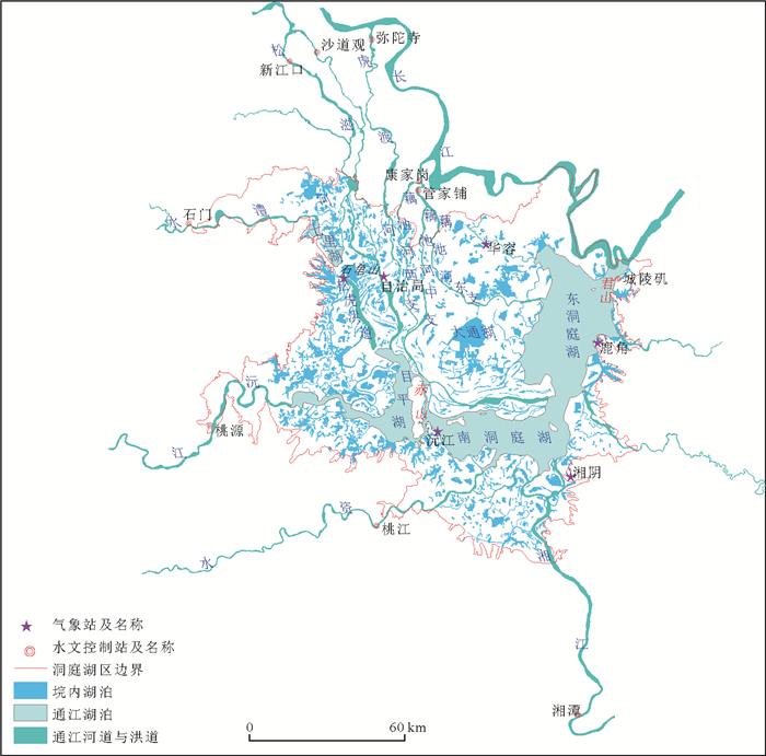
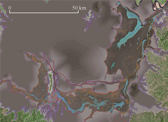
图 1 洞庭湖区通江湖泊与垸内湖泊分布
Fig. 1. Distribution map of lake connecting to the Yangtze River and inner embankment in Dongting Lake area
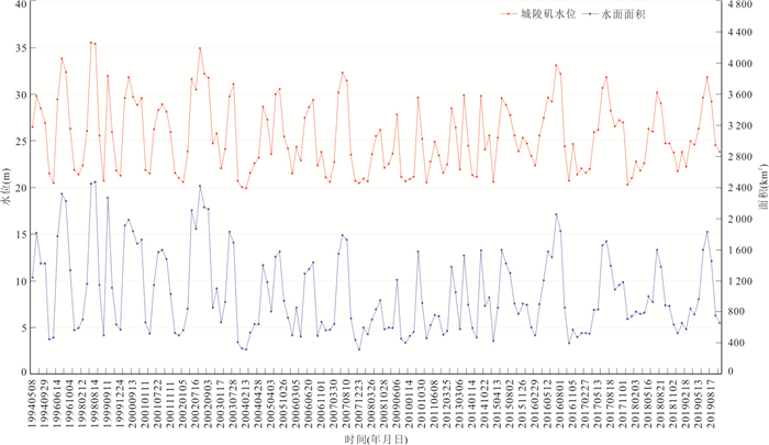
图 2 1994—2019年洞庭湖水位与水面面积变化关系
Fig. 2. Relationship between water level and surface area of Dongting Lake from 1994 to 2019
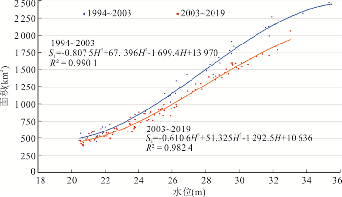
图 3 三峡水库运行前后洞庭湖水面面积-水位关系曲线
Fig. 3. Relationship curve between water surface area-water level of Dongting Lake before and after operation of Three Gorges Reservoir

图 4 三峡水库运行后不同时段洞庭湖水面面积-水位关系曲线
Fig. 4. Relationship curve between water surface area-water level of Dongting Lake in different periods after operation of Three Gorges Reservoir
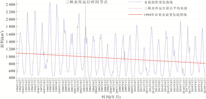
图 5 1994—2019年洞庭湖水面面积年际变化
Fig. 5. Inter-annual change in water surface area of Dongting Lake during 1994 to 2019

图 6 三峡水库运行前后月均水面面积变化曲线
Fig. 6. Change curve of monthly average water surface area before and after operation of Three Gorges Reservoir

图 7 三峡水库运行前后特征水面面积变化曲线
Fig. 7. Change curve of characteristic water surface area before and after operation of Three Gorges Reservoir
图 9 漫滩湖容求算原理示意图
Fig. 9. Schematic diagram of flood plain and lake capacity calculation
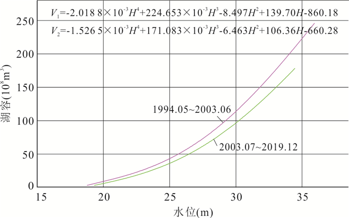
图 10 三峡水库运行前后洞庭湖湖容与城陵矶水位关系曲线
Fig. 10. Relation curve between lake capacity and water level of Chenglingji before and after operation of Three Gorges Reservoir
表 1 三峡水库运行前后洞庭湖特征水位下的湖容对比
Table 1. Comparison of lake capacity under characteristic water level of Dongting Lake before and after operation of Three Gorges
1994.5—2003.6 2003.7—2019.10 湖容增减 2003.7—2010.12 2011.1—2019.10 湖容增减 备注 水位 湖容 水位 湖容 水位 湖容 水位 湖容 18.77 3.42 18.77 3.42 无变化 18.77 3.42 18.77 3.42 无变化 底水水位,公式不适应 21.49 16.89 21.62 13.66 -3.23 21.62 13.87 21.62 13.77 -0.10 枯水期平均水位及其湖容 24.78 41.16 24.51 32.17 -8.99 24.51 32.65 24.51 32.49 -0.16 平水期平均水位及其湖容 25.49 48.35 25.00 36.23 -12.12 25.00 36.73 25.00 36.55 -0.18 各时段平均水位及其湖容 29.75 109.37 28.70 77.45 -31.92 28.70 77.90 28.70 78.11 0.21 洪水期平均水位及其湖容 32.50 164.73 32.50 139.77 -24.96 32.50 138.89 32.50 141.51 2.62 洞庭湖警戒水位及其湖容 33.50 187.36 33.50 159.06 -28.30 33.50 157.46 33.50 161.29 3.83 洞庭湖防汛水位及其湖容 35.94 246.03 35.94 209.47 -36.56 35.94 205.15 35.94 213.34 8.19 历史最高水位及其湖容 注:水位单位为m;湖容单位为108 m3.  下载: 导出CSV
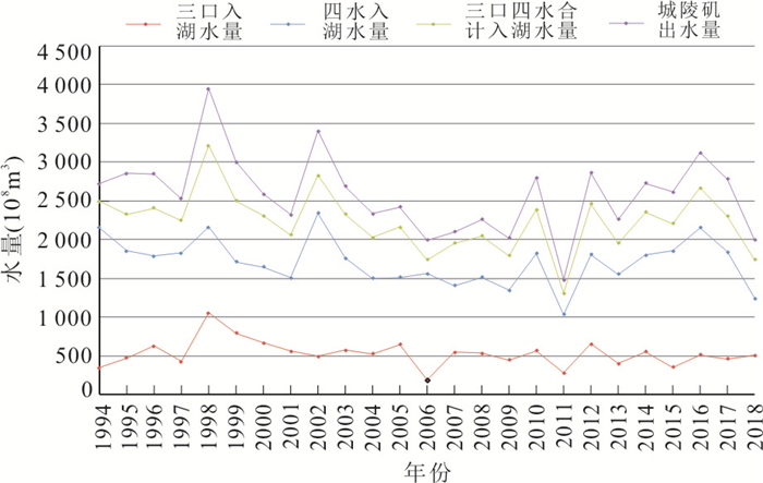
表 2 1994—2018年洞庭湖年均径流量出入对比
Table 2. Comparison of annual inflow and outflow of Dongting Lake from 1994 to 2018
年均出入径流量 三峡水库运行前后
(1994—2018)三峡水库运行前
(1994—2003)三峡水库运行后
(2004—2018)三峡水库运行后
出入径流减少量减少幅度
(%)三口年均入湖径流 524.21 596.97 487.71 109.26 18.30 四水年均入湖径流 1 704.46 1 870.61 1 593.69 276.92 14.80 年均入湖径流总量 2 211.97 2 467.58 2 081.40 386.18 15.65 城陵矶年均出湖径流 2 583.00 2 886.00 2 381.00 505.00 17.50 注:湖容单位为108 m3.
下载: 导出CSV
表 3 三峡水库运行前后洞庭湖区年均降水量变化
Table 3. Change of annual precipitation in Dongting Lake area before and after operation of Three Gorges
水文站 时间段 三峡水库运行前(1994—2003) 三峡水库运行后(2003—2018) 减小量 减小幅度(%) 鹿角 4~8月份 950.32 809.55 140.77 14.81 其他月份 487.82 451.12 36.70 7.52 年均降水量 1 438.14 1 260.67 177.47 12.34 沅江 4~8月份 888.73 790.48 98.25 11.06 其他月份 479.63 449.79 29.84 6.22 年均降水量 1 368.36 1 240.27 128.09 9.36 石龟山 4~8月份 890.27 838.42 51.85 5.82 其他月份 420.62 409.74 10.88 2.59 年均降水量 1 310.89 1 248.16 62.73 4.79 自治局 4~8月份 865.12 854.44 10.68 1.23 其他月份 391.25 390.07 1.18 0.30 年均降水量 1 256.37 1 244.51 11.86 0.94 平均降水量 4~8月份 898.61 823.22 75.39 8.39 其他月份 444.83 425.18 19.65 4.42 年均降水量 1 343.44 1 288.40 95.04 7.07
下载: 导出CSV
表 4 三峡水库运行前后洞庭湖区年均蒸发量变化
Table 4. Change of annual average evaporation in Dongting Lake area before and after operation of Three Gorges
气象站 时间段 三峡水库运行前(1994—2003) 三峡水库运行后(2003—2018) 变化量 变化幅度 湘阴 4~8月份 570.23 600.42 30.19 5.29% 其他月份 245.21 261.19 15.98 6.52% 年均蒸发量 815.44 861.61 46.17 5.66% 沅江 4~8月份 569.52 589.63 20.11 3.53% 其他月份 254.25 300.39 46.14 18.15% 年均蒸发量 823.77 890.02 66.25 8.04% 安乡 4~8月份 481.86 478.72 -3.14 -0.65% 其他月份 225.28 220.66 -4.62 -2.05% 年均蒸发量 707.14 699.38 -7.76 -1.10% 华容 4~8月份 500.61 559.22 58.61 11.71% 其他月份 223.51 248.64 25.13 11.24% 年均蒸发量 724.12 807.86 83.74 11.56% 平均蒸发量 4~8月份 530.56 557.00 26.44 4.98% 其他月份 237.06 257.72 20.66 8.72% 年均蒸发量 767.62 814.72 47.10 6.14%
下载: 导出CSV
-
Chen, B.S., 1986. Comprehensive Investigation Report on Harnessing and Development of Dongting Lake Area. Office of Hunan Provincial Land Commision, Changsha, 18-20 (in Chinese with English abstract). Cui, L., Liu, Y.P., Huang, G.H., et al., 2015. Dynamic Changes of Dongting Lake Based on Landsat-TM Remote Sensing Data. South-to-North Water Transfers and Water Science & Technology, 13(1):63-66 (in Chinese with English abstract). http://www.cnki.com.cn/Article/CJFDTotal-NSBD201501019.htm Du, Y.Y., Zhou, C.H., 1998. Automatically Extracting Remote Sensing Information for Water Bodies. Journal of Remote Sensing, 2(4):264-269 (in Chinese with English abstract). http://en.cnki.com.cn/Article_en/CJFDTOTAL-YGXB804.005.htm Gert, A.S., Edwin, T.E., 2006.The Remote-Sensing Technique in Hydrology and Water Management. Translated by Han Min. China Water Power Press, Beijing, 9-10, 127-132 (in Chinese). Gong, W., Yang, D.W., Qian, Q., 2009. MODIS-Based Water Surface Area Estimation Method of the Dongting Lake. Yangtze River, 40(14):40-43 (in Chinese with English abstract). http://en.cnki.com.cn/Article_en/CJFDTOTAL-RIVE200914015.htm Gui, H.H., Zhang, W.J., Zou, B.Y., 2014. Effects of Three Gorges Reservoir Scheduling Scheme on Downstream Flood Level. Electric Power Survey & Design, 2:25-28 (in Chinese with English abstract). http://en.cnki.com.cn/Article_en/CJFDTotal-DLKC201402011.htm Hu, J.J., Zhang, Y., Li, P., 2017. Analysis of the Variation of Water Area in Dongting Lake Based on Modis Data. Journal of Heilongjiang Institute of Technology, 31(2):25-29 (in Chinese with English abstract). http://en.cnki.com.cn/Article_en/CJFDTOTAL-JTGZ201702007.htm Huang, Z.L., Wu, B.F., Ao, L.G., 2006. Study on the Ecological and Environmental Monitoring System of the Three Gorges Project. Science Press, Beijing (in Chinese). Ji, H.X., Fan, X.W., Wu, G.P., et al., 2015. Accuracy Comparison and Analysis of Methods for Water Area Extraction of Discrete Lakes. Journal of Lake Sciences, 27(2):327-334 (in Chinese with English abstract). doi: 10.18307/2015.0218 Ke, W.L., Chen, C.Z., Ji, H.X., et al., 2017. A Loop-Like Relationship Between Water Surface Area of Lake Dongting and Water Level and Chenglingji, the Yangzte River. Journal of Lake Sciences, 29(3):753-764 (in Chinese with English abstract). doi: 10.18307/2017.0325 Li, J.G., Li, J.R., Huang, S.F., et al., 2010. The Remote Sensing Monitoring Analysis of Chinese Dongting Lake Water Area Variations in Last 10 Years Using Terra/MODIS Data Time Series. Journal of China Institute of Water Resources & Hydropower Research, 8(3):201-207 (in Chinese with English abstract). http://en.cnki.com.cn/Article_en/CJFDTOTAL-ZGSX201003011.htm Li, X.D., Liu, J.J., 2006.Hydrography of Hunan Province. China Water & Power Press, Beijing, 42 (in Chinese with English abstract). Li, Y.L., 2014. A Brief History of the Evolution, Development and Management of Dongting Lake. Hunan University Press, Changsha, 3-4 (in Chinese). Li, Y.Y., Cao, J.T., Huang, H.J., 2018. International Progresses in Integrated Water Resources Management. Advances in Water Science, 29(1):127-137 (in Chinese with English abstract). http://www.researchgate.net/publication/327963871_International_progresses_in_integrated_water_resources_management Liu, K.Q., Liang, Y.T., Huang, J., et al., 2009. Analysis of the Variations and Influencing Factors of Area in Dongting Lake Based on Remote Sensing Satellite. Chinese Journal of Agrometeorology, 30(S2):281-284 (in Chinese with English abstract). http://en.cnki.com.cn/Article_en/CJFDTOTAL-ZGNY2009S2027.htm Song, Q.M., Xiong, L.H., Xiao, Y., et al., 2011. Study on Relationship between Lake Area and Water Level of Dongting Lake Based on MODIS Images.Water Saving Irrigation, 6:20-26 (in Chinese with English abstract). Tian, W.G., Peng, J.D., Shen, J., et al., 2012. Sequence Analysis on the Area of Dongting Lake before and after Building Three Gorges Dame Based on MODIS Image Sequences. Journal of Anhui Agri., 40(16):9141-9145 (in Chinese with English abstract). http://en.cnki.com.cn/Article_en/CJFDTOTAL-AHNY201216130.htm Tong, Q.M., Han, W., Lei, F., et al., 2014. The Comparative Study about Solution of Seasonally Water Shortage in Dongting Lake. Hunan University Press, Changsha, 31-36 (in Chinese). Wang, K.Y., 1998. Management and Development of the Dongting Lake. Hunan People Press, Changsha, 33-36 (in Chinese). Xiang, F.F., Wang, L.C., Yao, R., et al., 2018. The Characteristics of Climate Change and Response of Vegetation in Three Gorges Reservoir Area. Earth Science, 43(Suppl. 1):42-52 (in Chinese with English abstract). http://en.cnki.com.cn/Article_en/CJFDTotal-DQKX2018S1005.htm Xie, W.J., Yue, C.Y., Zhang, W., 2017. Study on Change of Temporal and Spatial Characteristic of Dongting Lake from 1996 to 2016. Water Resources Information, 5:32-38 (in Chinese with English abstract). http://en.cnki.com.cn/Article_en/CJFDTOTAL-SLSW201705008.htm Yu, D.Q., Yu, S.C., He, Q.H., et al., 2016. Monitoring of Dongting Lake Atrophy in One Hundred Years byjointing Historical Map and Remote Sensing Technology. Remote Sensing for Land and Resources, 23(1):78-81 (in Chinese with English abstract). http://en.cnki.com.cn/Article_en/CJFDTotal-GTYG201603019.htm Yu, S.C., Yu, D.Q., Wang, L.C., et al., 2019. Remote Sensing Study of Dongting Lake Beach Changes before and after Oepration of Three Gorges Reservoir. Earth Science, 44(12):4275-4283 (in Chinese with English abstract). http://en.cnki.com.cn/Article_en/CJFDTotal-DQKX201912037.htm Zhong, Z.Y., Ning, L., 2008. Analysis of Flood Control Situation in the Middle and Lower Reaches of the Yangtze River after the Completion of the Three Gorges Project. China Water Resources, 15:18-20 (in Chinese with English abstract). 陈宝顺, 1986.洞庭湖区整治开发综合考察研究报告.长沙:湖南省国土委员会办公室, 18-20. 崔亮, 刘永平, 黄国和, 等, 2015.基于Landsat-TM影像的洞庭湖水面动态变化.南水北调与水利科技, 13(1):63-66. https://www.cnki.com.cn/Article/CJFDTOTAL-NSBD201501019.htm 杜云艳, 周成虎, 1998.水体的遥感信息自动提取方法.遥感学报, 2(4):264-269. https://www.cnki.com.cn/Article/CJFDTOTAL-YGXB804.005.htm Gert, A. S., Edwin, T. E., 2006.韩敏译.水文与水管理中的遥感技术.北京: 中国水利水电出版社, 9-10, 127-132. 龚伟, 杨大文, 钱群, 2009.基于MODIS数据的洞庭湖水面面积估算方法.人民长江, 40(14):40-43. doi: 10.3969/j.issn.1001-4179.2009.14.015 桂红华, 张文杰, 邹冰玉, 2014.三峡水库调度对下游洪水位的影响分析.电力勘测设计, 2:25-28. https://www.cnki.com.cn/Article/CJFDTOTAL-DLKC201402011.htm 黄真理, 吴炳方, 敖良桂, 2006.三峡工程生态与环境监测系统研究.北京:科学出版社. 胡金金, 张艳, 李鹏, 2017.基于MODIS数据的洞庭湖水体面积变化分析.黑龙江工程学院学报, 31(2):25-29. https://www.cnki.com.cn/Article/CJFDTOTAL-JTGZ201702007.htm 吉红霞, 范兴旺, 吴桂平, 等, 2015.离散型湖泊水体提取方法精度对比分析.湖泊科学, 27(2):327-334. https://www.cnki.com.cn/Article/CJFDTOTAL-FLKX201502018.htm 柯文莉, 陈成忠, 吉红霞, 等, 2017.洞庭湖水面面积与城陵矶水位之间的绳套关系.湖泊科学, 29(3):753-764. https://www.cnki.com.cn/Article/CJFDTOTAL-FLKX201703025.htm 李景刚, 李纪人, 黄诗峰, 等, 2010.近10年来洞庭湖区水面面积变化遥感监测分析.中国水利水电科学研究院学报, 8(3):201-207. doi: 10.3969/j.issn.1672-3031.2010.03.008 李晓德, 刘金军, 2006.湖南省水文志.北京:中国水利水电出版社, 42. 李跃龙, 2014.洞庭湖的演变、开发和治理简史.长沙:湖南大学出版社, 3-4. 李原园, 曹建廷, 黄火键, 2018.国际上水资源综合管理进展.水科学进展, 29(1):127-137. https://www.cnki.com.cn/Article/CJFDTOTAL-SKXJ201801017.htm 刘可群, 梁益同, 黄靖, 等, 2009.基于卫星遥感的洞庭湖水体面积变化及影响因子分析.中国农业气象, 30(增刊2):281-284. https://www.cnki.com.cn/Article/CJFDTOTAL-ZGNY2009S2027.htm 宋求明, 熊立华, 肖义, 等, 2011.基于MODIS遥感影像的洞庭湖面积与水位关系研究.节水灌溉, 6:20-26. https://www.cnki.com.cn/Article/CJFDTOTAL-JSGU201106008.htm 田伟国, 彭嘉栋, 沈军, 等, 2012.基于MODIS影像序列的三峡截流前后洞庭湖面积变化序列分析.安徽农业科学, 40(16):9141-9145. doi: 10.3969/j.issn.0517-6611.2012.16.129 童潜明, 韩伟, 雷帆, 等, 2014.解决洞庭湖区季节性缺水方案比较研究.长沙:湖南大学出版社, 31-36. 王克英, 1998.洞庭湖治理与开发.长沙:湖南人民出版社, 33-36. 向菲菲, 王伦澈, 姚瑞, 等, 2018.三峡库区气候变化特征及其植被响应.地球科学, 43(增刊1):42-52. doi: 10.3799/dqkx.2018.912 谢文君, 岳翠莹, 张文, 2017.洞庭湖1994-2016年时空特征变化研究.水利信息化, 5:32-38. https://www.cnki.com.cn/Article/CJFDTOTAL-SLSW201705008.htm 余德清, 余姝辰, 贺秋华, 等, 2016.联合历史地图与遥感技术的洞庭湖百年萎缩监测.国土资源遥感, 23(1):78-81. https://www.cnki.com.cn/Article/CJFDTOTAL-GTYG201603019.htm 余姝辰, 余德清, 王伦澈, 等, 2019.三峡水库运行前后洞庭湖洲滩面积变化遥感认识.地球科学, 44(12): 4275-4283. doi: 10.3799/dqkx.2019.182 仲志余, 宁磊, 2008.三峡工程建成后再遇98大洪水长江中下游防洪形势分析.防汛与抗旱, 15:18-20. https://www.cnki.com.cn/Article/CJFDTOTAL-SLZG200815009.htm -

 点击查看大图
计量
- 文章访问数: 2465
- HTML全文浏览量: 564
- PDF下载量: 126
- 被引次数: 0
