


Inversion of Sea Surface Flow Field in Southern South China Sea Based on Satellite Remote Sensing Data
-
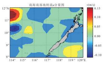
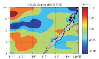
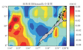
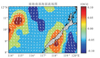
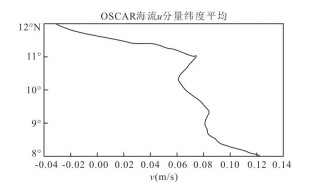
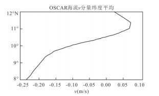
摘要: 海表流场可直接影响海表的气候变化,且对于研究海气相互作用、热通量输送等具有重要意义.通过利用Jason-2号与HY-2号卫星高度计数据以及Metop卫星的ASCAT与HY-2号卫星散射计数据反演海表流场.利用距离加权平均法生成分辨率为0.25°×0.25°的网格,通过数据融合分别得到海表高度场与海面风场,在此基础上构建地转流和Ekman流反演数学模型.利用Jason-2与HY-2号卫星高程计数据反演地转流,利用ASCAT与HY-2号卫星散射计数据得出风应力驱动的Ekman流,合并两者得到海表流场.通过对研究海域海表流速的反演结果与OSCAR海流产品的对比分析,发现越靠近赤道的位置,其流速误差较大,最大相对误差达到了0.6 m/s.实验结果表明利用卫星遥感数据反演海洋表层流场能较为准确地表现实际海表流场的基本特征.Abstract: The sea surface flow field can directly affect the climate change of the sea surface,and is of great significance to the study of air-sea interaction and heat flux transfer. This paper uses altimeter data from Jason-2 and HY-2 satellite,scatterometer data from ASCAT of Metop and HY-2 satellite to estimate the sea surface flow field. The grid with resolution of 0.25°×0.25° is generated by the method of weighted average distance,the sea surface elevation field and wind field are obtained by data fusing. On this basis,the inversion mathematical models of the geostrophic flow and the Ekman flow are constructed. The geostrophic flow is retrieved from Jason-2 and Hy-2 altimeter data,and the wind-driven Ekman flow is obtained from the ASCAT and Hy-2 scatterometer data,the combination of both date results in the sea surface flow field. By comparing the inversion results of the sea surface flow in the study area with OSCAR current products,it is found that the closer to the equator,the greater the error of the velocity of the sea surface flow. The maximum relative error reached 0.6 m/s. The experimental results show that the sea surface flow field estimated by satellite remote sensing data can exactly describe the basic characters of actual sea surface flow field.
-
成矿作用过程中最活跃的因素莫过于成矿流体.成矿流体作用于成矿体系的各个单元是通过水/岩反应和物质交换, 与流体(无论是天水来源的地下水、封存海水、变质水或岩浆水) 的化学成分、物理化学条件、水动力环境、(热) 构造驱动机制等因素密切相关.研究云南思茅-南坪盆地边缘造山带金(铜) 成矿流体的动力学、地球化学、物理化学特征, 重建流体场及其运移、分布状态是了解成矿规律的重要途径.成矿元素在流体中的存在形式, 以及迁移过程中平衡-失稳、沉淀卸载机制是探讨矿床成因类型的关键.因而笔者特别重视成矿流体的来源、水动力环境、溶液的物理化学条件、金的迁移形式与沉淀机制研究.以最新的流体地质与成矿作用理论为指导, 应用古水文地质学、动力学分析和流体包裹体及稳定同位素等研究方法, 取得了区域成矿流体的地球化学系统资料.研究、观察范围和取样点见图 1.
 图 1 区域地质构造略图1.陆块; 2.南坪-思茅盆地; 3.子陆块边缘; 4.皱系; 5.印支板块边缘; 6.绿混杂岩带; 7.造推覆体Fig. 1. Regional geologic and tectonic sketch
1. 流体的来源
关于区域成矿流体的来源, 是一个颇有争议的问题.一般都认为成矿流体主要为变质水, 或主要为由变质水和大气降水形成的混合热液[2].由于区域火成活动较强, 成矿作用与火成岩有明显的空间关系, 因而也有学者认为该区成矿流体以岩浆热液或火山-次火山热液为主[3, 4].为了弄清成矿流体的性质和来源, 笔者分别对哀牢山金矿床石英包裹体水的氢氧同位素、碳酸盐矿物及碳酸盐岩的碳氧同位素进行研究, 并运用石英包裹体的He同位素, 探讨了南坪盆地金满铜金矿床的成矿物质来源.
1.1 氢氧同位素组成
石英包裹体水的H和O同位素组成如表 1.各矿区石英样品的O同位素组成范围为11.92×10⁻³~21.72×10⁻³, 平均值为17.12×10⁻³.根据石英的δ (18O) 值和形成温度, 求得成矿流体与石英氧同位素交换平衡时水的δ (18O) 值为-2.17×10⁻³~11.77×10⁻³, 平均4.48×10⁻³.除15号样品之外, 其余所有样品均落入大气降水线与变质水、岩浆水区域之间或岩浆水、变质水的下方(图 2), 表明成矿流体的主体部分可能为岩浆水与大气降水的混合, 并以大气降水为主.
表 1 石英氢氧同位素组成Table Supplementary Table Hydrogen and oxygen isotope compositions in quartz
 图 2 成矿流体的氢、氧同位素组成A.变质水区; B.原始岩浆水区(图中样品序号与表 1相同)Fig. 2. Hydrogen and oxygen isotope compositions in ore fluid
石英样品包裹体水的δ (D) 值为-52.7×10⁻³~-105.1×10⁻³, 平均值为-82.8×10⁻³.由于矿物与岩石中氢的含量甚微, 该平均值可近似地视作古雨水的氢同位素组成.根据Craig雨水线方程推得古雨水的δ (18O) 值为-11.6×10⁻³.区域成矿流体的δ (18O) 值(4.48×10⁻³) 远远高于此值.从水/岩反应的同位素交换过程来看, 大气降水在富18O围岩和一定水岩比的条件下, 完全有可能通过水岩反应演化成具有上述氢氧同位素组成的热液.结合成矿流体成分和性质及其氢氧同位素组成, 可以推知本区成矿流体是以大气降水为主的地热流体.该区火山岩中富含CO2, K+, Cl-, HCO3-等, 与成矿流体的化学组成相似, 说明可能有岩浆热液混入地下热水形成该区成矿流体.
1.2 碳氧同位素组成
老王寨矿区、花桥河和麻洋河地区碳酸盐岩的碳氧同位素组成如表 2, 从中可见石灰岩δ (13CPDB) 值的变化范围为-0.81×10⁻³~1.76×10⁻³, δ (18OSMOW) 值为20.76×10⁻³~21.17×10⁻³, 与正常海相沉积碳酸盐岩相近; 矿石(或碳酸盐化) 中碳酸盐的δ (13CPDB) 值为-1.47×10⁻³~-9.95×10⁻³, δ (18OSMOW) 值为13.18×10⁻³~18.68×10⁻³, 显示出典型内生热液成因碳酸盐的碳同位素组成特征[9].然而, 据同位素分馏方程计算的结果(见表 2), 成矿流体的δ (13CCO2) 值一般为-1.82×10⁻³~-11.38×10⁻³, δ (18OH2O) 值为-2.27×10⁻³~4.49×10⁻³, 与本区灰岩的δ (13C) 值和δ (18O) 值一致, 表明成矿热液的碳物质来源于围岩, 矿石中碳酸盐矿物碳同位素组成的漂移可能是由同位素分馏造成的.
表 2 岩石和矿石的碳氧同位素组成Table Supplementary Table Carbon and oxygen isotope compositions in wall rock and ore
1.3 稀有气体同位素组成
成矿流体稀有气体同位素组成研究不仅能追溯成矿物质来源, 而且还能提供成矿流体形成、演化和迁移历史的信息.笔者对南坪盆地边缘金满矿床石英脉进行了轻稀有气体研究(表 3).石英流体包裹体的ρ (3He) /ρ (4He) 较为均一, 为3.5×10⁻⁸~3.7×10⁻⁸, 远远低于上地幔值.在误差范围内, 与地壳放射性成因气体ρ (3He) /ρ (4He) 的典型值吻合良好[10], 说明该区金矿床的成矿物质主要来源于地壳.
表 3 金满矿床的稀有气体同位素组成Table Supplementary Table Noble gases isotope composition in Jinman Au (Cu) mineral deposit
氩有3种稳定同位素36Ar, 38Ar和40Ar, 其中36Ar为元素合成阶段形成的原始气体, 主要赋存于大气中, 40Ar则主要由K元素衰变生成.ρ (40Ar) /ρ (36Ar) 比值实际上反映了放射性成因气体成分与大气成分的相对含量.石英包裹体ρ (40Ar) /ρ (36Ar) 比值469~584, 明显高于大气值295.6, 但低于地壳放射性成因气体的ρ (40Ar) / ρ (36Ar) 比值(> 1 000)[11].它反映出石英流体包裹体中的Ar可能有两个主要来源, 即大气来源Ar和放射性成因Ar.因此, 氩同位素组成特征支持氢氧同位素的研究结果, 即成矿流体主要来源于大气降水.大气降水渗入地下的同时也带入了溶解的大气氩, 在地下水循环和滞留过程中, 放射性成因40Ar不断积累致使ρ (40Ar) /ρ (36Ar) 比值升高.石英包裹体He同位素组成并未显示出大气组成特征, 可能是由He在水中溶解度较低或和地壳中放射性成因4He的产率较高造成的.
石英包裹体ρ (4He) /ρ (40Ar) 比值变化较大, 含矿石英脉为0.65, 而非矿化的石英脉为22.92.由于4He和40Ar在岩石、矿物中保存能力不同, 所以二者ρ (4He) /ρ (40Ar) 差异并不能反映成矿流体流经岩石的(U+Th) /K比值特征, 而可能反映了二者经历的热演化历史不同.仅从数据上判断, 含矿石英脉可能经历后期的地质作用, 故4He更容易丢失.
2. 流体的物理化学条件
2.1 成矿流体的温度和盐度
热液矿物普遍存在流体包裹体, 就其相态和成分可以划分出3种主要类型的包裹体, 即水溶液包裹体、CO2包裹体和H2O-CO2包裹体, 其中由水溶液和水蒸气泡组成的气液包裹体最为重要, 是研究的主要对象.
对石英和方解石进行了均一温度测定(表 4).可见本区几个矿床的成矿温度均较低, 为100~312 ℃.在温度频率直方图上(图 3) 各矿区的均一温度呈现出正态分布的特征, 77%的数据集中在110~210 ℃范围内, 显示出中低温成矿的特征.本区不同的矿床类型和同一矿床的不同成矿阶段(表 4)、成矿温度也略有差异.例如老王寨、冬瓜林等蚀变岩型矿床温度较低, 而大坪、金满等石英脉型矿床温度较高.
表 4 包裹体均一温度、盐度、压力测试结果Table Supplementary Table Analysis results of homogenization temperature, salinity and pressure in mineral inclusions
用冷冻法测得H2O-CO2型包裹体CO2水合物的溶化温度为3.4~4.4 ℃.通过有关图解计算, 成矿流体的盐度为10%~11.4% (w (NaCl), 下同), 与利用气液包裹体冰点温度测定的盐度(5.25%~14.52%) 基本一致.上述两种类型的包裹体在主矿物中相伴出现, 无先后形成的迹象, 因此, 可以认为它们捕获的是同一种流体.根据NaCl-H2O体系中的p-t关系估算出成矿流体的密度为0.90~1.05 g/cm3.
2.2 成矿流体的成分特征
为了更系统地了解成矿流体的组成特征和成矿的物理化学条件, 笔者对各矿区石英中流体包裹体的气相和液相成份进行了分析(表 5).各矿区成矿流体包裹体的气相组成为H2O, CO2, H2, CH4, CO和N2.其中H2O含量最高, 次为CO2, 含少量H2和CH4, 不含或含有微量CO和N2.成矿流体中还原性气体组份含量高于N2气体含量, 表明成矿流体的还原性质及在地下较长的滞留时间.
表 5 石英中流体包裹体成分分析结果Table Supplementary Table Analysis results of fluid composition of inclusions in quartz
液相组份的分析显示, 成矿流体的液相组份主要有Na+, K+, Ca2+, Mg2+, Cl-, HCO3-, SO42-, F-等.其中阳离子以Na+为主, 其次为K+, Ca2+和Mg2+, 含少量Li+, 阴离子主要为Cl-, 其次为HCO3-和SO42-.从整体上来看, 本区各矿床多数样品的w (Na+) /w (K+) 和w (Na+) /w (Ca2++Mg2+) 值均大于2, w (F-) /w (Cl-) 比值小于0.2.上述比值的特点说明, 成矿流体中Na+质量分数高于K+和Ca2++Mg2+.Cl-质量分数也远高于F-, 显示出地下热水的特征[12].利用表 5中各样品的K+, Na+, Cl-和H2O质量分数, 求得成矿流体的盐度明显低于实测盐度, 表明成矿流体中除K+, Na+, Cl-等离子成份外, 尚有其他离子存在.当然, 包裹体成份分析误差, 也可能对盐度计算有一定的影响.
2.3 成矿的物理化学条件
根据所测包裹体的均一温度、盐度和成矿流体的化学组成, 结合有关理论和方法, 对区域成矿的物理化学条件进行了研究, 结果列于表 6.不同矿区成矿的物理化学条件十分相似, 成矿流体都显示出低温、低盐度、中等密度及低氧逸度、弱碱性的特征, 成矿作用发生在低温、低压环境.
表 6 成矿物理化学条件Table Supplementary Table Metallogenic physical-chemical parameters
研究表明, 热液中有5种溶解类型的硫可以稳定存在.假定热液中这些类型硫之间达到反应平衡, 则可根据所测的pH值、氧逸度等参数, 求得热液中各种溶解类型硫的活度和总硫活度, 成矿流体各类型硫活度和总硫活度计算结果列于表 7, 可见成矿流体总硫活度a (ΣS) 为10-2.280~10-2.726 mol/L, H2S和HS-等还原形式的硫占绝对优势, 这可能对金的迁移和沉淀起着至关重要的作用[8].
表 7 总硫活度和总碳活度计算结果Table Supplementary Table Calculated result of ΣC and ΣS activities in fluid
3. 流体的水动力环境分析
雨水渗入或埋藏在地下成为地下水溶液并受区域构造应力场的影响.分析其水动力机制是研究成矿流体形成过程及其成分、性质演化的有效手段.
研究区泥盆纪以来区域水文地质发展史差别不大①, 其水文地质发展史构成一个完整的水文地质旋回(即一个水文地质期), 该旋回又可分为泥盆纪—石炭纪沉积作用水文地质阶段和二叠纪—第四纪渗入作用水文地质阶段, 最大特点是渗入亚期长(大于250 Ma), 正是这一点使得大气降水起源的热卤水在漫长的地质年代中对该区岩石进行反复溶滤, 导致成矿元素在个别地段富集、沉淀成矿, 漫长的地下水活动史决定了成矿作用的长期性、多期性.区域成矿时间(预富集—工业富集) 为250~33.5 Ma[2], 这和渗入亚期的时限十分接近.
① 徐则民.镇源金矿成矿溶液的水文地球化学研究.成都理工学院, 1994.
3.1 泥盆纪—石炭纪沉积亚期古水文地质条件
以地层剖面资料为基础, 计算出沉积盆地各点在沉积-成岩过程中的压出水柱高度并以此来代替各点的水头值, 绘制出泥盆纪—石炭纪沉积亚期古水流动力场图(图 4).
 图 4 泥盆纪—石炭纪沉积期古水流动力场Fig. 4. Paleohydrodynamics field in Devonian-Carboniferous sedimentation period
从图 4可以看出, 泥盆纪-石炭纪时期哀牢山北段处于不同级别、不同序次的沉积水压系统相互叠加、交汇的部位, 类似于局部构造应力场形成的构造形迹叠加于区域构造应力场形成的构造形迹之上形成的多序次构造组合.首先, 泥盆纪—石炭纪时期哀牢山断裂以西的学堂—双沟—金厂一线为思茅沉积盆地的边缘带, 根据古水动力学原理, 在沉积物沉积-成岩过程中, 沉积水总是从盆地内部的高压中心向盆地边缘的低压区运移, 所以哀牢山北段本身就是思茅沉积盆地的一个泄水区, 同时, 由于该带处于盆地沉积水压系统和来自古陆的渗入水压系统相遇的“锋面”地带, 混合效应使沉积水在此发生元素卸荷.其次, 来自思茅沉积盆地的区域沉积水压系统在曼干井头、沙田及水菁梁子一线与哀牢山北段的局部沉积水压系统相遇, 形成一线状低压排泄区.其三, 哀牢山北段的3个沉积高压中心——学堂以北、平掌及马鹿塘两两相遇, 分别在老王寨、双沟等地区形成低压区, 其中, 老王寨是金成矿带的核心矿段, 双沟是一个很有前景的金矿床.
总之, 泥盆纪—石炭纪时期哀牢山北段共有三类低压排泄区, 一是区域沉积水压系统和渗入水压系统形成的“锋面”; 二是区域沉积水压系统和局部沉积水压系统相遇形成; 第三类由局部沉积水压系统自身形成.上述三类低压区的存在为沉积期矿质初始富集创造了必要的水动力条件.
3.2 侏罗纪—第四纪渗入亚期古水文地质背景
印支运动以后水文地质条件发生了根本性变化, 沉积盆地被水文地质地块所取代, 从此进入了漫长的渗入作用水文地质阶段, 哀牢山北段金矿床(点) 主要是在这一时期形成.主要成矿期有两期, 一是晚白垩世, 二是始新世—渐新世, 以后者为主.晚侏罗纪的燕山运动一幕使红河断裂以东的滇中陆相盆地变为高山峡谷, 水文地质地块取代自流盆地, 为大气降水的渗入开辟了道路; 燕山运动第二幕发生了地幔热流沿红河-哀牢山断裂带上涌的热事件(表现为断裂带旁侧的中生代地层发生了区域动力热流变质作用), 同时使沉积盆地更加零星分散.古新世-始新世气候炎热干燥, 是云南盐类矿产的主要形成时期, 始新世的喜马拉雅运动一幕是一次十分强烈的褶皱造山运动, 大量断裂复活或出现新断裂, 此后气候逐渐变得温暖湿润、雨量充沛, 丰富的大气降水流经含盐的始新统、古新统及含膏盐的侏罗系、白垩系地层, 溶解其中的盐类而成为高矿化度的地下水或卤水进入地下水循环体系; 喜马拉雅运动时期, 沿深大断裂发生的中酸性浅成侵入活动强烈, 在红河-哀牢山断裂带, 这类浅成斑岩、脉岩主要分布在墨江以南, 老王寨一带产有大量的煌斑岩(33 Ma), 这足以说明当时存在一个沿红河-哀牢山断裂带分布的深部热源.
4. 成矿流体运移规律
宏观上讲, 全球构造应力场控制着岩石圈中地下水的迁移与分布[13~15], 构造应力场的演变将导致岩石中地下水的迁移与再分配.笔者在采用定性(传统地质学) 与定量(数值模拟) 相结合的方法恢复成矿期构造应力场的基础上, 对成矿流体(地下水) 的运移、分布与构造应力场的关系进行了深入研究.
4.1 定性恢复的成矿期构造应力场
李经典等利用共轭剪节理分析、岩石有限应力分析及岩组分析等方法对镇源金矿成矿期-燕山运动晚期-喜山运动早期的构造应力场进行了定性-半定量研究, 结果表明成矿期矿区所经受北东-南西向挤压构造应力场, 挤压方向北东40°左右, 并给出了主应力迹线网络, 与这一时期形成的构造及复活的老构造的力学机制相吻合, 对当时的构造应力场有了一个整体性认识.但要阐明成矿溶液的运移规律, 还必须对构造应力场有一个量级的认识, 必须说明应力大小及其空间分布特征.
4.2 成矿期构造应力场的有限元分析
选取包括学堂、镇源金矿、双沟、马鹿塘及金厂在内的长89 km, 宽47 km的矩形区域作为计算范围, 概括后的地质模型见图 5.根据岩性特征, 将区内出现的各种岩石离散化; 根据前面的应力场分析, 确定北西、南西边为约束边界, 北东、南东边为应力边界, 从而构成完整的有限元计算模型.
根据各种单一岩性的已知力学参数确定了数值分析模型介质的力学参数; 根据岩石声发射(acousitc emission) 的Kaiser效应测定了冬瓜林金矿某点的最大主应力为2.44 MPa, 应力方向为NE47.59°, 与用传统地质学方法恢复的应力方向基本吻合[4]; 在已知边界力作用方向的情况下, 不断改变边界力大小, 使测点的模拟最大主应力与实测值达到最佳拟合(图 6a), 这样不仅可以获得成矿期构造应力场量级, 同时也反演出当时的边界条件.根据有限元计算模型计算构造应力场结果见图 7.
 图 6 最大主应力(a)、最大剪应力(b) 等值线(MPa)(a) and the maximum shear stress (b) XT.学堂; ZY.镇源金矿; SG.双沟; ML.马鹿塘; JC.金厂金矿Fig. 6. Isograms of the maximum principal field of stresses
构造应力场的实质是空间问题, 却常被简化为平面问题, 如本文的平面构造应力场分析就是假想在某一深度切取一个单位厚度的平板, 将空间问题转化为平面问题, 所以不能把平面上某点的应力大小和剖面上该点的应力值相对比, 但平面、剖面的应力变化规律是对应的.
4.3 构造应力场特征及其与成矿流体运移、分布的关系
剪应力分布沿几条断裂带分布, 而且断裂带上剪应力多表现为低值区, 在不同岩性, 尤其是力学特征差异较大的岩石接触带上也出现剪应力集中(图 6b, 8b).在不同岩性接触界面出现应力集中可以解释老王寨-冬瓜林金矿广泛出现的各类层间滑动构造(金矿体就赋存在这些虚脱部位), 剪应力分布和构造形迹及其他地质现象的吻合说明介质力学参数的选取是合理的, 边界条件类型的确定是正确的.
 图 8 金厂剖面最大主应力(a)、最大剪应力(b) 等值线(MPa)AM.阿墨江断裂; JM.九甲-墨江断裂; AL.哀牢山断裂; HH.红河断裂; TT.藤条江断裂Fig. 8. Isograms of the maximum principal of stresses (a) and the maximum shear stress (b) in Jinchang profile
最大主应力在平面上显示出中间低、两侧高的总体态势.学堂、双沟、金厂一线正位于中间的低压区, 它们构成了一个明显的线状低压带; 该带又表现出环形低压区与相对隆起区相间分布的特征, 已知的老王寨-冬瓜林金矿、金厂金矿及学堂、双沟等金矿点即位于这些环形低压区内.此外, 马鹿塘及其西南也是一个明显的低压区.有理由推断学堂-双沟-金厂低压带正是成矿流体运移、排泄的场所, 当然这一排泄带是由一系列在浅部彼此分离的环形排泄区构成的, 排泄区的分布特点决定了金矿床(点) 的分布格局.
剖面应力分布和平面应力分布具有较好的对应关系, 在藤条江断裂和九甲-墨江断裂之间出现了明显的低压带, 其垂向展布基本受断裂控制, 在该带内最大主应力从北东向南西逐渐变小, 低压带主要分布在九甲-墨江断裂一侧.该带在深部与红河超壳断裂相交, 沿后者上升的成矿流体正是沿这一低压带向浅部运移并发生元素卸荷.这正是哀牢山北段金矿带的金矿床(点) 受控于藤条江断裂和九甲-墨江断裂之间的泥盆系、石炭系并与九甲-墨江断裂毗邻的重要原因之一.在阿墨江断裂和九甲-墨江断裂之间还出现了另一个低压区(图 8b), 由于该区被高压区所包围, 加之其下部的阿墨江断裂未与红河深断裂相交, 所以成矿流体很难进入, 故成矿意义不大.
通过对最大主应力的分析可以看出, 哀牢山北段在燕山运动晚期—喜山运动早期存在一个受控于九甲-墨江断裂的线状低压带, 其展布和九甲-墨江断裂基本相同, 它正是成矿流体运移、分布及矿质沉淀的场所(图 9).成矿期成矿流体的运移是由多种因素联合控制的, 构造应力场控制了流体的平面分布(矿床、矿点的平面分布), 流体上升的驱动力主要来自温度梯度, 其次来自水力梯度.
 图 9 成矿期最大主应力分布与成矿流体运移模式1.最大主应力高值区; 2.最大主应力低值区; 3.成矿流体运移方向; 其他图例同图 8Fig. 9. Distribution graph of the maximum principal of stresses and migratory model of ore fluid in metallogenic period
综上所述, 成矿期构造应力场控制了成矿流体的平面分布, 流体上升的驱动力来自温度梯度和水力梯度; 在一个地区的构造应力场中, 应力集中部位往往是断层、破碎带或层间滑动带的产出位置, 是成矿流体运移的有利场所.主压应力高值区(高压区) 一般为排水区, 而主应力低值区(低压区) 一般为泄水区.因此, 在研究(古) 构造应力场的基础上, 确定应力集中区及主压应力低值区是寻找成矿流体(地下水) 排泄区的有效途径之一, 矿床(点) 主要分布于成矿期构造应力场的低压区内.
5. 小结
(1) 流体包裹体的地球化学研究表明, 区域成矿带成矿温度100~312 ℃ (主要分布在110~210 ℃范围), 成矿压力27.2~57.5 MPa, 成矿流体盐度一般小于11.4%, 密度0.9~1.05 g/cm3, 含矿溶液呈现弱碱性和弱还原性. (2) 成矿流体的气相组成主要为CO2和H2O, 液相组分则具有Na+ > K+和Ca2++Mg2+, Cl- > F-的特点.还原形式存在的硫占绝对优势, 它对金的迁移和沉淀起着关键的作用. (3) 成矿流体稳定同位素和稀有气体同位素组成的研究表明, 成矿溶液主要来自大气降水, 而成矿物质则具有壳源的特点.地下热流体对本区岩石反复滤溶, 逐渐形成成矿热液.但依据现有的数据, 不能排除构造/岩浆活动中其他壳源流体加入的可能性. (4) 泥盆纪—石炭纪时期, 哀牢山北段处于3个级别(3个序次) 的沉积水压系统交汇、衔接的部位, 呈现出局部低压区叠加于区域性低压区之上的复杂水动力条件, 这对于化学元素的初始富集是十分有利的; 由于泥盆系、石炭系中火山物质的含金量较高, 加上沉积水的强侵蚀性, 使这一时期不同地区发生初始富集成为可能.燕山—喜山期的构造应力场控制着地下水的运移和分布, 流体上升的驱动力来自温度梯度; 破碎带是应力集中、流体排泄的场所. (5) 成矿流体运移规律研究表明, 成矿期构造应力场控制了成矿流体的平面分布, 已知金矿床(点) 和最大主应力低值区具有良好的对应关系, 最大主应力低值区是成矿流体运移、排泄的场所, 寻找最大主应力低值区是寻找地下水排泄区的有效方法之一.除已知金矿床(点) 外, 马鹿塘及其西南也是一个明显的最大主应力低值区, 应加强该区的找矿工作.
在此对成都理工大学金景福教授、孙世雄教授给予本项研究的指导表示诚挚的谢意. -
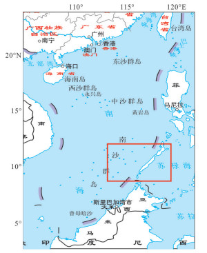
图 1 研究海域地理位置
地图取自自然资源部网站《中国地图 1:4 200万32开》,审图号:GS(2016)1545号
Fig. 1. Geographical location of the study area

图 13 经验模型与OSCAR海流u相对误差
Fig. 13. u relative error of sea flow between empirical model and OSCAR
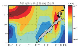
图 14 经验模型与OSCAR海流v相对误差
Fig. 14. v relative error of sea flow between empirical model and OSCAR
表 1 高程计数据融合
Table 1. Altimeter data fusion
Jason⁃2 Value1 Value1 Nan Nan HY⁃2 Value2 Nan Value2 Nan 融合处理 加权平均 Value1 Value2 Nan  下载: 导出CSV
表 2 散射计数据融合
Table 2. Scatterometer data fusion
ASCAT Value1 Value1 Nan Nan HY⁃2 Value2 Nan Value2 Nan 融合处理 加权平均 Value1 Value2 Nan
下载: 导出CSV
-
Chen, Y.D., Zhang, R., Jiang, G.R., 2006. Evaluation and Analysis of Mid-Depth Currents of the Equatorial Pacific Using ARGO Float Position Information. Marine Forecasts, 3(4):37-46 (in Chinese with English abstract). http://en.cnki.com.cn/Article_en/CJFDTOTAL-HYYB200604005.htm Ding, R.R., Zuo, J.C., Du, L., et al., 2007. Sea Level Change in the South China Sea and Its Relations to the Steric Height Variation and Wind. Periodical of Ocean University of China, 37(S2):23-30 (in Chinese with English abstract). http://search.cnki.net/down/default.aspx?filename=QDHY2007S2005&dbcode=CJFD&year=2007&dflag=pdfdown Ekman, V.W., 1905. On the Influence of the Earth's Rotation on Ocean Currents. Arch. Math. Astron. Phys, 2:1-52. El-Nabulsi, R. A., 2019. Geostrophic Flow and Wind-Driven Ocean Currents Depending on the Spatial Dimensionality of the Medium. Pure and Applied Geophysics, 176(6):2739-2750. https://doi.org/10.1007/s00024-018-2080-x Guo, Z.Z., Yin, K.L., Fu, S., et al., 2019. Evaluation of Landslide Susceptibility Based on GIS and WOE-BP Model. Earth Science, 44(12):4299-4312 (in Chinese with English abstract). http://www.researchgate.net/publication/324390254_Evaluation_of_Landslide_Susceptibility_Based_on_GIS_and_WOE-BP_Model He, J.L., Cai, S.Q., 2012. Study on the Hydrological Characteristic Parameters and Flow Field East of the Luzon Strait Using ARGO Profiling Floats. Journal of Tropical Oceanography, 31(1):18-27 (in Chinese with English abstract). http://en.cnki.com.cn/Article_en/CJFDTOTAL-RDHY201201004.htm Jiang, Z.H., Huang, S.X., Liu, G., et al., 2011. Research on the Development of Surface Wind Speed Retrieval from Satellite Radar Altimeter. Marine Science Bulletin, 30(5):88-594 (in Chinese with English abstract). http://en.cnki.com.cn/Article_en/ http://search.cnki.net/down/default.aspx?filename=HUTB201105020&dbcode=CJFD&year=2011&dflag=pdfdown Johnson, E. S., Bonjean, F., Lagerloef, G. S. E., et al., 2007. Validation and Error Analysis of OSCAR Sea Surface Currents. Journal of Atmospheric and Oceanic Technology, 24(4):688-701. https://doi.org/10.1175/jtech1971.1 Lagerloef, G. S. E., Mitchum, G. T., Lukas, R. B., et al., 1999. Tropical Pacific Near-Surface Currents Estimated from Altimeter, Wind, and Drifter Data. Journal of Geophysical Research:Oceans, 104(C10):23313-23326. https://doi.org/10.1029/1999jc900197 Lan, Y.G., Lang, S.Y., Lin, M.S., et al., 2018. Application of Microwave Scatter Meter Onboard HY-2A Satellite in Typhoon Remote Sensing Monitoring. Satellite Application, (5):40-42 (in Chinese with English abstract). Li, L., Gai, Y.H., Ouyang, M., et al., 2019. Technologies with Two Azimuths in West Area of South China Sea:A Case Study of Zhusan Sag. Earth Science, 44(8):2590-2596 (in Chinese with English abstract). Liu, W., Zhang, R., Wang, H.Z., et al., 2012. Sea Surface Flow Field Retrieval and Estimation Based on Satellite Remote Sensing Data. Progress in Geophysics, 27(5):1989-1994 (in Chinese). http://en.cnki.com.cn/Article_en/CJFDTOTAL-DQWJ201205019.htm Lukas, R., Firing, E., 1984. The Geostrophic Balance of the Pacific Equatorial Undercurrent. Deep Sea Research Part A Oceanographic Research Papers, 31(1):61-66. https://doi.org/10.1016/0198-0149(84)90072-4 Mao, Q.W., Shi, P., Qi, Y.Q., 1999. Sea Surface Dynamic Topography and Geostrophic Current over the South China Sea from Geosat Altimeter Observation. Acta Oceanologica Sinica, 21(1):11-16 (in Chinese with English abstract). http://ci.nii.ac.jp/naid/10025551999 Pedlosky, J., 2013. An Inertial Model of the Interaction of Ekman Layers and Planetary Islands. Journal of Physical Oceanography, 43(7):1398-1406. https://doi.org/10.1175/jpo-d-13-028.1 Picaut, J., Hayes, S. P., McPhaden, M. J., 1989. Use of the Geostrophic Approximation to Estimate Time-Varying Zonal Currents at the Equator. Journal of Geophysical Research, 94(C3):3228. https://doi.org/10.1029/jc094ic03p03228 Shrira, V. I., Almelah, R. B., 2019. Upper-Ocean Ekman Current Dynamics:A New Perspective. Journal of Fluid Mechanics, 887:1-23. https://doi.org/10.1017/jfm.2019.1059 Song, X.X., Wang, J., Chu, X.Q., et al., 2019. Estimation of Sea Surface Velocities from SAR Images Using the Doppler Shift. Remote Sensing Technology and Application, 34(2):293-302 (in Chinese with English abstract). http://en.cnki.com.cn/Article_en/CJFDTotal-YGJS201902009.htm van Meurs, P., Niiler, P. P., 1997. Temporal Variability of the Large-Scale Geostrophic Surface Velocity in the Northeast Pacific. Journal of Physical Oceanography, 27(10):2288-2297. https://doi.org/10.1175/1520-0485(1997)027 < 2288:tvotls>2.0.co; 2 doi: 10.1175/1520-0485(1997)027<2288:tvotls>2.0.co;2 Wang, D.L., Yao, X.H., Meng, L., et al., 2014. Validation and Analysis of Wind Field Products of HY-2. Marine Forecasts, 31(4):47-53 (in Chinese with English abstract). http://en.cnki.com.cn/Article_en/CJFDTOTAL-HYYB201404007.htm Wang, H.P., Wang, C.M., Xiang, J., et al., 2014. Validation of Quik SCAT Satellite Scatterometer Winds and Characteristics of Monthly Mean Wind Speed in South China Sea. Journal of the Meteorological Sciences, 34(1):54-59 (in Chinese with English abstract). http://en.cnki.com.cn/Article_en/CJFDTOTAL-QXKX201401008.htm Wang, J.H., Yu, H., Miao, C.S., et al., 2016. Analysis and Simulation of the Wind Fields Impact on Sea Level Features of Yellow Sea and East China Sea. Transactions of Atmospheric Sciences, 39(1):90-101 (in Chinese with English abstract). http://en.cnki.com.cn/Article_en/CJFDTOTAL-NJQX201601011.htm Wang, W.C., Wen, H.J., Liu, H.L., et al., 2019. The Determination Method of High Precision Geostrophic Currents in East China Sea. Science of Surveying and Mapping, 44(8):37-43 (in Chinese with English abstract). http://en.cnki.com.cn/Article_en/CJFDTotal-CHKD201908006.htm Zhang, G. S., Perrie, W., Zhang, B., et al., 2020. Monitoring of Tropical Cyclone Structures in Ten Years of RADARSAT-2 SAR Images. Remote Sensing of Environment, 236:111449. https://doi.org/10.1016/j.rse.2019.111449 Zheng, G.Z., Le, X.D., Wang, H.P., et al., 2017. Inversion of Water Depth from WorldView-02 Satellite Imagery Based on BP and RBF Neural Network. Earth Science, 42(12):2345-2353 (in Chinese with English abstract). http://en.cnki.com.cn/Article_en/CJFDTOTAL-DQKX201712018.htm 陈奕德, 张初, 蒋国荣, 2006.利用ARGO浮标定位信息估算分析赤道太平洋中层流场状况.海洋预报, 23(4):37-46. doi: 10.3969/j.issn.1003-0239.2006.04.005 丁荣荣, 左军成, 杜凌, 等, 2007.南海海平面变化及其比容高度和风场间的关系.中国海洋大学学报, 37(S2):23-30. https://www.cnki.com.cn/Article/CJFDTOTAL-QDHY2007S2005.htm 郭子正, 殷坤龙, 付圣, 等, 2019.基于GIS与WOE-BP模型的滑坡易发性评价.地球科学, 44(12):4299-4312. doi: 10.3799/dqkx.2016.032 何建玲, 蔡树群, 2012.利用ARGO数据计算吕宋海峡以东海域水文特性参数和流场.热带海洋学报, 31(1):18-27. https://www.cnki.com.cn/Article/CJFDTOTAL-RDHY201201004.htm 姜祝辉, 黄思训, 刘刚, 等, 2011.星载雷达高度计反演海面风速进展.海洋通报, 30(5):588-594. doi: 10.3969/j.issn.1001-6392.2011.05.019 李列, 盖永浩, 欧阳敏, 等, 2019.南海西部双方位地震资料处理关键技术实践:以珠三凹陷为例.地球科学, 44(8):2590-2596. doi: 10.3799/dqkx.2019.140 兰友国, 郎姝燕, 林明森, 等, 2018.海洋二号卫星A星微波散射计在台风遥感监测中的应用.卫星应用, (5):40-42. doi: 10.3969/j.issn.1674-9030.2018.05.011 刘巍, 张韧, 王辉赞, 等, 2012.基于卫星遥感资料的海洋表层流场反演与估算.地球物理学进展, 27(5):1989-1994. https://www.cnki.com.cn/Article/CJFDTOTAL-DQWJ201205019.htm 毛庆文, 施平, 1999.GEOSAT卫星遥感资料研究南海海面动力髙度场和地转流场.海洋学报, 21(1):11-16. doi: 10.3321/j.issn:0253-4193.1999.01.002 宋晓霞, 王静, 储小青, 等, 2019.基于多普勒频移的SAR海表流场反演.遥感技术与应用, 34(2):293-302. https://www.cnki.com.cn/Article/CJFDTOTAL-YGJS201902009.htm 王东良, 姚小海, 孟雷, 等, 2014.海洋二号卫星散射计风场产品真实性检验及分析.海洋预报, 31(4):47-53. https://www.cnki.com.cn/Article/CJFDTOTAL-HYYB201404007.htm 王坚红, 于华, 苗春生, 等, 2016.近海面风场对黄东海域海平面特征影响的分析与模拟.大气科学学报, 39(1):90-101. https://www.cnki.com.cn/Article/CJFDTOTAL-NJQX201601011.htm 王文超, 文汉江, 刘焕玲, 等, 2019.我国东部海域高精度地转流的确定方法.测绘科学, 44(8):37-43. https://www.cnki.com.cn/Article/CJFDTOTAL-CHKD201908006.htm 王慧鹏, 王春明, 项杰, 等, 2014.QuikSCAT卫星散射计矢量风检验及南海月平均风场特征分析.气象科学, 34(1):54-59. https://www.cnki.com.cn/Article/CJFDTOTAL-QXKX201401008.htm 郑贵洲, 乐校东, 王红平, 等, 2017.基于WorliView-02高分影像的BP和RBF神经网络遥感水深反演.地球科学, 42(12):2345-2353. doi: 10.3799/dqkx.2017.552 -


 下载:
下载:


 点击查看大图
计量
- 文章访问数: 2608
- HTML全文浏览量: 906
- PDF下载量: 120
- 被引次数: 0
