


Thoughts, Principles and Methods of Regional Geological Survey in Covered Area (1:50 000)
-
摘要: 随着生态文明建设成为新时期国家目标,区域地质调查必须为我国能源资源安全保障和国土空间规划与生态文明建设服务.目前,我国区域地质调查工作已经向覆盖区为主的平原、盆地、草原、荒漠等地区拓展,但现行的地质填图技术方法体系,难以满足现今覆盖区地质填图工作的需要,亟待探索形成新的地质填图技术方法体系,扩大地质调查成果的服务领域.中国地质调查局于2014年设立了“特殊地质地貌区填图试点”项目,探索总结覆盖区区域地质填图技术方法.经过努力,形成了以“覆盖区区域地质调查技术要求(1:50 000)”为核心的覆盖区填图技术方法体系.试点项目初步确立了中国东部晚新生代以来构造-沉积演化的基本格架,揭示了晚更新世以来中国中东部沉积过程与生态环境演化及人类文明发展的制约关系.该方法体系的建立,对引领我国区域地质调查服务国家生态文明建设和生态环境保护具有重要意义.新的填图方法体系明确提出聚焦国家生态文明建设与生态环境保护,以地球系统科学为覆盖区区域地质调查的理论基础,实行需求驱动、问题导向、目标考核,努力解决调查区重大基础地质问题、重大资源与生态环境问题.调查的技术路线是地表地质调查与多种现代地球探测技术、信息技术等高度融合,并强调预研究与设计阶段的重要性.同时规定不平均使用工作量,取消填图主要实物工作量的量化指标规定;创新成果表达方式,明确地质填图服务多种社会需求,倡导填图首席科学家负责制,建立区调填图诚信体系.Abstract: As the construction of ecological civilization has become the national goal,the regional geological survey must serve the security of energy and resources,the planning of land space,and the construction of ecological civilization. Presently,the regional geological survey has expanded to covered areas in China,such as plain,basin,grassland,desert,and so on. However,the current geological mapping technology and method system cannot meet the needs of the current work. It is urgent to explore new patterns and mapping technology and method systems and expand the service field of achievement. In 2014, China Geological Survey set up the "special geological and geomorphic area mapping pilot project",which explored and summarized the technology and method system of regional geological mapping in the covered area. Now,the mapping technology and method system of covered area with "technical method guide for regional geological survey in covered area (1:50 000)" as the core has formed. The framework of tectonic sedimentary evolution in eastern China since the Late Cenozoic has been preliminarily established,which reveals the constraints of the sedimentary process,the ecological environment evolution and the development of human civilization in eastern China since the Late Pleistocene. This technological system will be significant to lead the regional geological survey in the covered area,serve the national ecological civilization construction and ecological environment protection. The new mapping method system clearly puts forward to focus on national ecological civilization construction and ecological environment protection,take the earth system science as the theoretical basis of regional geological survey in the covered area,implement demand driven,problem-oriented and target assessment,and strive to solve the major basic geological issues,major resources and ecological environment issues in the survey area. The technical route is high integration of surface geological survey with various modern detection technologies and information technologies,and the importance of pre-research and design stage is emphasized. At the same time,it is necessary to stipulate the uneven workload,cancel the quantitative indicators of the main mapping work,innovate the expression of achievements,make clear that geological mapping serves a variety of social needs,advocate the chief mapping scientist responsibility system,and establish a regional survey mapping integrity system.
-

图 1 中国陆域主要地质地貌区分布
中国地图引自中国主要河流、湖泊图(比例尺为1:1 600万,审图号:GS(2019)4345号),源自自然资源部的标准地图服务系统(http://bzdt.ch.mnr.gov.cn).平原区:a.三江平原;b.华北平原;c.长江中下游平原;d.珠江三角洲平原;e.成都平原;f.关中平原(汾渭平原);g.河套平原;h.准噶尔平原;i.吐鲁番平原.沙漠区:1.塔克拉玛干沙漠,2.古尔班通古特沙漠;3.库姆塔格沙漠;4.柴达木盆地沙漠;5.巴丹吉林沙漠;6.腾格里沙漠;7.乌兰布和沙漠;8.库布齐沙漠;9.毛乌素沙漠;10.浑善达克沙地;11.科尔沁沙地;12.呼伦贝尔沙地
Fig. 1. Distribution of main geological and geomorphic areas in the land territory of China
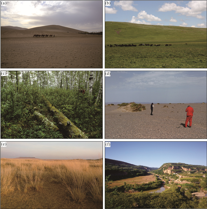
图 2 不同类型地质地貌区的地貌特征
a.戈壁荒漠区(甘肃敦煌地区);b.西部湿地(四川诺尔盖湿地);c.森林沼泽区(黑龙江大兴安岭地区);d.戈壁荒漠区(新疆巴里坤地区);e.草原荒漠区(内蒙古温牛特地区);f.黄土覆盖区(陕西千阳)
Fig. 2. Geomorphic characteristics of different types of geological and geomorphic areas

图 3 覆盖区区域地质调查工作阶段划分
Fig. 3. Mapping stage division of regional geological survey in covered area

图 4 覆盖区地质填图常用测年方法的测年区间
Fig. 4. Interval of frequently-used dating methods in geological mapping of covered area

图 5 典型地貌区域沉积环境(据Jones,2015)
Fig. 5. Sedimentary environment of typical geomorphic areas (modified after Jones, 2015)
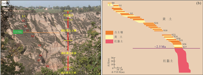
图 6 典型黄土沉积剖面
a.甘肃庆阳地区黄土剖面(李朝柱提供),b.黄土高原晚新生代黄土-古土壤-红黏土序列(据李徐生(2011)修改,内部课件)
Fig. 6. Typical sedimentary profile of loess
图 7 安徽宣城地区第四纪红土剖面(据Hong et al., 2010)
Fig. 7. Sedimentary profile of Quaternary laterite in Xuancheng area, Anhui Province (modified after Hong et al., 2010)
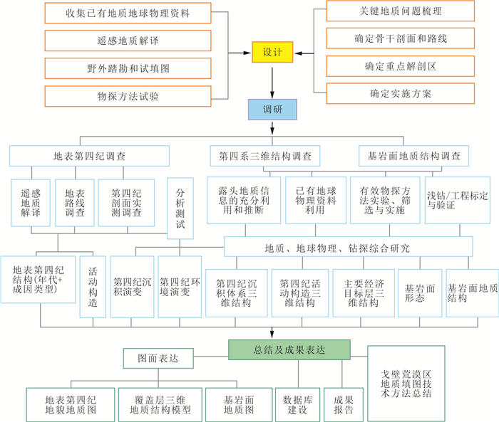
图 8 戈壁荒漠区填图技术路线图(据王国灿等,2018)
Fig. 8. Technology route of geological mapping in Gobi desert area (modified after Wang et al., 2018)
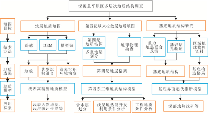
图 9 长三角平原区填图技术路线图(据李向前等,2018)
Fig. 9. Technology route of geological mapping in Yangtze River delta plain area (modified after Li et al., 2018)
-
Bu, J.J., Wu, J., Deng, F., et al., 2020.A Guide to the 1: 50 000 Mapping Methods in Strongly Weathered Layer Covered Area in South China.In: Hu, J. M., ed., Collection of Guides to Mapping Methods in Special Geological and Geomorphological Areas.Science Press, Beijing(in Chinese). Chen, H., Yang, X., Tian, S.P., et al., 2021.Technical Innovation and Practice of Intelligent Geological Mapping in Coverage Area-A Case Study in Forest-Swamp Area.Geological Bulletin of China(in press) (in Chinese with English abstract). Chen, J.Q., Wang, X.L., Zhang, H.J., et al., 2018.Historical Geology.Geological Press, Beijing(in Chinese). Chen, K.Q., 1995.Chinese Regional Geological Survey Facing the 21st Century.Regional Geology of China, 1:1-5(in Chinese with English abstract). Cheng, G.H., Zhai, G.Y., Zhuang, Y.X., et al., 2013.A Guide to Urban Geological Survey in China.Science Press, Beijing(in Chinese). Dong, S.W., Gao, R., Yin, A., et al., 2013.What Drove Continued Continent-Continent Convergence after Ocean Closure? Insights from High-Resolution Seismic-Reflection Profiling across the Daba Shan in Central China.Geology, 41(6):671-674. https://doi.org/10.1130/g34161.1 Dong, S.W., Li, T.D., Chen, X.H., et al., 2014.Sino-Probe Revealed Crustal Structures, Deep Processes, and Metallogenic Background within China Continent.Earth Science Frontiers, 21(3):201-225(in Chinese with English abstract). http://en.cnki.com.cn/Article_en/CJFDTOTAL-DXQY201403030.htm Du, Z.T., Mao, X.C., 2017.A Study of the Standard System of Regional Geological Survey.Geological Bulletin of China, 36(10):1823-1829(in Chinese with English abstract). Du, Z.T., Zhai, G.Y., Cheng, G.H., 2014.Strategy Study of Chinese Basic Geological Survey.Geological Press, Beijing(in Chinese). Fang, L.M., 1991.A Guide to the Method of the 1:50 000 Regional Geological Survey in Metamorphic Rock Areas. China University of Geosciences Press, Wuhan (in Chinese). Gao, B.Z., Hong, D.W., Zheng, J.J., et al., 1991.A Guide to the Method of the 1:50 000 Regional Geological Survey in Granite Rock Areas.China University of Geosciences Press, Wuhan(in Chinese). Gu, P.Y., Chen, R.M., Hu, J.M., et al., 2018.A Guide to the 1: 50 000 Mapping Methods in Alpine Valley Area.In: Hu, J.M., ed., Collection of Guides to Mapping Methods in Special Geological and Geomorphological Areas.Science Press, Beijing(in Chinese). Hong, H.L., Gu, Y.S., Li, R.B., et al., 2010.Clay Mineralogy and Geochemistry and Their Palaeoclimatic Interpretation of the Pleistocene Deposits in the Xuancheng Section, Southern China.Journal of Quaternary Science, 25(5):662-674. https://doi.org/10.1002/jqs.1340 Hou, Z.Q., 2018.Based on Earth System Science, Supporting the Unified Management and System Restoration of Natural Resources.China Natural Resources, 5:6-12(in Chinese with English abstract). http://www.researchgate.net/publication/332298401_SUBMISSION_OF_ADMINISTRATIVE_DECISIONS_OF_USING_RECREATION_AND_TOURIST_TERRITORY_AND_DEVELOPMENT_OF_ALTERNATIVE_ACTIVITY_TYPES Hu, D.G., Liu, F.S., Wu, Z.H., et al., 2013.Geological Mapping Methods in Europe and America:Experiences, Pilots and Suggestions-Taking the Geological Mapping Test of the East Kunlun Orogenic Belt as an Example.Geological Press, Beijing(in Chinese). Hu, J.M., 2016.General Situations of Geology Land Mapping in Special Areas.Journal of Geomechanics, 22(4):803-808(in Chinese with English abstract). Hu, J.M., Chen, H., Liang, X., et al., 2017.Technique Methods and Applications of Geology Land Mapping in Special Areas.Journal of Geomechanics, 23(2):181(in Chinese with English abstract). Jiang, Z.Q., 2008.Present Status and Features of Informationization of the Full Process of Regional Geological Survey at Home and Abroad.Geological Bulletin of China, 27(7):956-964(in Chinese with English abstract). http://www.researchgate.net/publication/287551439_Present_status_and_features_of_informationization_of_the_full_process_of_regional_geological_survey_at_home_and_abroad Jones, S., 2015.Introducing Sedimentology.Dunedin Academic Press, Edinburgh. Li, C.Z., Fu, J.L., Wang, S.B., et al., 2020.A Guide to the 1: 50 000 Mapping Methods in Loess Covered Area.In: Hu, J.M., ed., Collection of Guides to Mapping Methods in Special Geological and Geomorphological Areas.Science Press, Beijing(in Chinese). Li, J.F., 2019.Focus on Demand, Consolidate the Foundation, and Comprehensively Promote the Reform and Development of Regional Geological Survey Work:Report at the Third National Regional Geological Survey Work Conference.Bulletin of China Geological Survey, the Ministry of Natural Resources, 29:1-21(in Chinese). Li, X.Q., Zhao, Z.Y., Cheng, Y., et al., 2016.Multi-Level Geological Mapping Approaches of the Plane Area and Applications:A Case Study in 1:50 000 Sheets of Gangkou, Taixian, Zhangdiangongshe, Taixingxian and Shengcitang.Journal of Geomechanics, 22(4):822-836(in Chinese with English abstract). http://en.cnki.com.cn/Article_en/CJFDTotal-DZLX201604003.htm Li, X.Q., Zhao, Z.Y., Qiu, S.D., et al., 2018.A Guide to the 1: 50 000 Mapping Methods in Yangtze River Delta Plain.In: Hu, J.M., eds., Collection of Guides to Mapping Methods in Special Geological and Geomorphological Areas.Science Press, Beijing(in Chinese). Li, Z.H., Chen, H., Shi, W., et al., 2020.A Guide to the 1: 50 000 Mapping Methods in Active Structure Development Areas.In: Hu, J.M., eds., Collection of Guides to Mapping Methods in Special Geological and Geomorphological Areas.Science Press, Beijing(in Chinese). Liao, C.G., Yang, W.N., Pu, G.L., et al., 2003.Application of Different Fusion Method to Regional Geological Surveying.Journal of Chengdu University of Technology(Science & Technology Edition), 30(3):294-298(in Chinese with English abstract). http://en.cnki.com.cn/Article_en/CJFDTOTAL-CDLG200303013.htm Lin, A.M., Rao, G., Yan, B., 2015.Flexural Fold Structures and Active Faults in the Northern-Western Weihe Graben, Central China.Journal of Asian Earth Sciences, 114:226-241. https://doi.org/10.1016/j.jseaes.2015.04.012 Liu, F.S., Zhuang, Y.X., 2001.Summary of National Regional Geological Survey in 1999-2000.Regional Geology of China, 20(3):225-228(in Chinese with English abstract). Liu, S.Y., 2016.The Third Pillar of Geophysical Technology.Geological Press, Beijing(in Chinese). Lü, Y., Pan, M., Shan, K.Q., et al., 2020. A Guide to the 1: 50 000 Mapping Methods in Karst Area.In: Hu, J. M., ed., Collection of Guides to Mapping Methods in Special Geological and Geomorphological Areas. Science Press, Beijing(in Chinese). Ma, J.Q., Li, J.T., Feng, Z.Z., 2000.On Volcano-Tectonic Associations and Their Geological Mapping:An Example from 1:50 000 Regional Geological Surveying in Mingqing Area, Fujian.Regional Geology of China, 19(2):198-204(in Chinese with English abstract). http://en.cnki.com.cn/Article_en/CJFDTOTAL-ZQYD200002015.htm Mao, X.C., 2006.The Report Meeting on the Results of Regional Geological Survey of 1:250 000 in the Blank Area of the Qinghai-Tibet Plateau and the Key Seminar of the Eleventh Five-Year Plan were Held in Chengdu.Geology in China, 1:222(in Chinese). Meng, P.Y., Sun, J., Yu, C.C., et al., 2016.Lithological Information Extraction in Mountain Canyon Region Based on Multi-Source Remote Sensing Data:A Case Study of 1:50 000 Pilot Geological Mapping in Beishan Area in Wushi, Xinjinag.Journal of Geomechanics, 22(4):907-920(in Chinese with English abstract). http://en.cnki.com.cn/Article_en/CJFDTotal-DZLX201604009.htm Pan, G.T., Ding, J., Wang, L.Q., et al., 2002.Important New Progress in Regional Geological Survey of the Qinghai-Tibet Plateau.Geological Bulletin of China, 21(11):787-793(in Chinese with English abstract). Sun, K., 2018.Research on Integrated Application of Geophysical Information on Geological Mapping of Barkol Basin(Dissertation).China University of Geosciences, Wuhan(in Chinses with English abstract). Tian, S.P., Wang, D.M., Zhang, T., et al., 2020.A Guide to the 1: 50 000 Mapping Methods in Forest Swamp Shallow Covered Area.In: Hu, J.M., ed., Collection of Guides to Mapping Methods in Special Geological and Geomorphological Areas.Science Press, Beijing(in Chinese). Wang, G.C., Chen, C., Hu, J.M., et al., 2018.A Guide to the 1: 50 000 Mapping Methods in Gobi Desert Covered Area.In: Hu, J.M., ed., Collection of Guides to Mapping Methods in Special Geological and Geomorphological Areas.Science Press, Beijing(in Chinese). Wang, P.X., Tian, J., Huang, E.Q., et al., 2018.Earth System and Evolution.Science Press, Beijing(in Chinese). Wei, J.Y., Lu, C.M., Xu, H.A., et al., 1991.A Guide to the Method of the 1:50 000 Regional Geological Survey in Sedimentary Rock Areas.China University of Geoscience Press, Wuhan (in Chinese). Wei, Z.X., Yan, X.X., Zhai, G.Y., 2010.Urban Geology in Shanghai.Geological Press, Beijing (in Chinese). Wu, J., Bu, J.J., Xie, G.G., et al., 2016.Application of Regional Geochemical Data in Geological Mapping in Strongly Weathered Area in Southern China.Journal of Geomechanics, 22(4):955-966(in Chinese with English abstract). http://en.cnki.com.cn/Article_en/CJFDTOTAL-DZLX201604013.htm Xu, Q., 2002.Marjor Progress in the Digital Acquisition System of Regional Geological Investigation of China.Geological Review, 48(2):167(in Chinese with English abstract). Yao, T.D., Liu, Y.Q., Chen, F.H., et al., 2018.Earth System Science: Progress and Prospect.In: Chinese Academy of Sciences, ed., Science Development Report in 2018.Science Press, Beijing, 32-52(in Chinese). Yeats, R.S., Seih, K., Allen, C.R., 1997.The Geology of Earthquakes.Oxford University Press, Oxford, 568. Yin, Y.G., Shi, W., Gong, W.B., et al., 2017.The Application of Ground Penetrating Radar Technology in Geological Mapping of Shallow Covered Active Tectonic Region:A Case Study of 1:50 000 Mapping of Neotectonic Zone and Active Tectonic Zone in Qingtongxia Area, Ningxia.Journal of Geomechanics, 23(2):214-223(in Chinese with English abstract). http://en.cnki.com.cn/Article_en/CJFDTOTAL-DZLX201702005.htm Yu, J.J., Wang, G.C., Xu, Y.X., et al., 2015.Constraining Deep Geological Structures in Three-Dimensional Geological Mapping of Complicated Orogenic Belts:A Case Study from Karamay Region, Western Junggar.Earth Science, 40(3):407-418, 424(in Chinese with English abstract). http://www.researchgate.net/publication/282723615_Constraining_deep_geological_structures_in_three-dimensional_geological_mapping_of_complicated_orogenic_belts_a_case_study_from_Karamay_Region_Western_Junggar Yu, J.S., Jing, L., Wang, Q.L., et al., 2016.Application of Geophysical and Geochemical Prospecting Techniques in Special Geological and Geomorphic Areas.Journal of Geomechanics, 22(4):893-906(in Chinese with English abstract). http://en.cnki.com.cn/Article_en/CJFDTotal-DZLX201604008.htm Zhang, G.Y., Fu, J.Y., Ouyang, Z.Z., et al., 2020.The Importance of Space Database Establishment Based on DGSS in Big Data Environment.Earth Science, 45(9):3451-3460(in Chinese with English abstract). Zhang, K.X., Li, C.L., Yu, Q.W., et al., 2007.The Digital Section System of Digital Mapping Techniques.Journal of Stratigraphy, 31(2):157-164(in Chinses with English abstract). doi: 10.1117/12.759678 Zhang, Y.Q., Zhuan, S.P., Wei, W.T., et al., 2020.A Guide to the 1: 50 000 Mapping Methods in Beijing-Tianjin-Hebei Piedmont Alluvial Plain.In: Hu, J.M., ed., Collection of Guides to Mapping Methods in Special Geological and Geomorphological Areas.Science Press, Beijing (in Chinese). 卜建军, 吴俊, 邓飞, 等, 2020.中国南方强风化层覆盖区1: 50 000填图方法指南.见: 胡健民主编, 特殊地质地貌区填图方法指南丛书.北京: 科学出版社. 陈虹, 杨晓, 田世攀, 等, 2021.覆盖区智能地质填图的探索与实践——以森林沼泽区为例.地质通报(待刊). 陈建强, 王训练, 张海军, 等, 2018.地史学简明教程.北京:地质出版社. 陈克强, 1995.面向21世纪的中国区域地质调查工作.中国区域地质, 1:1-5. https://www.cnki.com.cn/Article/CJFDTOTAL-ZQYD501.000.htm 程光华, 翟刚毅, 庄育勋, 等, 2013.中国城市地质调查技术方法.北京:科学出版社. 董树文, 李廷栋, 陈宣华, 等, 2014.深部探测揭示中国地壳结构、深部过程与成矿作用背景.地学前缘, 21(3):201-225. https://www.cnki.com.cn/Article/CJFDTOTAL-DXQY201403030.htm 杜子图, 毛晓长, 2017.区域地质调查标准体系研究.地质通报, 36(10):1823-1829. doi: 10.3969/j.issn.1671-2552.2017.10.013 杜子图, 翟刚毅, 程光华, 2014.中国基础地质调查发展战略研究.北京:地质出版社. 房立民, 1991.变质岩区1:5万区域地质填图方法指南.武汉:中国地质大学出版社. 高秉章, 洪大卫, 郑基俭, 等.花岗岩类区1:5万区域地质填图方法指南.武汉:中国地质大学出版社, 1991. 辜平阳, 陈锐明, 胡健民, 等, 2018.高山峡谷区1: 50 000填图方法指南.见: 胡健民主编, 特殊地质地貌区填图方法指南丛书.北京: 科学出版社. 侯增谦, 2018.立足地球系统科学, 支撑自然资源统一管理和系统修复.中国自然资源报, 5:6-12. https://xuewen.cnki.net/CCND-GTZY201806120050.html 胡道功, 刘凤山, 吴珍汉, 等, 2013.欧美地质填图方法:经验、试点与建议——以东昆仑造山带地质填图试验为例.北京:地质出版社. 胡健民, 2016.特殊地区地质填图工程概况.地质力学学报, 22(4):803-808. doi: 10.3969/j.issn.1006-6616.2016.04.001 胡健民, 陈虹, 梁霞, 等, 2017.特殊地区地质填图技术方法及应用成果.地质力学学报, 23(2):181. https://www.cnki.com.cn/Article/CJFDTOTAL-DZLX201702001.htm 姜作勤, 2008.国内外区域地质调查全过程信息化的现状与特点.地质通报, 27(7):956-964. doi: 10.3969/j.issn.1671-2552.2008.07.004 李朝柱, 傅建利, 王书兵, 等, 2020.黄土覆盖区1: 50 000填图方法指南.见: 胡健民主编, 特殊地质地貌区填图方法指南丛书.北京: 科学出版社. 李金发, 2019.聚焦需求, 夯实基础, 全面推进区域地质调查工作改革发展——在第三次全国区域地质调查工作会议上的报告.自然资源部中国地质调查局情况通报, 29:1-21. https://www.cnki.com.cn/Article/CJFDTOTAL-QYWA201111116.htm 李向前, 赵增玉, 程瑜, 等, 2016.平原区多层次地质填图方法及成果应用——以江苏港口、泰县、张甸公社、泰兴县、生祠堂镇幅平原区1:50 000填图试点为例.地质力学学报, 22(4):822-836. doi: 10.3969/j.issn.1006-6616.2016.04.003 李向前, 赵增玉, 邱士东, 等, 2018.长三角平原区1: 50 000填图方法指南.见: 胡健民主编, 特殊地质地貌区填图方法指南丛书.北京: 科学出版社. 李振宏, 陈虹, 施炜, 等, 2020.活动构造发育区1: 50 000填图方法指南.见: 胡健民主编, 特殊地质地貌区填图方法指南丛书.北京: 科学出版社. 廖崇高, 杨武年, 濮国梁, 等, 2003.不同融合方法在区域地质调查中的应用.成都理工大学学报(自然科学版), 30(3):294-298. doi: 10.3969/j.issn.1671-9727.2003.03.013 刘凤山, 庄育勋, 2001.1999-2000年度全国区域地质调查总结.中国区域地质, 20(3):225-228. doi: 10.3969/j.issn.1671-2552.2001.03.001 刘士毅, 2016.物探技术的第三根支柱.北京:地质出版社. 吕勇, 潘明, 山克强, 等, 2020.岩溶区1: 50 000填图方法指南.胡健民主编: 特殊地质地貌区填图方法指南丛书.北京: 科学出版社. 马金清, 李进堂, 冯宗帜, 2000.火山构造组合研究和地质填图方法——以福建闽清测区1:5万区域地质调查为例.中国区域地质, 19(2):198-204. doi: 10.3969/j.issn.1671-2552.2000.02.016 毛晓长, 2006.青藏高原空白区1:25万区域地质调查成果报告会暨"十一五"工作重点研讨会在成都召开.中国地质, 1:222. https://www.cnki.com.cn/Article/CJFDTOTAL-DIZI200601025.htm 孟鹏燕, 孙杰, 于长春, 等, 2016.基于多源遥感数据的高山峡谷区岩性信息提取研究——以新疆乌什县北山1:50 000填图试点为例.地质力学学报, 22(4):907-920. doi: 10.3969/j.issn.1006-6616.2016.04.009 潘桂棠, 丁俊, 王立全, 等, 2002.青藏高原区域地质调查重要新进展.地质通报, 21(11):787-793. doi: 10.3969/j.issn.1671-2552.2002.11.018 孙凯, 2018.巴里坤盆地地质填图中地球物理信息综合应用研究(硕士学位论文).武汉: 中国地质大学. 田世攀, 王东明, 张昱, 等, 2020.森林沼泽浅覆盖区1: 50 000填图方法指南.见: 胡健民主编, 特殊地质地貌区填图方法指南丛书.北京: 科学出版社. 王国灿, 陈超, 胡健民, 等, 2018.戈壁荒漠覆盖区1: 50 000填图方法指南.见: 胡健民主编, 特殊地质地貌区填图方法指南丛书.北京: 科学出版社. 汪品先, 田军, 黄恩清, 等, 2018.地球系统与演变.北京:科学出版社. 魏家庸, 卢重明, 徐怀艾, 等, 1991.沉积岩区1:5万区域地质填图方法指南.武汉:中国地质大学出版社. 魏子新, 闫学新, 翟刚毅, 2010.上海城市地质.北京:地质出版社. 吴俊, 卜建军, 谢国刚, 等, 2016.区域化探数据在华南强烈风化区地质填图中的应用.地质力学学报, 22(4):955-966. doi: 10.3969/j.issn.1006-6616.2016.04.013 徐强, 2002.我国区域地质调查数字采集系统研究取得重大进展.地质论评, 48(2):167. doi: 10.3321/j.issn:0371-5736.2002.02.016 姚檀栋, 刘永勤, 陈发虎, 等, 2018.地球系统科学发展与展望.见: 中国科学院, 2018科学发展报告.北京: 科学出版社, 32-52. 尹艳广, 施炜, 公王斌, 等, 2017.地质雷达探测技术在浅覆盖活动构造区填图中的应用——以宁夏青铜峡地区1:5万新构造与活动构造区填图为例.地质力学学报, 23(2):214-223. doi: 10.3969/j.issn.1006-6616.2017.02.004 郁军建, 王国灿, 徐义贤, 等, 2015.复杂造山带地区三维地质填图中深部地质结构的约束方法:西准噶尔克拉玛依后山地区三维地质填图实践.地球科学, 40(3):407-418, 424. doi: 10.3799/dqkx.2015.032 喻劲松, 荆磊, 王乔林, 等, 2016.特殊地质地貌区填图物化探技术应用.地质力学学报, 22(4):893-906. doi: 10.3969/j.issn.1006-6616.2016.04.008 张广宇, 付俊彧, 欧阳兆灼, 等, 2020.大数据时代基于DGSS系统下空间数据库建立的重要性.地球科学, 45(9):3451-3460. doi: 10.3799/dqkx.2020.130 张克信, 李超岭, 于庆文, 等, 2007.数字地质填图技术中的数字剖面系统.地层学杂志, 31(2):157-164. https://www.cnki.com.cn/Article/CJFDTOTAL-DCXZ200702008.htm 张运强, 专少鹏, 魏文通, 等, 2020.京津冀山前洪积平原区1: 50 000填图方法指南.见: 胡健民主编, 特殊地质地貌区填图方法指南丛书.北京: 科学出版社. -

 下载:
下载:

 点击查看大图
计量
- 文章访问数: 2417
- HTML全文浏览量: 1196
- PDF下载量: 190
- 被引次数: 0
