


Topographical Linear Feature Extraction Method Based on Sentinel-1 and DEM in Areas with High Vegetation Coverage of Nanling
-
摘要: 在南岭高海拔山脉、植被茂密等地区开展地质调查难度大,人员和物资难以进入,因此需提前根据该区域的地形线性特征合理设计野外调查路线;此外地形线性特征可为区域构造运动信息的认知提供辅助知识.遥感技术以其宏观性、多尺度、多层次的特点成为地质研究和地质勘查的重要手段,然而在高植被覆盖区,常见的光学影像难以穿透植被,而微波雷达遥感则因为较好的植被穿透性,使得其应用成为可能.因此,提出了一种基于雷达卫星Sentinel-1和数字高程模型(digital elevation model,DEM)数据的地形线性特征提取方法.该方法首先利用似然比边缘检测算法提取Sentinel-1影像中的边缘特征,然后对DEM进行线性特征增强以生成山体阴影影像,再利用Canny边缘检测算子提取DEM数据中的山脊线与山谷线等主要线性特征,以DEM提取出的特征线为中心建立缓冲区并与雷达影像的提取结果做相交处理,将得到的线性特征利用道格拉斯-普克算法进行局部直线拟合,最后得到研究区的地形线性特征.结果表明,该方法综合考虑了雷达影像的微观细节信息和DEM数据的宏观趋势信息,在保留主要线性地形特征的同时剔除了伪边缘和噪声点,提取效果较好.Abstract: Geological surveying is challenging in high-altitude mountains with dense vegetation in Nanling because it is inaccessible both for human and material resources. It is necessary to design reasonable field survey routes in advance according to the topographical linear characteristics of the area. Moreover, the topographical linear characteristics can provide the auxiliary information for local tectonic movement. Remotely sensed technology has become an important method for geological research and geological survey due to its macroscopic, multi-scale and multi-level characteristics. However, in areas with high vegetation coverage, optical remote sensing images are difficult to penetrate vegetation, while microwave radar images can do because of its good vegetation penetration. Therefore, the topographical linear feature extraction method based on Sentinel-1 (radar satellite) and DEM data in areas with high vegetation coverage is proposed. This method first uses the likelihood ratio edge detection algorithm to extract the edge features in Sentinel-1 images. Then, the linear features of DEM are enhanced to generate mountain shadow images, and then the main linear features such as ridge lines and valley lines are extracted by Canny edge detection operator. Finally, taking the feature line extracted from DEM as the center, a buffer zone is established and intersected with the result from radar images, and then the local straight line fitting is done by using the Douglas-Puck algorithm to obtain the final topographical linear features in the study area. The results show that the proposed method comprehensively considers the micro-detail information of radar images and the macro-trend information of DEM data, and can remove false edges and noise points while retaining the main topographical linear features, and the extraction effect is good.
-
Key words:
- Sentinel-1 /
- digital elevation model /
- Nanling /
- high vegetation coverage /
- linear feature /
- remote sensing
-
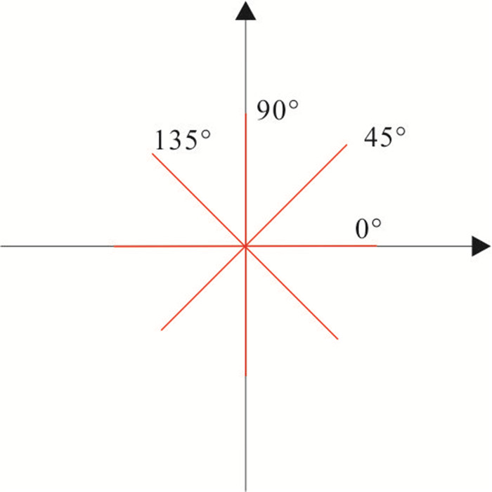
图 2 分方向的滑动窗口(Touzi et al., 1988)
Fig. 2. Sliding windows in different directions (Touzi et al., 1988)
图 4 非极大值抑制窗口(Neubeck and Van Gool,2006)
Fig. 4. Windows for non maximum suppression (Neubeck and Van Gool, 2006)

图 6 基于Sentinel-1和DEM的地形线性特征提取流程
Fig. 6. Flowchart of topographical linear feature extraction based on Sentinel-1 and DEM
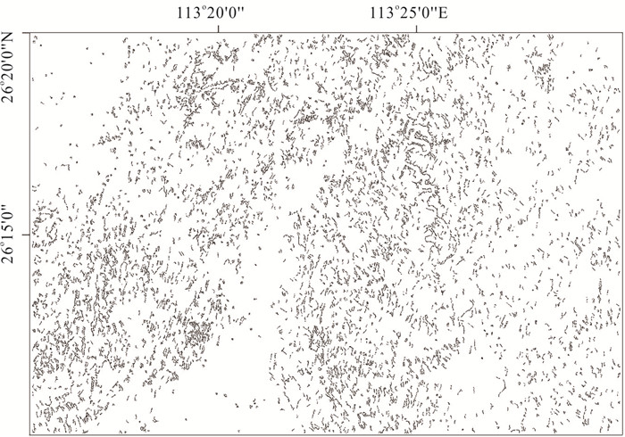
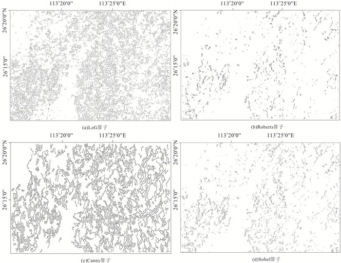
图 7 SAR影像地形线性特征提取结果
Fig. 7. The topographical linear feature extraction result from SAR images
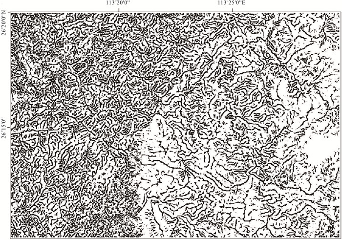
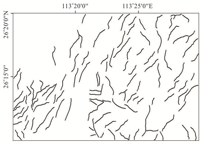
图 9 基于DEM水文分析法提取的地形线性特征
Fig. 9. The topographical linear feature extracted based on DEM hydrological analysis

图 10 基于Sentinel-1和DEM提取的地形线性特征
Fig. 10. The topographical linear feature extracted based on Sentinel-1 and DEM
-
Chen, G.X., Liu, T.Y., Sun, J.S., et al., 2014. Characteristics of Multi-Scale Gravity Field and Deep Structures in Nanling Metallogenic Belt. Earth Science, 39(2): 240-250(in Chinese with English abstract). http://en.cnki.com.cn/Article_en/CJFDTOTAL-DQKX201402012.htm Douglas, D.H., Peucker, T.K., 1973. Algorithms for the Reduction of the Number of Points Required to Represent a Digitized Line or Its Caricature. In: Dodge, M., ed., Classics in Cartography: Reflections on Influential Articles from Cartographica. John Wiley & Sons, Ltd., New York. Gan, C.S., Wang, Y.J., Cai, Y.F., et al., 2016. The Petrogenesis and Tectonic Implication of Wengong Intrusion in the Nanling Range. Earth Science, 41(1): 17-34(in Chinese with English abstract). http://en.cnki.com.cn/Article_en/CJFDTOTAL-DQKX201601002.htm Germain, O., Refregier, P., 2000. On the Bias of the Likelihood Ratio Edge Detector for SAR Images. IEEE Transactions on Geoscience and Remote Sensing, 38(3): 1455-1457. https://doi.org/10.1109/36.843041 Giles, P.T., 1998. Geomorphologic Signatures: Classification of Aggregated Slope Unit Objects from Digital Elevation and Remote Sensing Data. Earth Surface Processes and Landforms, 23(7): 581-594. https://doi.org/10.1002/(sici)1096-9837(199807)23:7<581::aid-esp863>3.0.co;2-s doi: 10.1002/(sici)1096-9837(199807)23:7<581::aid-esp863>3.0.co;2-s Hu, G.B., Liu, F., Dang, W., et al., 2019. Application of Remote Sensing Technology to Geological Mapping in the Vegetation Covered Area of Southwest Yunnan. Remote Sensing for Land & Resources, 31(2): 224-230(in Chinese with English abstract). http://en.cnki.com.cn/Article_en/CJFDTotal-GTYG201902032.htm Hu, J.L., Tang, M.G., Luo, M.L., et al., 2020. The Extraction of Characteristic Elements of Mountain Based on DEM. Journal of Geo-Information Science, 22(3): 422-430 (in Chinese with English abstract). Hu, Q.M., 2017. Research Progress on Extraction Method of Terrain Features Lines. Geomatics & Spatial Information Technology, 40(4): 47-50, 54(in Chinese with English abstract). http://en.cnki.com.cn/Article_en/CJFDTotal-DBCH201704013.htm Lee, T.H., Moon, W.M., 2002. Lineament Extraction from Landsat TM, JERS-1 SAR, and DEM for Geological Applications. IEEE International Geoscience and Remote Sensing Symposium, Toronto, Ontario, Canada, 3276-3278. https://doi.org/10.1109/igarss.2002.1027154 Li, Q., Zhang, J.F., 2019. Investigation on Earthquake-Induced Landslide in Jiuzhaigou Using Fully Polarimetric GF-3 SAR Images. Journal of Remote Sensing, 23(5): 883-891(in Chinese with English abstract). Li, W.K., Zhang, W., Qin, J.H., et al., 2020. "Expansion-Fusion"Extraction of Surface Gully Area Based on DEM and High-Resolution Remote Sensing Images. Earth Science, 45(6): 1948-1955(in Chinese with English abstract). Liu, H., He, Z.W., Zhao, Y.B., et al., 2017. Improved ROEWA Edge Detector for SAR Images. Journal of Remote Sensing, 21(2): 273-279(in Chinese with English abstract). http://en.cnki.com.cn/Article_en/CJFDTOTAL-YGXB201702010.htm Liu, X., Lü, X.B., Wu, C.M., et al., 2020. Topographic Correction Method for High Spatial Resolution Remote Sensing Data in Mountainous Area. Earth Science, 45(2): 645-662 (in Chinese with English abstract). Liu, X.X., Chen, J.P., Zeng, M., et al., 2015. Geological Structural Interpretation of Qiangduo Area in Tibet Based on Multi-Source Remote Sensing Data. Remote Sensing for Land & Resources, 27(3): 154-160(in Chinese with English abstract). http://en.cnki.com.cn/Article_en/CJFDTOTAL-GTYG201503025.htm Masoud, A.A., Koike, K., 2011. Auto-Detection and Integration of Tectonically Significant Lineaments from SRTM DEM and Remotely-Sensed Geophysical Data. ISPRS Journal of Photogrammetry and Remote Sensing, 66(6): 818-832. https://doi.org/10.1016/j.isprsjprs.2011.08.003 Neubeck, A., Van Gool, L., 2006. Efficient Non-Maximum Suppression. 18th International Conference on Pattern Recognition(ICPR'06), Hong Kong, 850-855. https://doi.org/10.1109/icpr.2006.479 Oguchi, T., Aoki, T., Matsuta, N., 2003. Identification of an Active Fault in the Japanese Alps from DEM-Based Hill Shading. Computers & Geosciences, 29(7): 885-891. https://doi.org/10.1016/S0098-3004(03)00083-9 Shu, L.S., Zhou, X.M., Deng, P., et al., 2006. Principal Geological Features of Nanling Tectonic Belt, South China. Geological Review, 52(2): 251-265(in Chinese with English abstract). http://en.cnki.com.cn/Article_en/CJFDTOTAL-DZLP200602017.htm Tan, Q.L., Shao, Y., Fan, X. T, 2002. Geology Application of Radar Remote Sensing Technology and Its Development. Remote Sensing Technology and Application, 17(5): 269-275(in Chinese with English abstract). http://en.cnki.com.cn/Article_en/CJFDTOTAL-DZZK200301012.htm Tang, G.A., Yang, X., 2012. ArcGIS Geographic Information System Spatial Analysis Experiment Tutorial. Science Press, Beijing (in Chinese). Touzi, R., Lopes, A., Bousquet, P., 1988. A Statistical and Geometrical Edge Detector for SAR Images. IEEE Transactions on Geoscience and Remote Sensing, 26(6): 764-773. https://doi.org/10.1109/36.7708 Tu, K., Wen, Q., Chen, H., et al., 2019. New Method of Structural Interpretation in Meadow Covering Based on GaoFen-3 Pol-SAR Images. Journal of Remote Sensing, 23(2): 243-251 (in Chinese with English abstract). http://www.researchgate.net/publication/332706802_New_method_of_structural_interpretation_in_meadow_covering_based_on_GaoFen-3_Pol-SAR_images Wang, R.S., Xiong, S.Q., Nie, H.F., et al., 2011. Remote Sensing Technology and Its Application in Geological Exploration. Acta Geologica Sinica, 85(11): 1699-1743(in Chinese with English abstract). http://en.cnki.com.cn/Article_en/CJFDTOTAL-DZXE201111003.htm Wu, T.D., Lee, M.T., 2007. Geological Lineament and Shoreline Detection in SAR Images.2007 IEEE International Geoscience and Remote Sensing Symposium, Barcelona, 520-523. https://doi.org/10.1109/igarss.2007.4422845 Yan, S.J., Tang, G.A., Li, F.Y., et al., 2011. An Edge Detection Based Method for Extraction of Loess Shoulder-Line from Grid DEM. Geomatics and Information Science of Wuhan University, 36(3): 363-367(in Chinese with English abstract). http://www.cqvip.com/qk/71135x/201107/36919796.html Zhang, H.P., Yang, N., Liu, S.F., et al., 2006. Recent Progress in the DEM-Based Tectonogeomorphic Study. Geological Bulletin of China, 25(6): 660-669(in Chinese with English abstract). http://www.zhangqiaokeyan.com/academic-journal-cn_geological-bulletin-china_thesis/0201252289824.html Zhang, K., Ma, S.B., Li, Z.R., et al., 2016. Geological Interpretation of GF-1 Satellite Imagery. Remote Sensing Information, 31(1): 115-123(in Chinese with English abstract). http://en.cnki.com.cn/Article_en/CJFDTOTAL-YGXX201601019.htm Zhao, L.J., Jia, C.L., Kuang, G.Y., 2007. Overview of Edge Detection in SAR Images. Journal of Image and Graphics, 12(12): 2042-2049(in Chinese with English abstract). http://en.cnki.com.cn/Article_en/CJFDTOTAL-ZGTB200712003.htm Zheng, H.R., Xu, Z.G., Gan, L., et al., 2018. Synthetic Aperture Radar Remote Sensing Technology in Geological Application: A Review. Remote Sensing for Land & Resources, 30(2): 12-20 (in Chinese with English abstract). 陈国雄, 刘天佑, 孙劲松, 等, 2014. 南岭成矿带多尺度重力场及深部构造特征. 地球科学, 39(2): 240-250. doi: 10.3799/dqkx.2014.023 甘成势, 王岳军, 蔡永丰, 等, 2016. 南岭地区温公岩体的岩石成因及其构造指示. 地球科学, 41(1): 17-34. doi: 10.3799/dqkx.2016.002 胡官兵, 刘舫, 党伟, 等, 2019. 遥感技术在滇西南植被覆盖区地质填图中的应用. 国土资源遥感, 31(2): 224-230. https://www.cnki.com.cn/Article/CJFDTOTAL-GTYG201902032.htm 胡金龙, 唐梦鸽, 罗明良, 等, 2020. 基于DEM的一体化山地特征要素提取. 地球信息科学学报, 22(3): 422-430. https://www.cnki.com.cn/Article/CJFDTOTAL-DQXX202003011.htm 胡启明, 2017. 地形特征线提取方法的研究进展. 测绘与空间地理信息, 40(4): 47-50, 54. doi: 10.3969/j.issn.1672-5867.2017.04.013 李强, 张景发, 2019. 高分三号卫星全极化SAR影像九寨沟地震滑坡普查. 遥感学报, 23(5): 883-891. https://www.cnki.com.cn/Article/CJFDTOTAL-YGXB201905008.htm 李文凯, 张唯, 秦家豪, 等, 2020. 基于DEM和高分辨率遥感影像的"膨胀-融合"式地表沟壑提取. 地球科学, 45(6): 1948-1955. doi: 10.3799/dqkx.2020.004 刘夯, 何政伟, 赵银兵, 等, 2017. SAR图像ROEWA边缘检测器的改进. 遥感学报, 21(2): 273-279. https://www.cnki.com.cn/Article/CJFDTOTAL-YGXB201702010.htm 柳潇, 吕新彪, 吴春明, 等, 2020. 面向高空间分辨率遥感影像的山区地形校正方法. 地球科学, 45(2): 645-662. doi: 10.3799/dqkx.2019.012 刘新星, 陈建平, 曾敏, 等, 2015. 基于多源遥感数据的西藏羌多地区地质构造解译. 国土资源遥感, 27(3): 154-160. https://www.cnki.com.cn/Article/CJFDTOTAL-GTYG201503025.htm 舒良树, 周新民, 邓平, 等, 2006. 南岭构造带的基本地质特征. 地质论评, 52(2): 251-265. doi: 10.3321/j.issn:0371-5736.2006.02.016 谭衢霖, 邵芸, 范湘涛, 2002. 雷达遥感的地质学应用及其进展. 遥感技术与应用, 17(5): 269-275. doi: 10.3969/j.issn.1004-0323.2002.05.008 汤国安, 杨昕, 2012. ArcGIS地理信息系统空间分析实验教程. 北京: 科学出版社. 涂宽, 文强, 谌华, 等, 2019. GF-3全极化影像在地表浅覆盖区进行地质构造解译的新方法. 遥感学报, 23(2): 243-251. https://www.cnki.com.cn/Article/CJFDTOTAL-YGXB201902006.htm 王润生, 熊盛青, 聂洪峰, 等, 2011. 遥感地质勘查技术与应用研究. 地质学报, 85(11): 1699-1743. https://www.cnki.com.cn/Article/CJFDTOTAL-DZXE201111003.htm 晏实江, 汤国安, 李发源, 等, 2011. 利用DEM边缘检测进行黄土地貌沟沿线自动提取. 武汉大学学报·信息科学版, 36(3): 363-367. https://www.cnki.com.cn/Article/CJFDTOTAL-WHCH201103027.htm 张会平, 杨农, 刘少峰, 等, 2006. 数字高程模型(DEM)在构造地貌研究中的应用新进展. 地质通报, 25(6): 660-669. doi: 10.3969/j.issn.1671-2552.2006.06.002 张焜, 马世斌, 李宗仁, 等, 2016. 高分一号卫星数据遥感地质解译. 遥感信息, 31(1): 115-123. doi: 10.3969/j.issn.1000-3177.2016.01.019 赵凌君, 贾承丽, 匡纲要, 2007. SAR图像边缘检测方法综述. 中国图象图形学报, 12(12): 2042-2049. https://www.cnki.com.cn/Article/CJFDTOTAL-ZGTB200712003.htm 郑鸿瑞, 徐志刚, 甘乐, 等, 2018. 合成孔径雷达遥感地质应用综述. 国土资源遥感, 30(2): 12-20. https://www.cnki.com.cn/Article/CJFDTOTAL-GTYG201802002.htm -

 下载:
下载:

 点击查看大图

计量
- 文章访问数: 1898
- HTML全文浏览量: 855
- PDF下载量: 61
- 被引次数: 0
