


Comprehensive Geophysical Survey and Practice in Geological Investigation of Gobi Desert Covered Area
-
摘要: 戈壁荒漠覆盖区地质填图是新时期地质调查工作的重点内容之一.覆盖区地质填图的基本目标包括两个方面,一是揭示覆盖层下伏基岩面地质结构,即填绘基岩面地质图;二是揭示覆盖层地质结构,包括地表覆盖层地质结构和覆盖层的三维地质结构.综合利用地球物理方法可以获得覆盖区地下地质结构、岩石属性、沉积物分布与层状结构等信息.而经济有效地选择和组合实施地球物理方法是完成覆盖区地质填图目标任务的重要保障.基于近年在新疆东天山地区开展的覆盖区地质填图工作,提出了针对多覆盖层结构背景下地质填图的综合地球物理方法组合的技术策略.综合地球物理方法以及新技术在巴里坤盆地和哈密盆地的应用展示了其效果,并为在戈壁荒漠覆盖区地质调查过程中如何开展地球物理工作提供了示范和借鉴.Abstract: Geological mapping in Gobi Desert covered area is one of the significant contents of geological survey in the new period of geological investigation. The basic objectives of geological mapping in covered area include two aspects: one is to reveal the geological structure of bedrock under overburden, i.e., to draw geological map of the bedrock; and the other is to reveal the geological structure of overburden, including the framework of overburden and the three-dimensional geological structure of overburden. Comprehensive geophysical surveys can be used to obtain the information of the geological structure, rock nature, distribution and layer-structure of sediment, etc. in covered area. Since economy and efficiency are key factors for geological mapping, selection and comprehensive implementation of geophysical methods are important to the investigation. Based on the recent geological mapping work in the East Tianshan mountains, Xinjiang, it proposed an optimal and effective integrated geophysical survey method for dealing with the geological mapping issue under multi-layer overburden in this paper. The integrated geophysical investigation and application of new technology in Barkol Basin and Hami Basin illustrate the efficiency and practicability of the comprehensive method. It may provide a reasonable solution to delineate covered rocks and structures in geological survey in Gobi Desert covered area.
-

图 1 我国戈壁荒漠覆盖区分布(据王国灿等, 2018修改)
1.塔克拉玛干沙漠;2.古尔班通古特沙漠;3.库姆塔格沙漠;4.柴达木盆地沙漠;5.巴丹吉林沙漠;6.腾格里沙漠;7.乌兰布和沙漠;8.库存齐沙漠;9.毛乌素沙漠;10.浑善达克沙漠;11.科尔沁沙漠;12.呼伦贝尔沙漠
Fig. 1. The distribution of Gobi Desert covered area in China (modified from Wang et al., 2018)
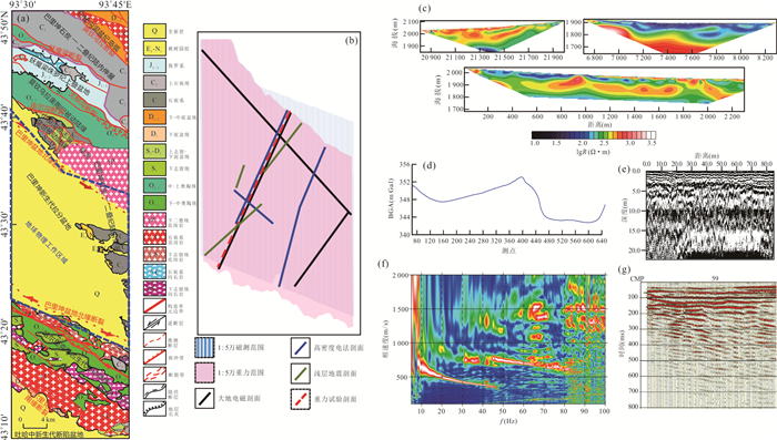
图 2 巴里坤盆地测区地球物理方法部署及其方法试验结果
a. 测区位置;b. 地球物理方法部署图;c. 高密度电法试验剖面;d. 重力试验剖面;e. 探地雷达试验剖面;f. 浅层地震面波法试验剖面的速度频散图;g. 浅层地震反射波法试验的剖面叠加记录
Fig. 2. The deployment of geophysical methods and experimental results in the survey area of the Barkol Basin

图 3 巴里坤盆地测区地球物理方法应用部分成果
a. 多信息约束下反演得到的双层覆盖结构;b. 重磁异常线性信息提取与解释的基岩地质图;c. 电阻率与磁化率联合解释基岩属性;d. 主动源/被动源面波联合反演的横波速度剖面(Luo et al., 2018);e. 高密度电法反演电阻率剖面与地下水结构解释
Fig. 3. The part achievements from geophysical methods in the survey area of the Barkol Basin
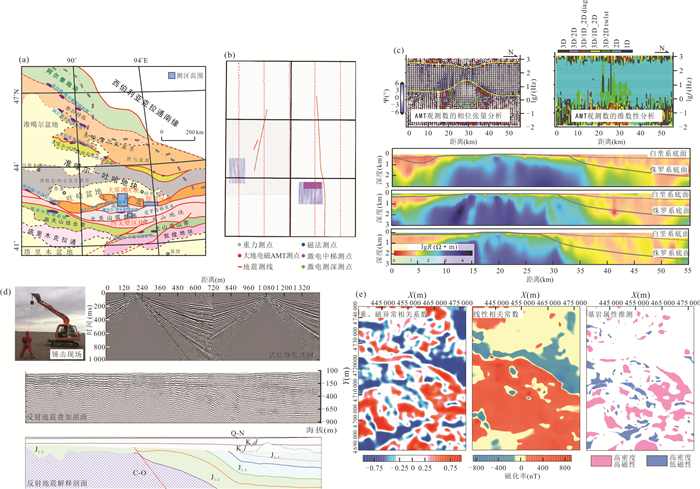
图 4 地球物理方法在喀拉塔格-雅满苏一带地质填图区域的部署与应用
a. 地质填图区域;b. 大草滩区块地球物理方法部署图;c. AMT数据处理与大草滩区块AMT剖面反演电阻率分布及双界面深度;d. 设计的用于戈壁荒漠地震勘探的锤击震源及应用效果;e. 大草滩区块重、磁异常对应分析及基岩属性推测
Fig. 4. The deployment of geophysical methods and their application in geological investigation area around the Karatag-Yamansu zone, Hami, Xinjiang
表 1 地质调查常用的地球物理方法特点对比
Table 1. Comparison of characteristics of geophysical methods used in geological survey
方法名称 调查方式 采集参数与场地要求 技术特点 实施成本* 重力法 面积、剖面 单参数测量,需配合高精度水准测量,适应各种地形 依据密度差异探测地质目标及构造,具有较好的横向分辨力,探测深度为地表-上地幔 较低 磁法 面积、剖面 单参数、多参数测量,适应各种地形 依据磁性差异探测地质目标及构造,具有较好的横向分辨力,探测深度为地表-居里面 低 电与电磁法 面积、剖面 多方法、多参数测量,可选择多种方法组合,不同装置可获得不同效果,要求地电干扰低 依据导电性和极化性差异探测地质目标及构造,具有较好的横向和一定的纵向分辨力,探测深度为地表-上地幔 中- 低 浅层地震法 剖面 多方法、多参数测量,多种选择,地形相对平坦,要求适当的地震地质条件 依据波速差异探测地质目标及构造,具有较好的横向和纵向分辨力,探测深度为地表至1 000 m 较高 放射性法 面积、剖面 单参数测量,适应各种地形 依据放射性差异探测地质目标属性,探测深度为地表至10 m 低 测井法** 井孔内 多方法、多参数测量,对钻孔施工有特殊技术要求 依据方法相应的物性差异探测井周地质目标及地层层位,探测范围为井周至10 m 较高 注:*表示依据国家现行地质调查预算编制规范,单位面积数据产出量估计的实施成本;**表示测井方法通常在任务要求下开展.  下载: 导出CSV
表 2 戈壁荒漠覆盖区不同深度覆盖层推荐的方法组合(以1∶5万填图为例)
Table 2. Geophysical method combination of different depth overburden in Gobi Desert covered area
覆盖厚度(m) 推荐使用的地球物理方法 1∶50 000重磁面积测量 1∶5 000~1∶10 000重磁剖面测量 电磁法(AMT/CSAMT/TEM) 探地雷达 浅层地震反射波法/面波法 高密度电法 0~3 〇 〇 〇 ● 〇 〇 3~20 ● ● ● ● ● ● 20~50 ● ● ● - ● ● 50~100 ● ● ● - ● ● > 100 ● ● ● - ● - 注:●表示推荐使用,〇表示可根据填图内容选用,-表示不推荐使用. 线距、点距等测网密度参数需要根据填图地区的地表、地质地球物理条件及填图内容确定,比如水文地质填图需要根据地形、地下潜水面、地下水来源及流向、断裂等导水通道分布、含水层及顶底板起伏等因素综合确定;对于基岩地质填图,一般以能控制主要岩石单元和断裂分布为依据合理布设地球物理测网.
下载: 导出CSV
-
Bourgine, B., Lasseur, É., Leynet, A., et al., 2017. Building a Geological Reference Platform Using Sequence Stratigraphy Combined with Geostatistical Tools. In: Gómez-Hernández, J.J., Rodrigo-Ilarri, J., Rodrigo-Clavero, M.E., et al., eds., Geostatistics Valencia 2016. Springer, Cham, 865-877. https://doi.org/10.1007/978-3-319-46819-8_60 Chandler, V. W., Koski, J. S., Hinze, W. J., et al., 1981. Analysis of Multisource Gravity and Magnetic Anomaly Data Sets by Moving-Window Application of Poisson's Theorem. Geophysics, 46(1): 30-39. https://doi.org/10.1190/1.1441136 Chen, H.H., 2014. Comprehensive Geophysical Methods Applied in Deep Geological Formations Coverage Area Is Divided In (Dissertation). China University of Geosciences, Beijing (in Chinese with English abstract). Chen, S., Chen, C.J., Wu, J., et al., 2017. Application and Exploration of Geophysical Methods in Geological Mapping in Strongly Weathered Area. Journal of Geomechanics, 23(2): 206-213 (in Chinese with English abstract). http://en.cnki.com.cn/Article_en/CJFDTOTAL-DZLX201702004.htm Cui, M.L., Zhang, B.L., Liang, G.H., et al., 2010. The Technical Combination of Comprehensive Geophysical Prospecting in the Molybdenum Mines with Loess-Covered: A Case Study at the Shapoling Molybdenum Mine. Progress in Geophysics, 25(2): 602-611 (in Chinese with English abstract). http://en.cnki.com.cn/Article_en/CJFDTOTAL-DQWJ201002036.htm Gulbrandsen, M. L., Minsley, B. J., Ball, L. B., et al., 2016. Semiautomatic Mapping of Permafrost in the Yukon Flats, Alaska. Geophysical Research Letters, 43(23): 12131-12137. https://doi.org/10.1002/2016gl071334 Hauck, C., Mühll, D.V., Maurer, H., 2003. Using DC Resistivity Tomography to Detect and Characterize Mountain Permafrost. Geophysical Prospecting, 51(4): 273-284. https://doi.org/10.1046/j.1365-2478.2003.00375.x Jørgensen, F., Lykke-Andersen, H., Sandersen, P. B. E., et al., 2003a. Geophysical Investigations of Buried Quaternary Valleys in Denmark: An Integrated Application of Transient Electromagnetic Soundings, Reflection Seismic Surveys and Exploratory Drillings. Journal of Applied Geophysics, 53(4): 215-228. https://doi.org/10.1016/j.jappgeo.2003.08.017 Jørgensen, F., Sandersen, P. B. E., Auken, E., 2003b. Imaging Buried Quaternary Valleys Using the Transient Electromagnetic Method. Journal of Applied Geophysics, 53(4): 199-213. https://doi.org/10.1016/j.jappgeo.2003.08.016 Liu, J.H., Wang, Z.W., Tian, G., et al., 2003. Application of Ground Gamma-Spectrometry in Geological Mapping in Shallow Overburden Areas. Geology and Prospecting, 39(2): 61-64 (in Chinese with English abstract). http://en.cnki.com.cn/Article_en/CJFDTOTAL-DZKT200302013.htm Liu, R., Ma, J.Q., Li, Q.C., et al., 2016. Gravity, Magnetic and Electric Comprehensive Geophysical Prospecting for Deep Structures in Hetao Basin. Journal of Geomechanics, 22(4): 943-954 (in Chinese with English abstract). http://en.cnki.com.cn/Article_en/CJFDTOTAL-DZLX201604012.htm Liu, Y., Liu, J. P., Chen, C., et al., 2020. The Application of Audio Magnetotelluric for 3D Geological Mapping in the Gobi Desert Area. Geological Journal, 55(11): 7335-7345. https://doi.org/10.1002/gj.3627 Luo, Y. H., Lin, J., Yang, Y. J., et al., 2018. Joint Inversion of Active Sources and Ambient Noise for Near-Surface Structures: A Case Study in the Balikun Basin, China. Seismological Research Letters, 89(6): 2256-2265. https://doi.org/10.1785/0220180140 Mathers, S. J., Terrington, R. L., Waters, C. N., et al., 2014. GB3D-A Framework for the Bedrock Geology of Great Britain. Geoscience Data Journal, 1(1): 30-42. https://doi.org/10.1002/gdj3.9 Minsley, B. J., Abraham, J. D., Smith, B. D., et al., 2012. Airborne Electromagnetic Imaging of Discontinuous Permafrost. Geophysical Research Letters, 39(2): L02503. https://doi.org/10.1029/2011gl050079 Sun, K., 2018. Research on Integrated Application of Geophysical Information on Geological Mapping of Barkol Basin (Dissertation). China University of Geosciences, Wuhan (in Chinese with English abstract). Sun, K., Chen, C., Du, J. S., et al., 2018. Determination of Cenozoic Sedimentary Structures Using Integrated Geophysical Surveys: A Case Study in the Barkol Basin, Xinjiang, China. Journal of Applied Geophysics, 148: 152-162. https://doi.org/10.1016/j.jappgeo.2017.10.015 Thorleifson, H., Berg, R., Russell, H., 2010. Geological Mapping Goes 3-D in Response to Societal Needs. GSA Today, 20(8): 27-29. https://doi.org/10.1130/gsatg86gw.1 Wang, G.C., Chen, C., Hu, J.M., et al., 2018. A Guide of 1: 50 000 Mapping Method for Gobi Desert Covered Area. Science Press, Beijing (in Chinese). Wang, G.C., Shen, T.Y., Chen, C., et al., 2020. Basin-Range Coupling and Tectonic Topography Analysis during the Geological Mapping on Covered Area: A Case Study of Turpan-Hami Basin, Eastern Tianshan. Earth Science (in Chinese with English abstract). https://doi.org/10.3799/dqkx.2020.300 Wang, G.C., Zhang, M., Feng, J.L., et al., 2019. New Understanding of the Tectonic Framework and Evolution during the Neoproterozoic-Paleozoic Era in the East Tianshan Mountains. Journal of Geomechanics, 25(5): 798-819 (in Chinese with English abstract). http://en.cnki.com.cn/Article_en/CJFDTotal-DZLX201905011.htm Wang, G.C., Zhao, X., Chen, C., et al., 2016. Exploration of Geological Mapping Methods on Covered Area of Faulted Basin in the Northwest China-A Mapping Practice in the Barkol Basin, Xinjiang. Journal of Geomechanics, 22(4): 809-821 (in Chinese with English abstract). http://en.cnki.com.cn/Article_en/CJFDTotal-DZLX201604002.htm Yang, X.P., Mei, Y.H., Li, S.C., et al., 2019. Comprehensive Geophysical Study on Stratigraphic Distribution Regularities and Tectonic Frameworks in Barkol Basin. Earth Science, 44(12): 4222-4234 (in Chinese with English abstract). http://en.cnki.com.cn/Article_en/CJFDTotal-DQKX201912033.htm Zeng, K., Chen, J.G., Xiao, F., et al., 2013. Study on Gravity and Magnetic Field Characteristics and Tectonic Framework in Gobi Desert in Eastern Tianshan Mountains. Journal of Geology, 37(4): 598-605 (in Chinese with English abstract). 陈浩辉, 2014. 综合物探方法在深覆盖区地质构造划分中的应用(硕士学位论文). 北京: 中国地质大学. 陈松, 陈长敬, 吴俊, 等, 2017. 物探方法在强风化区填图中的应用探索. 地质力学学报, 23(2): 206-213. https://www.cnki.com.cn/Article/CJFDTOTAL-DZLX201702004.htm 崔敏利, 张宝林, 梁光河, 等, 2010. 黄土覆盖区钼矿综合地球物理找矿技术组合: 以沙坡岭钼矿为例. 地球物理学进展, 25(2): 602-611. doi: 10.3969/j.issn.1004-2903.2010.02.033 刘菁华, 王祝文, 田钢, 等, 2003. 地面伽马能谱测量在浅覆盖区地质填图中的应用. 地质与勘探, 39(2): 61-64. https://www.cnki.com.cn/Article/CJFDTOTAL-DZKT200302013.htm 刘嵘, 马见青, 李庆春, 等, 2016. 重磁电综合地球物理探测河套盆地深部结构. 地质力学学报, 22(4): 943-954. doi: 10.3969/j.issn.1006-6616.2016.04.012 孙凯, 2018. 巴里坤盆地地质填图中地球物理信息综合应用研究(博士学位论文). 武汉: 中国地质大学. 王国灿, 陈超, 胡建民, 等, 2018. 戈壁荒漠覆盖区1: 50 000填图方法指南. 北京: 科学出版社. 王国灿, 申添毅, 陈超, 等, 2020. 覆盖区地质调查中的盆山构造地貌关系研究: 以东天山-吐哈盆地为例. 地球科学. https://doi.org/10.3799/dqkx.2020.300 王国灿, 张孟, 冯家龙, 等, 2019. 东天山新元古代-古生代大地构造格架与演化新认识. 地质力学学报, 25(5): 798-819. https://www.cnki.com.cn/Article/CJFDTOTAL-DZLX201905011.htm 王国灿, 赵璇, 陈超, 等, 2016. 西北断陷盆地覆盖区填图方法探索——新疆巴里坤盆地填图实践. 地质力学学报, 22(4): 809-821. doi: 10.3969/j.issn.1006-6616.2016.04.002 杨小鹏, 梅岩辉, 李世超, 等, 2019. 巴里坤盆地地层展布规律和构造格架的综合地球物理认识. 地球科学, 44(12): 4222-4234. doi: 10.3799/dqkx.2019.169 曾凯, 陈建国, 肖凡, 等, 2013. 东天山戈壁沙漠覆盖区重磁场特征与构造格架研究. 地质学刊, 37(4): 598-605. doi: 10.3969/j.issn.1674-3636.2013.04.598 -

 点击查看大图
计量
- 文章访问数: 1549
- HTML全文浏览量: 1019
- PDF下载量: 111
- 被引次数: 0
