


Distribution and Risk of Ice Avalanche Hazards in Tibetan Plateau
-
摘要:
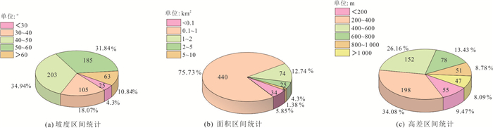
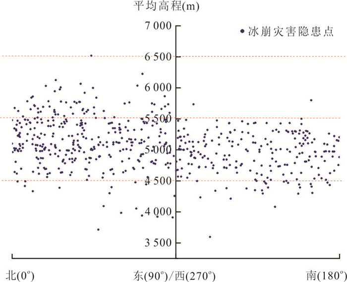
随着全球气候变暖,青藏高原冰崩灾害日益加剧.通过大量遥感解译及数据分析,系统查明青藏高原冰崩隐患数量、类型、发育规律及危险性:(1)40 269条冰川共发育冰崩隐患581处.按失稳方式分为滑移式和崩落式;按成灾模式分为冰崩直接灾害、冰崩-堵江溃决和冰崩-冰湖溃决灾害.(2)冰崩敏感坡度40°~50°,集中分布高程为4 500~5 500 m,坡向具有“亲北性”.(3)区域分布差异大.西藏和新疆区域分布共占89.5%,雅鲁藏布江和塔里木河流域分布共占80.4%,念青唐古拉山脉和横断山脉分布共占49.4%.(4)空间分异明显.冰崩前缘高程以喜马拉雅东构造结为界,以西呈自西向东增大的趋势,以东呈先减小后增大的“V”型趋势,40.1%的冰崩前缘高程4 500~5 000 m、位于雪线附近,受山脉控制具有气候带交界“群聚性”特点.(5)高危险的冰崩隐患点36处、中等危险215处、低危险330处.
Abstract:With the impact of global warming, the ice avalanche disaster on the Tibetan plateau is becoming more and more serious. Through a large number of remote sensing interpretations and data analysis, the number, types, development patterns and dangers of the hidden ice avalanches on the Tibetan plateau were identified systematically. (1) There are a total of 581 hidden dangers of ice avalanches in 40 269 glaciers. According to the mode of instability, they are divided into sliding type and caving type; according to the disaster mode, they are divided into the direct disaster of the ice avalanche, dammed lake outburst flood and glacial lake outburst flood. (2) The sensitive slope of ice avalanche is 40°-50°, and the concentrated elevation is 4 500-5 500 m, and the slope direction is "northern-friendly". (3) Obvious differences in regional distribution. Tibet and Xinjiang account for 89.5%, Yarlung Zangbo River and Tarim River basins account for 80.4%, Nyainqentanglha and Hengduan Mountains accounted for 49.4%. (4) Significant differentiation in spatial distribution. The elevation of the front edge of the ice avalanche changed regularly with the eastern Himalayan syntaxis region as the boundary. The elevation generally increased from west to east toward the west, while a "V"-shaped trend that first decreased and then increased toward the east. 40.1% of the ice avalanches front elevation was 4 500-5 000 m, located near the snow line and controlled by mountains. It had the characteristics of "clustering" at the junction of climatic zones. (5) There are 330 low-risk ice avalanches, 215 medium-risk points, and 36 high-risk points.
-
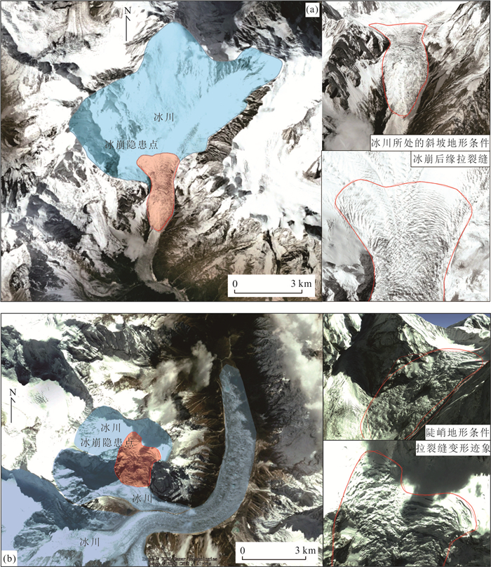
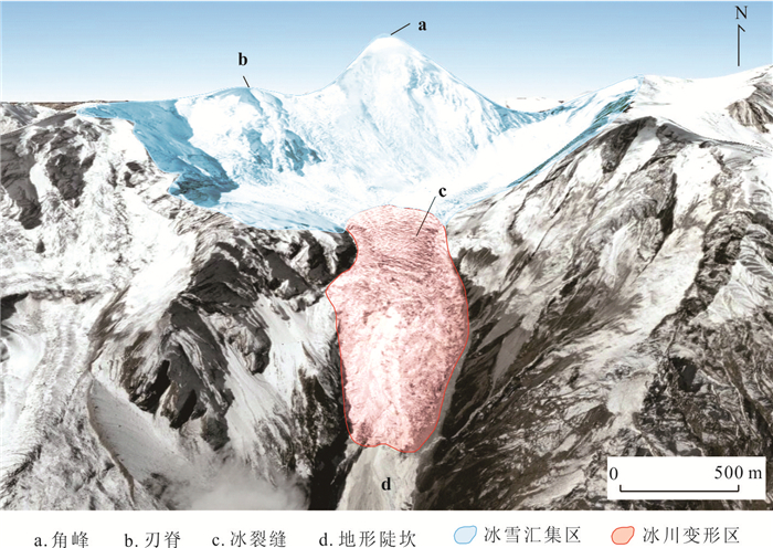
图 3 冰崩解译示例
a.影像色调为浅灰色,悬挂于冰川前沿冰舌处,坡度约40°;b.冰崩后缘拉张裂隙发育, 碎屑堆积体两侧铲刮明显; 蓝色为所属冰川区域,红色为冰崩隐患区
Fig. 3. Example of remote sensing interpretation for ice avalanche
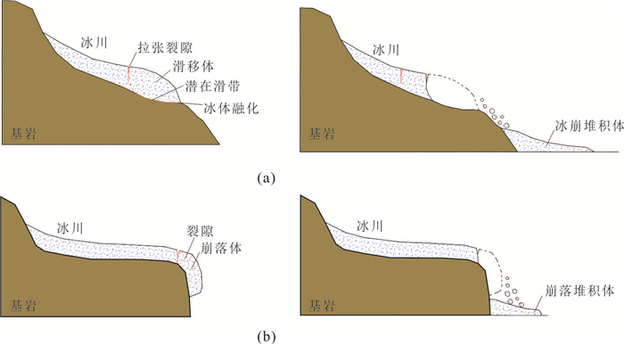
图 5 冰崩失稳模式分类
a.滑移式冰崩及变形失稳模式; b.崩落式冰崩及变形失稳模式
Fig. 5. Ice avalanche divided by moving mode
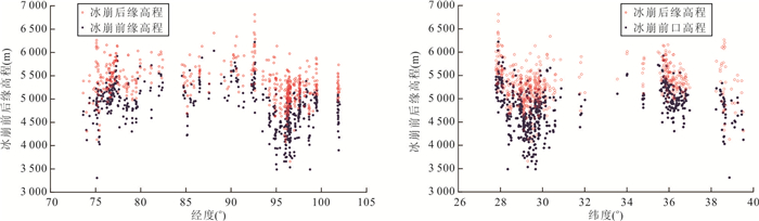
图 12 冰崩隐患前后缘高程分布与经纬度关系
Fig. 12. Relation between latitude and longitude with the back edge and toe elevation of ice avalanche
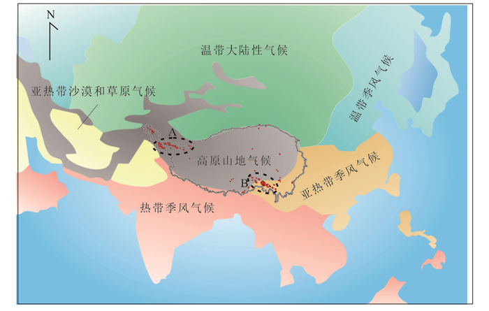
图 14 青藏高原气候类型分布示意
Fig. 14. Distribution of climate types in Tibetan plateau of ice avalanche and temperature
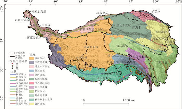
图 16 青藏高原冰崩灾害隐患危险性分区分布
Fig. 16. Distribution of different risks of ice avalanche in Tibetan plateau
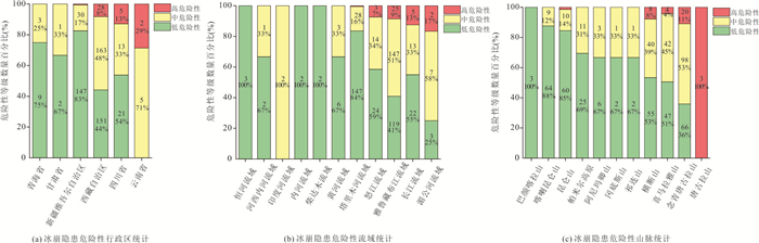
图 18 冰崩隐患危险性行政区划、流域、山脉统计
Fig. 18. Statistics of administrative division, river basin and mountain range of potential risk of ice avalanche
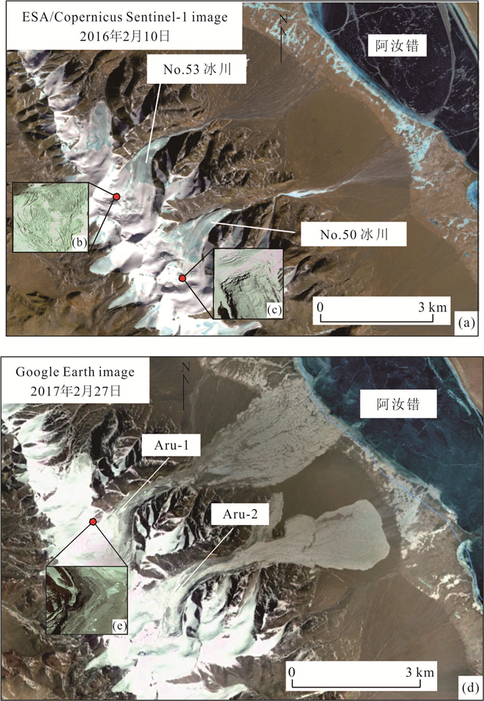
图 19 阿汝错冰崩发生前后遥感影像对比
a.冰崩发生前冰川全貌(引自http://jern.uio.no/remotesensing/gaphaz.);b.冰川表面揉皱破碎化;c.后缘冰裂隙发育;d.冰崩发生后冰川全貌;e.冰崩解体物质铲刮裹挟表面堆积体,基岩出露
Fig. 19. Comparison of remote sensing images before and after the Aru ice avalanches
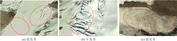
表 1 裂隙发育程度分类
Table 1. Assessment of development of ice crevasses
发育程度 裂隙数(组) 分布密度 描述 弱发育 < 5 稀疏 分布密度较小,裂缝张开度小,裂面较粗糙,延伸不远 中等发育 5~10 较密集 居于两者之间 强发育 > 10 密集 分布密度较大;裂缝张开度大,裂面较平直,延伸较远  下载: 导出CSV
表 2 冰崩危险性评价因子
Table 2. Factors of risk assessment of ice avalanche
符号 因子 描述 S1 坡度(°) 坡度对冰崩的发生有明显的控制作用,不仅决定斜坡的应力分布特征,而且影响着冰雪覆盖物、地表径流、坡体松散物的堆积.一般地面坡度越大,冰崩发生的规模和概率也越大 S2 坡向(°) 不同坡向的太阳辐射强度不同,进而影响坡面冰雪覆盖度和蒸发情况 S3 前后缘相对高差
(m)冰崩最大高程与最小高程的差值,体现了冰崩的空间几何特点.高差决定了冰崩势能累积能力的大小,高差越大,灾害发生时的动能也越大 S4 面积(km2) 面积在一定程度上体现了冰储量大小,直接决定了冰崩的物源物质条件;结合坡度S1和高差S3能有效反映冰崩的空间几何特征 S5 裂缝发育程度 冰川表面裂隙密度越大,间距越宽,延伸越长,局部冰体越易沿此裂缝脱离崩落,裂隙发育为冰崩的形成提供有利的物质结构条件 S6 平均月最高气温
(℃/a)气温上升加速冰雪消融,对冰川规模、面积、退缩速度有直接影响,易降低覆盖冰雪稳定性 S7 多年平均降雨量(mm/a) 降雨增加有利于冰川补给,为冰崩提供充足的物源,在雨水冲刷作用下易降低冰雪覆盖层的稳定,降雨量越大危险性越高 S8 距最近构造距离
(km)断裂等地质构造的分布往往影响滑坡、崩塌、地震等灾害发生,构造越发育,坡体稳定性越差,冰崩也有沿断裂带分布的特征 S9 地震发育密度
(次/ km2)地震烈度、震级、次数是冰崩灾害的关键诱因,提取冰崩半径100 km范围内≥5级地震的发生次数,数值越大引发冰崩的规模和概率就越大
下载: 导出CSV
表 3 评价因子权重值
Table 3. Weight of assessment factors
评价因子 S1 S2 S3 S4 S5 S6 S7 S8 S9 权重 0.230 7 0.028 8 0.147 2 0.227 4 0.143 8 0.084 5 0.063 6 0.043 6 0.030 4
下载: 导出CSV
表 4 冰崩危险性评价因子基准值划分
Table 4. Benchmark values of assessing factors of ice avalanche
评价因子 低危险(V1) 中危险(V2) 高危险(V3) 坡度(°)/S1 ≤ 25 (25,45) ≥ 45 坡向(°)/S2 N NE、E、SE、
SW、W、NWS 前后缘相对高差(m)/S3 ≤ 500 (500,1 000) ≥ 1 000 面积(km2)/S4 ≤ 1 (1,2) ≥ 2 裂缝发育程度/S5 弱发育 中等发育 强发育 月平均最高温度(℃)/S6 ≤ -5 (-5,5) ≥ 5 年平均降雨量(mm)/S7 ≤ 300 (300,600) ≥ 600 距最近断裂距离(km)/S8 ≥ 10 (1,10) ≤ 1 地震发育密度(次/半径km)/S9 ≤ 5 (5,10) ≥ 10
下载: 导出CSV
表 5 冰崩灾害点危险性等级划分统计
Table 5. Statistics of different risk grades
等级 冰崩个数 占比(%) 低危险性 330 56.80 中危险性 215 37.00 高危险性 36 6.20
下载: 导出CSV
-
An, G. Y., Han, L., Tu, J. N., et al., 2019. Remote Sensing Survey on Glacial Dynamic Evolution in the Himalayas in China during 1999—2015. Geoscience, 33(5): 1086-1097(in Chinese with English abstract). Chai, B., Tao, Y. Y., Du, J., et al., 2020. Hazard Assessment of Debris Flow Triggered by Outburst of Jialong Glacial Lake in Nyalam County, Tibet. Earth Science, 45(12): 4630-4639(in Chinese with English abstract). Chen, X. Q., Cui, P., Yang, Z., et al., 2005. Change in Glaciers and Glacier Lakes in Boiqu River Basin, Middle Himalayas during Last 15 Years. Journal of Glaciology and Geocryology, 27(6): 793-800(in Chinese with English abstract). doi: 10.3969/j.issn.1000-0240.2005.06.002 Du, G. L., 2017. Development Characteristics and Hazard Assessment of Landslide in the Eastern Himalayan Syntaxis Region of Tibetan Plateau (Dissertation). Chinese Academy of Geological Sciences, Beijing(in Chinese with English abstract). Frauenfelder, R., 2005. Regional-Scale Modelling of the Occurrence and Dynamics of Rock Glaciers and the Distribution of Paleo Permafrost (Dissertation). University of Zurich, Switzerland. Gallo, F., Lavé, J., 2014. Evolution of a Large Landslide in the High Himalaya of Central Nepal during the Last Half-Century. Geomorphology, 223: 20-32. https://doi.org/10.1016/j.geomorph.2014.06.021 Hu, W. T., Yao, T. D., Yu, W. S., et al., 2018. Advances in the Study of Glacier Avalanches in High Asia. Journal of Glaciology and Geocryology, 40(6): 1141-1152(in Chinese with English abstract). Huang, F. M., Ye, Z., Yao, C., et al., 2020. Uncertainties of Landslide Susceptibility Prediction: Different Attribute Interval Divisions of Environmental Factors and Different Data-Based Models. Earth Science, 45(12): 4535-4549(in Chinese with English abstract). Janke, J. R., Bellisario, A. C., Ferrando, F. A., 2015. Classification of Debris-Covered Glaciers and Rock Glaciers in the Andes of Central Chile. Geomorphology, 241: 98-121. https://doi.org/10.1016/j.geomorph.2015.03.034 Kääb, A., 2007. Periglacial Landforms, Rock Forms Rock Glaciers and Protalus Forms. In: Elias, S. A., ed., Encyclopedia of Quaternary Science. Elsevier, Amsterdam, 2236-2242. https://doi.org/10.1016/b0-44-452747-8/00114-9 Kääb, A., Leinss, S., Gilbert, A., et al., 2018. Massive Collapse of Two Glaciers in Western Tibet in 2016 After Surge-Like Instability. Nature Geoscience, 11: 114-123. https://doi.org/10.1038/s41561-017-0039-7 Kritikos, T., Robinson, T., Davies, T., 2015. Regional Coseismic Landslide Hazard Assessment without Historical Landslide Inventories: A New Approach. Journal of Geophysical Research: Earth Surface, 120: 711-729. https://doi.org/10.1002/2014jf003224 Liu, C. Z., Lü, J. T., Tong, L. Q., et al., 2019. Research on Glacial/Rock Fall-Landslide-Debris Flows in Sedongpu Basin along Yarlung Zangbo River in Tibet. Geology in China, 46(2): 219-234(in Chinese with English abstract). Liu, S. Y., Guo, W. Q., Xu, L. J., 2012. The Second Glacier Inventory Dataset of China (version 1.0) (2006—2011). National Tibetan Plateau Data Center, Beijing (in Chinese). https://doi.org/10.3972/glacier.001.2013.db Liu, S. Y., Yao, X. J., Guo, W. Q., et al., 2015. The Contemporary Glaciers in China Based on the Second Chinese Glacier Inventory. Acta Geographica Sinica, 70(1): 3-16(in Chinese with English abstract). Liu, Z. X., Su, Z., Yao, T. D., et al., 2000. Glacier Resources and Their Distribution Characteristics in Qinghai-Tibet Plateau. Resources Science, 22(5): 49-52(in Chinese with English abstract). doi: 10.3321/j.issn:1007-7588.2000.05.011 Mahboob, M. A., Iqbal, J., Atif, I., 2015. Modeling and Simulation of Glacier Avalanche: A Case Study of Gayari Sector Glaciers Hazards Assessment. IEEE Transactions on Geoscience and Remote Sensing, 53(11): 5824-5834. https://doi.org/10.1109/tgrs.2015.2419171 Pandey, P., 2019. Inventory of Rock Glaciers in Himachal Himalaya, India Using High-Resolution Google Earth Imagery. Geomorphology, 340: 103-115. https://doi.org/10.1016/j.geomorph.2019.05.001 Pei, L. X., 2019. The Preliminary Study of Characteristics and Types of Ice Avalanche Disaster in the Tibetan Plateau (Dissertation). China University of Geosciences, Beijing (in Chinese with English abstract). Pellicani, R., van Westen, C. J., Spilotro, G., 2014. Assessing Landslide Exposure in Areas with Limited Landslide Information. Landslides, 11(3): 463-480. https://doi.org/10.1007/s10346-013-0386-4 Peng, S. Z., 2019a. High-Spatial-Resolution Monthly Precipitation Dataset over China during 1901—2017. Earth System Science Data, 11(4): 1931-1946. https://doi.org/10.5281/zenodo.3114194 Peng, S. Z., 2019b. High-Spatial-Resolution Monthly Temperatures Dataset over China during 1901—2017. Earth System Science Data, 11(4): 1931-1946. https://doi.org/10.5281/zenodo.3185722 Pralong, A., Funk, M., 2006. On the Instability of Avalanching Glaciers. Journal of Glaciology, 52(176): 31-48. https://doi.org/10.3189/172756506781828980 Salzmann, N., Kääb, A., Huggel, C., et al., 2004. Assessment of the Hazard Potential of Ice Avalanches Using Remote Sensing and GIS-Modelling. Norsk Geografisk Tidsskrift-Norwegian Journal of Geography, 58(2): 74-84. https://doi.org/10.1080/00291950410006805 Shi, L. N., Ji, X. F., Wang, X., 2017. Extraction of Ice Collapse Range in Ali, Tibet Using Sentinel-2A Data. Inner Mongolia Coal Economy, (2): 157-160(in Chinese). doi: 10.3969/j.issn.1008-0155.2017.02.083 Sun, M. P., Liu, S. Y., Yao, X. J., et al., 2014. The Cause and Potential Hazard of Glacial Lake Outburst Flood Occurred on July 5, 2013 in Jiali County, Tibet. Journal of Glaciology and Geocryology, 36(1): 158-165(in Chinese with English abstract). Sun, S. W., Kang, S. C., Zhang, Q. G., et al., 2020. Mercury in Cryosphere of the Tibetan Plateau and Its Environmental Significance. Chinese Journal of Nature, 42(5): 364-372(in Chinese with English abstract). doi: 10.3969/j.issn.0253-9608.2020.05.002 Tong, L. Q., Pei, L. X., Tu, J. N., et al., 2020. A Preliminary Study of Definition and Classification of Ice Avalanche in the Tibetan Plateau Region. Remote Sensing for Land & Resources, 32(2): 11-18(in Chinese with English abstract). Tong, L. Q., Tu, J. N., Pei, L. X., et al., 2018. Preliminary Discussion of the Frequently Debris Flow Events in Sedongpu Basin at Gyalaperi Peak, Yarlung Zangbo River. Journal of Engineering Geology, 26(6): 1552-1561(in Chinese with English abstract). Wang, J., 2020. Earthquake Catalogue with M≥5 in Pan-Third Pole since 1960. National Tibetan Plateau Data Center, Beijing (in Chinese). Wu, G. J., Yao, T. D., Wang, W. C., et al., 2019. Glacial Hazards on Tibetan Plateau and Surrounding Alpines. Bulletin of Chinese Academy of Sciences, 34(11): 1285-1292(in Chinese with English abstract). Xue, Y. G., Kong, F. M., Yang, W. M., et al., 2020. Main Unfavorable Geological Conditions and Engineering Geological Problems along Sichuan-Tibet Railway. Chinese Journal of Rock Mechanics and Engineering, 39(3): 445-468(in Chinese with English abstract). Zhang, Y. L., Li, B. Y., Zheng, D., 2002. A Discussion on the Boundary and Area of the Tibetan Plateau in China. Geographical Research, 21(1): 1-8(in Chinese with English abstract). 安国英, 韩磊, 涂杰楠, 等, 2019. 中国喜马拉雅山地区冰川1999—2015年期间动态变化遥感调查. 现代地质, 33(5): 1086-1097. https://www.cnki.com.cn/Article/CJFDTOTAL-XDDZ201905017.htm 柴波, 陶阳阳, 杜娟, 等, 2020. 西藏聂拉木县嘉龙湖冰湖溃决型泥石流危险性评价. 地球科学, 45(12): 4630-4639. doi: 10.3799/dqkx.2020.294 陈晓清, 崔鹏, 杨忠, 等, 2005. 近15a喜马拉雅山中段波曲流域冰川和冰湖变化. 冰川冻土, 27(6): 793-800. 杜国梁, 2017. 喜马拉雅东构造结地区滑坡发育特征及危险性评价(博士学位论文). 北京: 中国地质科学院. 胡文涛, 姚檀栋, 余武生, 等, 2018. 高亚洲地区冰崩灾害的研究进展. 冰川冻土, 40(6): 1141-1152. https://www.cnki.com.cn/Article/CJFDTOTAL-BCDT201806008.htm 黄发明, 叶舟, 姚池, 等, 2020. 滑坡易发性预测不确定性: 环境因子不同属性区间划分和不同数据驱动模型的影响. 地球科学, 45(12): 4535-4549. doi: 10.3799/dqkx.2020.247 刘传正, 吕杰堂, 童立强, 等, 2019. 雅鲁藏布江色东普沟崩滑-碎屑流堵江灾害初步研究. 中国地质, 46(2): 219-234. https://www.cnki.com.cn/Article/CJFDTOTAL-DIZI201902002.htm 刘时银, 郭万钦, 许君利, 2012. 中国第二次冰川编目数据集(V1.0)(2006—2011). 北京: 国家青藏高原科学数据中心. 刘时银, 姚晓军, 郭万钦, 等, 2015. 基于第二次冰川编目的中国冰川现状. 地理学报, 70(1): 3-16. https://www.cnki.com.cn/Article/CJFDTOTAL-DLXB201501002.htm 刘宗香, 苏珍, 姚檀栋, 等, 2000. 青藏高原冰川资源及其分布特征. 资源科学, 22(5): 49-52. https://www.cnki.com.cn/Article/CJFDTOTAL-ZRZY200005010.htm 裴丽鑫, 2019. 青藏高原地区冰崩灾害特征与类型的初步研究(硕士学位论文). 北京: 中国地质大学. 时丽娜, 藉雪峰, 王星, 2017. 利用Sentinel-2A数据的西藏阿里冰崩范围提取. 内蒙古煤炭经济, (2): 157-160. https://www.cnki.com.cn/Article/CJFDTOTAL-LMMT201702083.htm 孙美平, 刘时银, 姚晓军, 等, 2014.2013年西藏嘉黎县"7•5"冰湖溃决洪水成因及潜在危害. 冰川冻土, 36(1): 158-165. https://www.cnki.com.cn/Article/CJFDTOTAL-BCDT201401020.htm 孙世威, 康世昌, 张强弓, 等, 2020. 青藏高原冰冻圈汞研究及其环境意义. 自然杂志, 42(5): 364-372. https://www.cnki.com.cn/Article/CJFDTOTAL-ZRZZ202005003.htm 童立强, 裴丽鑫, 涂杰楠, 等, 2020. 冰崩灾害的界定与类型划分: 以青藏高原地区为例. 国土资源遥感, 32(2): 11-18. https://www.cnki.com.cn/Article/CJFDTOTAL-GTYG202002002.htm 童立强, 涂杰楠, 裴丽鑫, 等, 2018. 雅鲁藏布江加拉白垒峰色东普流域频繁发生碎屑流事件初步探讨. 工程地质学报, 26(6): 1552-1561. https://www.cnki.com.cn/Article/CJFDTOTAL-GCDZ201806017.htm 王继, 2020.1960年以来泛第三极地区5级以上地震目录. 北京: 国家青藏高原科学数据中心. 邬光剑, 姚檀栋, 王伟财, 等, 2019. 青藏高原及周边地区的冰川灾害. 中国科学院院刊, 34(11): 1285-1292. https://www.cnki.com.cn/Article/CJFDTOTAL-KYYX201911012.htm 薛翊国, 孔凡猛, 杨为民, 等, 2020. 川藏铁路沿线主要不良地质条件与工程地质问题. 岩石力学与工程学报, 39(3): 445-468. 张镱锂, 李炳元, 郑度, 2002. 论青藏高原范围与面积. 地理研究, 21(1): 1-8. https://www.cnki.com.cn/Article/CJFDTOTAL-DLYJ200201000.htm -


 点击查看大图
计量
- 文章访问数: 2092
- HTML全文浏览量: 984
- PDF下载量: 176
- 被引次数: 0
