


Formation of East Lake, Wuhan, Eastern China
-
摘要: 东湖位于湖北省武汉市中心城区,是中国乃至亚洲最大的城中湖之一.她是首批国家重点风景名胜区和国家5A级旅游景区.武汉市正在打造东湖城市生态绿心.东湖对于武汉在资源、环境、生态、人文各方面均具有重要意义.关于东湖的成因长期众说纷纭.研究首次从地质、地貌、沉积等方面对东湖的成因进行了分析,并对东湖与长江的关系进行了讨论.(1)东湖位于中-晚更新世形成的岗地区.湖汊发育,岸线蜿蜒,岬湾交错,是东湖最大的特点.(2)东湖的湖相沉积厚度各处不一,总体呈现南薄北厚、边缘薄中间厚的特点.下伏主要地层为晚更新世下蜀黄土,在靠近基岩残丘的南部边缘局部为晚更新世坡积层,两者之间为明显的侵蚀接触关系.(3)东湖的湖盆形成于距今2万年左右的末次冰期盛期.东海海平面的大幅度下降,长江河床深切.发育于长江南岸珞珈山、南望山、喻家山一带的地表径流,在汇入长江时因江水水位较低而发生侵蚀,形成多条冲沟组合而成的侵蚀洼地.之后,随着冰后期的全球变暖,长江水位快速上升,两岸天然堤发育、壮大,使侵蚀洼地的出口被淤塞,逐渐积水成湖,即东湖为沟谷壅塞湖.(4)根据湖泊地质地貌特征,东湖与沙湖是两个不同成因且相对独立的湖泊;长江并未经东湖流过.但东湖的形成与长江有关,乃是全球气候变化驱动下海、江、湖相互作用的产物.(5)东湖之美,美于自然.保护其自然特质,顺应其自然规律,是东湖保护与利用必须坚持的原则.将湖域、湖岸、岸上作为一个整体,将水域和流域作为一个系统,按照山水林田湖草生命共同体的科学理念,对东湖进行整体性和系统性的保护与治理是十分必要的.Abstract: The East Lake, located in the downtown of Wuhan city, Hubei Province, is the largest city lake in China or even in Asia. It is one of the first batches of national key scenic spots and 5A tourist attractions, and has been an important water source area for industrial, agricultural production and aquatic base in Wuhan. Nowadays, in Wuhan it building the ecological green heart of East Lake, therefore there is great significance for resources, environment, ecology and humanity. However, the formation cause of the East Lake has long been disputed. This study is the first one to analyze the origin of the East Lake from many aspects, including geology, geomorphology and sedimentation, further to discuss the relationship between the East Lake and the Yangtze River. The main conclusions are as follow: (1) The geomorphological characteristics of the lake: branching, meandering coastline and headlands and bays, this is generally developed on the hillock of Middle-Late Pleistocene. (2) The thickness of lacustrine sediments in East Lake is various, showing thin in the south and thick in the north, thin in the margin and thick in the middle. The underlying strata are mainly the Late Pleistocene Xiashu loess, and the Late Pleistocene slope layer is locally distributed near the southern margin of the bedrock residual mound. There is an obvious unconformable relationship between lacustrine sediments and Xiashu loess. (3) The basin of East Lake was formed in the last glacial maximum (LGM) about 20 ka ago. In this time, the sea level of the East China Sea has dropped sharply, and induced the riverbed of the Yangtze River incised. The Luojia, Nanwang and Yujia mountains on the south bank of the Yangtze River were deeply incised landscape when it flowed into the Yangtze River due to low erosion baseline of the LGM, resulting in a series of gullies. After that, the Holocene global warming and high sea-level, the water surface of the Yangtze River rose rapidly, and the natural dikes along its banks developed and expanded with resultant in filling of the incised gullies, accounted for the formation of lake. Based on the above analyses, the East Lake was a gully choked lake. (4) According to the characteristics of geology and geomorphology, the East Lake and Shahu Lake are two independent lakes with different formation processes. The Yangtze River does not flow through the East Lake, however, the formation of the East Lake is related to the Yangtze River, which is the result of the complex feedback of the East China Sea-Yangtze River-East Lake, this process was driven by global climate change.(5)The worth of the East Lake lies in nature. Protecting its natural characteristics and conforming its natural laws is principles of protection and utilization of the East Lake. As a whole, for the scientific concept of mountain-water-forest-paddy-lake-grass community, it is necessary to regard lake shore and landform as a whole and regard catchment and basin as a whole to protect and manage the East Lake in a holistic and systematic way.
-
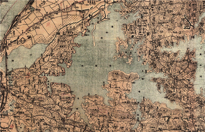
图 2 东湖的自然形态特征(据1919年磨山幅地形图)
Fig. 2. Natural morphological characteristics of East Lake (according to the Moshan topographic map in 1919)
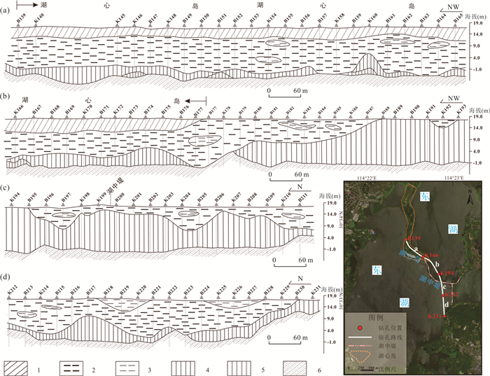
图 3 东湖下穿通道磨山湖岸-湖心岛段地质剖面
1.人工填土;2.全新世湖相层;3.全新世砂质黏土;4.晚更新世下蜀土;5.中更新世红土;6.公安寨组砂岩
Fig. 3. Geological section from Moshan Lakeshore to mid-lake island of East Lake underpass

图 4 两湖隧道东湖水下段钻孔联孔剖面
1. 全新世湖相层;2.晚更新世下蜀土;3.中更新世红土;4.更新世坡积物;5.公安寨组砂岩6.角度不整合
Fig. 4. Section of conjoined borehole in East Lake underwater section of Lianghu tunnel

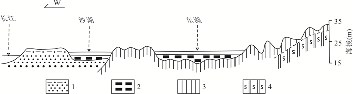
图 6 东湖和沙湖之间的岗梁(1927年美国陆军测绘,1∶25 000)
Fig. 6. Ridge between East Lake and Shahu Lake (Mapping by US Army in 1927, 1∶25 000)
-
Cai, S.M., Guan, Z.H., 1979. Study on Lake Geology (Quaternary Period) of Lake Dong Hu, Wuhan, Hubei Province, China: With Comments on Its Formation and on Ancient Yun Meng Swamp. Oceanologia et Limnologia Sinica, 10(4): 383-394(in Chinese with English abstract). Cai, S.M., Guan, Z.H., 1982. The Ungrounded Hypothesis of the Presence of the Ancient Yun Meng Swamp Traversing South and North of River Yangtze River on the Jianghan-Dongting Plain: Second Comments on the Ancient Yun Meng Swamp. Oceanologia et Limnologia Sinica, 13(2): 129-142(in Chinese with English abstract). Cao, G.J., Wang, J., Wang, L.J., et al., 2010. Characteristics and Runoff Volume of the Yangtze River Paleo-Valley at Nanjing Reach in the Last Glacial Maximum. Journal of Geographical Sciences, 20(3): 431-440. https://doi.org/10.1007/s11442-010-0431-3 Chen, L.F., 2012. Rentong's Sand Lake Annals and Yangduo's Sand Lake Three Songs. Wuhan Literature and History Data, (3): 58-60(in Chinese). Geological Geology Teaching and Research Group, Wuhan Institute of Surveying and Mapping, 1959. Survey Report on Geology and Geomorphology near Luo Jiashan. Journal of Wuhan Institute of Surveying and Mapping, (2): 89-99(in Chinese). Gu, Y.S., Li, X.Y., Qiu, H.O., et al., 2008. Sediments Records of Eutrophication History in the Donghu Lake, Wuhan, over the Past 100 Years. Ecology and Environment, 17(1): 35-40(in Chinese with English abstract). Guo, W., 1999. Ren Tong and the Construction of East Lake Scenic Area. Construction of the Yangtze River, (5): 30-31(in Chinese). He, B.Y., 2002. The Origin Types and Their Characteristics of the Lakes in Jianghan Plain. Journal of Central China Normal University (Natural Sciences), 36(2): 241-244(in Chinese with English abstract). Lambeck, K., Rouby, H., Purcell, A., et al., 2014. Sea Level and Global Ice Volumes from the Last Glacial Maximum to the Holocene. Proceedings of the National Academy of Sciences of the United States of America, 111(43): 15296-15303. https://doi.org/10.1073/pnas.1411762111 Li, C.A., 2018a. "A Game of Chess" in the Yangtze River Economic Belt Based on Systematic Thinking. People's Political Consultative Conference, 2018-5-8(3)(in Chinese). Li, C.A., 2018b. Countermeasures and Suggestions on Strengthening the Protection of Urban Lakes Shoreline in Hubei Province. Reform Research, (3): 61-64(in Chinese). Li, C.A., Yin, H.F., Yu, L.Z., et al., 2000. Concept Model on the Fluvial Environmental System: Mountain-River-Lake-Sea Interaction and Sensitive Responding to Global Change. Resources and Environment in the Yangtze Basin, 9(3): 358-363(in Chinese with English abstract). Li, C.A., Zhang, Y.F., Li, G.Q., 2021. Genetic Classification of Lakes in Wuhan Based on River and Lake Geological Process. Earth Science(in press). Local Chorography Compiling Committee of Wuchang District, 2008. Annals of Wuchang District. Wuhan Press, Wuhan, 91-93(in Chinese). Ma, T., Shen, S., Deng, Y.M., et al., 2020. Theoretical Approaches of Survey on Earth's Critical Zone in Basin: An Example from Jianghan Plain, Central Yangtze River. Earth Science, 45(12): 4498-4511(in Chinese with English abstract). Ren, T., 1926. Annals of Shahu. The Mimeographs Holded by National Library, Beijing, 12(in Chinese). Tu, G.P., Zhang, Y.F., Li, C.A., et al., 2021. Study on the Evolution of Yingwuzhou and Related Discussion. Journal of Central China Normal University (Natural Sciences), 55(1): 98-109(in Chinese with English abstract). Wu, B.L., 1963. The Genesis of East Lake. Wuhan Evening News, 1963-3-25(3)(in Chinese). Xi, C.F., 1965. Some Problems of Red Weathering Crust in China. China Quaternary Studies, 4(2): 42-54(in Chinese). Xia, Z.M., 2017. The Changes of Shahu in Wuhan in Historical Period. History and Geography, (1): 46-53(in Chinese). Xu, Y.T., Lai, Z.P., Li, C.A., 2019. Sea-Level Change as the Driver for Lake Formation in the Yangtze Plain: A Review. Global and Planetary Change, 181: 102980. https://doi.org/10.1016/j.gloplacha.2019.102980 Yang, H.R., Chen, Q.Y., 1960. Geomorphology and Quaternary Geology of the Middle and Lower Reaches of the Yangtze River (Yichang-Nanjing). Selected Papers of the 1960 National Geographic Academic Conference (Geomorphology). Science Press, Beijing, 6-44(in Chinese). Yu, J.Z., Guo, H.J., 1948. Annals of Geology of the Three Towns of Wuhan. Proceedings of the Institute of Geology, National Academia Sinica, 8: 173-179(in Chinese). Zhang, Y., Deng, H.B., 2005. Discussion of the Evolution and Use of the Lakes in Wuhan. Journal of Central China Normal University (Natural Sciences), 39(4): 559-563(in Chinese with English abstract). Zheng, H.B., Zhou, Y.S., Yang, Q., et al., 2018. Spatial and Temporal Distribution of Neolithic Sites in Coastal China: Sea Level Changes, Geomorphic Evolution and Human Adaption. Science China: Earth Sciences, 61(2): 123-133. https://doi.org/10.1007/s11430-017-9121-y 蔡述明, 官子和, 1979. 武汉东湖湖泊地质(第四纪)研究——有关东湖成因和古云梦泽问题的讨论. 海洋与湖沼, 10(4): 383-394. https://www.cnki.com.cn/Article/CJFDTOTAL-HYFZ197904010.htm 蔡述明, 官子和, 1982. 跨江南北的古云梦泽说是不能成立的——古云梦泽问题讨论之二. 海洋与湖沼, 13(2): 129-142. https://www.cnki.com.cn/Article/CJFDTOTAL-HYFZ198202003.htm 陈丽芳, 2012. 任桐的《沙湖志》和扬铎的《沙湖三唱》. 武汉文史资料, (3) 58-60. https://www.cnki.com.cn/Article/CJFDTOTAL-WHWS201203012.htm 顾延生, 李雪艳, 邱海鸥, 等, 2008.100年来东湖富营养化发生的沉积学记录. 生态环境, 17(1): 35-40. doi: 10.3969/j.issn.1674-5906.2008.01.007 国伟, 1999. 任桐与东湖风景区的建设. 长江建设, (5): 30-31. https://www.cnki.com.cn/Article/CJFDTOTAL-CJJA199905014.htm 何报寅, 2002. 江汉平原湖泊的成因类型及其特征. 华中师范大学学报(自然科学版), 36(2): 241-244. doi: 10.3321/j.issn:1000-1190.2002.02.024 李长安, 2018a. 以系统思维下好长江经济带"一盘棋". 人民政协报, 2018-5-8(3). 李长安, 2018b. 关于加强湖北省城市湖泊岸线保护的对策与建议. 改革研究, (3): 61-64. 李长安, 殷鸿福, 俞立中, 等, 2000. 流域环境系统演化概念模型: 山-河-湖-海互动及对全球变化的敏感响应——以长江为例. 长江流域资源与环境, 9(3): 358-363. doi: 10.3969/j.issn.1004-8227.2000.03.014 李长安, 张玉芬, 李国庆, 2021. 基于河湖地质过程的武汉市湖泊的成因划分. 地球科学(待刊). 马腾, 沈帅, 邓娅敏, 等, 2020. 流域地球关键带调查理论方法: 以长江中游江汉平原为例. 地球科学, 45(12): 4498-4511. doi: 10.3799/dqkx.2020.274 任桐, 1926. 沙湖志. 北京: 国家图书馆藏油印本, 12. 涂格平, 张玉芬, 李长安, 等, 2021. 鹦鹉洲的演化及相关问题的讨论. 华中师范大学学报(自然科学版), 55(1): 98-109. https://www.cnki.com.cn/Article/CJFDTOTAL-HZSZ202101015.htm 吴保禄, 1963. 东湖的成因. 武汉晚报, 1963-3-25(3). 武汉测绘学院地理地质教研组, 1959. 珞珈山附近地质地貌调查报告. 武汉测绘学院学报, (2): 89-99. https://www.cnki.com.cn/Article/CJFDTOTAL-WHCH195902007.htm 武昌区地方志编纂委员会, 2008. 武昌区志. 武汉: 武汉出版社, 91-93. 席承藩, 1965. 中国红色风化壳的几个问题. 中国第四纪研究, 4(2): 42-54. 夏增民, 2017. 历史时期武汉沙湖的变迁. 历史地理, (1): 46-53. 杨怀仁, 陈钦奕, 1960. 长江中下游(宜昌一南京)地貌与第四纪地质. 1960年全国地理学术会议论文选集(地貌), 北京: 科学出版社, 6-44. 俞建章, 郭鸿俊, 1948. 武汉三镇地质志略. 前国立中央研究院地质研究所丛刊, (8): 173-179. 张毅, 邓宏兵, 2005. 武汉市城市湖泊演化及开发利用初探. 华中师范大学学报(自然科学版), 39(4): 559-563. doi: 10.3321/j.issn:1000-1190.2005.04.030 -

 下载:
下载:

 点击查看大图

计量
- 文章访问数: 4001
- HTML全文浏览量: 1619
- PDF下载量: 261
- 被引次数: 0
