


Quantitative Relationship between Tectonic Deformation and Topography in Bogda Piedmont of Eastern Tianshan Mountains: Based on 3D Structural Modeling and Geomorphic Analysis
-
摘要: 东天山受印度-欧亚板块碰撞的远程影响,新构造活跃,同时在气候影响下地表侵蚀速率有明显的空间差异,是探讨构造活动、地表过程和气候变化相互作用的理想区域;而反映构造变形的断层滑移量和地形起伏度是理解构造和气候相互作用的重要参数.通过三维地震反射深度剖面解译构建东天山阜康断裂带西端古牧地背斜三维构造几何形态,发现阜康断裂带断层倾角约为40°~50°,发育断层传播褶皱,且构造变形起始于断层中部(甘河子附近),逐渐向东西两侧传播.断层滑移量(Sl)与地形起伏度(△H)呈线性相关,基于两者的线性关系,计算获得阜康断裂带中部最大剥蚀量约5.05 km,最大缩短量约为9.20 km,剥蚀速率约为0.38~0.60 mm/a.阜康断裂带比北天山吐谷鲁背斜处的断层倾角更陡,但两处地形起伏度均为断层滑移量的~1/10,说明残余地形主要受控于造山楔构造和侵蚀的动态平衡作用.Abstract: The specific neotectonic activities, spatial variations of erosion rates in Tianshan Mountains are led by the far-field effect of the India-Asia collision and variable precipitations. It is an ideal place to discuss the interaction of tectonic, surface processes and climatic change. The relationship of the amount of fault slip and topographic relief in this area might provide clues for understanding the interaction between tectonic and climate, and resulted topography. In this study, the subsurface three-dimensional structural geometry model of a fault-related anticline (Gumudi) at the western fault zone (Fukang) at the eastern Tianshan Mountains was constructed by the interpretation of the 3D seismic reflection data in depth. It shows that the dip of the fault is about 40°-50°, and fault-propagation folds developed. The tectonic deformation of this fault originated from the central zone and gradually propagated to the east and west ends. The amounts of the fault slip and the topographic relief at different areas were calculated from the subsurface three-dimensional tectonic structural geometry. The results show that the topographic relief (△H) is linearly related to the amount of fault slip (Sl). The maximum denudation, the maximum shortening, and the denudation rate are deduced to be as about 5.05 km, 9.20 km, and 0.38-0.60 mm/a, respectively, in the central area of the Fukang fault zone, which is based on the linear relationship between the faultslipandthetopographic relief. In addition, it presents a similar relationship that △H was equal to 1/10 Sl at different areas in spite of quite various dip angles of faults. This indicates that the relict topography is mainly controlled by the dynamic balance of the tectonic activities and erosion of the orogenic wedge rather than the magnitudes of the fault dip in this area.
-
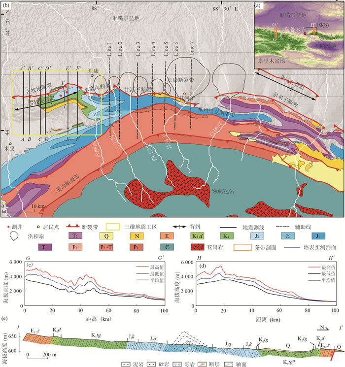
图 1 研究区地质
a. 天山山脉及周边地区地形;b. 东天山地质简图,包括三维地震数据的位置,AA'、BB'、CC'、DD'、EE'、FF'表示三维地震剖面,Line 1~7表示外推辅助线;c. 北天山地形条带剖面,具体位置见图 1a;d. 东天山地形条带剖面,具体位置见图 1a;e. 古牧地背斜野外地表实测剖面,具体位置见图 1b(改自马德龙等,2017)
Fig. 1. Geology of study area
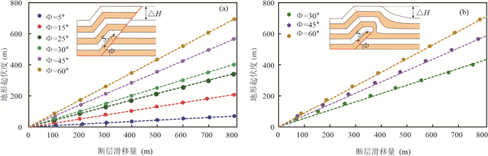
图 2 根据断层相关褶皱模拟不同断层倾角下的断层转折褶皱(a)和断层传播褶皱(b)的地形起伏度(△H)-断层滑移量(Sl)的函数关系
图中参数φ为断层倾角
Fig. 2. According to the fault related folds, the functional relationship between the topographic relief (△H) and fault slip (Sl) of fault bend fold (a) and fault propagation fold (b) with different fault dip angles
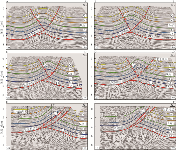
图 3 古牧地背斜三维地震资料中提取的剖面AA'~FF'的构造解译
Q. 第四系;N. 新近系;K1tg. 白垩纪吐谷鲁群;J3. 晚侏罗系;J2t. 头屯河组;J2x. 西山窑组;F1. 反冲断层;F2. 反冲断层;F3. 分支逆冲断层
Fig. 3. The interpretations of the cross sections AA'⁃FF'extracted from the 3D seismic data of the Gumudi anticline
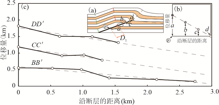
图 4 BB'、CC'、DD'剖面的位移量-距离关系图
a. 距离(D1)为沿断层下盘最低岩层底界和断层交点P向尖端d测量各岩层顶界到P的间距,每一岩层的位移量为a、b、c;b. 位移量-距离图,其中沿x轴绘制沿断层从P到d的距离,在该距离处与断层相交的每一层的位移决定了每个点的y值;c. BB'、CC'和DD'剖面的位移-距离关系图;a,b. 修改自Hughes and Shaw(2014)
Fig. 4. Displacement⁃distance relationship measured by profile BB', CC' and DD'
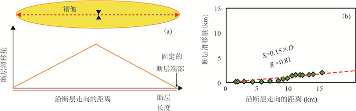
图 5 断层滑移量-沿断层走向的距离关系
a. 表示整个褶皱的断层滑移量与沿断层走向的距离的关系;b. 表示三维工区中统计的断层滑移量与沿断层走向的距离的关系
Fig. 5. Relationship between fault slip and distance along fault strike
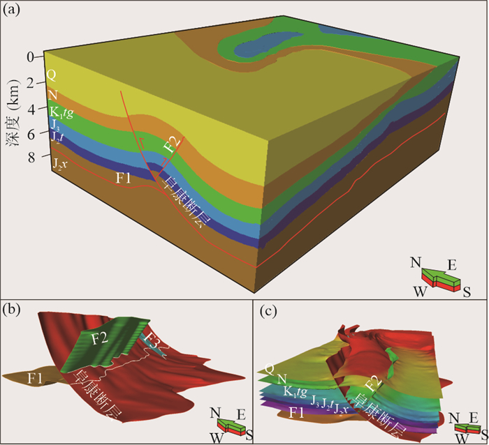
图 6 古牧地背斜模型
a. 古牧地背斜地下三维模型;b. 古牧地背斜的断层模型;c. 古牧地背斜断层与地层的几何结构关系模型;Q. 第四系;N. 新近系;K1tg. 白垩纪吐谷鲁群;J3. 晚侏罗系;J2t. 头屯河组;J2x. 西山窑组;F1. 反冲断层;F2. 反冲断层;F3. 分支逆冲断层
Fig. 6. Model of Gumudi anticline
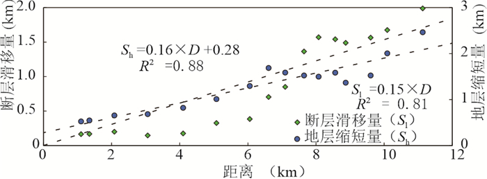
图 7 古牧地背斜的断层滑移量-距离关系和平均缩短量-距离关系
绿色菱形表示断层滑移量;蓝色圆圈表示地层平均缩短量
Fig. 7. The relationship between fault slip and distance along the strike and the relationship between mean shortening and distance along the strike of Gumudi anticline
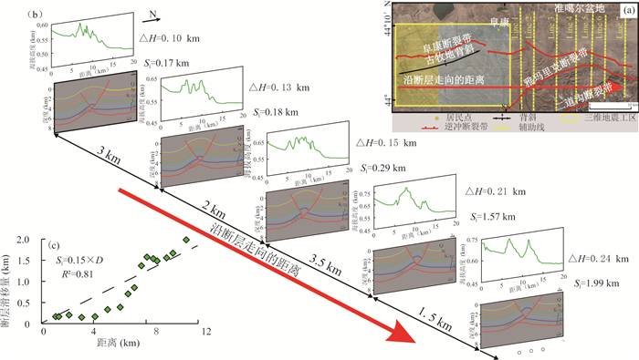
图 8 沿阜康断裂带的断层滑移量-距离关系
a. 卫星图像上地震剖面的位置;b. 断层滑移量和地形起伏度沿断层走向距离的变化;c. 断层滑移量-距离图
Fig. 8. The relationship between fault slip and distance along Fukang fault zone
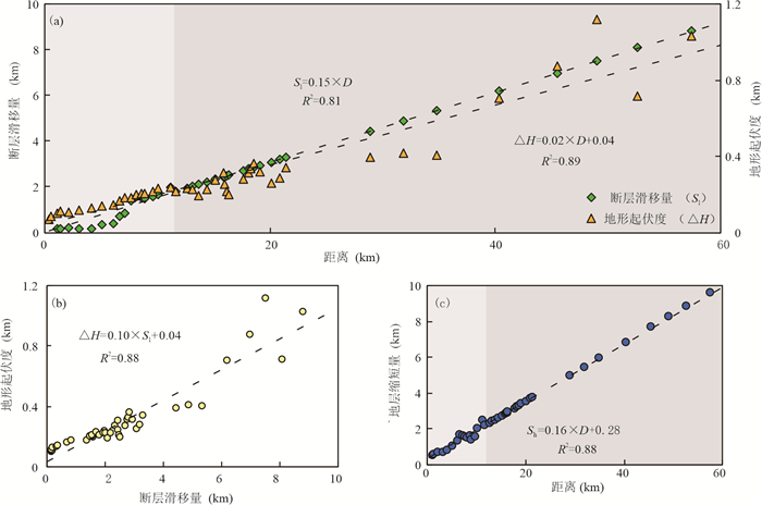
图 9 阜康断裂带关系
a. 阜康断裂带的断层滑移量与地形起伏度沿断层走向距离的关系图,绿色菱形表示断层滑移量,橙色三角形表示地形起伏度. 灰白色区域的断层滑移量由三维地震数据计算,而灰色区域的断层滑移量根据公式(2)计算获得;b. 阜康断裂带的地形起伏度与断层滑移量的关系;c. 地层平均缩短量与沿断层走向距离的关系图,灰白色区域的平均缩短量由三维地震资料计算,灰色区域的平均缩短量由公式(3)计算获得
Fig. 9. Relationship of Fukang fault
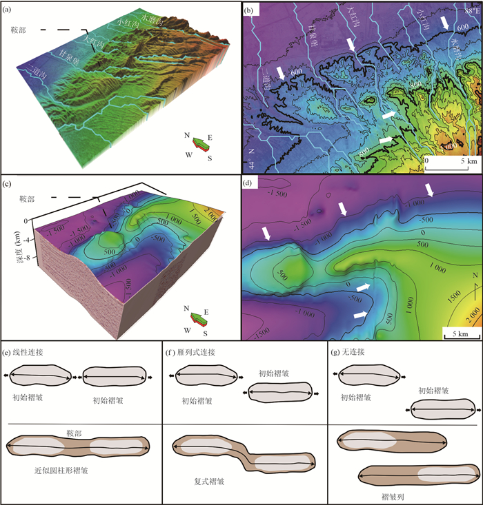
图 10 三维工区的地形和构造起伏分析
a. 三维地形;b. 二维地形;c. 三维构造起伏;d. 二维构造起伏;e. 褶皱线性连接;f. 褶皱雁列式连接;g. 褶皱无连接;褶皱发育与连接过程e、f、g引自Bretis et al.(2011)
Fig. 10. Analysis of topographic and tectonic surfaces in 3D work area
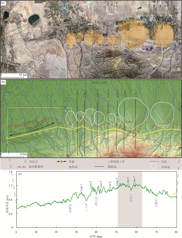
图 11 阜康断裂带现有冲积扇的分布及沿断层走向的地形剖面
a. 卫星图像洪积扇的位置图,橙色区域表示洪积扇;b. DEM显示的洪积扇位置,白色区域表示冲积扇;c. 沿断层走向AB的地形剖面,对应图 11b黄线,灰色区域表示最大洪积扇的位置和褶皱的最高点
Fig. 11. The distribution of existing alluvial fan and the terrain profile along fault strike in Fukang fault zone
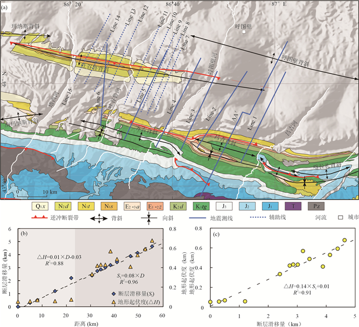
图 12 北天山吐谷鲁背斜地质与各参数关系图
a. 北天山吐谷鲁背斜简化地质地图(改自Qiu et al.,2019);b. 吐谷鲁背斜断层滑移量与地形起伏度沿断层走向距离的关系,灰白色区域的断层滑移量根据Qiu et al.(2019)数据计算获得,灰色区域的断层滑移量根据公式(6)计算获得;c. 吐谷鲁背斜地形起伏度与断层滑移量之间的关系
Fig. 12. Geological map of Tuguluanticline in the Northern Tianshan Mountains
表 1 博格达山磷灰石裂变径迹测年结果
Table 1. Apatite fission track dating results of Bogda Mountain
剥露期次 最新一次剥蚀速率 最近一次剥蚀量 文献来源 隆升阶段:
④5.6~19.0 Ma
③20~30 Ma
②42~47 Ma
① > 65 Ma- - 王宗秀等(2008) 隆升阶段:
④约10 Ma
③约40 Ma
②90~70 Ma
①155~135 Ma0.273 mm/a 2.73 km 汪新伟等(2007) 隆升阶段:
④13~9 Ma
③44~24 Ma
②75~65 Ma
①150~106 Ma0.158 mm/a 1.422~2.054 km 沈传波等(2006) 剥露阶段:
④12~7 Ma
③47~31 Ma
②67~65 Ma
①119~105 Ma0.157~0.222 mm/a 1.099~2.664 km 朱文斌等(2006) 隆升-剥露阶段:
③渐新世末-中新世初
②晚白垩世-早古近纪初
①晚侏罗世晚期-早白垩世初- 2.5~3.0 km 马庆佑(2006)  下载: 导出CSV
-
Allmendinger, R. W., 1998. Inverse and Forward Numerical Modeling of Trishear Fault-Propagation Folds. Tectonics, 17(4): 640-656. https://doi.org/10.1029/98tc01907 Avouac, J. P., Burov, E. B., 1996. Erosion as a Driving Mechanism of Intracontinental Mountain Growth. Journal of Geophysical Research: Solid Earth, 101(B8): 17747-17769. https://doi.org/10.1029/96jb01344 Avouac, J. P., Tapponnier, P., Bai, M., et al., 1993. Active Thrusting and Folding along the Northern Tien Shan and Late Cenozoic Rotation of the Tarim Relative to Dzungaria and Kazakhstan. Journal of Geophysical Research: Solid Earth, 98(B4): 6755-6804. https://doi.org/10.1029/92jb01963 Bagha, N., Arian, M., Ghorashi, M., et al., 2014. Evaluation of Relative Tectonic Activity in the Tehran Basin, Central Alborz, Northern Iran. Geomorphology, 213(5): 66-87. https://doi.org/10.1016/j.geomorph.2013.12.041 Braun, J., 2002. Quantifying the Effect of Recent Relief Changes on Age-Elevation Relationships. Earth and Planetary Science Letters, 200(3/4): 331-343. https://doi.org/10.1016/s0012-821x(02)00638-6 Bretis, B., Bartl, N., Grasemann, B., 2011. Lateral Fold Growth and Linkage in the Zagros Fold and Thrust Belt (Kurdistan, NE Iraq). Basin Research, 23(6): 615-630. https://doi.org/10.1111/j.1365-2117.2011.00506.x Brozovi, N., Burbank, D. W., Meigs, J.A., et al., 1997. Climatic Limits on Landscape Development in the Northwestern Himalaya. Science, 276(5312): 571-574. https://doi.org/10.1126/science.276.5312.571 Burchfiel, B. C., Brown, E. T., Deng, Q. D., et al., 1999. Crustal Shortening on the Margins of the Tien Shan, Xinjiang, China. International Geology Review, 41(8): 665-700. https://doi.org/10.1080/00206819909465164 Champagnac, J. D., Molnar, P., Sue, C., et al., 2012. Tectonics, Climate, and Mountain Topography. Journal of Geophysical Research: Solid Earth, 117(B2): B02403. https://doi.org/10.1029/2011jb008348 Chapple, W. M., 1978. Mechanics of Thin-Skinned Fold-and-Thrust Belts. Geological Society of America Bulletin, 89(8): 1189-1198. https://doi.org/10.1130/0016-7606(1978)89<1189:MOTFB>2.0.CO;2 doi: 10.1130/0016-7606(1978)89<1189:MOTFB>2.0.CO;2 Davis, D., Suppe, J., Dahlen, F. A., 1983. Mechanics of Fold-and-Thrust Belts and Accretionary Wedges. Journal of Geophysical Research, 88(B2): 1153. https://doi.org/10.1029/jb088ib02p01153 Deng, Q.D., Feng, X.Y., Zhang, P.Z., et al., 2000. Active Structure of Tianshan Mountains. Seismological Press, Beijing (in Chinese). Dielforder, A., Hetzel, R., Oncken, O., 2020. Megathrust Shear Force Controls Mountain Height at Convergent Plate Margins. Nature, 582(7811): 225-229. https://doi.org/10.1038/s41586-020-2340-7 Egholm, D. L., Nielsen, S. B., Pedersen, V. K., et al., 2009. Glacial Effects Limiting Mountain Height. Nature, 460(7257): 884-887. https://doi.org/10.1038/nature08263 England, P., Molnar, P., 1990. Surface Uplift, Uplift of Rocks, and Exhumation of Rocks. Geology, 18(12): 1173. https://doi.org/10.1130/0091-7613(1990)018<1173:suuora>2.3.co;2 doi: 10.1130/0091-7613(1990)018<1173:suuora>2.3.co;2 Erslev, E. A., 1991. Trishear Fault-Propagation Folding. Geology, 19(6): 617. https://doi.org/10.1130/0091-7613(1991)019<0617:tfpf>2.3.co;2 doi: 10.1130/0091-7613(1991)019<0617:tfpf>2.3.co;2 Fu, B. H., Lin, A. M., Kano, K. I., et al., 2003. Quaternary Folding of the Eastern Tian Shan, Northwest China. Tectonophysics, 369(1/2): 79-101. https://doi.org/10.1016/s0040-1951(03)00137-9 Gao, Z. B., Tian, W., Wang, L., et al., 2017. Emplacement of Intrusions of the Tarim Flood Basalt Province and their Impacts on Oil and Gas Reservoirs: A 3D Seismic Reflection Study in Yingmaili Fields, Tarim Basin, Northwest China. Interpretation, 5(3): SK51-SK63. https://doi.org/10.1190/int-2016-0165.1 Grasemann, B., Schmalholz, S. M., 2012. Lateral Fold Growth and Fold Linkage. Geology, 40(11): 1039-1042. https://doi.org/10.1130/g33613.1 Hardy, S., Poblet, J., 2005. A Method for Relating Fault Geometry, Slip Rate and Uplift Data above Fault-Propagation Folds. Basin Research, 17(3): 417-424. https://doi.org/10.1111/j.1365-2117.2005.00268.x He, C. Q., Yang, C. J., Turowski, J. M., et al., 2021. Constraining Tectonic Uplift and Advection from the Main Drainage Divide of a Mountain Belt. Nature Communications, 12(1): 1-10. https://doi.org/10.1038/s41467-020-20748-2 Hendrix, M. S., Dumitru, T. A., Graham, S. A., 1994. Late Oligocene-Early Miocene Unroofing in the Chinese Tian Shan: An Early Effect of the India-Asia Collision. Geology, 22(6): 487. https://doi.org/10.1130/0091-7613(1994)022<0487:loemui>2.3.co;2 doi: 10.1130/0091-7613(1994)022<0487:loemui>2.3.co;2 Hubbard, J., Shaw, J. H., 2009. Uplift of the Longmen Shan and Tibetan Plateau, and the 2008 Wenchuan (M=7.9) Earthquake. Nature, 458(7235): 194-197. https://doi.org/10.1038/nature07837 Hubbard, J., Shaw, J. H., Klinger, Y., 2010. Structural Setting of the 2008 Mw 7.9 Wenchuan, China, Earthquake. Bulletin of the Seismological Society of America, 100(5B): 2713-2735. https://doi.org/10.1785/0120090341 Hughes, A. N., Shaw, J. H., 2014. Fault Displacement-Distance Relationships as Indicators of Contractional Fault-Related Folding Style. AAPG Bulletin, 98(2): 227-251. https://doi.org/10.1306/05311312006 Hughes, A. N., Shaw, J. H., 2015. Insights into the Mechanics of Fault-Propagation Folding Styles. Geological Society of America Bulletin, 127(11/12): 1752-1765. https://doi.org/10.1130/b31215.1 Kirby, E., Whipple, K. X., Tang, W. Q., et al., 2003. Distribution of Active Rock Uplift along the Eastern Margin of the Tibetan Plateau: Inferences from Bedrock Channel Longitudinal Profiles. Journal of Geophysical Research: Solid Earth, 108(B4): 2217. https://doi.org/10.1029/2001jb000861 Kirkpatrick, J. D., Edwards, J. H., Verdecchia, A., et al., 2020. Subduction Megathrust Heterogeneity Characterized from 3D Seismic Data. Nature Geoscience, 13(5): 369-374. https://doi.org/10.1038/s41561-020-0562-9 Lamb, S., 2006. Shear Stresses on Megathrusts: Implications for Mountain Building Behind Subduction Zones. Journal of Geophysical Research, 111(B7): B07401. https://doi.org/10.1029/2005jb003916 Lee, W. H., Wu, F., Jacobsen, C., 1976. A Catalog of Historical Earthquakes in China Compiled from Recent Chinese Publications. Bulletin of the Seismological Society of America, 66(6): 2003-2016. doi: 10.1785/BSSA0660062003 Li, G.W., 2021. A Brief Review of Several Issues on Tectonic Geomorphology and Low Temperature Thermochronology Applications. Acta Geologica Sinica, 95(1): 214-226 (in Chinese with English abstract). Li, J.Y., Wang, K.Z., Li, Y.P., et al., 2006. Geomorphological Features, Crustal Composition and Geological Evolution of the Tianshan Mountains. Geological Bulletin of China, 25(8): 895-909 (in Chinese with English abstract). Li, X.Y., Liu, L.J., Chen, W., 2004. Analysis of Structural Model of Gumudi Anticline in Southern Margin of Junggar Basin. Xinjiang Petroleum Geology, 25(02): 141-142 (in Chinese with English abstract). http://en.cnki.com.cn/Article_en/CJFDTOTAL-XJSD200402007.htm Li, Y. Q., Wei, D. T., Chen, Z. X., et al., 2016. Multiphase Deformation Deduced from 3D Construction and Restoration: Implication for the Hydrocarbon Exploration in the Mountain Front of the Northern Tianshan. Marine and Petroleum Geology, 77(B4): 916-930. https://doi.org/10.1016/j.marpetgeo.2016.07.028 Li, Y. Q., Wei, D. T., Tian, H., et al., 2018. The 3-D Structural Model of an Out-of-Sequence Earthquake in China: Implication for the Reactivation of Positive Inversion Structures along the Northern Tianshan Fold-and-Thrust Belt. Tectonics, 37(12): 4359-4376. https://doi.org/10.1029/2018tc005075 Liu, L.J., Chen, W., 2002. Geometric and Kinematic Characteristics of Thick and Thin Skin Nappe Structures in the Piedmont of the Northern Tianshan Mountains. Natural Gas Industry, 22(5): 104-105 (in Chinese). http://qikan.cqvip.com/Qikan/Article/Detail?id=6856810 Lu, H. H., Li, B. J., Wu, D. Y., et al., 2019. Spatiotemporal Patterns of the Late Quaternary Deformation Across the Northern Chinese Tian Shan Foreland. Earth-Science Reviews, 194(2): 19-37. https://doi.org/10.1016/j.earscirev.2019.04.026 Lu, H. H., Wu, D. Y., Cheng, L., et al., 2017. Late Quaternary Drainage Evolution in Response to Fold Growth in the Northern Chinese Tian Shan Foreland. Geomorphology, 299(2): 12-23. https://doi.org/10.1016/j.geomorph.2017.09.037 Lü, H.H., Wang, W., Chang, Y., et al., 2013. Cenozoic Episodic Exhumation of the Tian Shan Range, NW China. Quaternary Sciences, 33(4): 812-822 (in Chinese with English abstract). Ma, D.L., He, D.F., Wei, D.T., et al., 2017. Multiple Phase Deformation of Gumudi Anticline at South Margin of Junggar Basin. Journal of Jilin University (Earth Science Edition), 47(6): 1695-1704 (in Chinese with English abstract). http://www.researchgate.net/publication/322919764_Multiple_Phase_Deformation_of_Gumudi_Anticline_at_South_Margin_of_Junggar_Basin Ma, Q.Y., 2006. The Tectonic Charaeteristics of Bogeda Mountain and Its Orogeny at Mesozoie-Cenozoic Time(Dissertation). China University of Geoscienees (Beijing), Beijing (in Chinese with English abstract). Martinez, J., Cartwright, J., Hall, B., 2005.3D Seismic Interpretation of Slump Complexes: Examples from the Continental Margin of Israel. Basin Research, 17(1): 83-108. https://doi.org/10.1111/j.1365-2117.2005.00255.x Molnar, P., England, P., 1990. Late Cenozoic Uplift of Mountain Ranges and Global Climate Change: Chicken or Egg? Nature, 346(6279): 29-34. https://doi.org/10.1038/346029a0 Molnar, P., Tapponnier, P., 1975. Cenozoic Tectonics of Asia: Effects of a Continental Collision: Features of Recent Continental Tectonics in Asia can be Interpreted as Results of the India-Eurasia Collision. Science, 189(4201): 419-426. https://doi.org/10.1126/science.189.4201.419 Oyedele, K., Ogagarue, D., Mohammed, D., 2013. Integration of 3D Seismic and Well Log Data in the Optimal Reservoir Characterisation of EMI Field, Offshore Niger Delta Oil Province, Nigeria. American Journal of Scientific and Industrial Research, 4(1): 11-21. https://doi.org/10.5251/ajsir.2013.4.1.11.21 Qiu, J. H., Rao, G., Wang, X., et al., 2019. Effects of Fault Slip Distribution on the Geometry and Kinematics of the Southern Junggar Fold-and-Thrust Belt, Northern Tian Shan. Tectonophysics, 772(7-8): 228209. https://doi.org/10.1016/j.tecto.2019.228209 Reiners, P. W., Brandon, M. T., 2006. Using Thermochronology to Understand Orogenic Erosion. Annual Review of Earth and Planetary Sciences, 34(1): 419-466. https://doi.org/10.1146/annurev.earth.34.031405.125202 Shang, L., Dai, J.S., Feng, J.W., et al., 2013. Geometric and Kinematic Analyses of Gumudi Anticline in Southern Margin of Junggar Basin. Xinjiang Petroleum Geology, 34(6): 627-631+617 (in Chinese with English abstract). http://en.cnki.com.cn/Article_en/CJFDTOTAL-XJSD201306004.htm Shaw, J. H., Connors, C. D., Suppe, J., 2005. Seismic Interpretation of Contractional Fault-Related Folds: An AAPG Seismic Atlas, American Association of Petroleum Geologists Tulsa, Oklahoma, U.S.A. Shaw, J. H., Novoa, E., Connors, C. D., 2004. Structural Controls on Growth Stratigraphy in Contractional Fault-Related Folds. AAPG MEMOIR, 82: 400-412. http://www.osti.gov/cgi-bin/eprints/redirectEprintsUrl?http%3A%2F%2Fgeology.wlu.edu%2Fconnors%2Fpublications%2FShaw_AAPG_Mem82.PDF Shen, C.B., Mei, L.F., Liu, L., et al., 2006. Evidence from Apatite and Zircon Fission Track Analysis for Mesozoic-Cenozoic Uplift Thermal History of Bogda Mountain of Xinjiang, Northwest China. Marine Geology & Quaternary Geology, 26(3): 87-92 (in Chinese with English abstract). http://www.researchgate.net/publication/284072548_Evidence_from_apatite_and_zircon_fission_track_analysis_for_Mesozoic-Cenozoic_uplift_thermal_history_of_Bogda_Mountain_of_Xinjiang_northwest_China Suppe, J., 1983. Geometry and Kinematics of Fault-Bend Folding. American Journal of Science, 283(7): 684-721. https://doi.org/10.2475/ajs.283.7.684 Suppe, J., 1990. Geometry and Kinematics of Fault-Bend Folding. American Journal of Science, 283(7): 684-721. https://doi.org/10.2475/ajs.283.7.684 Wang, G.C., Shen, T.Y., Chen, C., et al., 2020. Basin-Range Coupling and Tectonic Topography Analysis during Geological Mapping on Covered Area: A Case Study of Turpan-Hami Basin, Eastern Tianshan. Earth Science, 45(12): 4313-4331 (in Chinese with English abstract). Wang, T., Huang, H., Song, P., et al., 2020. Studies of Crustal Growth and Deep Lithospheric Architecture and New Issues: Exemplified by the Central Asian Orogenic Belt (Northern Xinjiang). Earth Science, 45(7): 2326-2344 (in Chinese with English abstract). Wang, X.W., Wang, X.W., Ma, Y.S., 2007. Differential Exhumation History of Bogda Mountain, Xinjiang, Northwestern China Since the Late Mesozoic. Acta Geologica Sinica, 81(11): 1507-1517 (in Chinese with English abstract). Wang, Z.X., Li, T., Zhang, J., et al., 2008. The Uplifting Proces of the Bogda Mountain during the Cenozoic and Its Tectonic Implication. Science in China (Series D), 38(3): 312-326 (in Chinese). http://qikan.cqvip.com/Qikan/Article/Detail?id=4000159026 Whipple, K. X., 2009. The Influence of Climate on the Tectonic Evolution of Mountain Belts. Nature Geoscience, 2(2): 97-104. https://doi.org/10.1038/ngeo413 Whipple, K. X., 2014. Can Erosion Drive Tectonics? Science, 346(6212): 918-919. https://doi.org/10.1126/science.aaa0887 Whipple, K. X., Kirby, E., Brocklehurst, S. H., 1999. Geomorphic Limits to Climate-Induced Increases in Topographic Relief. Nature, 401(6748): 39-43. https://doi.org/10.1038/43375 Whipple, K. X., Meade, B. J., 2004. Controls on the Strength of Coupling among Climate, Erosion, and Deformation in Two-Sided, Frictional Orogenic Wedges at Steady State. Journal of Geophysical Research: Earth Surface, 109(F1): 11. https://doi.org/10.1029/2003jf000019 Willett, S. D., 1999. Orogeny and Orography: The Effects of Erosion on the Structure of Mountain Belts. Journal of Geophysical Research: Solid Earth, 104(B12): 28957-28981. https://doi.org/10.1029/1999jb900248 Willett, S. D., 2006. Tectonics, Climate, and Landscape Evolution. Special Paper of the Geological Society of America, New York. Willett, S. D., Slingerland, R., Hovius, N., 2001. Uplift, Shortening, and Steady State Topography in Active Mountain Belts. American Journal of Science, 301(4/5): 455-485. https://doi.org/10.2475/ajs.301.4-5.455 Wu, C. Y., Wu, G. D., Shen, J., et al., 2016. Late Quaternary Tectonic Activity and Crustal Shortening Rate of the Bogda Mountain Area, Eastern Tian Shan, China. Journal of Asian Earth Sciences, 119(6608): 20-29. https://doi.org/10.1016/j.jseaes.2016.01.001 Wu, C.Y., Chen, J.B., Shen, J., et al., 2014. Late-Quaternary Activity Characteristics of the Ganhezi Segment of the Fukang Fault Belt, in Xinjiang. Earth Science, 22(3): 632-640 (in Chinese with English abstract). Wu, C.Y., Shen, J., Shi, J., et al., 2010. Late-Quaternary Activity of the Gumudi Fault of the South Fukang Fault Belt on the North Margin of the Bogda Mountains in the Xinjiang Automonous Region. Quaternary Sciences, 30(5): 1020-1029 (in Chinese with English abstract). http://en.cnki.com.cn/Article_en/CJFDTotal-DSJJ201005023.htm Xiang, Z.Y., Shen, J., Li, J., et al., 2009. Characteristics and Latest Activity Age Issue of Yamalike Fault in Urumqi. Inland Earthquake, 23(2): 215-225 (in Chinese with English abstract). http://en.cnki.com.cn/Article_en/CJFDTOTAL-LLDZ200902015.htm Yang, R., 2017. A Brief Review of Several Model of Topographic Evolution. Seismology and Geology, 39(6): 1173-1184 (in Chinese with English abstract). http://www.researchgate.net/publication/327514363_A_brief_review_of_several_models_of_topographic_evolution Yang, S.M., Li, J., Wang, Q., 2008. GPS Study of Current Deformation and Fault Activity in Tianshan Mountains. Science in China (Series D), 38(7): 872-880 (in Chinese). http://gji.oxfordjournals.org/external-ref?access_num=10.1007/s11430-008-0090-8&link_type=DOI Yin, G.H., 1993. Neotectonic Movement and Earthquakes in Ili Depression Basin. Inland Earthquake, 7(2): 180-187 (in Chinese with English abstract). http://en.cnki.com.cn/Article_en/CJFDTOTAL-LLDZ199302013.htm You, H.C., Ren, L.S., Chen, G.X., et al., 2002. Activity Forms and Slip Rates of Fukang Fault. Earthquake Research in China, 18(3): 239-248 (in Chinese with English abstract). http://epub.cnki.net/grid2008/docdown/docdownload.aspx?filename=ZGZD200203002&dbcode=CJFD&year=2002&dflag=pdfdown Yuan, Q.D., Guo, Z.J., Zhang, Z.C., et al., 2006. The Late Cenozoic Deformation of Terraces on the North Flank of Tianshan Mt. and the Tectonic Evolution. Acta Geologica Sinica, 80(2): 210-216 (in Chinese with English abstract). http://www.researchgate.net/publication/291851940_The_late_Cenozoic_deformation_of_terraces_on_the_north_flank_of_Tianshan_Mt_and_the_tectonic_evolution Zhang, P.Z., Deng, Q.D., Xu, X.W., et al., 1994. Blind Thrust, Folding Earthquake, and the 1906 Manas Earthquake, Xinjiang. Seismology and Geology, 16(3): 193-204 (in Chinese with English abstract). Zhang, P.Z., Wang, Q., Ma, Z.J., 2002. GPS Velocity Field and Active Crustal Blocks of Contemporary Tectonic Deformation Continental China. Earth Science Frontiers, 9(2): 430-441 (in Chinese). Zhou, Y. X., Wu, C. D., Yuan, B., et al., 2020. Cenozoic Tectonic Patterns and their Controls on Growth Strata in the Northern Tianshan Fold and Thrust Belt, Northwest China. Journal of Asian Earth Sciences, 198(4): 104237. https://doi.org/10.1016/j.jseaes.2020.104237 Zhu, W.B., Shu, L.S., Wan, J.L., et al., 2006. Fission-Track Evidence for the Exhumation History of Bogda-Harlik Mountains, Xinjiang Since the Cretaceous. Acta Geologica Sinica, 80(1): 16-22 (in Chinese with English abstract). 邓起东, 冯先岳, 张培震, 等, 2000. 天山活动构造, 北京: 地震出版社. 李锦轶, 王克卓, 李亚萍, 等, 2006. 天山山脉地貌特征、地壳组成与地质演化. 地质通报, 25(8): 895-909. doi: 10.3969/j.issn.1671-2552.2006.08.001 李广伟, 2021. 构造地貌与低温热年代学若干问题探讨. 地质学报, 95(1): 214-226. https://www.cnki.com.cn/Article/CJFDTOTAL-DZXE202101015.htm 李学义, 刘楼军, 陈伟, 2004. 准噶尔盆地南缘古牧地构造建模分析. 新疆石油地质, 25(2): 141-142. doi: 10.3969/j.issn.1001-3873.2004.02.008 刘楼军, 陈伟, 2002. 北天山山前带厚皮与薄皮推覆构造的几何学运动学特征. 天然气工业, 22(5): 104-105. doi: 10.3321/j.issn:1000-0976.2002.05.031 吕红华, 王玮, 常远, 等, 2013. 新疆天山造山带新生代多期次剥露作用过程. 第四纪研究, 33(4): 812-822. doi: 10.3969/j.issn.1001-7410.2013.04.17 马德龙, 何登发, 魏东涛, 等, 2017. 准噶尔盆地南缘古牧地背斜多期构造变形特征. 吉林大学学报(地球科学版), 47(6): 1695-1704. https://www.cnki.com.cn/Article/CJFDTOTAL-CCDZ201706009.htm 马庆佑, 2006. 新疆博格达山的构造特征与中-新生代的造山活动(博士毕业论文). 北京: 中国地质大学(北京). 商琳, 戴俊生, 冯建伟, 等, 2013. 准噶尔盆地南缘古牧地背斜几何学与运动学分析. 新疆石油地质, 34(6): 627-631+617. https://www.cnki.com.cn/Article/CJFDTOTAL-XJSD201306004.htm 沈传波, 梅廉夫, 刘麟, 等, 2006. 新疆博格达山中新生代隆升-热历史的裂变径迹记录. 海洋地质与第四纪地质, 26(3): 87-92. https://www.cnki.com.cn/Article/CJFDTOTAL-HYDZ200603013.htm 汪新伟, 汪新文, 马永生, 2007. 新疆博格达山晚中生代以来的差异剥露史. 地质学报, 81(11): 1507-1517. doi: 10.3321/j.issn:0001-5717.2007.11.005 王宗秀, 李涛, 张进, 等, 2008. 博格达山链新生代抬升过程及意义. 中国科学: 地球科学, 38(3): 312-326. doi: 10.3321/j.issn:1006-9267.2008.03.005 王国灿, 申添毅, 陈超, 等, 2020. 覆盖区地质调查中的盆山构造地貌关系研究: 以东天山-吐哈盆地为例. 地球科学, 45(12): 4313-4331. https://www.cnki.com.cn/Article/CJFDTOTAL-DQKX202012004.htm 王涛, 黄河, 宋鹏, 等, 2020. 地壳生长及深部物质架构研究与问题: 以中亚造山带(北疆地区)为例. 地球科学, 45(7): 2326-2344. https://www.cnki.com.cn/Article/CJFDTOTAL-DQKX202007010.htm 吴传勇, 陈建波, 沈军, 等, 2014. 新疆阜康断裂带甘河子段晚第四纪活动特征. 地球科学, 22(3): 632-640. https://www.cnki.com.cn/Article/CJFDTOTAL-DQKX201303023.htm 吴传勇, 沈军, 史杰, 等, 2010. 新疆博格达山北缘阜康南断裂带古牧地段晚第四纪活动特征. 第四纪研究, 30(5): 1020-1029. doi: 10.3969/j.issn.1001-7410.2010.05.20 向志勇, 沈军, 李军, 等, 2009. 乌鲁木齐市雅玛里克断裂特征与最新活动时代问题. 内陆地震, 23(2): 215-225. doi: 10.3969/j.issn.1001-8956.2009.02.016 杨蓉, 2017. 几种地形演化的数值模拟模型简述. 地震地质, 39(6): 1173-1184. doi: 10.3969/j.issn.0253-4967.2017.06.006 杨少敏, 李杰, 王琪, 2008. GPS研究天山现今变形与断层活动. 中国科学D辑: 地球科学, 38(7): 872-880. doi: 10.3321/j.issn:1006-9267.2008.07.009 尹光华, 1993. 伊犁盆地新构造运动与地震. 内陆地震, 7(2): 180-187. https://www.cnki.com.cn/Article/CJFDTOTAL-LLDZ199302013.htm 尤惠川, 任利生, 陈国星, 等, 2002. 东天山阜康断裂的变形方式与全新世滑动速率. 中国地震, 18(3): 239-248. doi: 10.3969/j.issn.1001-4683.2002.03.003 袁庆东, 郭召杰, 张志诚, 等, 2006. 天山北缘河流阶地形成及构造变形定量分析. 地质学报, 80(2): 210-216. https://www.cnki.com.cn/Article/CJFDTOTAL-DZXE200602006.htm 张培震, 邓起东, 徐锡伟, 等, 1994. 盲断裂, 褶皱地震与新疆1906年玛纳斯地震. 地震地质, 16(3): 193-204. https://www.cnki.com.cn/Article/CJFDTOTAL-DZDZ403.000.htm 张培震, 王琪, 马宗晋, 2002. 中国大陆现今构造运动的GPS速度场与活动地块. 地学前缘, 9(2): 430-441. doi: 10.3321/j.issn:1005-2321.2002.02.022 朱文斌, 舒良树, 万景林, 等, 2006. 新疆博格达——哈尔里克山白垩纪以来剥露历史的裂变径迹证据. 地质学报, 80(1): 16-22. doi: 10.3321/j.issn:0001-5717.2006.01.002 -

 点击查看大图
计量
- 文章访问数: 1216
- HTML全文浏览量: 783
- PDF下载量: 124
- 被引次数: 0
