


Sedimentary-Reservoir Characteristics under Control of Transfer Model and Implications for Hydrocarbon Exploration in Huizhou Depression, Pearl River Mouth Basin
-
摘要: 构造转换带以其重要石油地质意义而受到学者们的广泛关注,尤其强调转换斜坡对大型砂体展布方向及堆积范围的控制.针对转换带及附近陡坡带的砂体及优质储层分布规律的复杂性,以惠州凹陷西南缘为例提出一种基于"转换体"概念的转换体优质砂体预测方法.相比于转换带,转换体研究变"带"为"体",是对转换带的扩充和深入.研究范围上,将转换斜坡带与断控陡坡纳为组合体,强调两者在三维立体组合下沉积体存在动态时空交互作用;研究内容上,以"构造-地貌-沉积-储层"思路来分析优质砂体的成因及演化.基于"转换体"的优质砂体预测方法,指出惠州26洼西南缘可划分出"锐角-直角-钝角"三类转换体模型,在不同类型转换体的构造-地貌格局下,陡坡和转换斜坡扇体间具有孤立-叠加-联控三类控沉效应,其对应储层物性逐渐变好.系统解析惠州凹陷转换体控沉-控储特性对完善转换体系框架有理论意义,同时可服务大中型油气田的勘探需求.Abstract: Structural transfer zone has been widely concerned by scholars for its important petroleum geological significance, especially the control of the transfer slope on the distribution direction and accumulation range of large sand bodies. In view of the complexity of the distribution of sand bodies and high-quality reservoirs in the transfer zone and nearby steep slope zone, taking the southwest edge of Huizhou depression as an example, a prediction method of high-quality sand bodies in the transfer zone based on the concept of "transfer model" is proposed. Compared with the transfer zone, the study of transfer model is an extension and deepening of the transfer zone studies. In the research scope, the transfer slope zone and fault controlled steep slope are regarded as the combination, emphasizing that there is dynamic space-time interaction between the two sedimentary bodies under the three-dimensional combination. In the research content, the genesis and evolution of high-quality sand bodies are analyzed with the idea of "structure-landform-sedimentation-reservoir", so as to have stronger petroleum geological significance. Based on the concept of "transfer model", in this paper it proposes that three types of transfer models of "acute angle-right angle-obtuse angle" can be divided in the southwest of Huizhou 26 sag. In the structure-geomorphic framework of different types of transfer models, there are three types of sedimentation control effects between the steep slope and the transfer slope fan, which are isolation-superimposition-joint control, and their reservoir physical properties gradually become better. Systematic analysis of sedimentary-reservoir characteristics of transfer model in the Huizhou depression is of theoretical significance to improve the transformation system framework, and it can also meet the exploration demands of large and medium-sized oil and gas reservoirs.
-

图 1 转换带水系演化模式(Athmer and Luthi, 2011)
Fig. 1. Evolution model of the transfer belt drainage system (Athmer and Luthi, 2011)
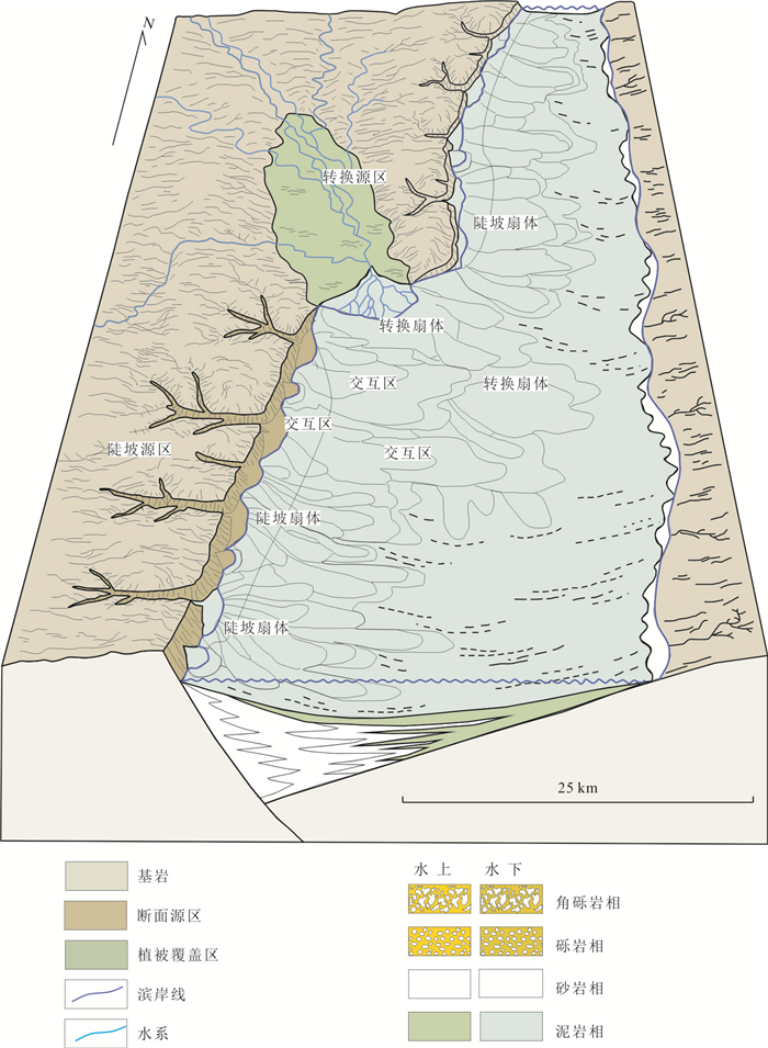
图 2 转换带与陡坡带交互模式图(修改自Henstra et al., 2016)
Fig. 2. Dynamic space-time interaction of the transfer slope zone and fault controlled steep slope zone (modified from Henstra et al., 2016)
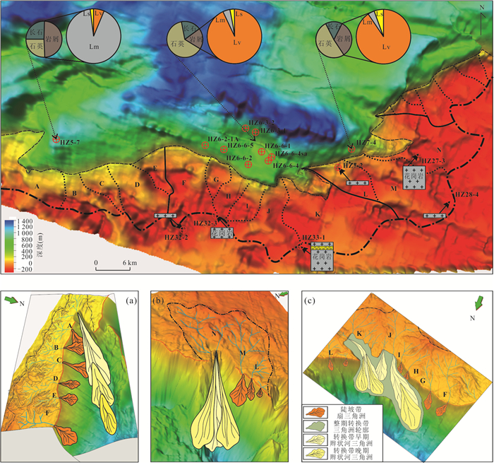
图 3 惠州凹陷西南地区源‒汇单元及转换体类型图
a.锐角‒叠加型;b.直角‒孤立型;c.钝角‒潜山联控型
Fig. 3. Source-to-sink units and transfer model types in the southwest of Huizhou depression
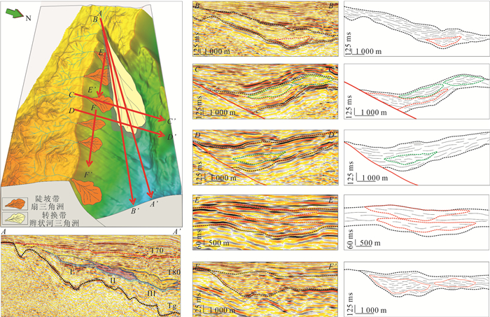
图 4 惠州凹陷西南地区锐角‒叠加型转换体地震构型特征
Fig. 4. Seismic architecture characteristics of the acute angle-superposition transfer model in the southwest of Huizhou depression
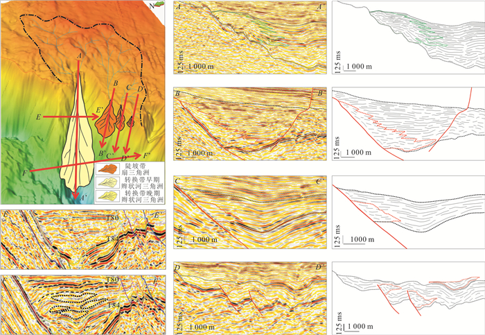
图 5 惠州凹陷西南地区直角‒孤立型转换体地震构型特征
Fig. 5. Seismic architecture characteristics of the right-to-isolated transfer model in the southwest of Huizhou depression

图 6 惠州凹陷西南地区钝角‒潜山联控型转换体地震构型特征
Fig. 6. Seismic architecture characteristics of the obtuse angle-buried hill combined transfer model in the southwest of Huizhou depression
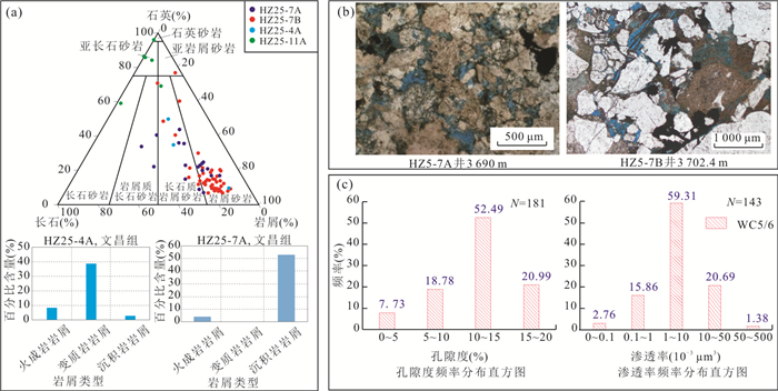
图 7 锐角‒叠加型转换体储层特征
Fig. 7. Reservoir characteristics of the acute angle-superposition transfer model
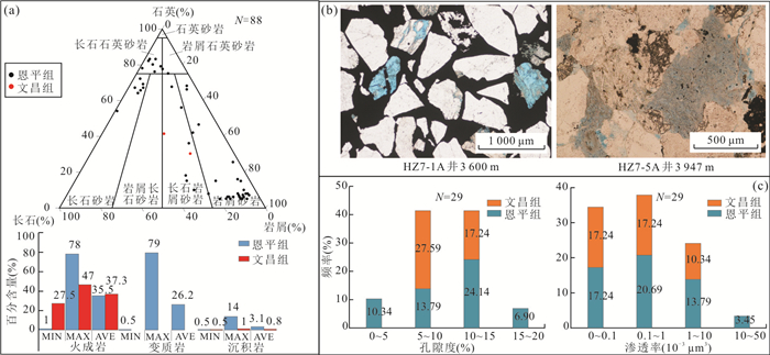
图 8 直角‒孤立型转换体储层特征
Fig. 8. Reservoir characteristics of the right-to-isolated transfer model
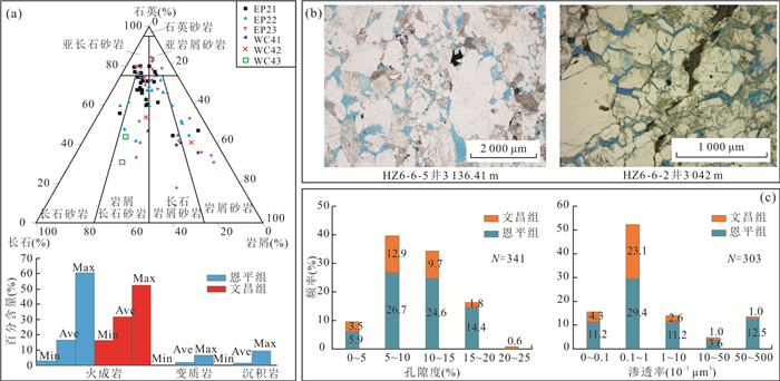
图 9 钝角‒潜山联控型转换体储层特征
Fig. 9. Reservoir characteristics of the obtuse angle-buried hill combined transfer model
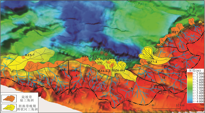
图 10 惠西南地区古近系文昌期不同类型转换体“源‒汇”耦合模式
Fig. 10. Source-to-sink coupling pattern of different types of transfer models in the Wenchang period of the Paleogene in the southwest of Huizhou depression
表 1 惠州凹陷西南地区锐角‒叠加型转换体“源‒汇”参数统计
Table 1. Source-to-sink parametric statistics of the acute angle-superposition transfer model in the southwest of Huizhou depression
源 源汇单元 A B C D E 基岩性质 花岗岩 汇水面积(km2)-Tg 104 27 18 43 24 集水高差(ms)-Tg 180 250 160 210 230 渠 沟谷编号 V1 V2 V3 V4 V5 V6 V7 沟谷形态 V/U V/U V V W U U 宽度(m) 1 662.50 4 010.00 123.75 3 051.25 3 555.00 1 100.00 2 761.25 深度(m) 182.23 423.87 54.12 291.83 124.68 79.43 171.87 宽深比 9.12 9.46 2.29 10.46 28.51 13.85 16.07 边 边界样式 转换斜坡 断裂陡坡 断裂角度(°) 先陡后缓21.8~8.4 21.6 22.5 24.8 27.1 相带类型 辫状河三角洲 扇三角洲 扇三角洲 扇三角洲 扇三角洲 汇 展布形态 帚状 扇裙状 扇状 扇状 面积(km2) 41.95 10.19 4.50 3.54 2.83 厚度(km) 0.53 0.30 0.23 0.33 0.69 体积(km3) 11.09 1.51 0.53 0.58 0.98  下载: 导出CSV
表 2 惠州凹陷西南地区直角‒孤立型转换体“源‒汇”参数统计
Table 2. Source-to-sink parametric statistics of the right-to-isolated transfer model in the southwest of Huizhou depression
源 源汇单元 L M N 基岩性质 花岗岩 汇水面积(km2) 28 79 97 集水高差(ms)-Tg 200 215 240 渠 沟谷编号 V17 V18 V19 V20 沟谷形态 V U 断槽 宽度(m) 2 352.77 1 881.93 2 785.21 2 634.42 深度(m) 294.97 218.83 395.91 381.55 宽深比 7.98 8.60 7.04 6.90 边 边界样式 断裂陡坡 转换斜坡 断裂角度(°) 29.5 32.9 先缓后陡12.3~25.4 相带类型 扇三角洲 扇三角洲 扇辫叠置 汇 展布形态 扇状 扇状 朵状 面积(km2) 2.93 3.79 20.28 厚度(km) 0.56 0.60 0.66 体积(km3) 0.82 1.14 6.71
下载: 导出CSV
表 3 惠西南地区钝角‒潜山联控转换体“源‒汇”参数统计
Table 3. Source-to-sink parametric statistics of the obtuse angle-buried hill combined transfer model in the southwest of Huizhou depression
源 源汇单元 F G H I J K 基岩性质 花岗岩 汇水面积(km2) 61 15 19 18 52 109 集水高差(ms)-Tg 200 190 180 185 175 180 渠 沟谷编号 V9 V10 V11 V12 V13 V14 V15 V16 沟谷形态 V V V V V V V/U V/U 宽度(m) 893.72 1 058.10 1 368.45 1 406.24 1 137.46 1 824.75 1 674.54 1 900.43 深度(m) 83.65 98.68 145.20 133.29 127.98 103.86 332.67 356.34 宽深比 10.68 10.72 9.42 10.55 8.89 17.57 5.03 5.33 边 边界样式 断裂陡坡 转换斜坡 转换斜坡 断裂角度(°) 35.8 38.6 27.5 21.8 先陡后缓21.8~8.4 先缓后陡15.4~40 相带类型 扇三角洲 扇三角洲 扇三角洲 扇三角洲 扇三角洲 扇三角洲 汇 展布形态 扇状 扇状 扇/裙边 扇/裙边 帚状 朵状 面积(km2) 11.47 3.00 4.30 0.85 45.02 19.31 厚度(km) 0.97 0.77 0.64 0.51 0.77 0.85 体积(km3) 5.56 1.02 1.16 0.22 13.96 8.19
下载: 导出CSV
-
Athmer, W., Luthi, S. M., 2011. The Effect of Relay Ramps on Sediment Routes and Deposition: A Review. Sedimentary Geology, 242(1-4) : 1-17. doi: 10.1016/j.sedgeo.2011.10.002 Dahlstrom, C.D.A., 1970. Structural Geology in the Eastern Margin of the Canadian Rocky Mountains. Bulletin of Canadian Petroleum Geology, 187: 332-406. http://archives.datapages.com/data/bulletns/1968-70/images/pg/00540005/0800/08430.pdf Gawthorpe, R. L., Leeder, M. R., 2000. Tectono‐Sedimentary Evolution of Active Extensional Basins. Basin Research, 12(3-4): 195-218. doi: 10.1111/j.1365-2117.2000.00121.x Gupta, A., Scholz, C.H., 2000. A Model of Normal Fault Interaction Based on Observations and Theory. Journal of Structural Geology, 22: 865-879. doi: 10.1016/S0191-8141(00)00011-0 Henstra, G. A., Grundvag, S. A., Johannessen, E. P., et al., 2016. Depositional Processes and Stratigraphic Architecture within a Coarse-Grained Rift-Margin Turbidite System: The Wollaston Forland Group, East Greenland. Marine and Petroleum Geology, 76: 187-209. doi: 10.1016/j.marpetgeo.2016.05.018 Liu, E.T., Wang, H., Lin, Z.L., et al., 2012. Characteristics and Hydrocarbon Enrichment Rules of Transfer Zone in Fushan Sag, Beibuwan Basin. Journal of Central South University (Science and Technology), 43(10): 3946-3953 (in Chinese with English abstract). http://epub.cnki.net/grid2008/docdown/docdownload.aspx?filename=ZNGD201210031&dbcode=CJFD&year=2012&dflag=pdfdown Liu, Z.X., Wu, D., 2016. Structural Transform Zone on Sandbody Distribution in a Fault Basin. Complex Hydrocarbon Reservoirs, 9(1): 17-21, 34 (in Chinese with English abstract). http://www.researchgate.net/publication/318992303_The_effect_of_structural_transform_zone_on_sandbody_distribution_in_a_fault_basin Peacock, D.C.P., Sanderson, D.J., 1994. Geometry and Development of Relay Ramps in Normal Fault Systems. AAPG Bulletin, 78(2): 147-165. http://www.researchgate.net/profile/David_Sanderson4/publication/246318518_Geometry_and_Development_of_Relay_Ramps_in_Normal_Fault_Systems/links/550d04580cf275261097a3e9.pdf Sun, X.Y., Ren, J.Y., 2004. Transfer Zone and Its Relative Reservoir Distribution in Northern Zone of Dongying Sag. Petroleum Exploration and Development, 31(1): 21-23 (in Chinese with English abstract). http://www.researchgate.net/publication/292875392_Transfer_zone_and_its_relative_reservoir_distribution_in_northern_zone_of_Dongying_Sag Trudgill, B. D., 2002. Structural Controls on Drainage Development in the Canyonlands Grabens of Southeast Utah. AAPG Bulletin, 86(6): 1095-1112. Wu, K.J., Gong, F.H., Yi, X.F., 2011. A Brief Description of the Classification of Conversion Bands. Journal of Yangtze University (Natural Science Edition), 8(12): 67-70 (in Chinese). Zhang, L., Wu, Z.P., Li, W., et al., 2012. Research on Extensional Transfer Structures in the Jiyang Depression. Geotectonica et Metallogenia, 36(1): 24-31 (in Chinese with English abstract). http://epub.cnki.net/grid2008/docdown/docdownload.aspx?filename=DGYK201201007&dbcode=CJFD&year=2012&dflag=pdfdown Zhou, X.H., Yu, Y.X., Wei, G., et al., 2008. Relationship between JZ25-1S Transfer Zone and Hydrocarbon Accumulation in Liaodongwan Offshore of Bohai Bay Basin. Acta Petrolei Sinica, 29(6): 837-840 (in Chinese with English abstract). http://en.cnki.com.cn/Article_en/CJFDTOTAL-SYXB200806010.htm 刘恩涛, 王华, 林正良, 等, 2012. 北部湾盆地福山凹陷构造转换带及其油气富集规律. 中南大学学报(自然科学版), 43(10): 3946-3953. https://www.cnki.com.cn/Article/CJFDTOTAL-ZNGD201210031.htm 刘子漩, 吴冬, 2016. 断陷盆地构造转换带对砂体分布影响研究. 复杂油气藏, 9(1): 17-21, 34. https://www.cnki.com.cn/Article/CJFDTOTAL-FZYQ201601004.htm 孙向阳, 任建业, 2004. 东营凹陷北带转换带构造与储集体分布. 石油勘探与开发, 31(1): 21-23. doi: 10.3321/j.issn:1000-0747.2004.01.006 吴康军, 龚福华, 易雪斐, 2011. 转换带的分类浅述. 长江大学学报(自然科学版), 8(12): 67-70. https://www.cnki.com.cn/Article/CJFDTOTAL-CJDL201112027.htm 张林, 吴智平, 李伟, 等, 2012. 济阳坳陷伸展背景下的变换构造研究. 大地构造与成矿学, 36(1): 24-31. doi: 10.3969/j.issn.1001-1552.2012.01.004 周心怀, 余一欣, 魏刚, 等, 2008. 渤海辽东湾海域JZ25-1S转换带与油气成藏的关系. 石油学报, 29(6): 837-840. doi: 10.3321/j.issn:0253-2697.2008.06.009 -

 点击查看大图
计量
- 文章访问数: 972
- HTML全文浏览量: 1126
- PDF下载量: 101
- 被引次数: 0
